

TradeWinds
-
Posts
527 -
Joined
-
Last visited
Content Type
Profiles
Blogs
Forums
American Weather
Media Demo
Store
Gallery
Posts posted by TradeWinds
-
-
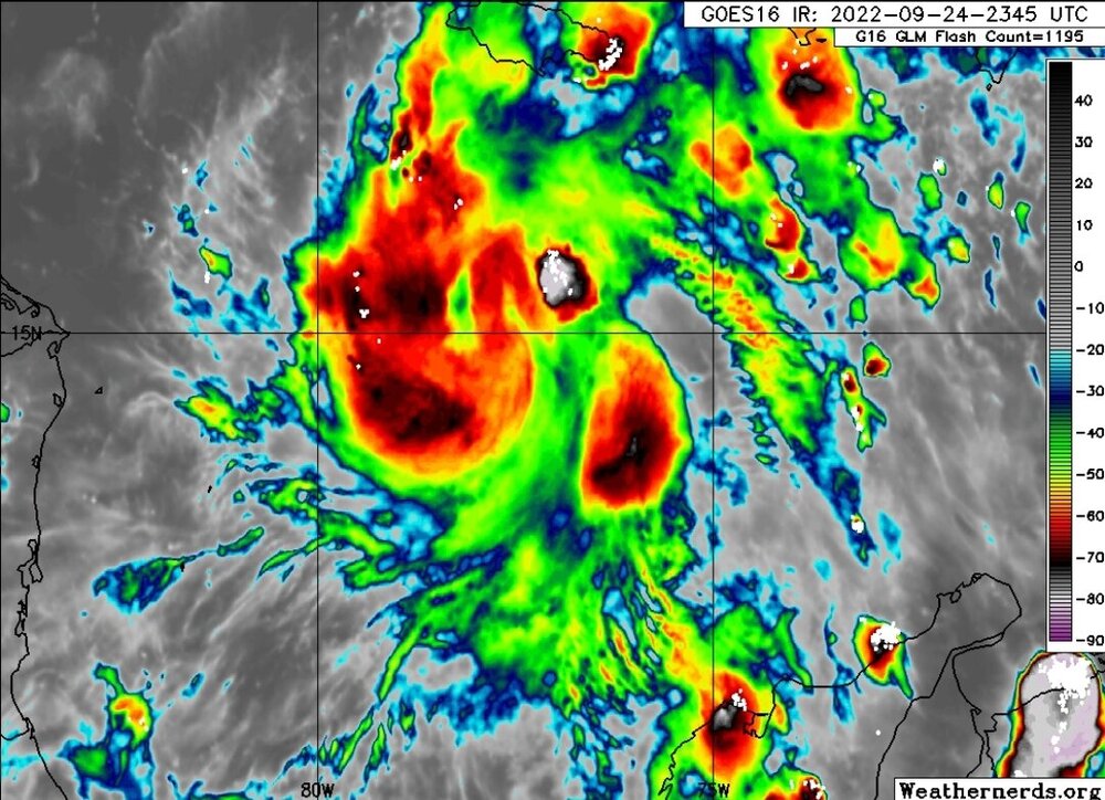
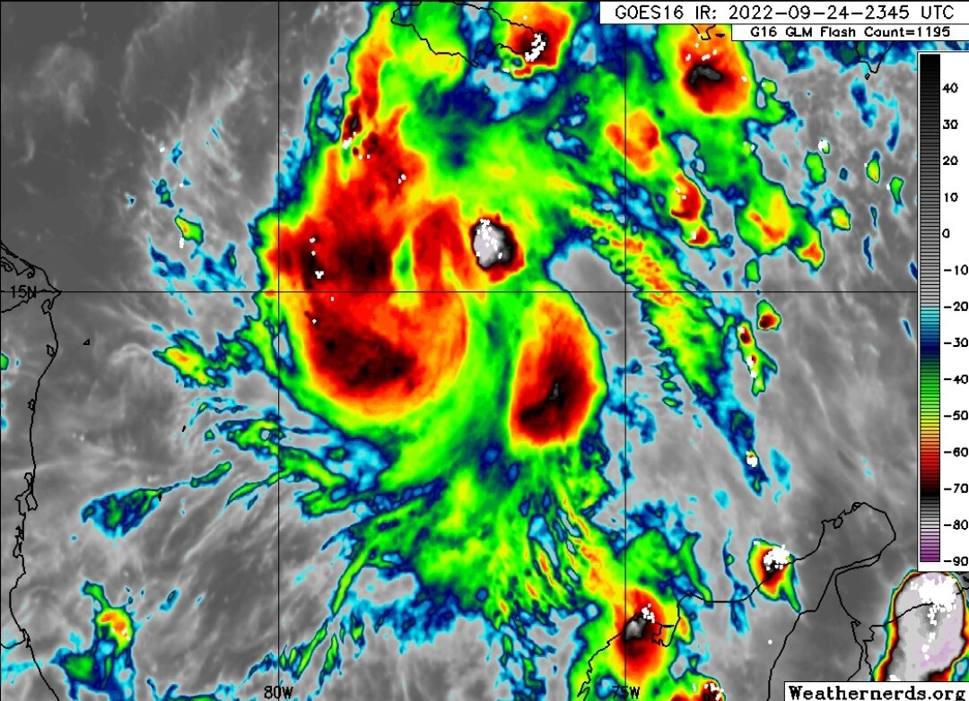
Sure is looking like it is consolidating. Pinwheel at those hot towers?
-
 1
1
-
-
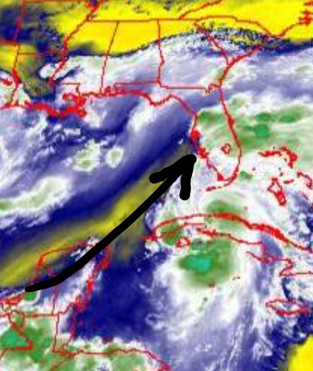
You can see on the 18z ICON 500 heights it holds back the trough in the Ohio Valley as Ian comes off the tip of Cuba like the Euro. At 12z it was more progressive like GFS. Flip flop.
-
2
-
-
4 minutes ago, Hoosier said:
Not fake it, but it's a little hard to imagine it dropping from 130 mph to 105 mph, especially on that forecast path. The implication is actually for even weaker at landfall as the last forecast point is still a decent distance from the coast.
Lows in Northern Florida are near 60F early this week. The dry air is real up there.
-
2
-
-
10 minutes ago, SnowGoose69 said:
A bit surprised they took it all the way down to 90kts at the end, tendency in recent years has been away from that, even if models suggest it because it can lead the public to think the storm is not as much a threat in the whole relativity idea if it was a strong Cat 4 at one stage
So you want them to fake a forecast?
-
44 minutes ago, TPAwx said:
Region wide run on water and basics started yesterday. Many Target and Publix locations out of water already.
Most here take hurricane hype in stride given the rarity of actual impacts, but feels like more are in tune with scarcity after the 2020 pandemic driven issues with staples and necessities. You snooze you lose.
I was laughing at a lady yesterday at Costco in Orlando. She bought enough water to fill a swimming pool. And you could see panic in her almost running with her cart. Smh.
-
34 minutes ago, Sandstorm94 said:
latest Icon stalled him inland, over 2 feet of rain in Orlando
Sent from my SM-S102DL using Tapatalk
Through what hr? I'm seeing 1.4" through hr 192 (Thurs).
-
4 minutes ago, Prospero said:
NHC has been pretty good five days out the past years. Ian is still in flux, but Tampa Bay has not been in this deep in the forecast for quite a while.
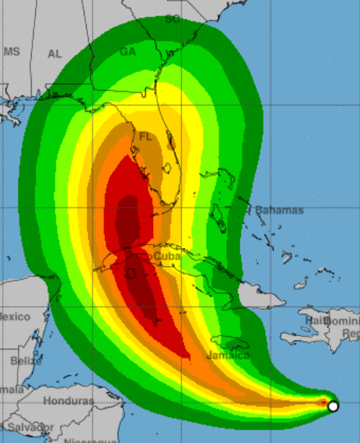
This forecast track is an I-4 special
-
1
-
-
3 minutes ago, Weather Mike said:
What caused Charlie to change paths and head in earlier ? Is the environment around for a similar possibility with this TD as it head up the west coast of FL as a Hurricane ?
Charlie turned quicker because the trough came in stronger than forecasted. It was an unseasonably strong trough.
-
1
-
-
19 minutes ago, Siesta Key said:
We just moved here to Sarasota from the DMV three months ago. Thanks for all the insights here. Hope Euro is right. Keep shifting east please.
I moved here from the DMV a decade ago. My advice is please don't panic or panic buy. DMV was the worst in weather situations with clearing shelves from stores. Download a hurricane checklist and use that as a guide. Listen to local authorities.
-
2
-
-
3 minutes ago, CamSE-Wx said:
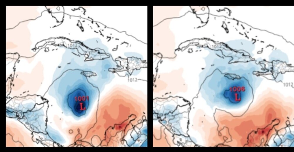
GFS coming in east & stronger through 108. Pressure down from 986 to 983 from the 12z run.
That would make more sense but my map says 953 MB at that position.
-
1
-
-
GFS 18z vs 12z a little east at hr 108. Closer to the tip of Cuba. But 33 MB stronger if I'm reading that right??
-
1
-
-
36 minutes ago, StantonParkHoya said:
Feels more like a mid-October storm with the temps and overall synoptic pattern ahead and behind it. Chilly in the east.
edit: also noticeable is the drop in intensity is now uniform in all hurricane models once in northern gulf, likely reacting to dry air/sheer accompanying the trough.
A lot keep talking about how chilly it's been. Florida must not be participating. 93 with heat index of 105 IMBY. But I looked at temps tonight across the East and was surprised.
-
1 minute ago, StantonParkHoya said:
GFS already 300 miles NE of 6z
Noticeable change N and E thru 60
-
1
-
-
1 hour ago, Brian5671 said:
yeah Charley went in much further S than expected, the friction with the land pulled him in near Port Charlotte, FL.
-

Land had no bearing on the hurricane direction. There was an unseasonable trough that came in stronger than forecasted.
-
1
-
-
28 minutes ago, ldub23 said:
JB brings up 1954. I would take that in a heartbeat right now.
I keep looking at 1950. Florida has been hot, dry this summer especially on the eastern side of the peninsula. I've have about 5" of rain since mid-June. 1950 had a very similar set up in the 850 winds and Andy posted about it earlier. It all changed mid to late Aug into Oct when the pattern became wet. Just throwing that out there.
-
1
-
-
9 minutes ago, Sandstorm94 said:
I am, she is a deeper storm than this morning and the shear vector for the midlevels is out the west-southwest, which should have pushed her more east but it hasn't...
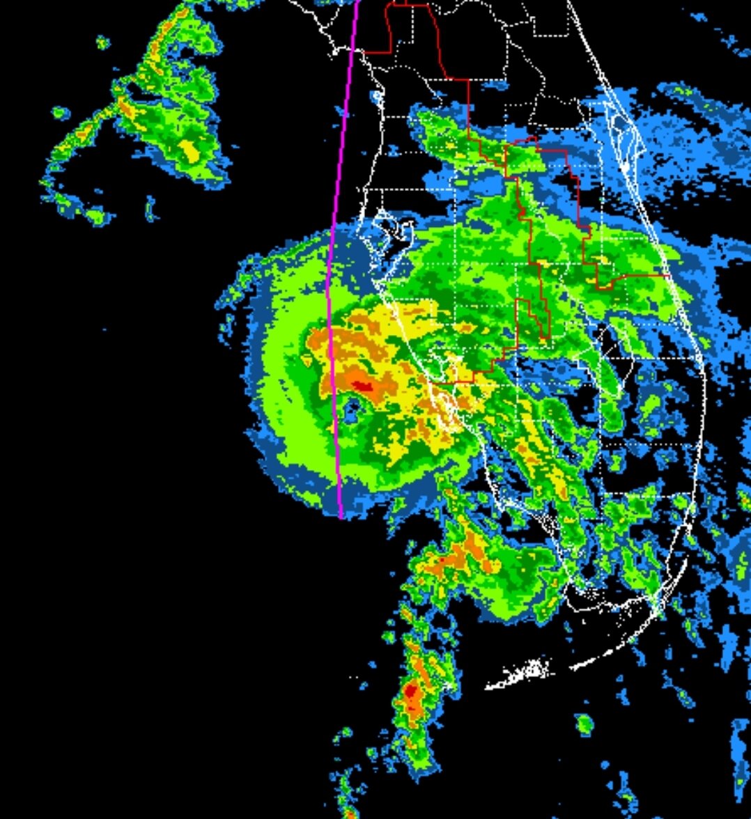
The mid-afternoon recon had her center at 25.4N 82.95W
Last recon fix was 26.8N, 83.4W
So she is still heading NNW, not N/NNE
Sent from my LGL322DL using Tapatalk
Could be a wobble. I also remember a few 12z members showed a jump towards land approaching Sarasota then a jog back W before N. I thought it was odd but might be realized.
-
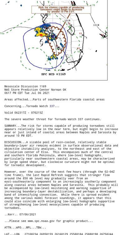
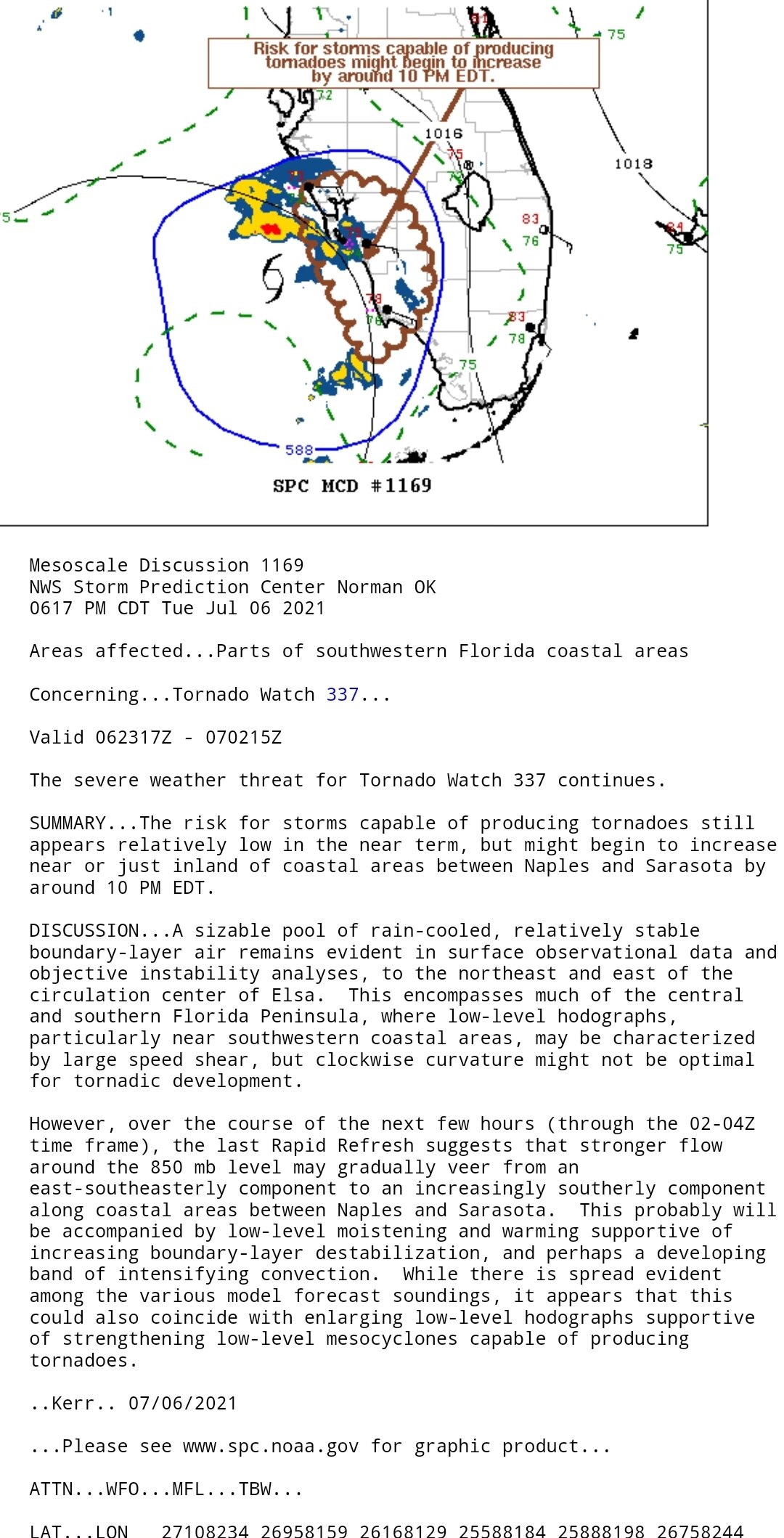
Risk of tornadoes expected to increase Naples to Sarasota around 10 PM per SPC
-
1
-
-
Came together nicely. I see those dark reds just popping up. Extrapolated, it has deviated from the pink line. Maybe a wobble, maybe from consolidation, or maybe an early N-NE trend.

-
Are any rainfall totals verifying? Seems like a lot of dry air is mixing in this storm.
-
NWS Melbourne midday analysis confused me a bit. They talked about Elsa's more westward track than anticipated and new guidance suggesting a slightly more west track. It looks to be verifying slightly east. Who knows.
-
20 minutes ago, rogue said:
I think folks from Sarasota to Tampa may be in for a closer track than currently projected. The mesoscale models certainly seem to think so. May not make much difference as all the nasty weather is focused at or to the east of the center. However, the other item to note is how much intensification. I know the shear is there but all models show a window of deepening before weakening. The 12z Euro even suggested briefly to hurricane level. That window may hit Sarasota to Tampa which could mean a nastier storm in that corridor than currently forecast. Just saying.
Agree but the Euro had it over water up past Cedar Key. Any track east would minimize time to strengthen. NHC did nudge their track slightly east. Will be interesting to see how it unfolds. Sometimes there is a surprise.
-
11 minutes ago, rogue said:
Interestingly, looks like Elsa went through the gap between the two more mountainous areas to the west and east. Radar images, although easy to misinterpret as precip doesn't necessarily line up neatly with central pressure, does seem to suggest a more northward forward motion of Elsa than the NHC's 325 degrees NW report at 8:00 PM.
It just seems that SW shear is acting like a wall. That flow on water vapor seems to be like a wall. Might be reason for the NNW jog.

-
16 minutes ago, Eskimo Joe said:
Looks like it may have nudged NW a bit since 18z?
Looks east FL thru SC but still exits by VA Beach.
Edit: the difference seems to be favoring a more NNW track rather than NW exiting Cuba.
-
2
-
-
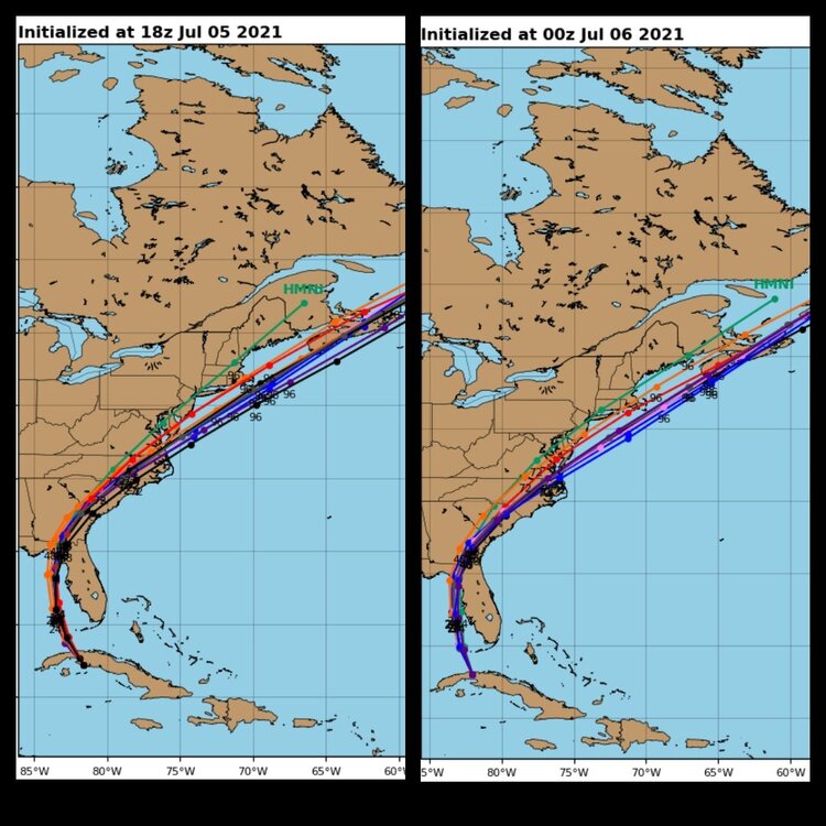
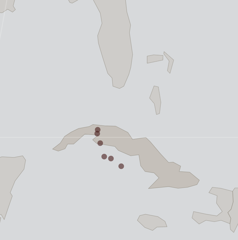
I plotted all estimated center locations by the NHC since 5 AM today. The movement certainly looks like it shifted from NW to NNW. I suspect they'll get better coordinates when the plane flies in but it will look odd to see any jump to the W. The trend favors the east cone track but time will tell.


Hurricane Ian
in Tropical Headquarters
Posted
I thought Levi said stronger earlier was the GFS solution. Euro was stronger later.