.jpg.93eb8afe5d1df4d67bc0eeb78d645380.jpg)
.jpg.7cbeb4b469bd18d447fac5868c43a091.jpg)
Yardstickgozinya
-
Posts
810 -
Joined
Content Type
Profiles
Blogs
Forums
American Weather
Media Demo
Store
Gallery
Posts posted by Yardstickgozinya
-
-
We are not the only ones enjoying this wet and stormy Sunday. This fellow found himself a thick girl but she's playing hard to get. All eggs get safely relocated to the pond down the street teaming with other wood frogs and various other tadpoles and eggs.


-
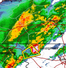
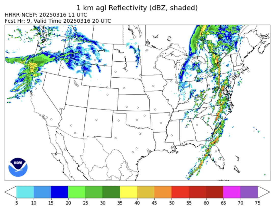
Severe Thunderstorm Warning
Severe Thunderstorm Warning
PAC071-133-170215-
/O.NEW.KCTP.SV.W.0010.250317T0132Z-250317T0215Z/

BULLETIN - IMMEDIATE BROADCAST REQUESTED
Severe Thunderstorm Warning
National Weather Service State College PA
932 PM EDT Sun Mar 16 2025

The National Weather Service in State College PA has issued a

* Severe Thunderstorm Warning for...
  Lancaster County in south central Pennsylvania...
  Southern York County in south central Pennsylvania...

* Until 1015 PM EDT.

* At 931 PM EDT, a severe thunderstorm was located over Spring Grove,
  moving northeast at 70 mph.

  HAZARD...60 mph wind gusts and nickel size hail.

  SOURCE...Radar indicated.

  IMPACT...Expect damage to roofs, siding, and trees.

* Locations impacted include...
  Buck, York Airport, Stonybrook-Wilshire, Red Lion, Millersville
  University, Reinholds, Cross Roads, Loganville, New Holland, East
  York, Blue Ball, and Georgetown.

This includes the following Interstates...
 The Pennsylvania Turnpike from mile markers 268 to 294.
 Interstate 83 from mile markers 0 to 23.

PRECAUTIONARY/PREPAREDNESS ACTIONS...

Stay inside a well built structure and keep away from windows.

&&

LAT...LON 3988 7697 4025 7638 4025 7631 4031 7615
      4013 7589 4010 7594 4004 7594 3996 7599
      3972 7664 3972 7693
TIME...MOT...LOC 0131Z 234DEG 62KT 3986 7684

HAIL THREAT...RADAR INDICATED
MAX HAIL SIZE...0.88 IN
WIND THREAT...RADAR INDICATED
MAX WIND GUST...60 MPH

$$

KF
Special Weather Statement
Special Weather Statement National Weather Service State College PA 916 PM EDT Sun Mar 16 2025 PAZ064-065-170145- York PA-Adams PA- 916 PM EDT Sun Mar 16 2025 ...A STRONG THUNDERSTORM WILL IMPACT SOUTHEASTERN ADAMS AND SOUTHERN YORK COUNTIES THROUGH 945 PM EDT... At 916 PM EDT, Doppler radar was tracking a strong thunderstorm over Taneytown, moving northeast at 70 mph. HAZARD...Wind gusts up to 50 mph and pea size hail. SOURCE...Radar indicated. IMPACT...Gusty winds could knock down tree limbs and blow around unsecured objects. Locations impacted include... Dallastown, Hanover, North York, Mount Wolf, West York, York, East Prospect, Windsor, York Airport, Spring Grove, Stonybrook-Wilshire, Parkville, Red Lion, Glenville, Pennville, Loganville, New Salem, Glen Rock, East York, and Yorklyn. PRECAUTIONARY/PREPAREDNESS ACTIONS... If outdoors, consider seeking shelter inside a building. & -
9 minutes ago, anotherman said:
Oh man that cell near Hanover looks bad.
Pretty amazing they let it outrun it's box.
-
There's another very intense cell crossing the MD line into York co. atm. Looks like super cell structure to me.. I apologize for the edits I hid it right the first time .
-
these line segments breaking into some arking cells is interesting and something to keep an eye on especially in eastern cpa.
-
@Jns2183We got a trainer right were the sun don't shine.
-
3 hours ago, Blizzard of 93 said:
Would you say “it’s training time”? Lol
Good call . Maybe spring needs the optimism only the Blizz can provide.
-
 1
1
-
-
I ment signature not structure. It also had a nice hail core as it crossed the MD line.
-
The cluster of cells over us now briefly had super cell structure as it crossed are Md line.
-
38 minutes ago, mahantango#1 said:
temp is 62 with a dewpoint of 59. Clouds are really moving fast.
I tried to pull up the soundings for BWI because I believe that's the closest available to both of us, but unfortunately, the only soundings that were available atm where Norman Ok. No matter what station I selected.
-
1
-
-
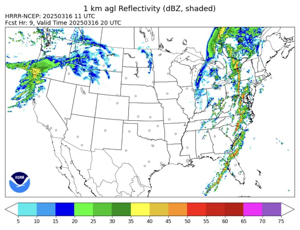
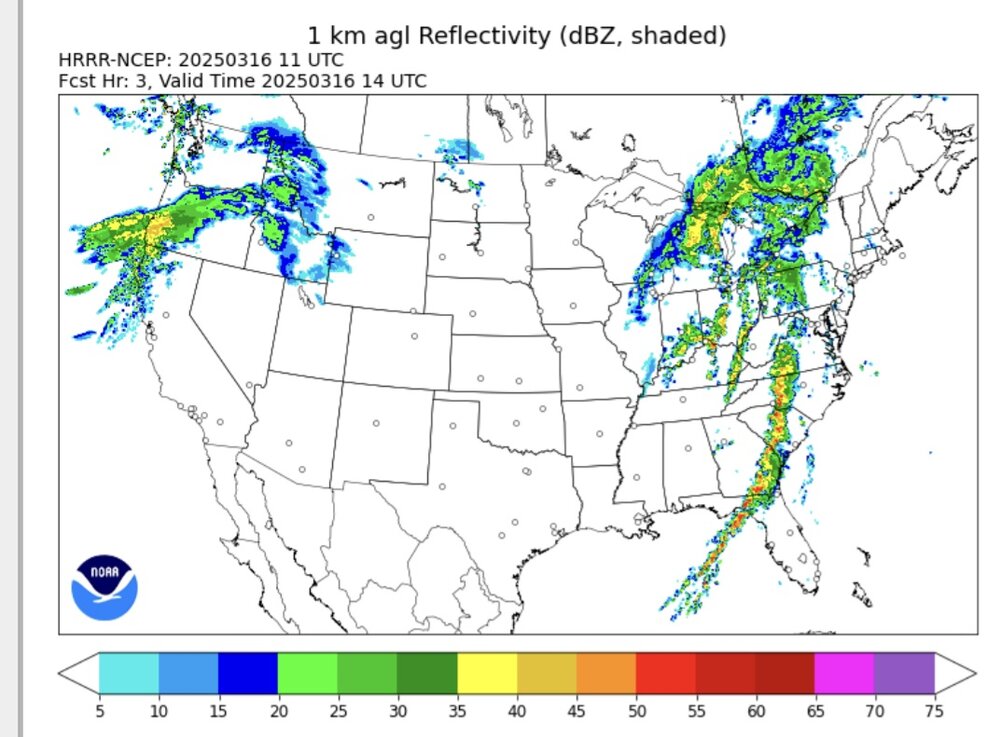
Take it with a grain of salt, but the Hrrr has the idea of bringing a line of storms into wcpa around 4:00pm and what looks to be a more discreet cellular storm into southern York Lancaster co.
-
1
-
-
The fog and mist dissipated just before sunrise but it's still slightly damp and cloudy here.
-
1
-
-
15 minutes ago, mahantango#1 said:
Almost seems like a summer morning.
I was thinking classic spring with the fog and mist. That may not be the case where your at. It's still a awesome morning either way . Many birds are back and the peepers are in full chorus.
-
1
-
-
-
I don't think I have ever seen a vort max so evident on traditional radar before the fetch.
-
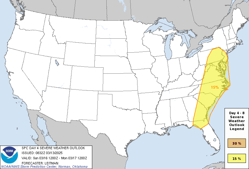
Sunday
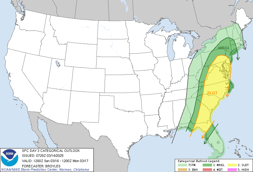
SPC AC 140729
Day 3 Convective Outlook NWS Storm Prediction Center Norman OK 0229 AM CDT Fri Mar 14 2025
Valid 161200Z - 171200Z
...THERE IS A SLIGHT RISK OF SEVERE THUNDERSTORMS IN THE ATLANTIC
COASTAL STATES FROM NORTHERN FLORIDA TO SOUTHEAST PENNSYLVANIA...
...SUMMARY...
Severe storms with large hail, severe gusts and possibly a few tornadoes, are expected on Sunday across parts of the Atlantic Coastal States.
...Atlantic Coastal States...
A mid-level trough will move eastward across the mid Mississippi Valley and western Great Lakes on Sunday, as an associated mid-level jet translates eastward into the southern and central Appalachians.Ahead of this feature, a south-to-north corridor of low-level moisture will be in place early in the day in the lee of the Appalachians, from Georgia north-northeastward into the Mid-Atlantic. Surface dewpoints along this corridor should be mostly in the 60s F. Along the western edge of this moist airmass, thunderstorms appear likely to be ongoing at the start of the period. The storms are forecast to move eastward from the higher terrain of the Appalachians into the lower elevations during the day. Ahead of the storms, some destabilization is forecast. ECMWF forecast soundings near the moist axis suggest that MLCAPE will peak in the 500 to 1000 J/kg range Sunday afternoon.
In addition to the instability, strong deep-layer shear is forecast across most of the region due to the presence of the mid-level jet. As this feature moves to the east of the spine of the Appalachians, deep-layer shear is forecast to gradually increase. This will be favorable for a severe threat, associated with the stronger multicell line segments and/or rotating storms. Wind damage will be most favored along the leading edge of the faster-moving lines. Cells that remain discrete, and move into areas where the combination of instability and deep-layer shear is locally maximized, could become supercellular. Supercells will likely have potential for severe gusts and isolated large hail. An isolated tornado threat will also be possible, with the greatest tornado threat concentrated along and near the low-level jet during the afternoon, from the Carolinas into Virginia.
Further north into the Hudson Valley, severe storms will also be possible. However, forecast instability in the Hudson Valley is less, suggesting the severe threat should remain marginal and more solated.
..Broyles.. 03/14/2025
-
1
-
-
-
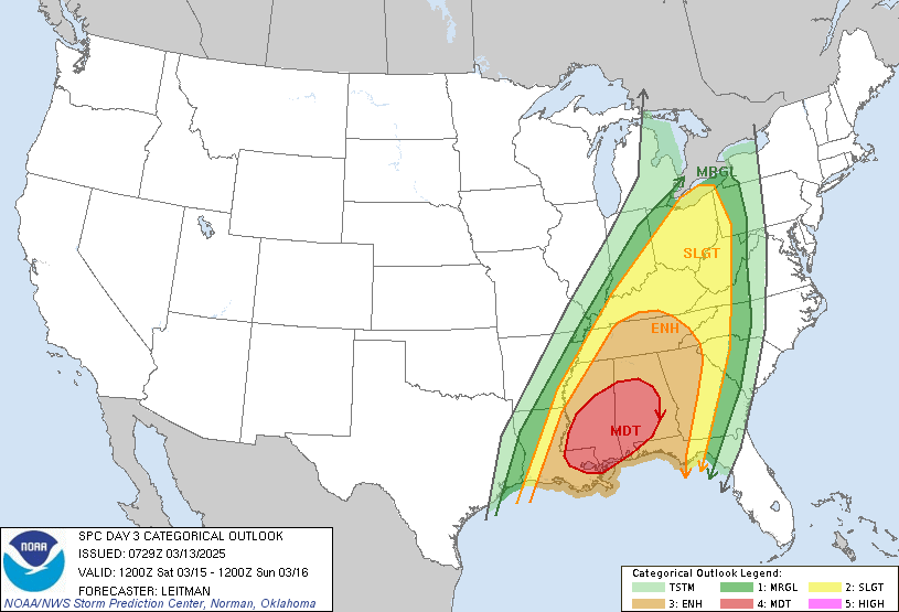
-
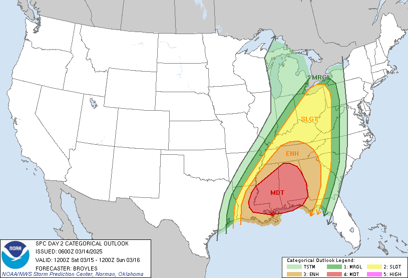
A large-scale upper trough near the MS Valley Sunday morning will develop east to the Appalachians by early Monday. Strong deep-layer south/southwesterly flow on the eastern side of the upper trough will overspread much of the eastern U.S. Convection will likely be ongoing Sunday morning from the Upper OH Valley into GA and northern FL. This activity will move into a moist airmass, characterized by 60s F dewpoints from north FL toward the Chesapeake Bay vicinity (50s F dewpoints further north into PA/NJ). Instability will be greatest where deeper boundary layer moisture is forecast, but given intense deep-layer flow, organized convection is expected with even very modest instability. While linear convection producing damaging gusts will be the main hazard for much of the region, tornado potential will exist where sufficient boundary layer moisture exists, most likely from the Carolinas southward.
-
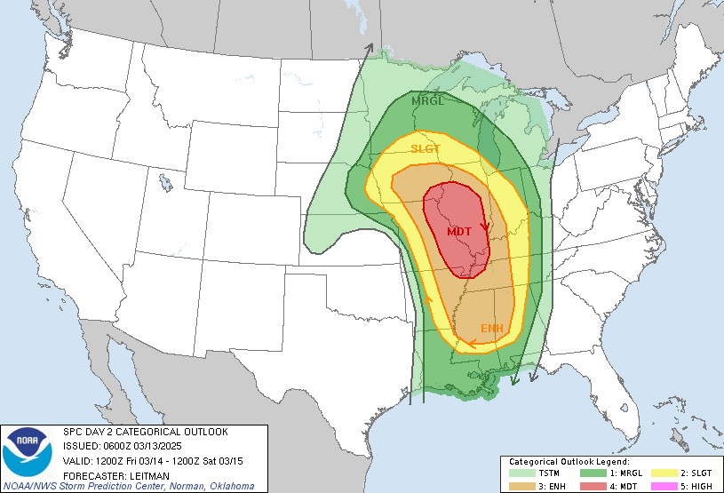
 SPC AC 130729
Day 3 Convective Outlook
NWS Storm Prediction Center Norman OK
0229 AM CDT Thu Mar 13 2025
Valid 151200Z - 161200Z
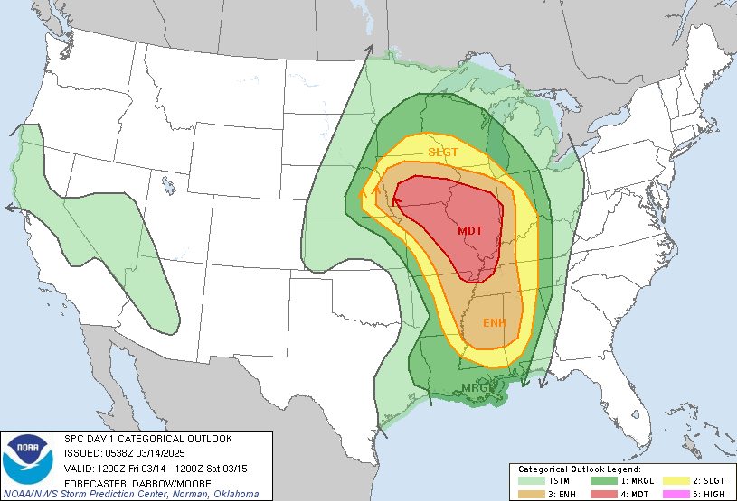
...THERE IS A MODERATE RISK OF SEVERE THUNDERSTORMS OVER PORTIONS OF SOUTHEAST LOUISIANA INTO SOUTHERN AND CENTRAL MS/AL...
...SUMMARY...
A severe weather outbreak is expected on Saturday from the central Gulf coast states/Deep South into the Ohio Valley. Significant tornadoes (focused across the South), swaths of damaging gusts, and hail are expected.
...Synopsis...
An upper cyclone over the Upper Midwest will lift northeast into Ontario through Saturday evening. Meanwhile, a large-scale upper trough over the Plains will eject east toward the MS Valley. Strong southwesterly mid/upper flow (with a 500 mb jet streak near 100 kt)will overspread the Lower MS Valley/Mid-South vicinity by 00z, and continue east/northeast overnight into the Ohio Valley and central Appalachians. An intense south/southwesterly low level jet greater than 60 kt is forecast to overspread the central Gulf coast/DeepSouth into the TN/OH Valley during the late afternoon and nighttime hours. Rich Gulf moisture with dewpoints in the mid/upper 60s is expected to be focused over LA/MS/AL and the FL Panhandle, and possibly as far north as Middle TN and far western GA. 50s to low 60s F dewpoints will extend north into the Ohio Valley. This should support a widespread risk for severe storms across much of the central into the southeastern U.S. Saturday into early Sunday.
...Deep South/TN Valley vicinity...
Forecast guidance has generally trended toward less widespread precipitation coverage Saturday morning as stronger height falls are not expected until late morning/early afternoon as the Plains trough ejects and a surface low begins to develop over the Mid-South. Persistent strong southerly low-level flow will allow for a moisture-rich boundary layer that should remain relatively pristine across southeast LA into southern/central MS/AL before convection develops by midday. Forecast soundings show cooling aloft will support steep midlevel lapse rates atop this moist boundary layer, leading to MLCAPE values perhaps approaching 2000 J/kg (decreasing with northward extent in Middle TN). Vertically veering wind profiles with strong anvil-level divergence amid moderate instability should support robust updrafts and intense supercells.Significant tornadoes, damaging gusts and large hail will be possible through the afternoon and spreading into AL during the evening/nighttime hours.
Additional convection is expected to develop along an eastward-advancing cold front during the afternoon and into the overnight. An organized line of storms will pose a risk for damaging wind swaths and tornadoes across northern MS/AL into TN, eastward into GA and the western Carolinas overnight.
...Ohio Valley...
Very strong deep-layer flow will be in place across the Ohio Valley on Saturday with some convection possibly ongoing from southeast Lower MI into western/central KY. The extent of severe potential is uncertain and dependent on how much precipitation occurs early in the forecast period. Too much convection early in the day could largely limit destabilization and temper the overall risk. However, if less convective contamination occurs, greater destabilization could occur ahead of a deepening surface low lifting northeast from the Mid-South to OH during the evening. Given the strength of deep-layer flow at least some risk of strong/damaging gusts within bands of thunderstorms should occur through Saturday night.
..Leitman.. 03/13/2025
-
SPC AC 130600
Day 2 Convective Outlook NWS Storm Prediction Center Norman OK 0100 AM CDT Thu Mar 13 2025 Valid 141200Z - 151200Z
...THERE IS A MODERATE RISK OF SEVERE THUNDERSTORMS ACROSS EASTERN MISSOURI...FAR SOUTHEAST IOWA...CENTRAL AND SOUTHERN ILLINOIS...FAR WESTERN KENTUCKY...FAR NORTHWEST TENNESSEE...AND EXTREME NORTHEAST ARKANSAS...
...SUMMARY...
A regional outbreak of severe storms is expected across much of the Mississippi Valley, eastward to the Lower Ohio and Tennessee Valleys late Friday afternoon into Saturday morning. Widespread damaging winds (some greater than 65 kt), several tornadoes (some strong),and large hail will all be possible.
...Synopsis...
An intense cyclone will develop from the central Plains to the Upper Midwest on Friday. As this system rapidly deepens, an intense jet streak (100+ kt at 500 mb) will overspread the Ozarks and Mid-MS Valley. Meanwhile, a large area covering much of the MS Valleyvicinity will see 850-700 mb southwesterly flow around 65-80 kt.Southerly low-level flow will transport mid 50s dewpoints as far north as IA/northern IL (decreasing with northward extent across the Upper Midwest). Richer boundary layer moisture (60s F dewpoints) will be confined to the Lower MS Valley and Deep South/TN Valley,though near-60 F dewpoints may reach the MS/OH River confluence.Rapidly developing convection is expected to develop by late afternoon from near a surface low over eastern NE and arcing east/southeast along a dryline into the Ozarks. Convection will develop northeast across the Mid-MS valley, with additional storms develop with southward extent into the Mid-South and TN Valley during the nighttime hours.
...Mid/Upper Mississippi Valley to the Lower OH/TN Valleys... Cold temperatures aloft near the main upper low will support steep midlevel lapse rates. While boundary moisture will be modest, MLCAPE up to 1000-1500 J/kg is possible. This will support rapid storm development amid intense deep-layer shear. Heating ahead of the dryline also will support some boundary layer mixing and steepening of low-level lapse rates. As a result, a rapidly developing QLCS is expected. Convection will shift east/northeast into the nighttime hours. Given fast storm motion and the intensity of deep-layer flow,swaths of significant wind gusts (greater than 65 kt) are anticipated over a large part of the Mid-MS Valley. A gradual weakening of convection is expected after midnight with north and east extent.
With southward extent from parts of eastern MO/western IL into theMid-South, some potential for a mix of linear convection and supercells appears possible. Vertical shear will support tornadoes within linear convection. The environment will especially be favorable for strong tornadoes with any supercells that develop. This activity may develop a little later than initial convection further north, with much of the threat being after dark from east-central MO/west-central IL southward to western TN. Given the intensity of maximum gusts expected, and widespread coverage of damaging gusts, a Moderate risk (level 4 of 5) has been included for portions of the Mid-MS Valley vicinity.
...MS/AL/TN Overnight...
Persistent southerly low-level flow will bring mid to possibly upper 60s F dewpoints northward into the TN Valley overnight. Neutral to modest height falls are expected and a persistent, strong low-level jet will overspread the region. Forecast soundings indicate very favorable thermodynamic and kinematic profiles, which would support intense supercells. Forcing mechanisms will be somewhat modest over the region, which may limit convective coverage, and a somewhat more conditional risk. However, any storms that develop within this environment overnight will pose a risk for strong tornadoes, large hail and damaging gusts.
...Upper Midwest/Great Lakes vicinity...
The severe risk will become more marginal into MN/WI/MI. Strong deep layer flow will overspread the region and any convection will pose a risk of strong gusts. An additional risk for hail also will exist,especially with any elevated convection near the warm front overnight.
-
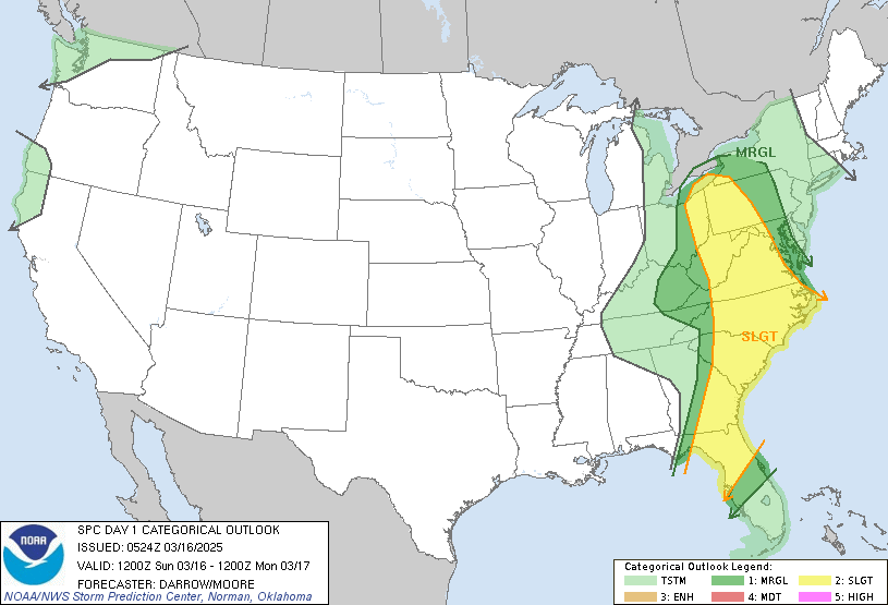
Still not many details for Sunday but the spc has expanded the slight risk coverage nort and a slight tick west in PA.
.gif.00ae428bb2532347409e8db09efbaff1.gif)
-
1
-
-
2 minutes ago, Yardstickgozinya said:
I posted a spc quick discussion about this two days ago . Spc has not released many details yet in their discussion for sunday but did initially mention that training precipitation could be a limiting factor for severe weather in the east on Sunday.
Point being they initially mentioned the Mid-Atlantic 8 days out.
-
1
-
-
Unfortunately there's alot of mention of nocturnal storms and tornadoes for Friday and Saturdays possible outbreak.

Central PA Spring 2025
in Upstate New York/Pennsylvania
Posted
Day 7