.jpg.93eb8afe5d1df4d67bc0eeb78d645380.jpg)
.jpg.7cbeb4b469bd18d447fac5868c43a091.jpg)
Yardstickgozinya
-
Posts
342 -
Joined
-
Last visited
Content Type
Profiles
Blogs
Forums
American Weather
Media Demo
Store
Gallery
Posts posted by Yardstickgozinya
-
-
The first cell approaching farmville Va looks very suspicious. But all those storms seam like they mean business atp
-
Yes the storms in Va are getting nasty fast. One storm just had one hell of a hail core on it. Several have taken super cell form . I got to get back to work . Have a great day .
-
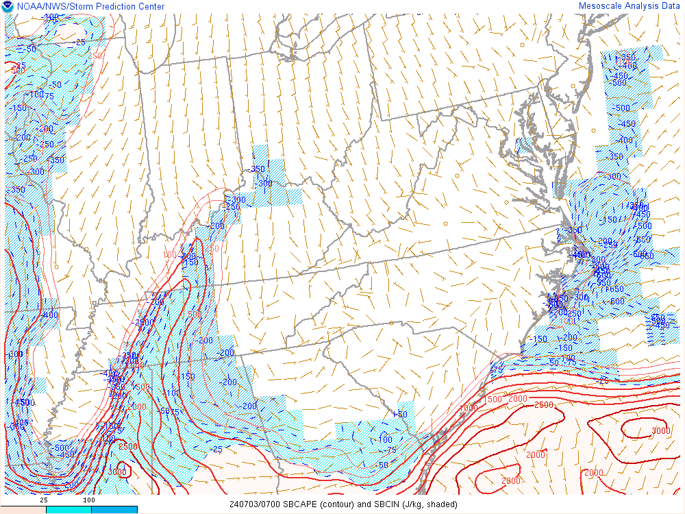
- I couldn't find soundings close to the area of 3000j/kg but the closest station has some veering at around 3km.
-
 1
1
-
missed Va with 3000j/kg looking at Delaware.
-
-
Southern Delawere and Md are looking ripe again yet today. Yesterday they had surface cape of nearly 2000j/kg but nothing around to tap the energy. Today is a different story 1000-2000j/kg at the surface atm with a breaking cap. The good news is the winds are not turning with height nearly as much as the other day. They do seam primed for downdrafts if I'm reading meso downdraft map correctly .
-
I was hoping to get to see a little more lightning than I got tonight . Seems like I did a little better then some. Probably got a little less than 1/4" of rain and maybe 20-25 strikes within earshot. Any nocturnal storm before may is always a win in my book ,and I have had several in the last few weeks .
-
I had no Idea storm chaser Joel Taylor died of an overdose in 2018. I always suspected Reed timmers and crew where on cocaine or stimulants of some kind in the early years. Reed was always tweeked as shit you could see it in his eyes, hear it in his voice an he was always sweating at his temples.
Taylor, 38, had a fatal mix of drugs in his system, according to a toxicology report by the Institute of Forensic Sciences of Puerto Rico in January which was obtained on Friday.MDMA (also known as ecstasy) along with Zolpidem (a version of Ambien), ketamine (an anesthetic) and MDA (a psychedelic amphetamine) were found in his system at the time of his death, according to the report
-
The storms in Mo and Ar are starting to form Hail Cores and finding better rotation but I have not seen a hook or ball yet tonight. Chasers are complaining about the radar down there so maybe I just cant see the hooks.
-
Just found some chasers on these storms. Apparently these are Radar indicated PDS warnings . No confirmed tornadoes on the ground .
-
The night started slow but two PDS tornado warnings have just went up at 3:30Am In Mo and AR
-
I really thought this would have warranted a high risk by the afternoon only because of timing. I sure
hope the spc dose not regret not upgrading tomorrow morning. Better to cry wolf in this situation
I would think.

...ArkLaTex into southern MO/IL Tonight...
   By early evening, forecast soundings from most 12z guidance shows
   that a broad area of high conditional risk of tornadic supercells
   will develop from eastern OK into much of AR and southern MO.  This
   area will still be somewhat capped and the mechanisms for convective
   initiation are uncertain.  However, a consensus of guidance shows
   multiple clusters of supercells forming across this area and
   persisting through the evening.  Wind fields will strengthen
   throughout the night and capping will weaken, leading to a serious
   concern for nocturnal tornadoes over the southern MDT risk area in
   MO/AR.  Again, model guidance provides confidence in the risk of
   widely scattered supercells throughout the night across the area,
   although details of location and timing are uncertain.  Strong or
   even violent tornadoes are possible in this scenario
-
1
-
-
29 minutes ago, Bubbler86 said:
How do you walk in that thing?
Sitting on her shoulders
-
I know I said the other day that youtube is a horrible place to get weather forecast. I have done a full 360 . Its the best place for a late nite weather forecast. What ever the hell she is saying is accurate enough as far as I'm concerned.
-
 2
2
-
-
It kind of reminds me of the old weather Chanel form the 80's and 90's when they would just Highlight 1/3 the country for severe weather. Probably the largest area of ENH I have ever seen. Mod risk some where likely.
Apr 4, 2023 0600 UTC Day 2 Convective Outlook Updated: Tue Apr 4 05:33:47 UTC 2023 (Print Version |  |
|  )
)
Probabilistic to Categorical Outlook Conversion Table Categorical Tornado Wind Hail Pop. Cities CWAs RFCs Interstates Counties ARTCC FEMA Tribal  Categorical Day2 0600Z Outlook
Day 2 Risk Area (sq. mi.) Area Pop. Some Larger Population Centers in Risk Area ENHANCED 229,449 45,085,699 Chicago, IL...Detroit, MI...Indianapolis, IN...Columbus, OH...Memphis, TN... SLIGHT 145,616 16,559,718 Milwaukee, WI...St. Louis, MO...Pittsburgh, PA...Buffalo, NY...Rochester, NY... MARGINAL 176,731 22,545,333 Houston, TX...Corpus Christi, TX...Madison, WI...Baton Rouge, LA...Jackson, MS... Forecast Discussion SPC AC 040533 Day 2 Convective Outlook NWS Storm Prediction Center Norman OK 1233 AM CDT Tue Apr 04 2023 Valid 051200Z - 061200Z ...THERE IS AN ENHANCED RISK OF SEVERE THUNDERSTORMS WEDNESDAY ACROSS MUCH OF THE LOWER GREAT LAKES REGION AND OHIO VALLEY... ...SUMMARY... Scattered severe storms posing a risk for strong tornadoes and large hail are expected in a corridor across eastern Illinois through Lower Michigan Wednesday, with organizing clusters or lines of storms accompanied by potentially damaging wind gusts, and perhaps a couple of tornadoes, across the Ohio Valley vicinity. ...Synopsis... Within the more amplified branch of split flow emanating from the mid-latitude Pacific, the center of a broad and deep, occluding cyclone is forecast to migrate across and northeast of the Lake Superior vicinity before beginning to weaken Wednesday through Wednesday night. As this occurs, it appears that mid-level ridging centered along an axis across the Yucatan Peninsula into western Atlantic will remain a prominent influence across much of the Southeast, while short wave ridging also overspreads the Northeast and Canadian Maritimes. Models indicate a corridor of deepening boundary-layer moisture overspreading the Ozark Plateau and middle Mississippi Valley, into the Lake Michigan vicinity, by early Wednesday. This is forecast to spread across much of the lower Great Lakes and Ohio Valley, ahead of the cold front trailing the cyclone, while the trailing flank of the front stalls across the lower Mississippi Valley into northwestern Gulf coastal plain, beneath the northwestern periphery of the mid-level ridging. ...Illinois through lower Michigan... Beneath a dry slot overspreading the region, south and east of an intensifying cyclonic mid-level jet (in excess of 120 kt around 500 mb), surface heating and steepening mid-level lapse rates are expected to contribute to sufficient destabilization for intensifying supercells. This may commence in a pre-frontal corridor as early as mid Wednesday morning across parts of central into northeastern Illinois, before developing into/across Lower Michigan and parts of adjacent northern Indiana and northwestern Ohio through late afternoon. It remains unclear what effect the cooler marine layer from Lake Michigan has on adjacent coastal areas, particularly into portions of western Michigan. However, Rapid Refresh forecast soundings, in particular, indicate a rather potent thermodynamic and kinematic environment supportive of strong tornadoes. This includes sizable CAPE, strong deep-layer shear and large clockwise-curved low-level hodographs. It is possible that severe weather probabilities could still be increased further in later outlooks for this period. ...Ohio Valley... To the south of the dry slot (within a plume of seasonably high precipitable water, and generally aligned with a belt of 40-70 kt west-southwesterly flow in the 850-500 mb layer), models indicate the potential for more widespread convection, organizing into clusters or lines while overspreading much of the Ohio Valley through the day. While lapse rates may not be particularly steep, given the strong flow, with at least modest CAPE and the increased potential for heavy precipitation loading and organizing convection, the environment probably will become conducive to damaging surface gusts, in addition to some risk for tornadoes. ...Lower Mississippi Valley... South of the Ohio Valley, weakening low-level flow seems likely to result in more limited severe weather potential as the cold front gradually stalls. While a corridor of sizable pre-frontal CAPE beneath strong deep-layer shear may provide a window for strong/severe storm development, this may be limited as convection tends to train above congealing outflow and/or the front. ..Kerr.. 04/04/2023
-
 1
1
-
-
There still seams to be a lot of uncertainty with this system, but given the recent pattern, and loss of life I feel another high risk afternoon, and night is likely for the ArkLaTex region.
Apr 4, 2023 0600 UTC Day 1 Convective Outlook Click to see valid 1Z - 12Z Day 1 Convective Outlook Updated: Tue Apr 4 06:04:35 UTC 2023 (Print Version | | )
Probabilistic to Categorical Outlook Conversion Table Categorical Tornado Wind Hail Pop. Cities CWAs RFCs Interstates Counties ARTCC FEMA Tribal  Categorical Day1 1200Z Outlook
Day 1 Risk Area (sq. mi.) Area Pop. Some Larger Population Centers in Risk Area MODERATE 55,302 3,086,437 Springfield, MO...Cedar Rapids, IA...Davenport, IA...Waterloo, IA...Iowa City, IA... ENHANCED 112,252 11,594,437 St. Louis, MO...Madison, WI...Des Moines, IA...Little Rock, AR...Aurora, IL... SLIGHT 183,658 27,761,618 Chicago, IL...Dallas, TX...Austin, TX...Milwaukee, WI...Kansas City, MO... MARGINAL 218,591 26,976,221 San Antonio, TX...Indianapolis, IN...Memphis, TN...Fort Worth, TX...Minneapolis, MN... Forecast Discussion SPC AC 040604 Day 1 Convective Outlook NWS Storm Prediction Center Norman OK 0104 AM CDT Tue Apr 04 2023 Valid 041200Z - 051200Z ...THERE IS A MODERATE RISK OF SEVERE THUNDERSTORMS THERE IS A MODERATE RISK OF SEVERE THUNDERSTORMS FROM EASTERN IOWA INTO NORTHWEST ILLINOIS AND NORTHEAST MISSOURI...AND FROM SOUTHERN MISSOURI SOUTHWESTWARD TOWARD THE ARKLATEX... ...SUMMARY... A large area of severe potential will develop today into tonight, from eastern portions of the Plains into the Missouri and mid/upper Mississippi Valleys. Strong, potentially long track tornadoes are possible, in addition to large hail and damaging winds. Both afternoon and overnight potential is expected across various regions, including the risk of dangerous nighttime tornadoes. ...Synopsis... A deep upper trough will move from the Intermountain West/Rockies toward the Great Plains today. Within the large-scale trough, an upper cyclone will deepen as it moves northeastward toward the Dakotas. An 80-100 kt midlevel jet will overspread the central Plains during the afternoon/evening, while a secondary jet maximum intensifies through the day from the southern Plains into parts of the Midwest. At the surface, a broad cyclone will gradually consolidate and deepen as it propagates from the central High Plains toward western IA by early evening. A warm front will move northward into central/northern IA and northern IL by late afternoon, and into parts of WI/lower MI late tonight. A dryline will extend southward across eastern portions of the central/southern Plains, with a cold front expected to sweep through the Plains/Midwest this evening into the overnight. ...Iowa into parts of the Great Lakes states... Short-term guidance continues to vary greatly regarding the extent of mixing across the warm sector over parts of the Midwest later today. The typically overmixed RAP/HRRR drop surface dewpoints to near 60F south of the warm front as temperatures warm to near 90F, while the generally undermixed NAM maintains cooler temperatures and upper 60s F dewpoints across the warm sector, and is slower to advance the warm front northward. The current expectation is for the magnitude of mixing to be somewhere between these two extremes, with dewpoints remaining in the mid 60s in closer proximity to the warm front, with somewhat stronger mixing possible farther south. Considerable spread remains regarding convective evolution among regional/global guidance and CAMs. However, two areas of possible storm initiation this afternoon are evident. The first is near the MO/IA/IL border region, where substantial warming/moistening beneath steep midlevel lapse rates will result in rapid destabilization near/south of the warm front. Any supercell that develops in this region during the afternoon will pose a threat of very large to giant hail. Very favorable low-level and deep-layer shear will support a threat of strong tornadoes as well for as long as any supercell traverses the warm sector along/south of the warm front. The second area of potential initiation will be farther west across west-central IA, closer to the surface low. Some uncertainty remains regarding the moisture quality this far west, but moderate buoyancy and very favorable wind profiles will support a threat of supercells capable of all severe hazards, including the potential for a strong tornado or two with any cell that can persist in the warm sector. Additional convection may develop later tonight in association with the cold front and move into the region, posing a threat of hail and damaging gusts. A conditional tornado threat will also persist overnight with any sustained supercells. Finally, storms capable of hail will be possible north of the warm front, where MUCAPE in excess of 1000 J/kg, steep midlevel lapse rates, and sufficient deep-layer shear will support elevated supercell potential, despite rather cold surface temperatures. ...Southern Plains into the Ozark Plateau... A very favorable severe thunderstorm environment will also reside across the southern Plains into the Ozark Plateau, beginning this afternoon and persisting overnight east of the dryline/cold front. Diurnal storm development along the dryline is expected to be isolated at best, with large-scale ascent remaining weak for much of the day. However, convection is expected to increase this evening and especially overnight from northeast TX into AR and southern MO, within a persistent low-level moist plume associated with a strong low-level jet. Moderate buoyancy and very favorable wind profiles will support supercells, both with diurnal storms (if any develop) and nocturnal convection. Some nocturnal storms may be somewhat elevated (at least initially) and the mode may be a mix of discrete cells and clusters, but weak MLCINH will not prohibit surface-based convection, and the current expectation is for supercell potential to increase overnight. Any nocturnal supercells will be capable of all severe hazards, and the concern remains regarding the potential for nocturnal strong tornadoes from near the ArkLaTex region into parts of southern MO. ..Dean/Thornton.. 04/04/2023
-
1
-
-
Unfortunately today I fond out my sons friend and a boy I have watched grow up has contracted Spinal Meningitis. He is only 16 and one of the nicest kids you will ever meet, a fantastic athlete, honer student and sophomore at cedar cliff high school . Unfortunately I just got a call that prayers are much needed for Gunner. The only thing I can do is ask for as many prayers for Gunner as I can find.

-
 1
1
-
-
The spc highlights are almost a carbon copy if the 31 as far a location. According to the spc the quality of moisture return is still questionable, and possible convection and cloud cover from the subtropical pacific could limit destabilization out ahead of the system. I think there is more bust potential with this system than the last atp. However I'm not calling a bust, just pointing out the potential, It could go either way atp.
Apr 3, 2023 0600 UTC Day 2 Convective Outlook Updated: Mon Apr 3 05:03:07 UTC 2023 (Print Version | | )
Probabilistic to Categorical Outlook Conversion Table Categorical Tornado Wind Hail Pop. Cities CWAs RFCs Interstates Counties ARTCC FEMA Tribal Categorical Day2 0600Z Outlook
Day 2 Risk Area (sq. mi.) Area Pop. Some Larger Population Centers in Risk Area MODERATE 35,477 2,152,575 Cedar Rapids, IA...Davenport, IA...Waterloo, IA...Iowa City, IA...Dubuque, IA... ENHANCED 112,116 7,388,971 Des Moines, IA...Little Rock, AR...Rockford, IL...Springfield, IL...Peoria, IL... SLIGHT 152,245 24,862,090 Chicago, IL...Kansas City, MO...Tulsa, OK...St. Louis, MO...Madison, WI... MARGINAL 111,408 13,831,458 Dallas, TX...Indianapolis, IN...Memphis, TN...Milwaukee, WI...Plano, TX... Forecast Discussion SPC AC 030503 Day 2 Convective Outlook NWS Storm Prediction Center Norman OK 1203 AM CDT Mon Apr 03 2023 Valid 041200Z - 051200Z ...THERE IS A MODERATE RISK OF SEVERE THUNDERSTORMS LATE TUESDAY AFTERNOON AND EVENING ACROSS PARTS OF NORTHEASTERN MISSOURI INTO SOUTHEASTERN IOWA...NORTHWESTERN AND WEST CENTRAL ILLINOIS... ...THERE IS AN ENHANCED RISK OF SEVERE THUNDERSTORMS SURROUNDING THE MODERATE RISK ACROSS MUCH OF NORTHERN MISSOURI....CENTRAL AND EASTERN IOWA...NORTHWESTERN AND CENTRAL ILLINOIS...AS WELL AS PARTS OF NORTHEASTERN TEXAS...SOUTHEASTERN OKLAHOMA...MUCH OF ARKANSAS...INTO SOUTHERN MISSOURI... ...SUMMARY... Severe thunderstorms appear likely to develop late Tuesday afternoon into Tuesday night across the lower Missouri Valley into southern portions of the Upper Midwest, and across parts of the southeastern Great Plains into portions of the Mid South. These could pose a risk for a few strong tornadoes, large hail and damaging wind gusts. ...Synopsis... As initially amplified mid-level ridging over the mid-latitude eastern Pacific gradually becomes suppressed, models indicate that downstream troughing will broaden from the Great Basin into the Mississippi Valley. This will be lead by a vigorous short wave trough, which is forecast to be accompanied by continuing strong surface cyclogenesis from the central Great Plains into the Upper Midwest, and building downstream mid-level ridging across the Upper Ohio Valley into Ontario, as well as across the northeastern Gulf of Mexico into Southeast. An intensifying southwesterly mid/upper jet streak (including speeds in excess of 100 kt at 500 mb) nosing across the central Great Plains through Upper Midwest will contribute to strong deep-layer shear within the warm sector of the cyclone. At the same time, intensification of southerly lower-level flow (to 50-70+ kt around 850 mb) likely will contribute to large clockwise-curved low-level hodographs. This could potentially contribute to an environment conducive to supercells and organizing lines or clusters capable of producing strong tornadoes and damaging winds, where large-scale forcing for ascent and thermodynamic profiles can become favorable. However, among a number of substantive lingering uncertainties, the quality of the boundary-layer moisture return from the Gulf of Mexico remains in question. Due to (at least initially) relatively shallow boundary-layer depth, downward mixing of drier air might impact sizable pockets of the potentially broad warm sector through the day, based on model output. Also, ahead of the mid/upper troughing, destabilization associated with large-scale ascent and an influx of high-level moisture from the subtropical Pacific may contribute to convective development which tends to saturate and stabilize lapse rates down into the mid-levels, across much of the Ozark Plateau into middle Mississippi Valley. While it appears that this will not completely erode the capping elevated mixed-layer air, thickening cloud cover aloft may inhibit surface heating and suppress potential thunderstorm development in the absence of lift to overcome the inhibition. ...Great Plains into the Mississippi Valley... Both the latest NAM and Rapid Refresh appear increasingly suggestive that the dryline could surge east-northeastward across southwestern Iowa and northwestern/west central Missouri, at least above the surface, by mid to late afternoon, in response to the progression of at least one speed maximum within the mid-level flow. Model output generally indicates that largest CAPE will become focused ahead of this feature, and south of the warm front advancing northward across central Iowa/northern Illinois during the late afternoon. And the dryline might provide a focus for sustained discrete supercell development with the potential to produce strong tornadoes while propagating northeastward across northeastern Missouri and southeastern Iowa into northwestern and west central Illinois through early evening. In the wake of this activity, as the cold front begins to overtake the dryline and advance southeastward, various model output continues to suggest that the evolution of an organizing line or cluster of storms is possible. This may pose a risk for large hail, damaging wind gusts, and perhaps a few tornadoes while propagating east-southeastward across the lower Missouri/middle Mississippi Valley vicinity into Tuesday night. Farther south, developments initially along the dryline and then ahead of the southeastward advancing cold front remain a bit more unclear. However, there has been a persistent signal within the model output that a narrow corridor of more substantive boundary-layer moistening could provide a focus for enhanced severe weather potential by Tuesday evening. It is possible that associated destabilization may become aligned with the strong deep-layer mean flow, possibly allowing for the evolution of one or two long track supercells, ahead of a developing squall line. ..Kerr.. 04/03/2023
-
@Atomiwx is the only jerk in here that has his jerkometer running in the right direction .
-
Many of us have turned into jerks over the years some of us like myself quicker than others.
-
I told myself I wouldn't get involved ,but If anyone knows about being a jerk it's surely me. Nut your a jerk for saying it. Itstrainingtime your a jerk for reaching.. Canderson is just a jerk .We all need to quit jerking each other before this jerk gets banned again. Nice guys like Blizz Bubbler and Newman get stuck watching all us jerk off.
-
Opps When I said that's how it is 80% of the time I meant weather , Don't want to stir any pots . I guess this winter was a bad one.
-
28 minutes ago, pasnownut said:
huh. Your house built of twigs? Just a decent fropa here but as anticipated, but meh compared to what I've been reading the last couple days.
post frontal was stronger than pre frontal, but not by much. NWS saying max gust was 48. That's comparable to a decent Tboomer to me. No biggie.
Yep unfortunately that's how it is probably 80% of the time here. But this is probably the 4th or 5th time we have had decent storms in the area over the last few weeks.I think things will really get interesting as we move towards peak storm climo. 2011ish if you will. I have said this in a few years past, but it has never materialized. This year it seems to be underway. I think where Nina is based is key along with solar activity. Does anyone know where the 2011 Nina was based? In 2011 Dr Greg Forbes talked about solar activity being a factor for an active seismic and weather year.,and it,s something I have wanted to understand ever since. Dr. Forbs, Chuck Rhoades ,and Jose Canseco were my idols as a kid lol. I don't think he was on the juice when he played for the yanks lol.
-
Good night fellows, I'm out of gas.
-
1
-

Central PA Spring 2023
in Upstate New York/Pennsylvania
Posted
Still looking pretty nuts with some new cells initiating down there