.jpg.93eb8afe5d1df4d67bc0eeb78d645380.jpg)
.jpg.7cbeb4b469bd18d447fac5868c43a091.jpg)
Yardstickgozinya
-
Posts
811 -
Joined
Content Type
Profiles
Blogs
Forums
American Weather
Media Demo
Store
Gallery
Posts posted by Yardstickgozinya
-
-
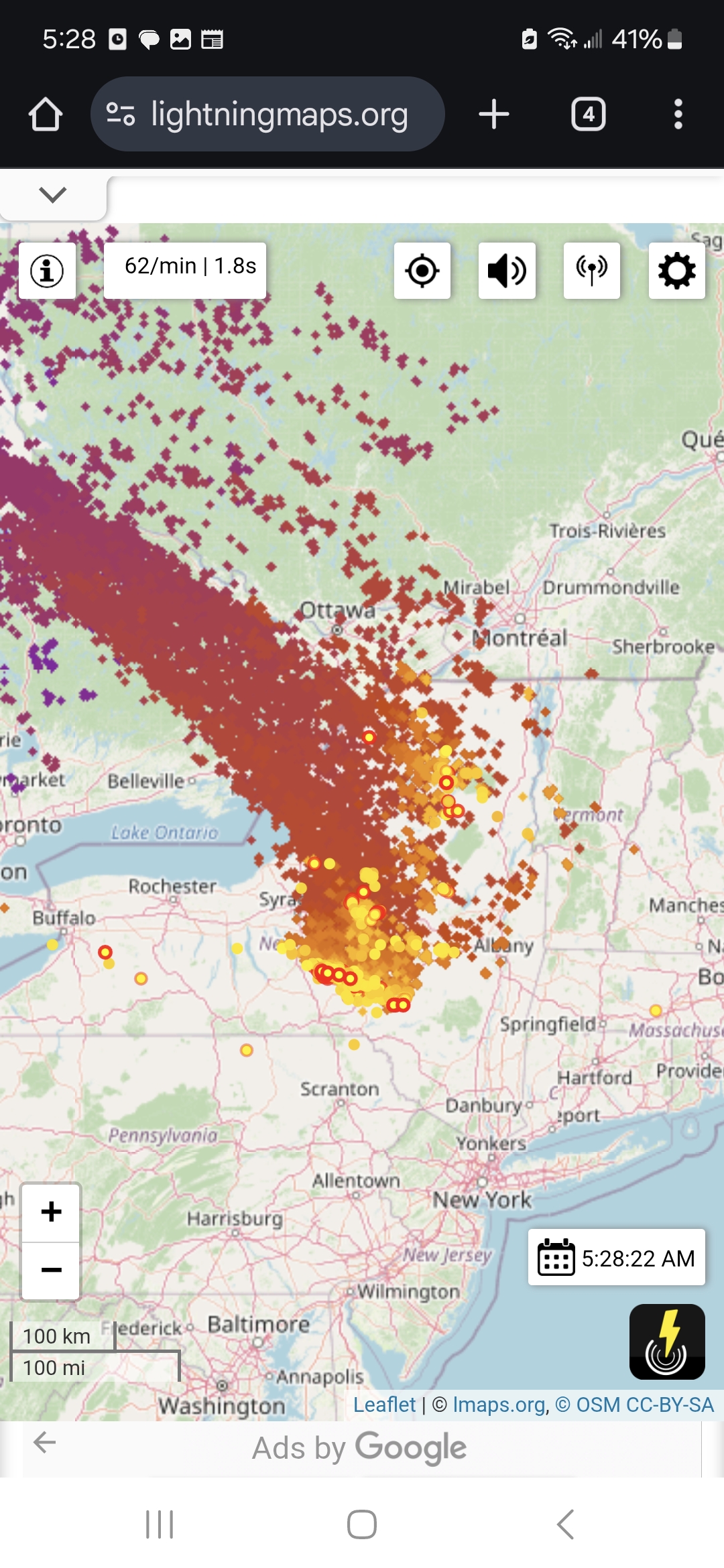
I'm driving at the moment. You can't check but something out. There is going gangbusters at the moment.
-
I'm picking up on abnormally, powerful strokes on my am radio frequency at the moment
-
Continuous thunder just off to my wsw
-
 2
2
-
-
4 hours ago, Voyager said:
So help me understand...
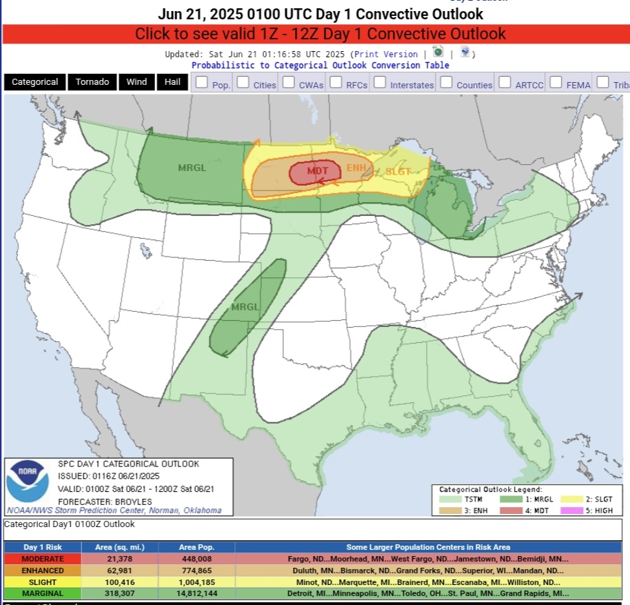
Where did this crap come from that no one saw coming a few days ago? We were supposed to finally have a dry weekend and multiple rain-free days. What happened?
I already mentioned this also this morning.
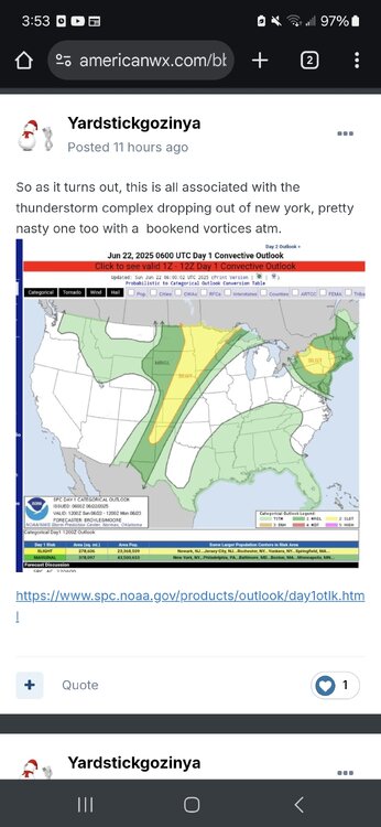
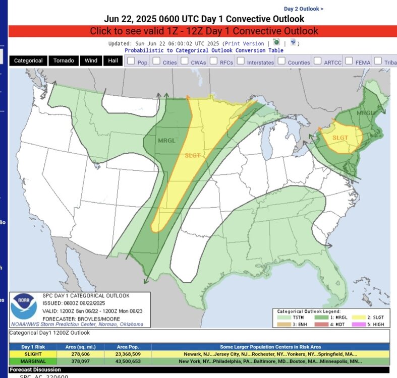
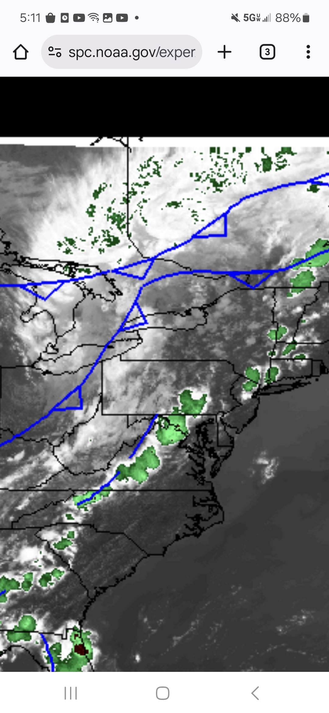
https://www.spc.noaa.gov/products/outlook/day1otlk.html
-
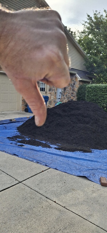
When you have $600.00 mulch piles that can run rivers of black dye all over people's property surprises suck.
-
I wasn't surprised but that's nothing new.
-
On 6/20/2025 at 5:56 PM, Yardstickgozinya said:
Even though there's really no storms in the forecast I noticed Spc keeps us in the convective outlook the next three days.
Lol
-
-
This pattern seems ripe for a good old derecho series in parts of the US this week .
-
1
-
-
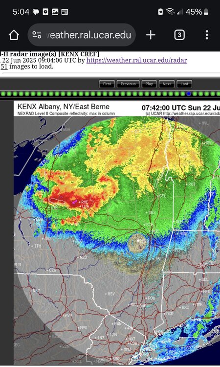
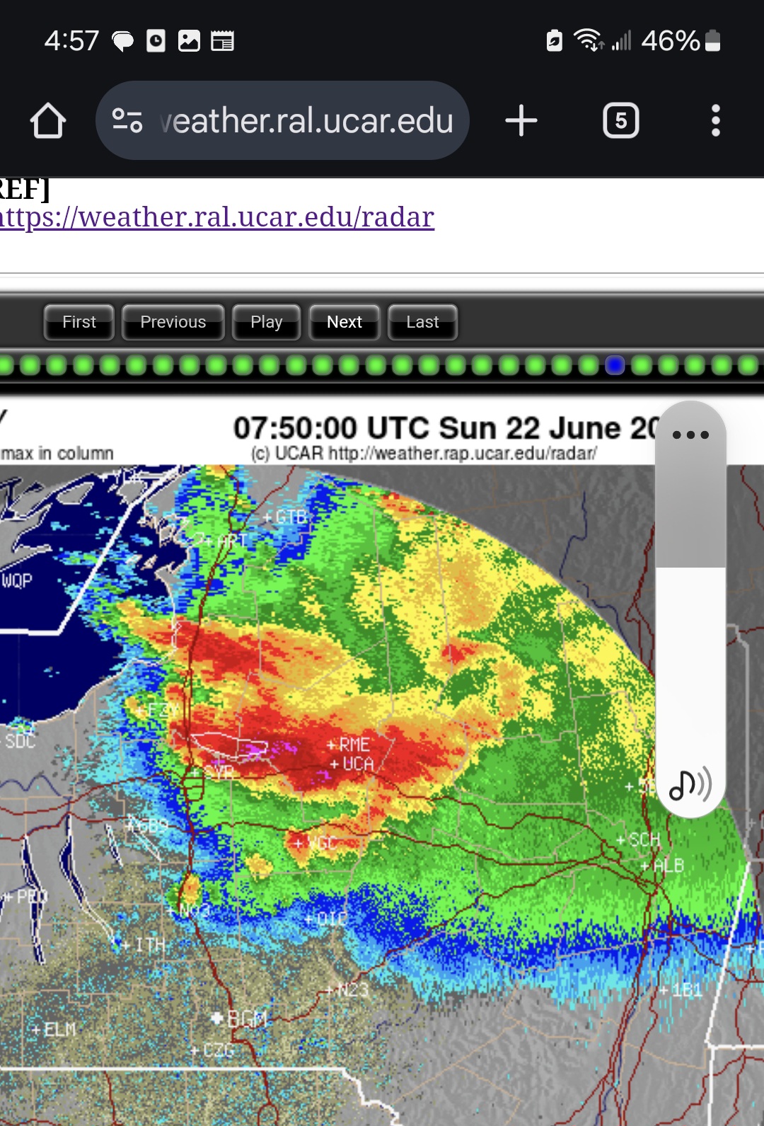
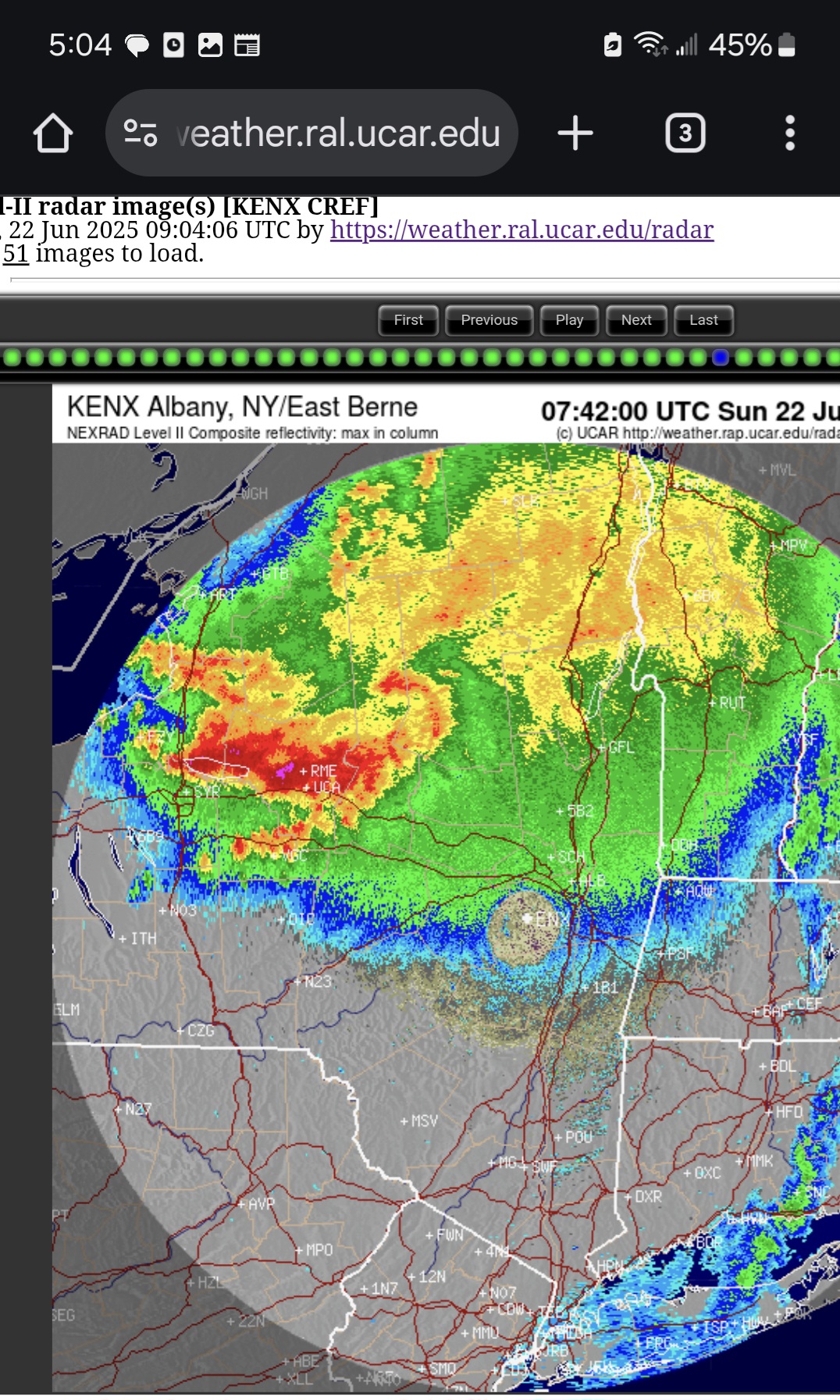
Nice bookend vortices and warm air feed with hail cores throughout its life cycle.
-
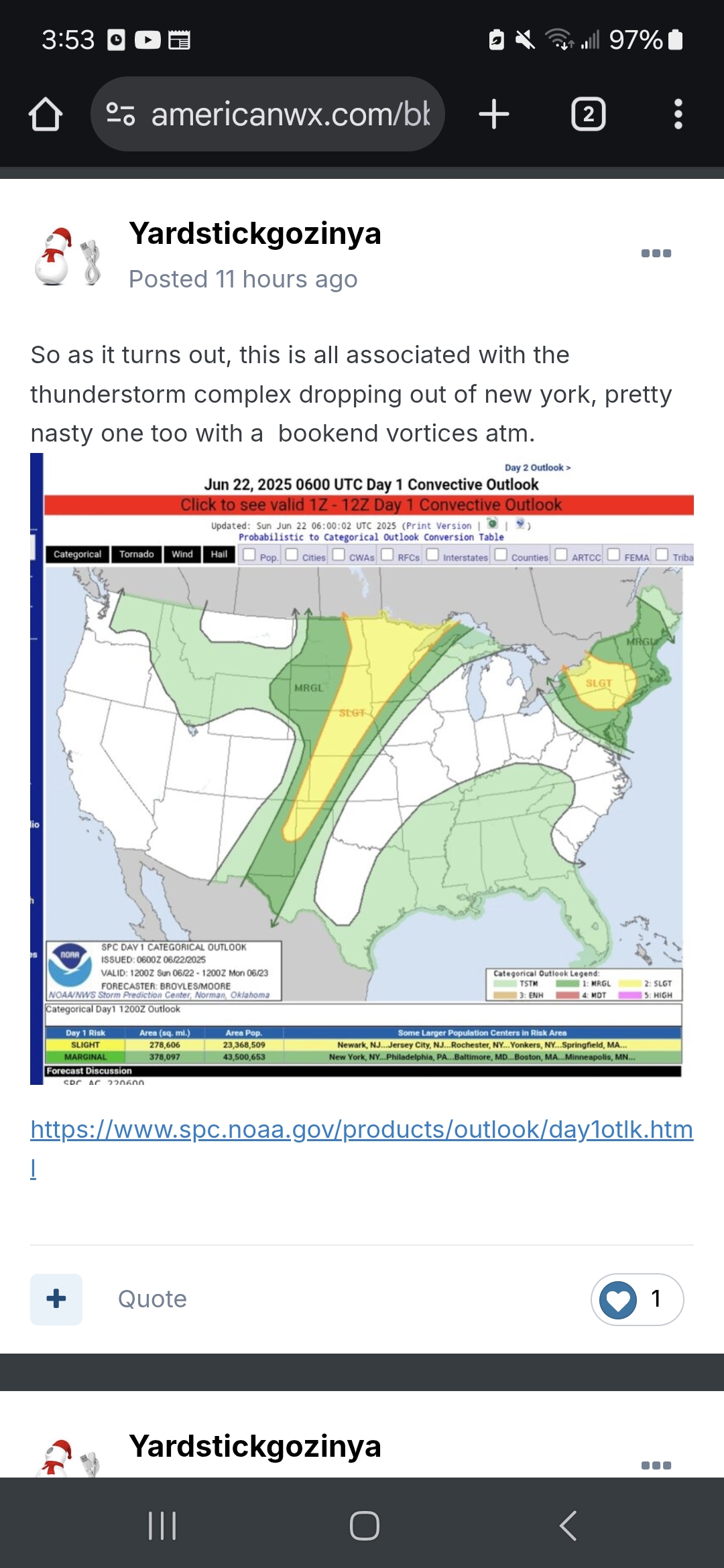
So as it turns out, this is all associated with the thunderstorm complex dropping out of new york, pretty nasty one too with a bookend vortices atm.
-
1
-
-
Always exciting to see how these heat waves will end.
-
I imagine we'll see a few days of very high cape with unbreakable Inversions in the week ahead.
-
4 minutes ago, Yardstickgozinya said:
It was very close on previous outlooks. as mentioned yesterday spc keeps the chances alive but slim untill Monday.
My guess is s SPC put that In place just incase anything does managed to break the cap in the afternoon.
-
27 minutes ago, Itstrainingtime said:
MRGL risk of severe thunderstorms tomorrow. That came out of nowhere.
It was very close on previous outlooks. as mentioned yesterday spc keeps the chances alive but slim untill Monday.
-
Extreme Heat Warning
URGENT - WEATHER MESSAGE
National Weather Service State College PA
302 AM EDT Sat Jun 21 2025

PAZ036-056-057-059-063>066-220800-
/O.UPG.KCTP.XH.A.0001.250622T1500Z-250626T0000Z/
/O.NEW.KCTP.XH.W.0001.250622T1500Z-250626T0000Z/
Franklin-Perry-Dauphin-Lebanon-Cumberland-Adams-York-Lancaster-
Including the cities of Chambersburg, Lebanon, Newport,
Gettysburg, Lancaster, Harrisburg, Hershey, York, and Carlisle
302 AM EDT Sat Jun 21 2025

...EXTREME HEAT WARNING IN EFFECT FROM 11 AM SUNDAY TO 8 PM EDT
WEDNESDAY FOR THE LOWER SUSQUEHANNA VALLEY...

* WHAT...Dangerously hot conditions with heat index values over 105
  expected for the Lower Susquehanna Valley.

* WHERE...Adams, Cumberland, Dauphin, Franklin, Lancaster, Lebanon,
  Perry, and York Counties.

* WHEN...From 11 AM Sunday to 8 PM EDT Wednesday.

* IMPACTS...Heat related illnesses increase significantly during
  extreme heat and high humidity events.

* ADDITIONAL DETAILS...Heat index values and the associated risk of
  heat-related impacts will be highest on Monday and Tuesday.

PRECAUTIONARY/PREPAREDNESS ACTIONS...

Drink plenty of fluids, stay out of the sun, and stay in an
air-conditioned room.

Check up on relatives and neighbors, and provide pets with adequate
water and shelter from the sun.

Extreme Heat can be life-threatening among at-risk populations, such
as children, the elderly, and those with pre-existing health
conditions.

In addition to the daytime heat, overnight low temperatures will
also be very warm and oppressively muggy.

&&

$$
-
1
-
-
-
15 hours ago, Itstrainingtime said:
Ain't no way I'd be out on the water with a storm that imminent. But great pictures nonetheless!
I changed my original reply because after I thought about it I realized that It came off as being very belittling to Mount Joy Snowman . I truly didn't intend it to be . He's seems like a stand up guy. I'm an idiot what can I say.
-
Even though there's really no storms in the forecast I noticed Spc keeps us in the convective outlook the next three days.
-
I hope disturbance droppingin out of the nw dies ? Not today please.

-
Bad day for storms locally but a good day for learning and mulching. Atleast now that I found some of these tools it's much harder for someone to say it's black when it's really white, theoretically of course lol. Not that anyone here would do such a thing.
-
4 hours ago, Itstrainingtime said:
It will be interesting to see what happens with that stuff in western PA. Light to moderate rain continues to backbuild down this way, no opportunity to clear out for the foreseeable future.
I thought you said it would be interesting lol. There was definitely a lot of anx among our local forecasters yesterday about exactly where storms would Initiate. I said yesterday my hopes were a little different than my expectations but i'm not afraid to share them both.
-
-
Looking a the IR dose put there idea of that in question.

Central PA Summer 2025
in Upstate New York/Pennsylvania
Posted