MDScienceTeacher
-
Posts
332 -
Joined
-
Last visited
About MDScienceTeacher

-
The February 22-23 Late Season Miracle: JV Disco/Banter Thread
MDScienceTeacher replied to bncho's topic in Mid Atlantic
Can we make @psuhoffman do a zoom call (radio show) again? -
2/22-23 "There's no way..." Storm Part 2
MDScienceTeacher replied to Maestrobjwa's topic in Mid Atlantic
Dude you should be careful. where you understand the crazy bust boom potential of this storm and know to take your forecast with a grain of salt, your coworkers could be looking to you as the "wiz weather geek" that always "gets it right".. and for all we know some poor schmuck decided to move forward with a party or some big plans based on the fact that "2-4 is nothing" then Sunday night comes and he is stranded in his car on route 50 under a blizzard warning! -
2/22-23 "There's no way..." Storm Part 2
MDScienceTeacher replied to Maestrobjwa's topic in Mid Atlantic
Yup it goes to show just how much people do not trust the gfs anymore. Three years ago this place would have bonkers for 5 days straight even without the euro being on board. -
Feb 22nd/23rd "There's no way..." Storm Thread
MDScienceTeacher replied to Maestrobjwa's topic in Mid Atlantic
I havent been taking it seriously until literally just now waking up and seeing the 6z.. it is good to see you on board.. I guess i am in.. its only 36 more hours of emotional investment at this point.. why not? -
Feb 22nd/23rd "There's no way..." Storm Thread
MDScienceTeacher replied to Maestrobjwa's topic in Mid Atlantic
And then maybe cut that in half from there considering the overall "there is no fucking way this is happening" factor.. but hey.. if is snows 8-10 inches, I would be more than happy. -
Feb 22nd/23rd "There's no way..." Storm Thread
MDScienceTeacher replied to Maestrobjwa's topic in Mid Atlantic
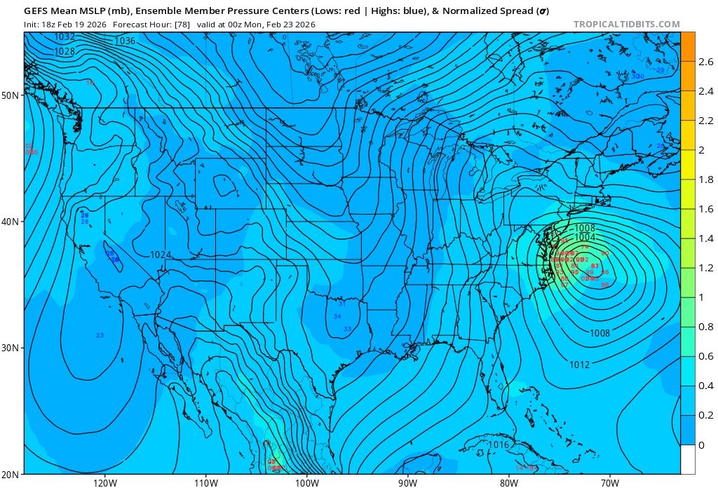
Not sure if anyone posted this or not but the individual members really dont get any better than this.. the vast majority are west of the mean.. maybe too much?
-
Feb 22nd/23rd "There's no way..." Storm Thread
MDScienceTeacher replied to Maestrobjwa's topic in Mid Atlantic
Of course the Euro gonna troll -
January 24-26: Miracle or Mirage OBS Thread!
MDScienceTeacher replied to Jebman's topic in Mid Atlantic
Thx! I am glad I didn’t change my trip. -
January 24-26: Miracle or Mirage OBS Thread!
MDScienceTeacher replied to Jebman's topic in Mid Atlantic
How much would you say you have? I’m in LA right now and I just got a video for my son in Ellicott city and it honestly just looks like 2 1/2 inches and he says it’s sleeting already. I am awfully skeptical of all these six and 7 inch abs. -
January 24-26: Miracle or Mirage JV/Banter Thread!
MDScienceTeacher replied to SnowenOutThere's topic in Mid Atlantic
Disaster -
January 24-26: Miracle or Mirage JV/Banter Thread!
MDScienceTeacher replied to SnowenOutThere's topic in Mid Atlantic
Talking about this one? WB 18Z EURO If this is the entire storm then and this pans out.. this would be a bust. -
It actually makes sense. the ai models are just glorified analogue forecast. the both use advanced ML techniques to train on a enormous data sets. Both models are probably trained on more or less the same data and probably use similar techniques
-
I want @Ji to chime in on this one as he is the SME on this topic. If I had to guess (especially given the major rug pulls over the last 10 years) almost all of them were lost in 72-120 range.
-
@Ji do you have any historical data on when we usually see a major shift in the global models that typically lead to a fundamental change in snowfall forecast for our region? 48-72 hr range? 72-120 hr range? 120-200 hr range?
-
Sleet is possible in any of these big storms. The warm layer can find its way in.. but the cold air is pretty well entrenched with this system and and I am not quite seeing much of the negative tilt in upper levels that would lead to warm air intrusion. This is also the same reason why we are not seeing the HECs level QPF totals like we saw in 03. Obviously this can change.. but this looks more like snow than anything else for the DC metro region.