

DarkSharkWX
-
Posts
695 -
Joined
-
Last visited
Content Type
Profiles
Blogs
Forums
American Weather
Media Demo
Store
Gallery
Everything posted by DarkSharkWX
-

Jan Medium/Long Range Disco: Winter is coming
DarkSharkWX replied to stormtracker's topic in Mid Atlantic
-
Jan Medium/Long Range Disco: Winter is coming
DarkSharkWX replied to stormtracker's topic in Mid Atlantic
kuchera more than 10:1??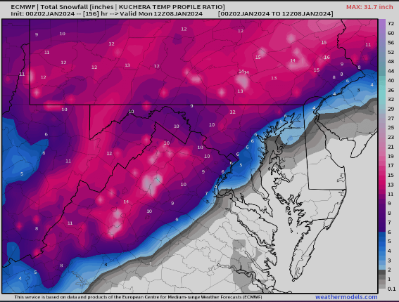
-
Jan Medium/Long Range Disco: Winter is coming
DarkSharkWX replied to stormtracker's topic in Mid Atlantic
-
Jan Medium/Long Range Disco: Winter is coming
DarkSharkWX replied to stormtracker's topic in Mid Atlantic
-
Jan Medium/Long Range Disco: Winter is coming
DarkSharkWX replied to stormtracker's topic in Mid Atlantic
one thing i noticed on the gfs was that our vort over OK digs more and shunts it N, id assume its a part of why we saw a N shift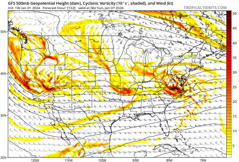
-
Jan Medium/Long Range Disco: Winter is coming
DarkSharkWX replied to stormtracker's topic in Mid Atlantic
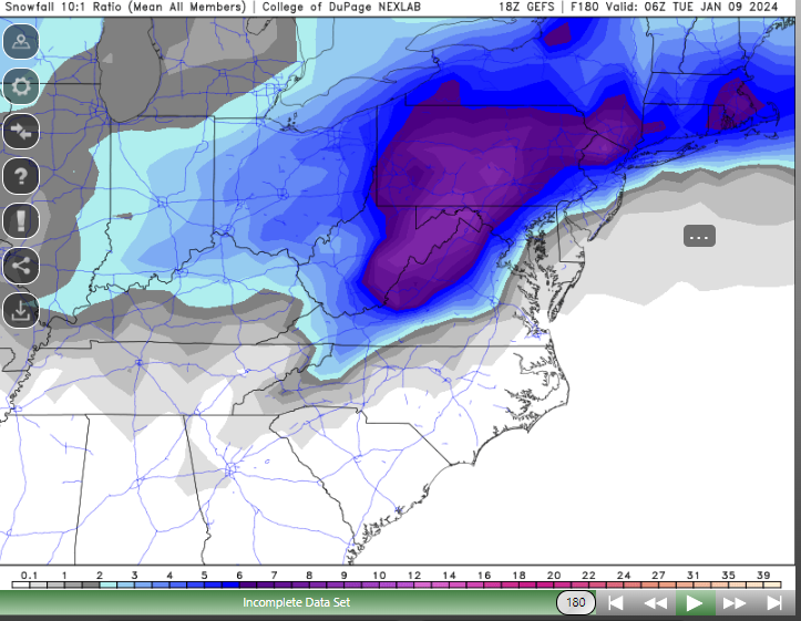
here is dynamic slr/cobb ratio(takes in account all layers of atmosphere + rates better)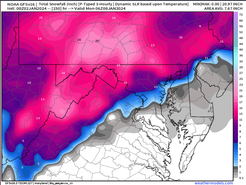
-
Jan Medium/Long Range Disco: Winter is coming
DarkSharkWX replied to stormtracker's topic in Mid Atlantic
no cmc shifted S, still a way to go but better than last run -
Jan Medium/Long Range Disco: Winter is coming
DarkSharkWX replied to stormtracker's topic in Mid Atlantic
This isnt even that bad -
Jan Medium/Long Range Disco: Winter is coming
DarkSharkWX replied to stormtracker's topic in Mid Atlantic
yeah i have weathermodels bc it has most of the weatherbell stuff for a good amount cheaper, there is a lot of cool stuff and it usually comes out at around the same speed including euro/eps offruns -
Jan Medium/Long Range Disco: Winter is coming
DarkSharkWX replied to stormtracker's topic in Mid Atlantic
if anyone is interested -
Jan Medium/Long Range Disco: Winter is coming
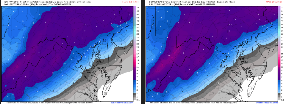
DarkSharkWX replied to stormtracker's topic in Mid Atlantic
EPS slightly S, more wetter euro control SE shift -
Jan Medium/Long Range Disco: Winter is coming
DarkSharkWX replied to stormtracker's topic in Mid Atlantic
models are cooking for the 7th, GEFS/EPS/GFS/EURO bombs, esp NW of 95 -
Jan Medium/Long Range Disco: Winter is coming
DarkSharkWX replied to stormtracker's topic in Mid Atlantic
-
Jan Medium/Long Range Disco: Winter is coming
DarkSharkWX replied to stormtracker's topic in Mid Atlantic
yeah ive been seeing that signature on all the ensembles when looking at precip anomaly maps thats prob gonna help us here -
Jan Medium/Long Range Disco: Winter is coming
DarkSharkWX replied to stormtracker's topic in Mid Atlantic
GEFS is insane -
Jan Medium/Long Range Disco: Winter is coming
DarkSharkWX replied to stormtracker's topic in Mid Atlantic
gefs follows op, stronger SE canada confluence as well as stronger SW, therefore stronger HP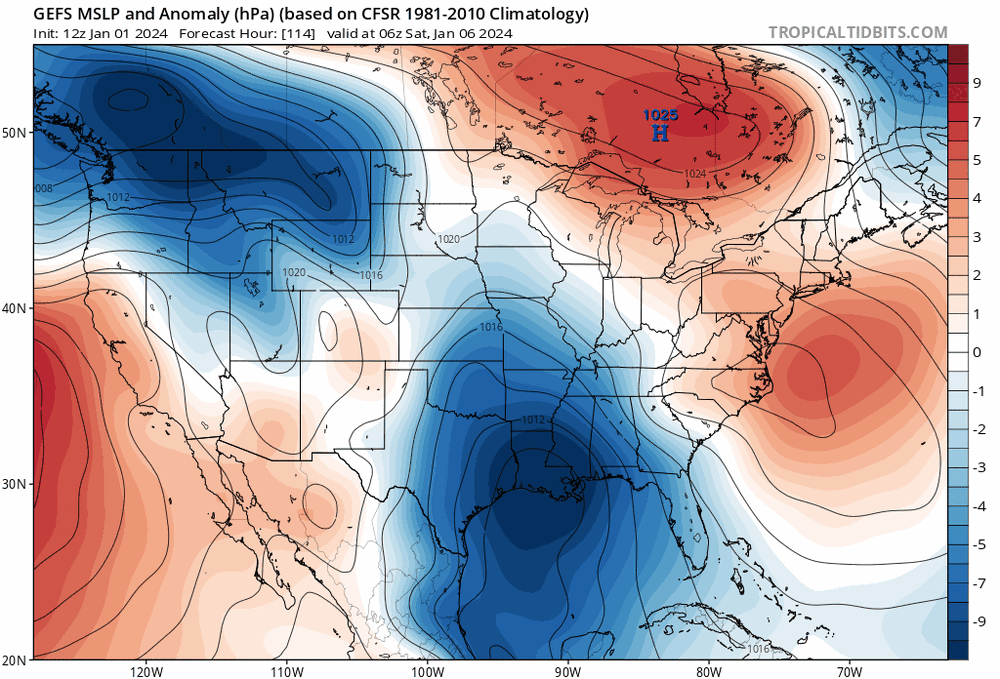
-
Jan Medium/Long Range Disco: Winter is coming
DarkSharkWX replied to stormtracker's topic in Mid Atlantic
there is a bit of similarity w the track -
Jan Medium/Long Range Disco: Winter is coming
DarkSharkWX replied to stormtracker's topic in Mid Atlantic
its not that great but pattern and storm evolution so it says the top analog is feb 05-06 2010 bc of indicies values and similarity in storm -
Jan Medium/Long Range Disco: Winter is coming
DarkSharkWX replied to stormtracker's topic in Mid Atlantic
high placement has been very consistent the last 3-4 runs on the GFS, gotta love 50/50s -
Jan Medium/Long Range Disco: Winter is coming
DarkSharkWX replied to stormtracker's topic in Mid Atlantic
just for fun cips analogs for the 7th -
Jan Medium/Long Range Disco: Winter is coming
DarkSharkWX replied to stormtracker's topic in Mid Atlantic
looks like 0z rn w snow mean -
Jan Medium/Long Range Disco: Winter is coming
DarkSharkWX replied to stormtracker's topic in Mid Atlantic
that works -
Jan Medium/Long Range Disco: Winter is coming
DarkSharkWX replied to stormtracker's topic in Mid Atlantic
is there a NW trend mechanism set in a nino like the SER in a nina? the confluence could trend weaker in the short range and go N but thats not set in stone and dependable on like a NW trend in a nina 2019 had a few NW trends but it was the only nino i tracked and it didnt really couple properly so i was j wondering cause i hear a lot of people being certain of a NW trend in the short range -
Jan Medium/Long Range Disco: Winter is coming
DarkSharkWX replied to stormtracker's topic in Mid Atlantic
-
Jan Medium/Long Range Disco: Winter is coming
DarkSharkWX replied to stormtracker's topic in Mid Atlantic
6" snow mean on EPS alone from this storm not done snowing


