DarkSharkWX
-
Posts
695 -
Joined
-
Last visited
Content Type
Profiles
Blogs
Forums
American Weather
Media Demo
Store
Gallery
Everything posted by DarkSharkWX
-

- 484 replies
-
- 10
-

-

-
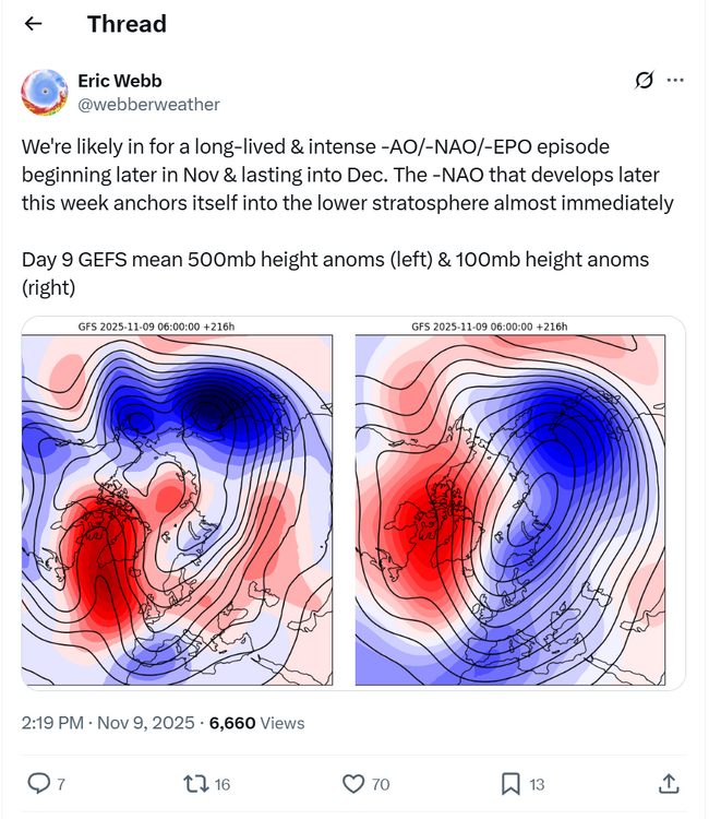
2007-08 or 2008-09? it's very hard to isolate the effect of the -IOD given covariability between IOD and ENSO, but webb tried to do so (for weak to mdt -ENSO using 20cr) and the results were interesting; hints of -NAO/+PNA in early winter then a snap to +NAO and strong PV in feb, sort of exaggerating canonical nina progression(also similar to -QBO/high solar -ENSO) https://twitter.com/webberweather/status/1984271391596916942
-
where do you get the EMI index/EMI forecasts?
-
webb and others have said that the current subsurface/sst profile is similar to last year Ninas which transitioned into ninos the next year
-
2017-18 honestly seems like a pretty good analog both within the tropics and with QBO having a -QBO adds more variability for the location of the aleutian high as it is more dependent on tropical forcing(-QBO favors active MJO due to increased instabillity in the UTLS b/c of cooler temps as well as enhanced cloud radiative feedbacks) in these type of +TNH cluster winters the subsurface is suprisingly weak and east based; the IPWP is currently at 150E but given the MJO expected to traverse into the pacific, it could nudge it eastward, since its already decently close to the surface, especially if it stays coupled with other seasonal waves(eq. rossby waves/kelvin waves) as it is right now in the IO. on a larger scale, it would be interesting to see if the WWB associated with the MJO pass could trigger a DKW which could start wrapping up the nina, though this would obviously take time and multiple passes and wouldn't mean anything of significance for the upcoming winter.
-
https://twitter.com/WxTca/status/1979617306818003406
-
if the MJO makes it to the west pacific(which, it shouldn't have too much trouble doing so) then the IPWP will be pushed further east in addition to upwelling some of the heat in the subsurface
-
i agree... continuing into the start of nov a lot of guidance has the -NAO being quite persistent (even if its far out) which would make sense given the evidence that has been portrayed, Paul Roundy said that november would likely be the best month to curtail the SER, with the shift to more SER being sometime in january
-
2021-22/2005-06 were pretty decent, 1995-1996 was obviously really good, and 2017-18 was generally cold/snowy for the east coast we just got really unlucky that year
-
imo the -QBO is slightly worse for us since we'll get more southeast ridging in general(since convection will be more centered around the equator, more poleward convection would also push the pattern more poleward), however, it also means more active/stronger MJO, as well as a weaker PV earlier on, so that could help overwhelm any other subseasonal factor in providing good patterns even if brief if MJO propagates to favorable phases(which, so far, it looks decently good to do so) probably a decent amount better for new england/interior northeast since they are a lot less sensitive to SER, and a lot was very suppressed for them for a good chunk of the winter
-
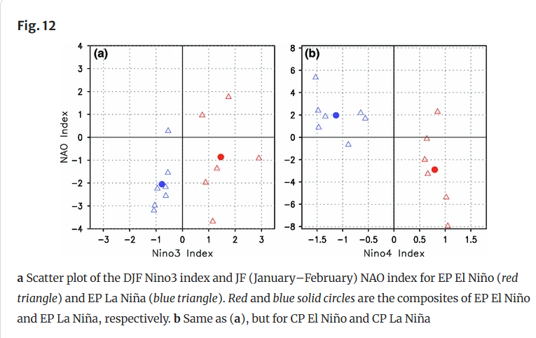
to which statement (assuming both) IOD's effect really depends on strength/location of ENSO... a study i read the other day about CP/EP ninas and the subsequent impact on NAO saw that CP ENSO had statistically significant correlation(SSTA between 180-150W) to either +NAO/-NAO depending on if it was cp nina/nino respectively, but the correlation for EP ninas/ninos was too weak to discern anything as concrete
-
this is really interesting b/c if im not mistaken IOD/IO forcing has the highest correlation to +WPO, so you wouldn't think that it would exactly be favorable for NAO maybe through stratospheric reflection events?
-
it will probably depend where the center of the IPWP ultimately ends up(east is more poleward ridging, west would be more towards an Aleutian ridge) as well as how strong the Nina gets/how much it develops. So far the cold pool in the subsurface has been surfacing with easterlies which is leading to the Nina getting pretty established, but it is still ep in origin. the IPWP has great backing from the subsurface, all the way to the dateline too, so that would likely put a cap on its development closer to the dateline
-
isnt this normal/expected (for the IPWP) in +TNH cluster winters? although you are certainly right with the warmest waters being between 140-160E, -QBO increases instability in the UTLS which should fuel more active/stronger convection on the equator, but since the Nina is east-based/not very strong, theoretically, MJO propogation should be able to make it into more favorable phases at times https://journals.ametsoc.org/view/journals/clim/36/3/JCLI-D-22-0010.1.xml
-
early in January? wouldn't that be later on in mid-late january
-
while this is true, the current ssta configuration in the tropics is favorable for MJO propagation with a warm pool in the west pacific that's backed by the subsurface along -QBO and an east based nina, so we should still be able to get a decent amount of poleward ridging episodes -QBO and solar max should cancel each other out but in general could be more open to -NAO/-AO episodes early on in winter(HT relationship for (+QBO/solarmax) says weak PV start, strong PV mid-late winter) I do think that we see more southeast ridging this winter in general though
-
why/how/in what way does ace matter for winter? i've seen a few people mention it before but its not widely described
-
it hasn't meant much since the PDO flipped negative long-term in the early 2020s
-
https://journals.ametsoc.org/view/journals/clim/36/3/JCLI-D-22-0010.1.xml Shouldn't have too much of an issue with getting propogating MJO especially combined with the -QBO which will help increase instabillity in the upper tropopause/lower stratosphere, +SSTA over 140-175E will help enhance moisture convergence in the leading phase/wave of the MJO
-
doesnt eastern IO forcing have the highest correlation to +WPO?
-
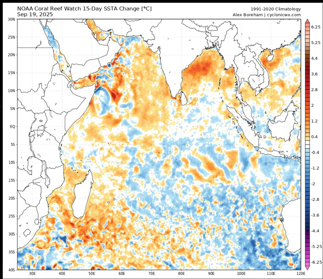
decent amount of bob warming recently
-
i'm pretty sure this is the one that evb uses, https://www.bom.gov.au/climate/enso/indices.shtml?bookmark=iod
-
RONI should be <-0.5, global SSTA is near +0.5
-
for me the highest storm in 2014 was the overpreforming vday storm with ~19" here, 20-26" in the ridges north of me
-
i mean we still probably will get a good period of HL blocking w/ -EPO and +PNA its just that theres going to be more SER (especially before/after good periods) with a more developed nina since -QBO relates to more active MJO