

DarkSharkWX
-
Posts
695 -
Joined
-
Last visited
Content Type
Profiles
Blogs
Forums
American Weather
Media Demo
Store
Gallery
Everything posted by DarkSharkWX
-
EPS looks a bit weaker but same wrt to temps and track, i think it will hold gen
-
think GAI and westward/northward has a decent shot of plowable snow
-
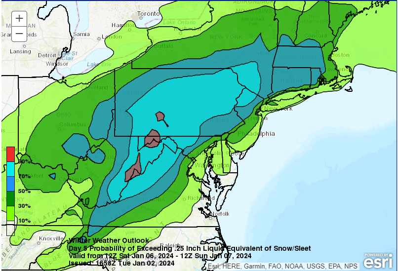
6-10 snowdepth
-
-
cmc amazing too just NW of dc
-
great run
-
nmore amped and more confluence
-
gefs is way colder 850 0C line is SE of st marys
-
75 mile shift S, even dc stays all snow
-
CMC absolutely crushes us, S of last run w more conflunece GFS noticeable shift more confluence did something get sampled?
-
iqr, 50th, 75th, 90th
-
-
thats j cause less precip it overall held and is still nice
-
850 seems SE of DC whole run
-
EPS looks similar to 12z but weaker and SE
-
and 5 mb lower 50/50
-
im suprised, some of the indies have extremely large hits, im interested to see what their handling of the SW US shortwave is and how everything gets affected by it wish there was a way to do so but it appears not sadly
-
EPS holds generally if anyone cares
-
that completely changes the setup sadly, we also see the dual jet signature go away on euro
-
its just the new vort in the SW/Central US that digs and fucks up everything, not only induces height rises and make the low go north but also flattens out the storm and makes it weak, not as simple as "NW of low snows" anymore sadly good news is this energy is over the aleutians rn, i would give it some time before canceling this but trends are unfavorable rn ill admit
-
https://sites.gsl.noaa.gov/desi/?chart=x4d&lat=40&lon=-105&theme=dark&dset=NBM4.1-CONUS&clusHghlgt=true&x4dGrid={"HREF"%3A{"url"%3A[40.5%2C-100%2C388%2C270]}%2C"NBM4.1"%3A{"url"%3A[39.096%2C-76.637%2C"450"%2C"315"]}} site to this if anyone wants it btw, chance of 5" below(WSW criteria)
-
-
much better this run
-
CMC crusher NW of 95
-
thermals are wrong, it shows low-mid 20s in like SNE and rain


