

Stormchaserchuck1
-
Posts
3,790 -
Joined
-
Last visited
Content Type
Profiles
Blogs
Forums
American Weather
Media Demo
Store
Gallery
Posts posted by Stormchaserchuck1
-
-
Ravens don't wobble in updated super bowl betting odds.. 1/5.5, greater than before the season started (they were 1/6.5) Part of that is because of how bad the division is:
Pitt 1/66 odds
Cincy 1/125 odds
Browns 1/500 odds
-
18 hours ago, snowman19 said:
And on the PAC side, this -PDO cycle has been much stronger than the last one (1940’s-1970’s). I’ve seen a few articles blaming the record low arctic sea ice on this -PDO cycleI would think warmer water in the Gulf of Alaska and Bering Strait would be a cause of more arctic ice melt, which is more +PDO... but the arctic ice melt has completely gone bare on the Pacific side of the Arctic circle, and the PDO has gone to new record low levels during and after that time, so something may be connecting them.. although maybe not directly
-
 2
2
-
 1
1
-
-
I'm more down on the D-coordinator. You can't have that much talent on defense and be so bad.. I'm talking about the secondary. I think it's bad play calling. Last season we started 31st then finished 1st in the last 8 games, so hopefully this year is the same.. but I think we probably need a new defensive coach, they look like they are always lagging behind the offense instead of creating their own momentum
-
Justice Hill doesn't look as good as he did the past 2 years. Maybe he didn't practice in the offseason or something. Good thing we have Mitchell!
-
 1
1
-
-
Lions played better. Hopefully Ravens can get their defense together in time for the playoffs.. we have 5 pro bowlers on defense. When the Lions were 4th and 3 from the 5 and the CBs were playing in the end zone, I was like huh?? They did a short hook for the 1st down.
Passing game looks really good though, with DeAndre Hopkins looking like a great pickup. And Likely is very underrated too, when he comes back.. offense is pretty loaded.
-
4th and 3, why are they playing 10 yds off the WR's? Absolutely horrible defensive play calling.
-
18 hours ago, snowman19 said:
@Stormchaserchuck1 IMO we are on the verge of finally going into a -AMO cycle
I made this graph last year, it's a smoothed out AMO index since it went positive in 1995. It appears that we still seem to be in a rising phase, over the long term.
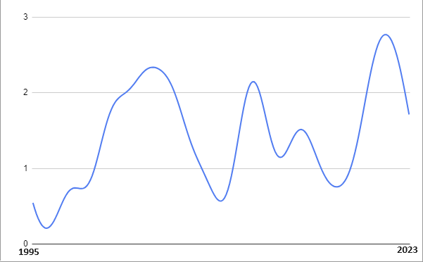
Also, the NAO has been very positive May-Aug, just like last year. Such +NAO in the warm season has a -0.3 SSTA correlation in the south-central Atlantic. A lot of the cool water this year is because of such a strong +NAO... It's been positive 8 of the last 9 months. If the NAO had been negative 8/9 months, you'd be seeing some very warm SSTAs in the Tropical Atlantic, and probably more activity this hurricane season.
-
1
-
-
The newly released CPC Winter outlook is colder than 90-95% of what they've put out in the long range for the last 10 years, for the CONUS.
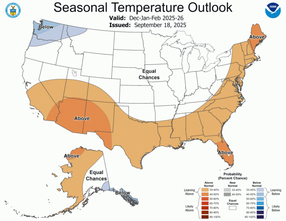
The NW, US is an interesting forecast, because the Euro, CANSIPs, and other seasonal models are above average there.
-
3
-
-
It's kind of silly to see the H5 change the SSTAs and then everyone go with what the SSTs show. For the next 10 days, we have a Gulf of Alaska low and Aleutian ridge.. the PDO is going to go pretty negative again. but these are the symptom, not the cause. It would actually be easier to roll forward PNA patterns/analogs instead of always looking at SSTs, because SSTs are actually always a few weeks behind. MJO/ENSO waves move the N. Pacific pattern, which in turn move around the SSTAs. Kelvin/Rossby waves are probably as close as your cause/main drivers. There have been a few more rossby waves with developing La Nina, which will probably create more -PNA tendency going through the Fall (maintaining a -2 to -3 PDO). Watch the ENSO subsurface, if cold water -200m strengthens, it's more -PNA/-PDO tendency, and warmer water there is more +PNA/+PDO. The gravity waves at the surface move these subsurface water anomalies.
-
1
-
 1
1
-
-
1 hour ago, GaWx said:
AAM says solid La Niña like for next month:
It might be hard to sustain a +PNA this Winter.
-
2
-
1
-
-
8 minutes ago, Interstate said:
Is this not a tropical system... it looks like an eye on radar just off the coast of VA.
Looks tropical to me. It probably does have a warm core, given the time of year and location.
-
9 hours ago, snowman19 said:
Still looks on target for a late month and October flip (Chuck’s -PDO/-ENSO link for October) to a warmer than normal pattern, also continued very dry. Once we get into October, if the dryness continues and it looks like it will, we will be approaching serious drought conditions
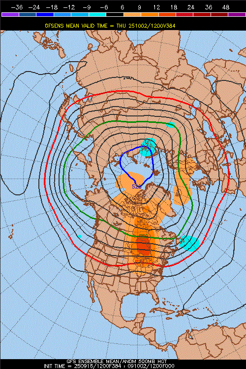
Long range 12z GEFS at 384 has a pretty strong ridge setting up for the first few days of October
NAO is also turning negative this September after being positive every month since last January.. this same thing happened last year, where the +AO/+NAO that was present all Summer long broke in September.
-
2
-
-
Hmm, I think global warming coincides with less low level clouds and clouds in general. This is why it was always surprising to see global precipitation increase, and precipitable water. It makes sense that warm/dry would be the trajectory, but for the last few decades more moisture has happened by a lot.
-
1
-
-
Ravens beat the spread again. They are 2-0 vs the line this season. These are the same betting odds that currently has them tied for #1 super bowl favorite.
-
Joe Burrow out for possibly the season, at the least 3 months. Ravens odds of winning the division goes up significantly.
-
Ravens next 4 games are all against playoff teams.. a combined regular season record of 50-18 a year ago.
-
Packers super bowl betting odds really jumped over the last 2 weeks. They were 1/20, then traded for Parsons and went to 1/14, to now 1/6.5.
1. Bills
2. Packers
-
1 hour ago, anthonymm said:
Yes it does.
The top 5 analog years are all in the last 5 years. How have you done in the last 5 years?
The next two weeks should have a trough in the NE N. Pacific. If people are freaking out about warm SSTAs there, there really shouldn't be a strong, persistent trough developing but the atmosphere comes first and SSTs 2nd. In 2 weeks the warm water in the Gulf of Alaska should cool..
-
1
-
-
5 hours ago, 40/70 Benchmark said:
I think it's one of the more helpful teleconnectors in terms of individual storms, but I would take the -EPO for starters during a given season....getting a vortex over AK is the kiss of death for any season.
+PNA has high coastal low pressure correlation. So when we don't get that for many years people think that climate change is permanently changing the pattern lol. -EPO is very underrated just because of how flat central-North America is and a High pressure to the NW can really bring down cold air. +EPO isn't something we've seen much of lately. When it hits temperature forecasts almost always bust higher than expected. That's a pattern that when strong in January can lead to 70s in the Mid Atlantic. The Pacific definitely trumps the Atlantic as far as teleconnection patterns go, anomaly-wise, it goes more W->E vs N->S.
-
1
-
-
7 hours ago, 40/70 Benchmark said:
Depends on how severely positive the WPO is. I think it's important to stop tethering ourselves to these absolute rules because nothing in the atmosphere operates in a vacuum. I think @Stormchaserchuck1put it best...."question everything"-
Yeah things aren't always what they seem.
ENSO subsurface is cooling again with -4c in the central-region
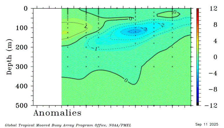
I found this correlates with the N. Pacific pattern most of all ENSO variables. The PNA correlation gets going in November, and has highest correlation in Jan-Feb.. if the cold water in the subsurface continues until then. Subsurface fluxes more than the surface. But we really haven't seen that much Aleutian ridging this year. With all the cold H5 near the Pole lately, a cold season +PNA is actually slightly favored just per the Summer Polar pattern. Will be interesting to see which of those two wins out this Winter.
-
1
-
-
They almost blocked that FG at the end. I don't know how the guy didn't block it actually, he had a completely clear lane to the kicker.
40 points, no INTs, 235 rushing yds and losing lol. The defense has been off since that D-coordinator who is now coach of SEA left. They have like 6 pro bowlers on defense. No excuses it should be that terrible. Buffalo was completing sidelines passes when they needed to.. last play of the half etc. It's pretty easy to defend against a desperate situation you would think...
-
15 minutes ago, snowman19 said:
Lack of eastward MJO propagation, -IOD and persistent strong trades has lead to a deep -AAM and La Niña like regime
We haven't been seeing a big Aleutian ridge though.
It looks like a vortex over the Arctic circle will get down below 4950dm tomorrow! That is probably record breaking, occurring just north of Russia and coming in close to -500dm. These vortexes over the last few weeks have been something, in the last few days of August we also had a sub-5000dm vortex over the Arctic circle. These extremes are similar to like Cuba hitting freezing.
-
1
-
-
The Apr-May SLP pattern in the Atlantic was a giveaway.. something to look at in future years. Pattern never really supported a major warming of tropical Atlantic SSTs.
-
1
-
-
Atlantic (NAO) has slight inverse correlation from October to the Winter
Pacific has a pretty strong direct correlation from October to the Winter, a lot of that is around the PDO, which is strongest in Oct out of PNA/ENSO.
-
1
-
2025-2026 ENSO
in Weather Forecasting and Discussion
Posted
Warmer October still look likely. Long range models have +EPO, which I have stressed is a connected -PDO pattern, strongly, in October. What I mean is the PDO as an independent variable, not connected to 0-time conditions and influenced by them. It's working for the 2nd year in a row, as the PDO has been strongly negative in both of those October's.