mikeeng92
-
Posts
286 -
Joined
-
Last visited
Content Type
Profiles
Blogs
Forums
American Weather
Media Demo
Store
Gallery
Everything posted by mikeeng92
-
Richmond Metro/Hampton Roads Area Discussion
mikeeng92 replied to RIC Airport's topic in Mid Atlantic
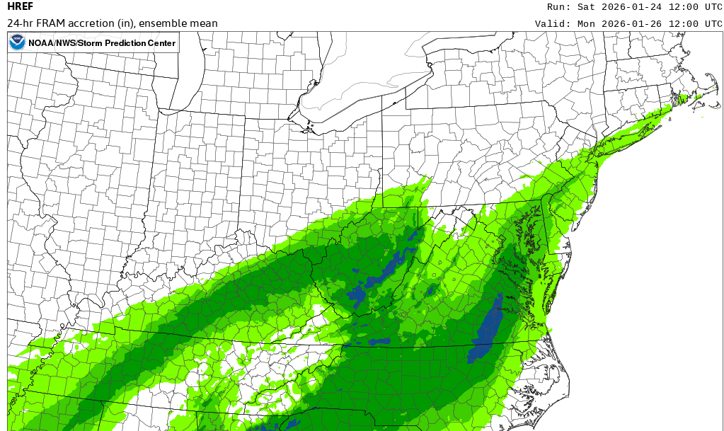
Models look to be targeting the east end of the metro for the worst of the ice. That is .50-.75" of FRAM accretion in the blue. Matches up with other models.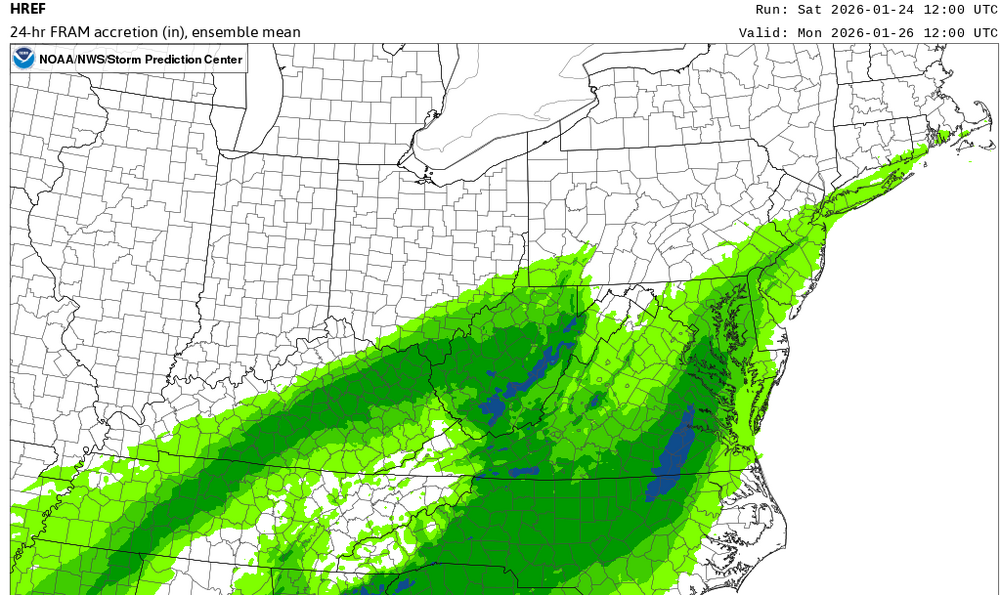
-
Jan 24-26 Weekend Snow and Sleetfest Model Thread Part Tres
mikeeng92 replied to H2O's topic in Mid Atlantic
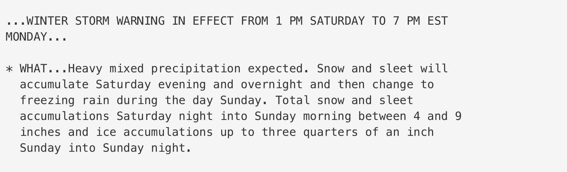
Quite the language from Wakefield: KEY MESSAGES... 1) A devastating winter storm for a large portion of the area will impact the region Saturday afternoon/evening through Sunday night with snow, sleet, freezing rain, and rain expected. These amounts of the combined wintry precip will lead to devastating impacts and widespread power outages and tree damage. Very cold temperatures and windy conditions early next week will lead to long last impacts. -
Richmond Metro/Hampton Roads Area Discussion
mikeeng92 replied to RIC Airport's topic in Mid Atlantic
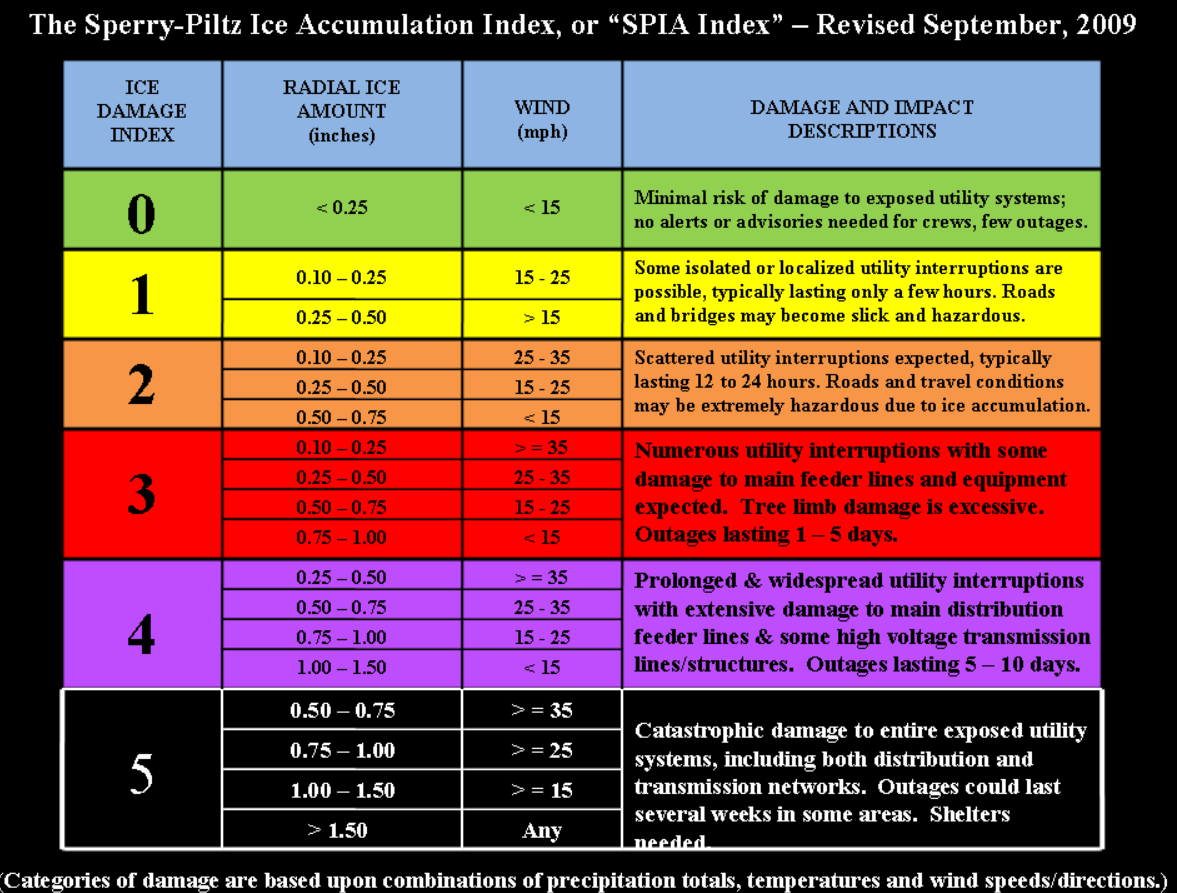
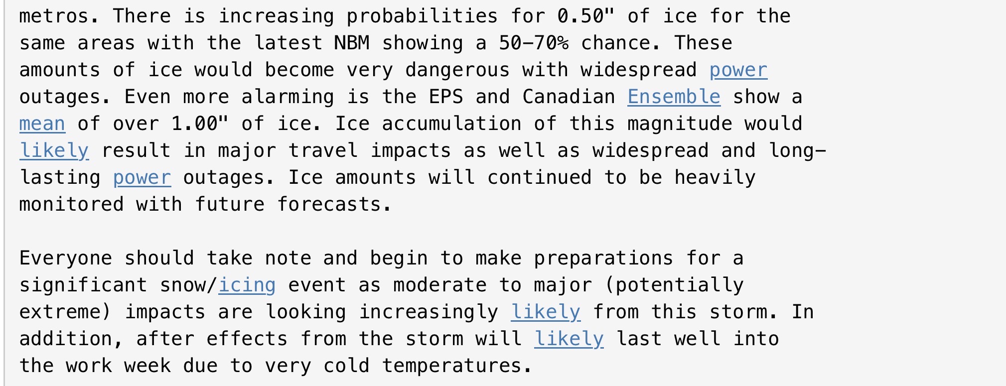
The storm ice totals remain relatively similar to the previous forecast with the highest amounts of up to 0.75" of ice across the south central to Richmond metro areas in addition to 2 to 5 inches of snow/sleet. There has been a slight shift in favoring sleet rather than freezing rain for the far northern counties, but ice totals up to 0.5" of ice is expected, on top of the 4 to 7 inches of snow/sleet. The precip will likely end as another batch of light snow before moving away from the area. These amounts of the combined wintry precip will lead to devastating impacts and widespread power outages and tree damage. Very cold temperatures and windy conditions early next week will lead to long last impacts. -
Richmond Metro/Hampton Roads Area Discussion
mikeeng92 replied to RIC Airport's topic in Mid Atlantic
.A devastating winter storm for a large portion of the area will impact the region Saturday afternoon/evening through Sunday night with snow, sleet, freezing rain, and rain expected. -
Richmond Metro/Hampton Roads Area Discussion
mikeeng92 replied to RIC Airport's topic in Mid Atlantic

-
Richmond Metro/Hampton Roads Area Discussion
mikeeng92 replied to RIC Airport's topic in Mid Atlantic
Wow
-
Richmond Metro/Hampton Roads Area Discussion
mikeeng92 replied to RIC Airport's topic in Mid Atlantic
Still hard to believe how far north this system has trended with the artic high and 50/50 with blocking. -
Richmond Metro/Hampton Roads Area Discussion
mikeeng92 replied to RIC Airport's topic in Mid Atlantic
These things usually start an hour or two early either way she should be fine with all the salt on 95. -
Richmond Metro/Hampton Roads Area Discussion
mikeeng92 replied to RIC Airport's topic in Mid Atlantic
Wow 0z Euro doubled our snow from 18z -
Richmond Metro/Hampton Roads Area Discussion
mikeeng92 replied to RIC Airport's topic in Mid Atlantic
Quick look at the NAM for RVA area looks like 2-4” of snow . 3-4” of sleet. And freezing rain QPF of like .3”. encouraging that it showed more sleet vs zr -
Richmond Metro/Hampton Roads Area Discussion
mikeeng92 replied to RIC Airport's topic in Mid Atlantic
Wakefield sounding the alarm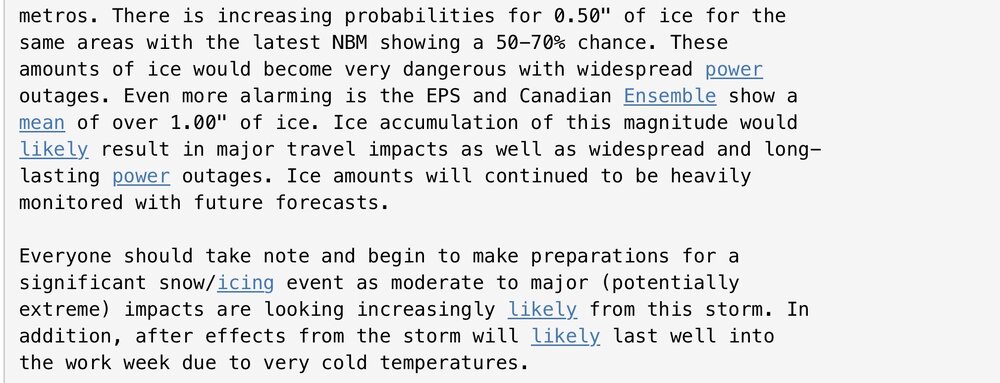
-
Richmond Metro/Hampton Roads Area Discussion
mikeeng92 replied to RIC Airport's topic in Mid Atlantic
Man 12/18 was so nice. UKMET gives us 2.4” of QPF. Incredible amounts of frozen whatever. -
Richmond Metro/Hampton Roads Area Discussion
mikeeng92 replied to RIC Airport's topic in Mid Atlantic
Not out of the woods yet. Sunday during the day looks colder but Sunday night could be a period of freezing rain or drizzle. -
Richmond Metro/Hampton Roads Area Discussion
mikeeng92 replied to RIC Airport's topic in Mid Atlantic
Was anyone around for the February 1994 ice storm? Saw that storm mentioned as an analog -
Richmond Metro/Hampton Roads Area Discussion
mikeeng92 replied to RIC Airport's topic in Mid Atlantic
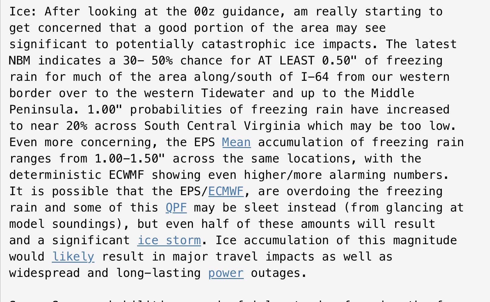
Wakefield on the ice threat: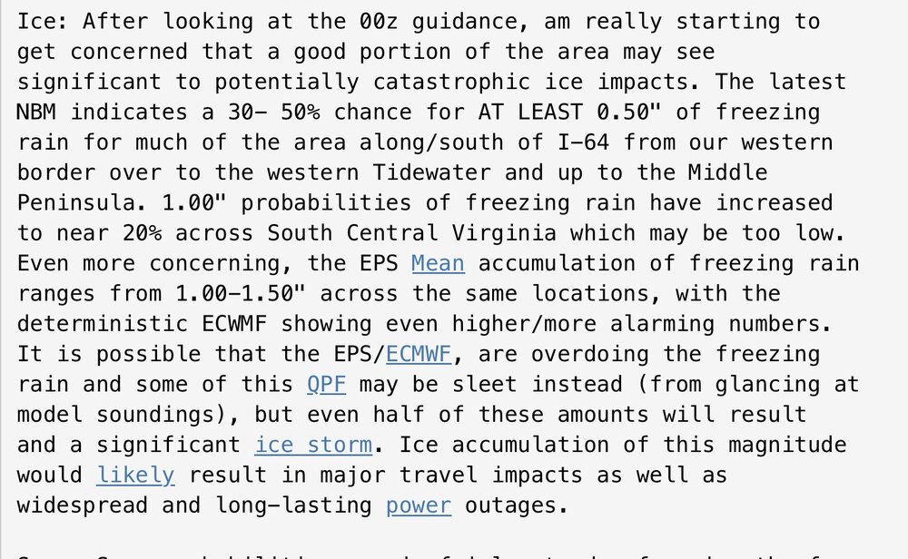
-
Richmond Metro/Hampton Roads Area Discussion
mikeeng92 replied to RIC Airport's topic in Mid Atlantic
Yea they're legit. Nice to see them more in line with the GFS. -
Richmond Metro/Hampton Roads Area Discussion
mikeeng92 replied to RIC Airport's topic in Mid Atlantic
He does. I don’t subscribe to his Patreon to see the full explanation. -
Richmond Metro/Hampton Roads Area Discussion
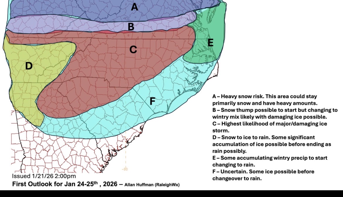
mikeeng92 replied to RIC Airport's topic in Mid Atlantic
From Allan Huffman
-
Richmond Metro/Hampton Roads Area Discussion
mikeeng92 replied to RIC Airport's topic in Mid Atlantic
Even if you cut the zr QPF in half for sleet, it’s bad . -
Richmond Metro/Hampton Roads Area Discussion
mikeeng92 replied to RIC Airport's topic in Mid Atlantic
Euro is very icy -
Richmond Metro/Hampton Roads Area Discussion
mikeeng92 replied to RIC Airport's topic in Mid Atlantic
-
Richmond Metro/Hampton Roads Area Discussion
mikeeng92 replied to RIC Airport's topic in Mid Atlantic
I was in NY for the 2007 Valentines Day storm and we got 8" of snow then 4" of sleet and it was a high impact event. Turned into a glacier, very difficult to plow. -
Richmond Metro/Hampton Roads Area Discussion
mikeeng92 replied to RIC Airport's topic in Mid Atlantic
-
Richmond Metro/Hampton Roads Area Discussion
mikeeng92 replied to RIC Airport's topic in Mid Atlantic
GFS best case scenario. CMC too amped, toss. Euro AI was still good for us I thought. -
Richmond Metro/Hampton Roads Area Discussion
mikeeng92 replied to RIC Airport's topic in Mid Atlantic
Huge to have this model still look good.