mikeeng92
-
Posts
286 -
Joined
-
Last visited
Content Type
Profiles
Blogs
Forums
American Weather
Media Demo
Store
Gallery
Everything posted by mikeeng92
-
Richmond Metro/Hampton Roads Area Discussion
mikeeng92 replied to RIC Airport's topic in Mid Atlantic
High: 76 Snow: 2”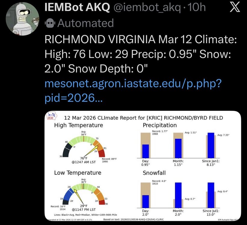
-
Richmond Metro/Hampton Roads Area Discussion
mikeeng92 replied to RIC Airport's topic in Mid Atlantic
89 record high -
Richmond Metro/Hampton Roads Area Discussion
mikeeng92 replied to RIC Airport's topic in Mid Atlantic
-
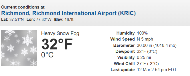
Mix of rain snow sleet and thunder
-
Richmond Metro/Hampton Roads Area Discussion
mikeeng92 replied to RIC Airport's topic in Mid Atlantic
Mix of snow rain sleet and thunder -
Richmond Metro/Hampton Roads Area Discussion
mikeeng92 replied to RIC Airport's topic in Mid Atlantic
Its trying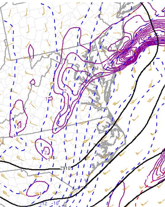
-
Richmond Metro/Hampton Roads Area Discussion
mikeeng92 replied to RIC Airport's topic in Mid Atlantic

-
Richmond Metro/Hampton Roads Area Discussion
mikeeng92 replied to RIC Airport's topic in Mid Atlantic
What I mean by maximize our chances is the models over the past couple days that gave Central VA the most snow had a fully phased storm with a tucked in low off the delmarva. That seems like its happening, we'll see if we can actually cash in. Probably not but someone in the RVA area might get 4" on the grass. My guess is Midlothian-West end Henrico- Western Hanover. -
Richmond Metro/Hampton Roads Area Discussion
mikeeng92 replied to RIC Airport's topic in Mid Atlantic
Rain and snow now. Bands redeveloping over central VA. Will be a fun afternoon evening. Storm is still turning negative now and to me looks like we will maximize our chances. -
Richmond Metro/Hampton Roads Area Discussion
mikeeng92 replied to RIC Airport's topic in Mid Atlantic
Low looks amped and tucked in so far which is what we needed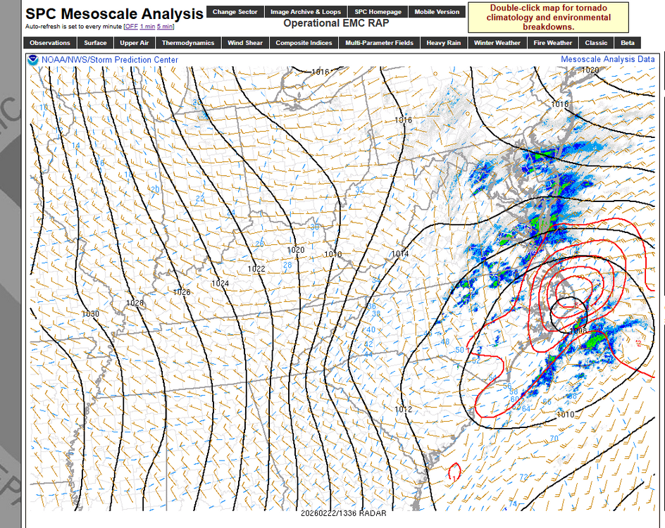
-
Richmond Metro/Hampton Roads Area Discussion
mikeeng92 replied to RIC Airport's topic in Mid Atlantic
-
Richmond Metro/Hampton Roads Area Discussion
mikeeng92 replied to RIC Airport's topic in Mid Atlantic
Awesome disco from Wakefield. Leaves the door open for the positive bust: Given how much models have trended over the past 24 hours and lingering uncertainty with respect to how much snow will accumulate farther inland, have opted to hold off on Winter Weather Advisories for this forecast cycle. The EPS probs for >3" of snow has increased to 50% all the way to Richmond with lower (but nonzero) probs extending across most of the FA. Nearly all model guidance continues to show strong banding and heavy rates of 1- 2"+/hour developing Sun evening inland as the surface low rapidly deepens and the upper level system moves overhead. As such, there likely will be a quick transition from rain to heavy wet snow for most of the area late Sun afternoon into Sun evening as the band slowly pivots E. High snowfall rates can overcome warm and wet surface conditions and lead to rapid accumulation amidst otherwise marginal surface temps. Additionally, if rates are high enough, cooler air aloft will be pulled down to the surface, likely dropping temps to around freezing (as opposed to 33-34F). As such, we have essentially two possible solutions. The first is that rates are lighter and most areas struggle to accumulate more than 1". The other possible solution is that rates overperform and we quickly accumulate at least a few inches of snow with high-end Winter Weather Advisory to low- end Winter Storm Warning criteria snowfall. Either of these is possible (or something in the middle). Therefore, will wait for the 00z model guidance to see which of the two scenarios is more likely. In any case, at least Winter Weather Advisories are likely going to be needed for a large portion of the area. -
Richmond Metro/Hampton Roads Area Discussion
mikeeng92 replied to RIC Airport's topic in Mid Atlantic
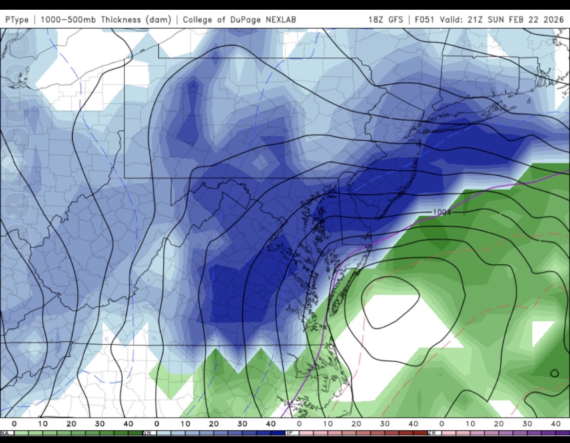
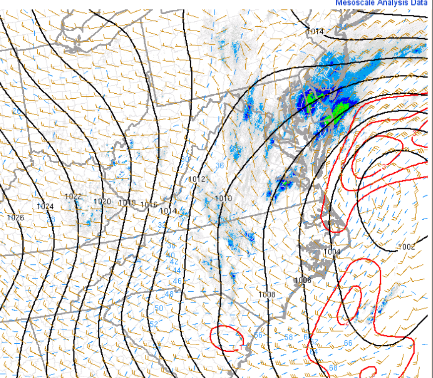
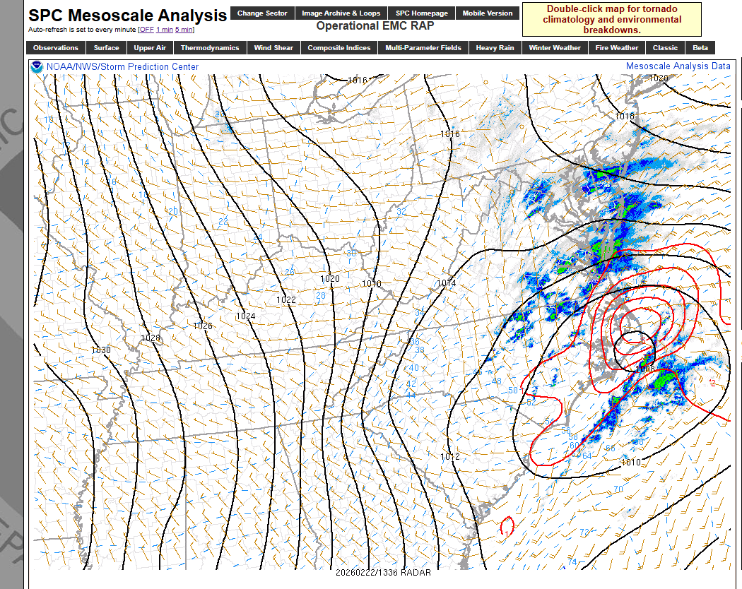
@Inudaw More amped storm helps our chances for once? Tilts the bands into RVA? -
Richmond Metro/Hampton Roads Area Discussion
mikeeng92 replied to RIC Airport's topic in Mid Atlantic
Banding into RVA
-
Richmond Metro/Hampton Roads Area Discussion
mikeeng92 replied to RIC Airport's topic in Mid Atlantic
Long range HRRR but this would be LEGIT.thumb.webp.797f159694d399677d284a5fe16b1824.webp)
-
Richmond Metro/Hampton Roads Area Discussion
mikeeng92 replied to RIC Airport's topic in Mid Atlantic
-
Richmond Metro/Hampton Roads Area Discussion
mikeeng92 replied to RIC Airport's topic in Mid Atlantic
GFS is beautiful -
Richmond Metro/Hampton Roads Area Discussion
mikeeng92 replied to RIC Airport's topic in Mid Atlantic
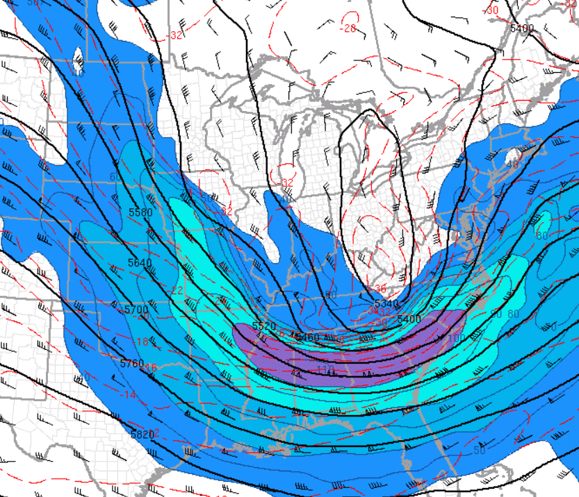
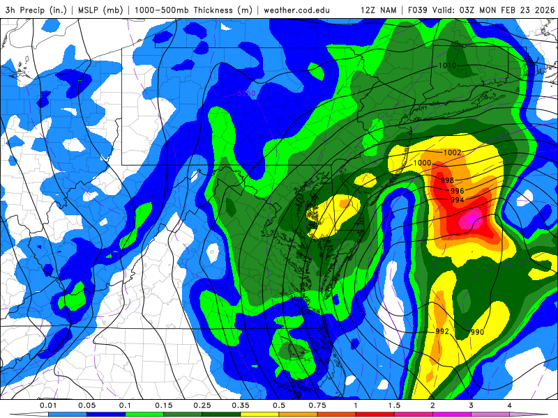
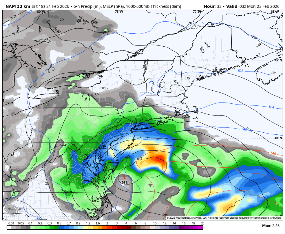
Im going with the positive bust. This isnt a typical Miller B waiting for the storm to bomb. Ton of energy dropping in with the ridge out west and the low has already formed in Georgia before moving up the coast. The NAM nailed the January storm , if it can verify like the pics below itll be like day 2 of 2016 without the cold air. Snow will accumulate when your in the heavier bands. Either way it will look epic falling.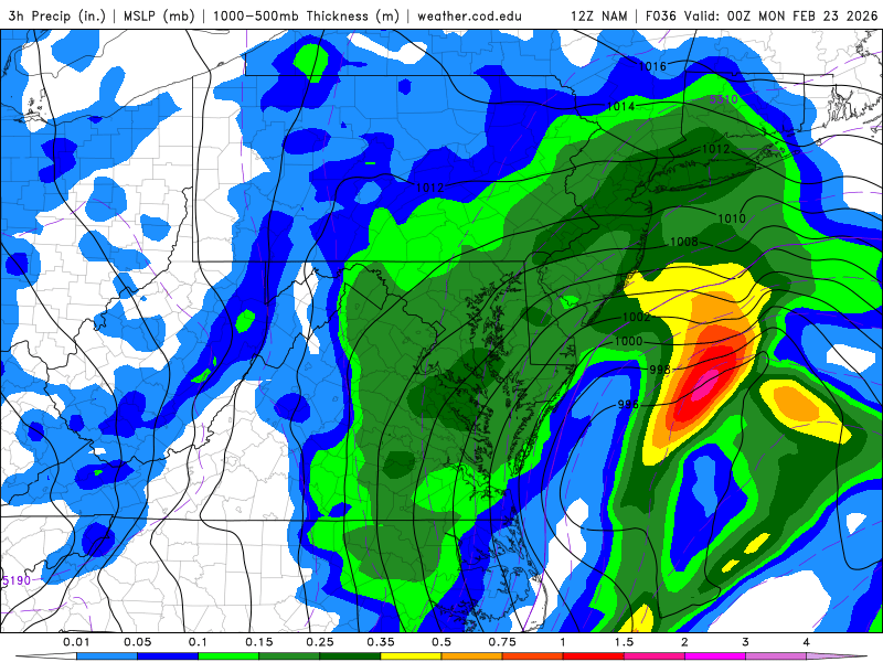
-
Richmond Metro/Hampton Roads Area Discussion
mikeeng92 replied to RIC Airport's topic in Mid Atlantic
If something like this verifies , with the upper low dynamics I think we will pile up snow quick regardless of daytime (except for roads). Depends where the bands set up. It won’t be any crazy amounts but should be a fun storm.
-
Richmond Metro/Hampton Roads Area Discussion
mikeeng92 replied to RIC Airport's topic in Mid Atlantic
NAMed! -
Richmond Metro/Hampton Roads Area Discussion
mikeeng92 replied to RIC Airport's topic in Mid Atlantic
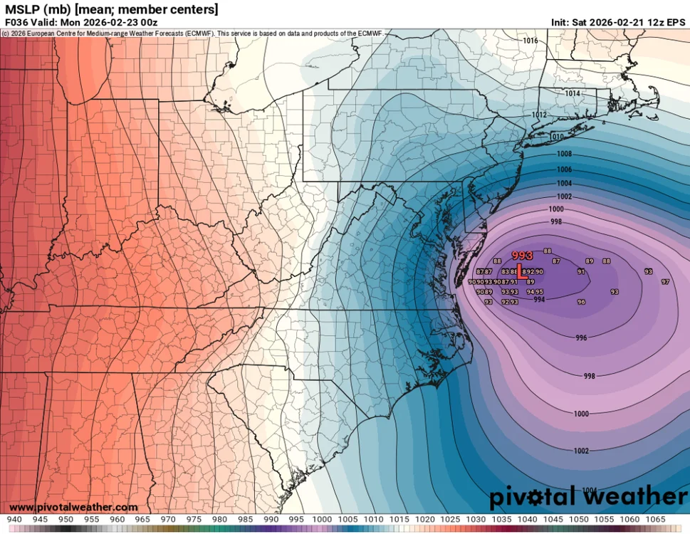
We need the storm tucked in just offshore of Delmarva to maximize potential with a deform band, like in 2016. GEFS has this. -
Richmond Metro/Hampton Roads Area Discussion
mikeeng92 replied to RIC Airport's topic in Mid Atlantic
If it’s snowing it’s cause of heavy precipitation and it will accumulate. Except for roads -
Richmond Metro/Hampton Roads Area Discussion
mikeeng92 replied to RIC Airport's topic in Mid Atlantic
Out of all the way RVA misses out on snow , this potential way is the most painful to me, being just too far west. -
Richmond Metro/Hampton Roads Area Discussion
mikeeng92 replied to RIC Airport's topic in Mid Atlantic
Wakefield not buying the GFS at all. Only mentions EURO and CMC -
Richmond Metro/Hampton Roads Area Discussion
mikeeng92 replied to RIC Airport's topic in Mid Atlantic
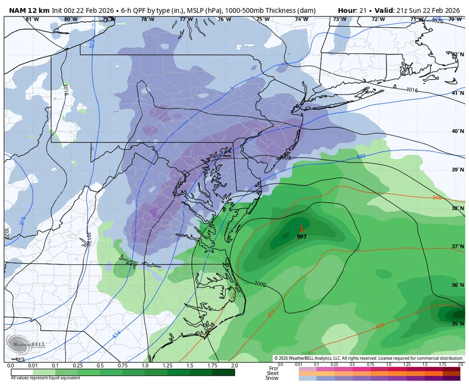
Things could still change but the way the low forms in Georgia then bombs as it moves east off OBX looks like a good move for central VA that should at least give us a period of heavy snow . Whether it sticks or not it’ll look awesome


.webp.fa9be82a99787d239bbb3a0de2548146.webp)