mikeeng92
-
Posts
286 -
Joined
-
Last visited
Content Type
Profiles
Blogs
Forums
American Weather
Media Demo
Store
Gallery
Everything posted by mikeeng92
-
Richmond Metro/Hampton Roads Area Discussion
mikeeng92 replied to RIC Airport's topic in Mid Atlantic
This is looking pretty damn good -
Richmond Metro/Hampton Roads Area Discussion
mikeeng92 replied to RIC Airport's topic in Mid Atlantic
Just hoping for one snowband to pass through at some point Sunday night. One last burst of heavy snow. -
Richmond Metro/Hampton Roads Area Discussion
mikeeng92 replied to RIC Airport's topic in Mid Atlantic
Deep winter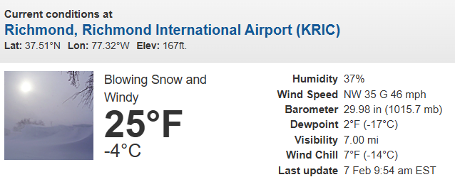
-
Richmond Metro/Hampton Roads Area Discussion
mikeeng92 replied to RIC Airport's topic in Mid Atlantic
12/5- 2.9” 12/8- 4.2” 12/14- 0.3” 1/24-1/25- 3.5” (rough guess) 2/6- 1.7” Winter grade regardless of what else happens: A+ -
Richmond Metro/Hampton Roads Area Discussion
mikeeng92 replied to RIC Airport's topic in Mid Atlantic
I measured 1.7” tonight and 12.6” for the season in 23229 -
Richmond Metro/Hampton Roads Area Discussion
mikeeng92 replied to RIC Airport's topic in Mid Atlantic
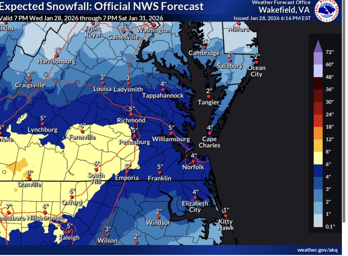
Western Hanover-Eastern Hanover-Western Chesterfield-Eastern Chesterfield (Including Col. Heights)-Western Henrico (Including the City of Richmond)-Eastern Henrico-Western King William- Eastern King William-Western King and Queen-Eastern King and Queen-Western Essex-Eastern Essex- 113 PM EST Thu Jan 29 2026 ...EXTREME COLD WATCH IN EFFECT FROM LATE SATURDAY NIGHT THROUGH SUNDAY MORNING... * WHAT...Dangerously cold wind chills as low as 5 to 10 below possible. * WHERE...Portions of central, east central, eastern, north central, south central, and southeast Virginia. * WHEN...From late Saturday night through Sunday morning. * IMPACTS...Frostbite and hypothermia will occur if unprotected skin is exposed to these temperatures. An extended period of freezing temperatures could cause ruptured water pipes. -
Richmond Metro/Hampton Roads Area Discussion
mikeeng92 replied to RIC Airport's topic in Mid Atlantic
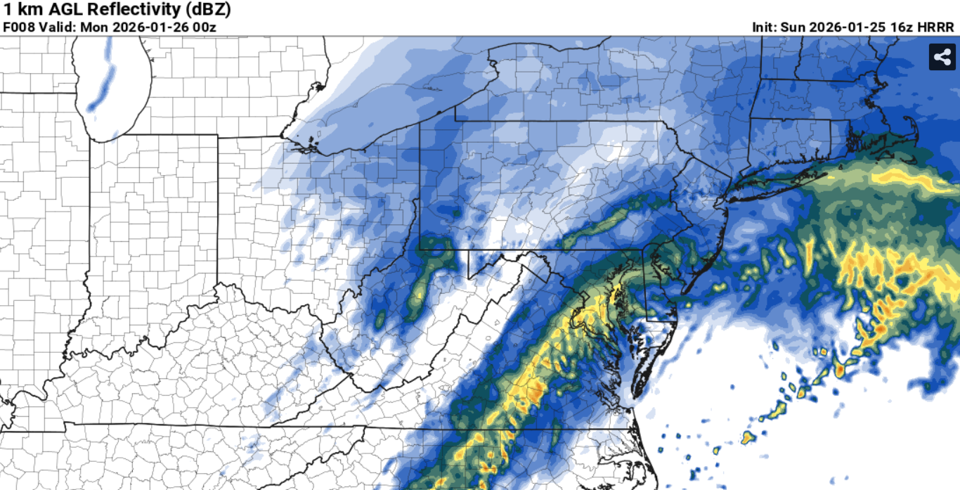
979 mb low off OBX and little precip -
Richmond Metro/Hampton Roads Area Discussion
mikeeng92 replied to RIC Airport's topic in Mid Atlantic
Yea, one band could set up and move through dropping 2-4" -
Richmond Metro/Hampton Roads Area Discussion
mikeeng92 replied to RIC Airport's topic in Mid Atlantic

-
Richmond Metro/Hampton Roads Area Discussion
mikeeng92 replied to RIC Airport's topic in Mid Atlantic
Wow huge! -
Richmond Metro/Hampton Roads Area Discussion
mikeeng92 replied to RIC Airport's topic in Mid Atlantic
Absolute trash model -
Richmond Metro/Hampton Roads Area Discussion
mikeeng92 replied to RIC Airport's topic in Mid Atlantic
Not bad, I want 4" -
Richmond Metro/Hampton Roads Area Discussion
mikeeng92 replied to RIC Airport's topic in Mid Atlantic
Got to see how the rest of today’s 12z runs go -
Richmond Metro/Hampton Roads Area Discussion
mikeeng92 replied to RIC Airport's topic in Mid Atlantic
I would take any snow on snow. When was the last time we had that? it would be nice to get any amount over 2” from this storm. -
Richmond Metro/Hampton Roads Area Discussion
mikeeng92 replied to RIC Airport's topic in Mid Atlantic
Unfortunately just cant trust the GFS right now, its been terrible. -
Richmond Metro/Hampton Roads Area Discussion
mikeeng92 replied to RIC Airport's topic in Mid Atlantic
LOL 30" with gusts to 50 -
Richmond Metro/Hampton Roads Area Discussion
mikeeng92 replied to RIC Airport's topic in Mid Atlantic
CMC absolute Nuke -
Richmond Metro/Hampton Roads Area Discussion
mikeeng92 replied to RIC Airport's topic in Mid Atlantic
Crazy how fast that ice built up since the start of that batch -
Richmond Metro/Hampton Roads Area Discussion
mikeeng92 replied to RIC Airport's topic in Mid Atlantic
Trudging through the sleet on a long walk -
Richmond Metro/Hampton Roads Area Discussion
mikeeng92 replied to RIC Airport's topic in Mid Atlantic
Just heard from a plow operator in the east end of Henrico. Freezing rain has begun with instant accretion. -
Richmond Metro/Hampton Roads Area Discussion
mikeeng92 replied to RIC Airport's topic in Mid Atlantic
We have the ice thunderstorm freezing squall line thing to look forward to later
-
Richmond Metro/Hampton Roads Area Discussion
mikeeng92 replied to RIC Airport's topic in Mid Atlantic
MPING report just came in for ZR in New Kent. Def marching west -
Richmond Metro/Hampton Roads Area Discussion
mikeeng92 replied to RIC Airport's topic in Mid Atlantic
It’s pretty bad. The snow stuck immediately and now it’s all compressed down. -
Richmond Metro/Hampton Roads Area Discussion
mikeeng92 replied to RIC Airport's topic in Mid Atlantic
Just drove from east end to west end and roads are in bad shape -
Richmond Metro/Hampton Roads Area Discussion
mikeeng92 replied to RIC Airport's topic in Mid Atlantic
18Z NAM is a best case scenario for RVA with ice. Cant see FRAM but QPF is .3 west end to .7 east end. Has less QPF tomorrow afternoon when other models have more falling as ZR. Edit: although freezing drizzle could add up fast