

LakeEffectOH
-
Posts
299 -
Joined
-
Last visited
Content Type
Profiles
Blogs
Forums
American Weather
Media Demo
Store
Gallery
Posts posted by LakeEffectOH
-
-
Satellite today shows that a lot of ice melted between Toledo and the Erie Islands.
Incredible that we've yet to have a legitimate storm to track this season. Winter 2011/2012 seems like a winter wonderland in comparison to this year.
If CLE had the 10th snowiest February, March, AND April they'd still finish over 10 inches below normal on the season. While I wasn't expecting normal snowfall this winter, at this point way below normal is pretty much a lock.
...Pretty ugly, ECM ensembles (0z) showing another major storm for mid atl to sne towards the end. Another storm to our west...For the most part, the NEOH snowstorm shield holds strong as it has since Feb. 2013.
-
Athens is running a bit ahead of CLE snowfall wise for the season with about 12", almost normal for the whole season. You guys will get lucky eventually
I hope so. Except for GHD II last year, we've been missed by not only conventional snowstorms but clippers too. We've been on a pretty unlucky streak since 2012-2013. Not counting 2011-12 because the entire lower 48 got shafted.
-
You have a ton of snow in Chesterland. As soon I hit Farmount heading north on 306 there was a sharp increase in snow depth. Great event for your location. What a crazy gradient.
NEOH, thanks for the report! It will be interesting when I get home. Here in Solon, I'd say there's 3-4".
-
Welcome to the northern ohio crew. LES is fickle around here so we can all share in the misery together at some point. It's has been a rough winter if you need a NW wind direction. Luckily for you lake huron is still wide open. Despite record breaking warmth in December a good chunk of the fetch we need is frozen over. Ouch!
I'm wondering when we will get a good synoptic storm. So far this year, CLE has had 7.8"...ugh! I consider myself very fortunate for getting hit hard, but I feel bad for the rest of the region as snow totals are for crap. February into March looks promising as the longer range models (except for the torchy CFS...surprise! surprise!) are pumping a PNA ridge and hinting of a return to at least a -AO after the modeled early Feb. thaw.
-
Nice! I'll be in Chesterland later today. Us folks just 5 miles or so south don't even have half of that.
Let me know how it is there. Left Chesterland at 7:30am today and the radar was showing heavy snow sitting over there all morning. I'm anxious to know how much is actually up there.
-
I picked up over 20" in the last couple of days!!
-
Hopefully the Sunday/Monday time frame delivers for LES. Models are pretty consistent in showing winds in the 280-290 range for a fairly long period. Always subject to change but nice to see. This is basically the ideal flow for a firehose band. Dry air is a concern but this flow also brings moisture from Lake Michigan. For IMBYpurposes, I'd like to see a sustained 290 flow.
When the winds go over 290, the LES event becomes kind of a meh event. 290+ NW events are better for the I-80 corridor.
-
I've also wondered if there's ever been a north south primary band from Lake Huron that continued across Erie into Cuyahoga for any appreciable amount of time. I'd imagine these are rare but if the do happen could produce those 1-2' event totals.
From 12/2/2005 - 12/4/2005, I remember a LES event that involved a persistent band that actually originated over Superior then made a right turn, crossed the length of Huron...across Erie into NEOH. Chardon picked up 27" from that one, I got around 2 feet.
As far as Cuyahoga County went...I worked in Solon then and Solon had somewhere between 15 and 20 inches. 15"+ snowfall totals over the eastern quarter of Cuyahoga were common. Hopkins had around 8.5".
-
After a nice chunk of my life, here's my best guess verification map for the past event, clipper and LES included:
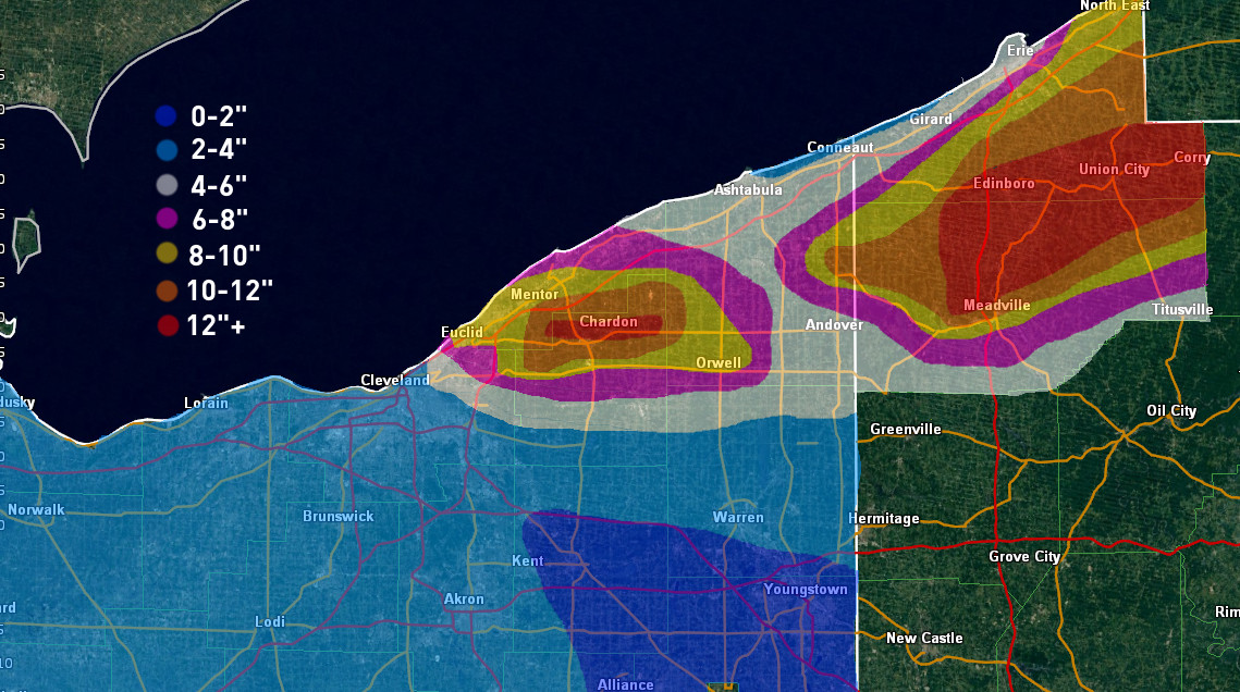
A few notes on the map itself:
-There were few spotter reports in eastern Ashtabula County and western inland Erie County that were "reliable"...I say this because there were a few spotters that called in for parts of the event but didn't for others when I knew they got snow. The only good reports in that area were MAIDEsNow's 14" report from NW Edinboro and a spotter that had a total of 13" just NW of Edinboro as well, along with 11" from a spotter near Pierpont. Radar overshoots LES badly in Ashtabula/Erie/Crawford so unfortunately I had to do a lot of guessing there based on terrain, surrounding reports and what radar happened to picked up there.
-The only good reports in eastern Cuyahoga County and western Geauga County were a total of 8.8" in Euclid from a trained spotter...11" 2.5 miles north of 322 from LakeEffect in Chesterland, and 4" in Newbury/South Russell from dta and NEOH. Luckily radar doesn't overshot LES there so I feel much better about that area, but the lack of reports and sharp cutoff mean I may be a little off. The 8" edge looks jagged in NE Cuyahoga, however, that is supported by radar, as there was a good period where the band absolutely ripped on Euclid but areas immediately southwest weren't getting good snow, and a period of time earlier on in the evening when the band was farther south where heavier returns were consistently just east of 271. It's probably not perfect and a few of you live/work in/drive around in that area, so if that looks off please let me know and I can tweak.
As for the forecast, was a little low on max amounts. The band placement in NE Ohio was pretty good compared to forecast, however what I needed to do was extend heavier amounts much closer to lakeshore. It seems like these firehose bands driven by strong convergence are the one type of event that do well all the way down to the shore, so it's something to keep in mind going forward. That was the biggest thing on my map that I ended up not liking. I did pretty good in Erie County PA but worse in Crawford PA. I'm trying to get better in that area, but I haven't been able to watch events there on radar for years and years because radar overshoots LES there, so it's still a process.
Next event could be interesting, so on to that one.
Good job OH Weather...I really like how you explain, in detail, how you explain your LES forecasts. Looking forward to your insight for next week's event(s)!
-
Congrats on the snow. Are you north of 322? Looks like a decent set-up early next week.
Thanks!!
Yep, I'm about 2.5 miles of 322.
-
Nice!
Hope to be getting more this weekend and early next week. 12z GEM is showing a nice setup for a W-E band of LES after this weekend's cutter. 12z GFS is depicting this as well.
-
Hey all! Between the clipper (~2") and the LES (~9") I picked up around 11" since late Monday night. There was around 8" on the ground when I left for work at 8:30am.

-
Nice fat flakes here. Can't wait until the wind picks up!
-
They actually have 5"+ as far west as KCLE and 8"+ for central Geauga eastward. I think their amounts are often ball park or even too high, but they have been very conservative with issuing winter headlines, especially this winter. I'm sure they have their reasons, but I really think this needs an advisory or even warning for the reasons I laid out above. Their snowfall amounts would at least suggest an advisory if not warning based on the blowing snow. I'm sure they'll issue something later tonight or tomorrow.
Thanks for the update! Yeah, I bet they will have to force themselves to issue an advisory. They had no mention of snow/blowing snow in their latest Haz Wx Outlook. You would they would have mentioned something.
-
I'm fairly surprised there's no advisory from Cleveland. I think an area-wide 2-4" of snow is a good bet with another 1-2" at least from lake effect in the higher terrain. It's not the most snow, but there's a very good signal for a couple hours of very squally weather with the arctic front with blinding snow showers and 40MPH wind gusts, which by itself is almost enough for an advisory. Behind the front, with a very deep layer of steep lapse rates and good ambient moisture, any moisture from upstream lakes or from Lake Erie that makes it onshore and hits the terrain could cause continued squalls through a good portion of the afternoon with gusty winds.
Flake size will be very small by later tomorrow due to the cold, but with the wind the fine flakes could cause very poor visibilities to continue in the higher terrain clear into tomorrow evening. I could honestly see areas from Lorain and Medina Counties points east (especially in the higher terrain) seeing hours (from late morning straight through the afternoon and potentially into the evening in a few spots) of visibilities below half a mile and gusty winds. Even if the higher terrain only gets 4-6" or so of snow, the prolonged potential for very poor conditions would honestly prompt me to issue a warning from Lorain and Medina east through the Snowbelt if I was sitting in that chair today and had that ability. But, I'm not, so I could be off base. At the very least an advisory seems prudent.
As you guys know, the Cleveland NWS seems to be averse (being nice here) to issuing winter weather warnings. I remember when the March 2008 snowstorm was approaching/occurring, all of Ohio was under a blizzard warning except for the Cleveland CWA which stuck to winter storm warnings.
...Funny how northern IN and western NY are under a winter weather advisory, winter storm warning respectively. For Cleveland, only a wind chill warning. Surprised they issued a warning as it would be in keeping with their style to issue just a wind chill advisory.
I'm really puzzled as to why CLE is always lowballing winter events (exception being the 2012 Boxing Day storm when CLE issued a blizzard warning...I was shocked at that.).
-
Looks like CLE waved the white towel on next weeks potential --
.LONG TERM /MONDAY THROUGH THURSDAY/... THING WILL BE WARMING AT THE START OF THE PERIOD WITH HIGHS ON
MONDAY GETTING WITHIN 20 DEGREES OF NORMAL MOST AREAS. FORTUNATELY IT LOOKS LIKE WINDS WILL BE FAIRLY LIGHT WITH HIGH PRESSURE RIGHT OVERHEAD. HAVE MADE SOME SIGNIFICANT CHANGES TO THE MONDAY NIGHT
INTO WEDNESDAY PERIOD. BOTH THE 12Z GFS AND ECMWF HAVE THE LOCAL AREA UNDER AN AREA OF SUBSIDENCE BETWEEN SYSTEMS TO THE NORTH AND SOUTH MONDAY NIGHT AND TUESDAY. SOME LIGHT SNOW COULD SNEAK INTO
THE SOUTHERN END OF THE AREA DURING THE DAY BUT HAVE REMOVED ALL MENTION FROM THE NORTH. SLIGHTLY BETTER CHANCES FOR SNOW EXIST TUESDAY NIGHT AND WEDNESDAY...ESPECIALLY IN THE EAST WHERE THE EFFECTS AND MOISTURE FROM THE LATEST STORM MOVING UP THE EAST COAST WILL BE MOST FELT. THINGS WILL DRY OUT BEHIND THIS SYSTEM AND DO NOT THINK THERE WILL BE MUCH LAKE EFFECT WEDNESDAY NIGHT AND THURSDAY. TUESDAY WILL BE THE WARMEST DAY OF THE PERIOD WITH HIGHS PERHAPS MAKING THE MID 20S BUT THE REMAINDER OF THE PERIOD WILL BE VERY COLD.
Right now it may look like we will be whiffed to the south, but this year, modeled storms have had a tendency to creep NW from where they were originally modeled to go. Lack of blocking may help us out. Depends on how this weekend's New England storm affects subsequent ridging off the East Coast. Don't want Boston stealing our snow. Lol!

-
Snow has picked up in Chagrin. Looks like a dust storm with the snow being so fine. Inversion must be really low as well... sun keeps peaking through. Old/dirty snow has been covered though.
Been snowing here in Solon...visibilities are reduced due to snow and blowing snow. Wind trajectory is a little more west of north bringing the snow here. Air is very dry though making accumulations less than they seem when looking outside into reduced visibilities.
-
...Got about .3" of snow last night here in Chesterland. WOW!!!
OHweather, what do you think about Saturday's event?
-
I'd have to imagine you'll get another 1-3" as the "deform" swings through with some lake enhancment. Hundreds of schools already closed for tomorrow.
Cool! I think one thing that has helped us tonite is that there is no rapidly bombing Coastal, yet, to suck all of the energy away from the primary resulting in the widespread greens on radar rapidly disintegrating into feeble scattered blue streaks.
-
31/31 IMBY just a little south of you. Hopefully we can hold on to all snow. I noticed the heavier returns to the west/southwest. Each time they move over flake size increases along with intensity. Keep waiting for the mix to move in but not so. Winds are out of the east... have to wonder if that is keeping the cold air locked in place.
Just measure over 19" on my deck. The surprise LES the other day made a nice base.
Big heaps of wet snow on my deck...have to measure it. I wonder how much snow we will be getting from the clippers this week? 12z Euro forecasted snow depths in the CLE are approaching and even exceeding 30" by this time next week. Maps are most likely overdone but they really stoke the
 in me!
 -
That's true. We shall see if they clean things up in the PNS later or send out storm total numbers tomorrow. Would be nice!
8.5" is not a bad storm! This has got to be rivaling your biggest storm since early 2011 I'd think? I'd have to imagine double digits will be easy for Cleveland proper at this point.
I'm wondering when the winds back around to the North & NE, as the arctic air moves in whether or not we will have a period of lake enhanced snows that will drop an additional few inches along with a lot of blowing. I have a feeling the morning commute will be pretty messy.
-
No doubt... radar looks great. Temp just jumped to 31. Not sure how much more we will climb. Looks like a mostly snow event... perhaps a brief mix but not much.
As Trent mentioned, this is some of the heaviest snow we've had in quite some time. It just seems so much more substantial than fluff.
Huge flakes and heavy snow right now. Good tiimes...
Yes it is...Good times! Earlier on the radar, there were yellows & a few oranges to our west which indicated sleet mixing in. I wondered if that would be moving NE into the CLE area, but now it is a bright green to our west indicative of more snow. to come. Also the NWS upped tonight's accumulation from 3-5 to 3-7.
-
I'm riding that mixing line buy it has managed to stay all snow and big fluffy flakes falling fast
Sounds good! This is one of the few times we have not had to deal with aggressive warm air advection from the south and southwest. Doesn't look like it will be much of a problem either.
-
...Just peeked at the CLE radar and I can honestly say that is one of the best looking radars I've ever seen during a storm here.

Northern Ohio Obs/Discussion Part 2
in Lakes/Ohio Valley
Posted
I think the 2nd half of Feb well into March will be the best part of this winter. Unfortunately, it is also the end part of this winter. Hopefully our luck will change.