

LakeEffectOH
-
Posts
299 -
Joined
-
Last visited
Content Type
Profiles
Blogs
Forums
American Weather
Media Demo
Store
Gallery
Posts posted by LakeEffectOH
-
-
7 minutes ago, OrrvilleWX said:
It’s been snowing consistently here in Orrville. No breaks since it’s started.
How much do you think you've gotten?
-
1 minute ago, Floydbuster said:
It's snowing decent but small flakes in Stow. My girlfriend in North Royalton says it's a whiteout.
If it picks up the pace and continues until tomorrow morning, we should pick up some good accumulation. It does seem to be lacking that "storm" feeling though.
I know what you mean. In Chesterland is alternates between light/moderate snow with heavier bursts. Had about 3 inches so far.
-
4 minutes ago, NEOH said:
It is strange. No idea what would cause that. I could see something like that from down sloping but with a North/Northeast wind its all upslope in our area.
Sure, maybe bad data. Would be crazy if it verified!

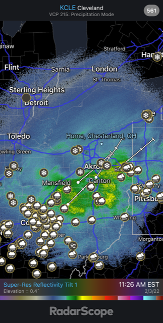
Meanwhile, the radar looks good. Definite SW-NE movement up 71.
-
That hole is weird. Wonder what the models are seeing or did they ingest something weird from a common dataset??
-
1 minute ago, NEOH said:
Steady moderate snow with occasional heavier bursts. Heavier snow should be moving in from the SW soon and last quite awhile. Eyeballing 3" or so already. The 12z models show a lot of snow to come.
Good news! Radars look good...
-
Radar shows heavier precip moving up I-71.
-
Snow is moderate here. So far, looks like there are 2-3 inches of new snow on my deck.
-
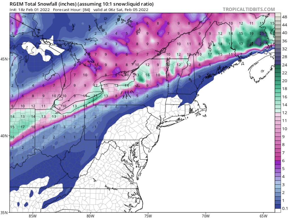
18z RGEM has come appreciably south.
-
 1
1
-
-
Does anybody know why Lake and Cuyahoga county are under a winter storm warning while a winter storm watch is still in effect for Geauga and Ashtabula county. For sure, CLE is not thinking of the possibility of putting these counties under and advisory...
-
5 minutes ago, WHEATCENT said:
GDPS gives the lake 0.5 miles from me a foot.....lmao
RGEM looks like it trended south a bit. Previous runs showed the snow hardly touching the lakeshore.
-
33 minutes ago, Floydbuster said:
Hmmm. Not bad but hoping for a few inches more. That map gives me about 6-8 inches.
I listened to BAMWX's storm discussion and the Met said that after watching these kind of storms for several years, he thinks there may be some southward drift in the accums, but a pretty hard hit of snow for NEOH.
-
3 hours ago, NEOH said:
Despite all of the shuffling on the models I think we are in a good spot for this one. Hopefully there will be more consensus with tonight's runs.
I think you're right!
")
-
21 minutes ago, amt5626 said:
Back at my apartment in Toledo for this one. Should be a great event here. Depending on how Thursday's snow shapes up, could be really something special. 12" looks to be a lock for now.
Toledo deserves a good one! So far, this has been a lousy winter for you guys in terms of snowfall.
-
1 hour ago, NEOH said:
Despite all of the shuffling on the models I think we are in a good spot for this one. Hopefully there will be more consensus with tonight's runs.
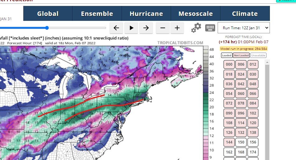
12z Euro ran just a bit south. No system split like the GFS was showing.
-
GFS looks like it's trying to break the storm in two. 6z showed essentially the same thing.
All other models thus far are north and still, ostensibly, are are a single storm.
...Waiting with baited breath for the 12z Euro.
-
Looks like Weatherbell is under an ECWA (East Coast Weenie Attack).
Site is running very slow...
-
Looks like Weatherbell is under an ECWA (East Coast Weenie Attack).
Site is running very slow...
-
Looks like Weatherbell is under an ECWA (East Coast Weenie Attack).
Site is running very slow...
-
4 hours ago, NEOH said:
That's normally a great spot for LES. The snow was definitely localized... it snowed quite heavily under the heavier cells.
We have a great snow pack out there for a change. Hopefully it can survive next weeks warm up and rain. Maybe we will see a few changes in the models over the coming days.
Yep, we can get hit pretty hard here. Hopefully the warmup next week doesn't do a number on the snowpack. Next week's storm is still iffy. The overnight models trended a little colder, but colder trend was erased by today's midday models. Still have to see what the ECMWF has to say.
These Chicago-Detroit storms have to be watched as we could get a nasty mix of snow and ice or if the storm strengthens, it can blast rain & 50°+ this way. There is nothing that melts a snowpack (even one that is like concrete) faster than several hours of 50° and rain.
Keep fingers and toes crossed. Lol!
-
Yep, for the most part, this event was a lakeshore runner, though NEOH did manage to get some out of it.
-
2 hours ago, WHEATCENT said:
I'm in extreme north mentor near fairport and grand river and we've gotten maybe 2 inches since Monday
That's a little surprising because yesterday, it looked as the lakeshore was where the bands were more organized.
-
1 hour ago, NEOH said:
That’s weird. Where in Chesterland do you live? Some of the heavier snow showers were localized but they must have moved through chesterland before moving south down this way. I’m in the far eastern part of south Russell near the Newbury border
I live about 3/4 miles east of 306 around 2 miles north of 322...far northeastern part of Chester twp. Looked to me like some of the snow showers moved SSE from west of my area to your area, thus missing my place. Also, the cells seemed smaller and less organized as compared to recent events. Looks like the freezing of the Lake might be doing its dirty work.
-
No snow whatsoever (except a few light flurries) here since Monday. I wonder how much the lakeshore towns such as Mentor & Painesville have gotten since Monday...Anyone have any idea?
-
Looked at the radar again...the heavier stuff looks as if it just blasted thru at 90mph, lol! Still snowing pretty good, but not as hard as a few minutes ago. Flakes have shrank some...
Northern Ohio Obs/Discussion Part 2
in Lakes/Ohio Valley
Posted
The heavier snow has gotten more consistent now as opposed to the off and on bursts like I saw earlier.