

LakeEffectOH
-
Posts
331 -
Joined
-
Last visited
Content Type
Profiles
Blogs
Forums
American Weather
Media Demo
Store
Gallery
Posts posted by LakeEffectOH
-
-
15 hours ago, purduewx80 said:
The bias corrected Euro sits and spins in the warm phases, which is similar to the CFS.
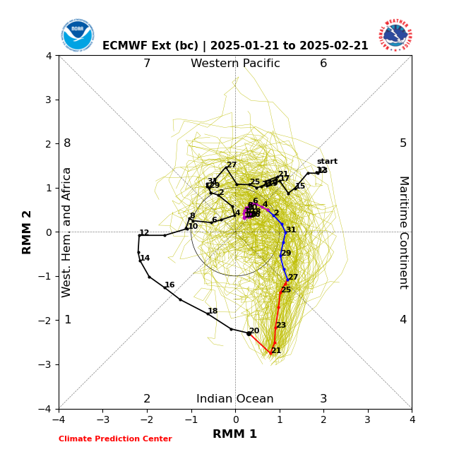
Looks as the mean gets stuck in the COD. IMHO, that means a muted effect.
-
 1
1
-
 1
1
-
-
8 hours ago, NEOH said:
That was a nice finale to the LES season. Picked up 5.5" IMBY. Good to have fresh powder on top of the old snow.
Awww, don't say that...remember April 2007?

-
1
-
-
19 hours ago, OHweather said:
Nice overperforming, fluffy lake effect event. I'm nearing 6"!
Had about 8" of fluff yesterday. We must have been caught under that same persistent N-S band coming off L. Huron.
-
12 hours ago, Snowstorms said:
Lake effect is nice but incredibly localized. A single squall line could literally be only 15-20 miles long in width meanwhile the people outside that boundary are dry and snowless.
Made it up to 19.5" here in Toronto thanks to these 1-3" clippers and lake effect. Still running below average though for the ytd.
Tell me about it...back in early December, Saybrook, OH had over 5 feet of snow via lake effect. I live about 15 miles from there and there was not even a dusting. Several days later, I finally had about 6 inches.
-
2
-
-
31 minutes ago, NEOH said:
Lots of ice on the western basin already. Probably closed for business soon. This is a cam from middle bass island looking west-- once this area is ice covered the remainder of the western basin is as well - http://64.246.98.57/CgiStart?page=Single&Language=0'
Yeah, from the looks of the water, I'd imagine that area will be frozen over in a matter of days.
-
2 hours ago, NEOH said:
Picked up another 1"+ last night/this morning. Snow growth must be poor as it is mainly snow pellets.
When I left for work this morning, there was freezing drizzle and snow pellets falling. Snowing nicely here at work in Solon.
-
Nice! NWS is forecasting off & on LES this week (2 events to be more accurate), though amounts will be light. NWS keeps going back and forth with 1-2"/event to less than one inch between point forecasts.
I just hate the term less than one inch or one half inch. Ugh!
-
Hopefully we can see more LES this coming week. As more ice forms on the lake, the chances of particularly heavy snows will decrease.
While it’s certainly been cold, it hasn’t been that cold, plus we had a mini torch between Christmas and New Year’s. Hopefully these two factors will buy us a little more time.
I have had about 11” since it started snowing on New Year’s night.
-
-
37 minutes ago, NEOH said:
Nice. Its always good to get off to a fast start. We'll see what the rest of the day/nights brings.
And tonight-tomorrow as well
-
23 minutes ago, NEOH said:
Picked up 4.4" of snow already. It was just dumping earlier. Snow starting to pick back up... and the heavy snow over the lake looks to push south directly into the area circled by OHWeather.
4-5” is about what we’ve picked up here in Chesterland so far today. Wind is picking up too!
-
1
-
-
3 hours ago, OHweather said:
Yes communicating that local variability to the public is always a challenge because people do tend to gravitate towards the highest number they see. Totals will definitely vary based on where bands setup, but I think most of the area will get a good amount of snow. There’s a decent amount of synoptic support through this evening and then a decently prolonged period of lake effect tonight and tomorrow.
We should be good, can see the band starting to push south over western Lake Erie as the wind shifts. The vort max NEOH pointed out will help force bands onshore and also will add a good amount of synoptic support.
Yes! Thanks! Snowing like crazy out now. Just had a bout of pessimism, especially after being missed by the severe LES of early December
-
4 hours ago, NEOH said:
That will be moving inland once the shortwave passes and winds shift to the WNW. Winds are still SW'erly at this point. Check out the shortwave over central MI - https://weather.cod.edu/satrad/?parms=subregional-MI-13-24-0-100-1&checked=map&colorbar=data
That should provide additional lift and increased snowfall.
Heavy snow here! I guess my inner
 reminded me of how I missed epic LES snowfall by 10 so miles, not to mention several big ticket LES vents over the last few years.
-
Well, is our LES storm going to deliver or will it be another Ashtabula/Erie special? Bands appear to be parallel to the lakeshore.

-
1 hour ago, OHweather said:
Pretty good signal for periods of decent lake effect starting Wednesday or Wednesday night and lasting through Saturday with a west-northwest flow. It won't be a prodigious lake effect event, but the setup looks solid enough.
With the extended cold coming up, a good, hopefully deep, snowpack will develop over the next couple of weeks.
-
Hopefully we’ll get more LES this next time around than we did earlier this month due to the lakeshore hugging nature of the snow bands.
-
35 minutes ago, ChiTownSnow said:
i see he is to mid january now (it was dec 25th-30th). still at the denial stage.. next step is acceptance.
Reminds me of JB.
-
Don't look now, but I saw the BAM Wx long range video today. Walt really backed off on the early - mid January cold. He said the polar vortex, in the models appears to be moving to the other side of the globe.
-
1
-
 3
3
-
-
Had about 2" in Chesterland, but when I arrived at work, in Solon, I saw at least 6" on the picnic tables!
-
Don’t have a good feeling about places south of Rt 6…growing bust potential. I think the heaviest snow will stay to the north in Lake County with 1-3 inch totals south of Rt 6. Hopefully I’m wrong.
-
44 minutes ago, OHweather said:
…Still looks good for stuff to shift farther inland by Sunday night or Monday…
What do you think the snow potential is for Northern Geauga county is for Sunday night and Monday?
-
Is anyone here on the Bluesky App?
-
2
-
-
5 hours ago, snowman19 said:
Does anyone have some idea as to what's causing this marine heatwave?
-
47 minutes ago, donsutherland1 said:
Just released C3S multi-model outlook for December 2024-February 2025:
North America:
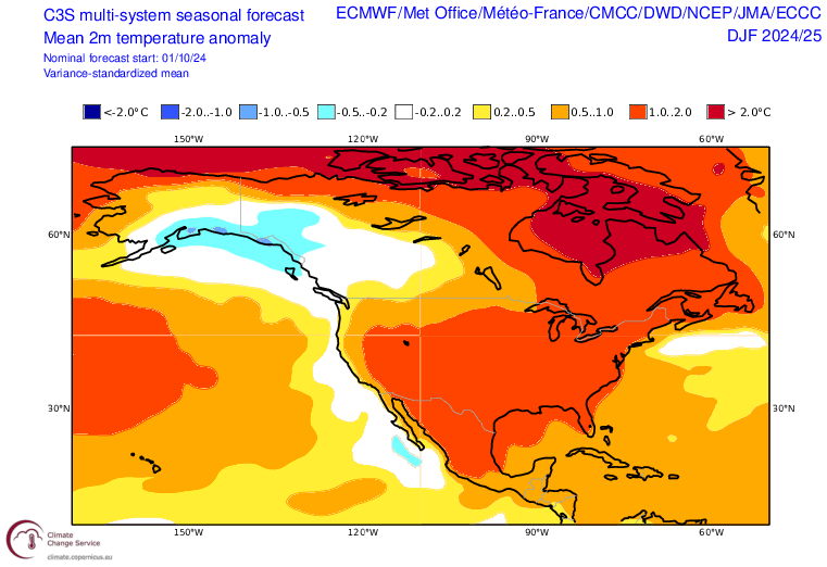
This outlook doesn't surprise me with the PDO setup we currently have. This PDO setup will probably persist into the winter months.
-
1
-


Northern Ohio Obs/Discussion Part 2
in Lakes/Ohio Valley
Posted
I got around an inch here.