LakeEffectOH
-
Posts
359 -
Joined
-
Last visited
Content Type
Profiles
Blogs
Forums
American Weather
Media Demo
Store
Gallery
Everything posted by LakeEffectOH
-
Looks like Weatherbell is under an ECWA (East Coast Weenie Attack). Site is running very slow...
-
Yep, we can get hit pretty hard here. Hopefully the warmup next week doesn't do a number on the snowpack. Next week's storm is still iffy. The overnight models trended a little colder, but colder trend was erased by today's midday models. Still have to see what the ECMWF has to say. These Chicago-Detroit storms have to be watched as we could get a nasty mix of snow and ice or if the storm strengthens, it can blast rain & 50°+ this way. There is nothing that melts a snowpack (even one that is like concrete) faster than several hours of 50° and rain. Keep fingers and toes crossed. Lol!
-
Yep, for the most part, this event was a lakeshore runner, though NEOH did manage to get some out of it.
-
That's a little surprising because yesterday, it looked as the lakeshore was where the bands were more organized.
-
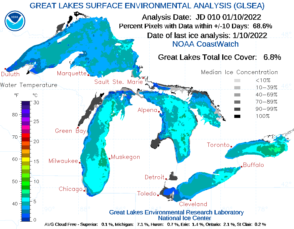
I live about 3/4 miles east of 306 around 2 miles north of 322...far northeastern part of Chester twp. Looked to me like some of the snow showers moved SSE from west of my area to your area, thus missing my place. Also, the cells seemed smaller and less organized as compared to recent events. Looks like the freezing of the Lake might be doing its dirty work.
-
No snow whatsoever (except a few light flurries) here since Monday. I wonder how much the lakeshore towns such as Mentor & Painesville have gotten since Monday...Anyone have any idea?
-
Looked at the radar again...the heavier stuff looks as if it just blasted thru at 90mph, lol! Still snowing pretty good, but not as hard as a few minutes ago. Flakes have shrank some...
-
LEH is on! Ripping out here! Nice big flakes...
-
Got the better part of an inch today in Chesterland. Checked the radar and from what I can see, the back side is now moving in with some lake enhancement perhaps. Looks as if the back side may well be the more productive part for this event.
-
He was...
-
I think this one will come down to the wire. We're so close. May not be a blockbuster but I think we will see decent accumulations...likely to be much more than what we've seen so far this winter. Another thing, during La Ninas in particular, winter storm tracks, coming this way, have, verified more NW than modeled. Such events have ended up bringing decent accumulations (3"-5")well NW (Detroit, for example) when modeling called for like a coating to an inch though I doubt this go-around will take accumulating snows that far NW. I do remember (correct me if I'm wrong) the Christmas storm last year...for 4-6 days before the storm, models ECMWF, GEM, GFS) were fairly consistent on bringing a good storm to NE OH and NC OH. A white Christmas looked like a good bet. About 3 days prior to the storm, the GFS began playing games as one run had the heavy snow back as far west as South Bend IN and east central Michigan while seemingly, the very next run, the GFS lurched the max amounts well east of here progging paltry amounts (coating to 2") to most areas except the OH-PA border which was progged to get like 3-4". Within 36 hours of Christmas day, GFS finally caved to the other models which always had NE OH in a favorable location. We shall see...
-
Soooooooo tired of hearing nothing more than the term inch or less in the wx snow accum forecasts...
-
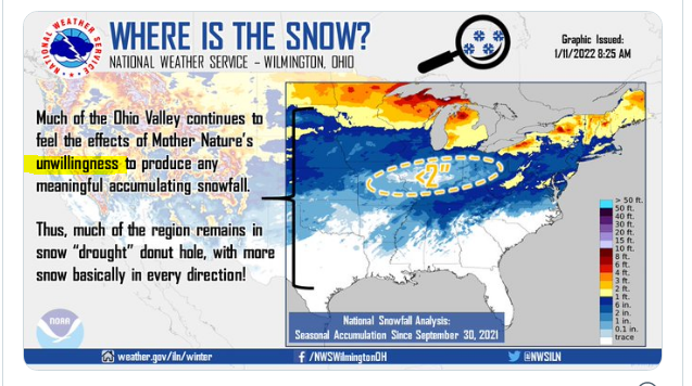
"Unwillingness" seems about right...
-
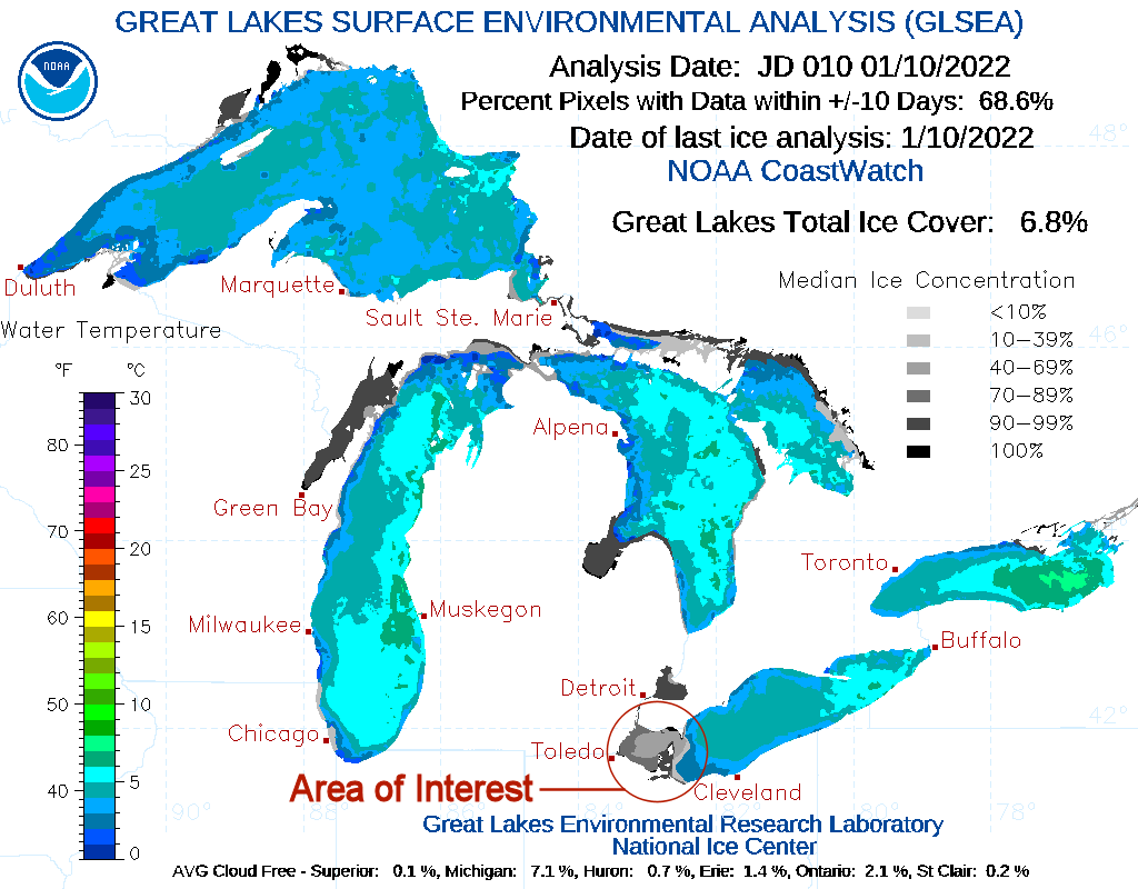
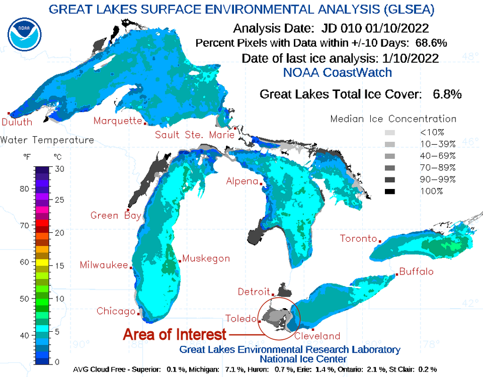
Most likely the ice has expanded since Sunday. 1) Image below is from yesterday; most likely from the early am before any major freezing took place. 2) Image below is my wild arse (WAG) guess of the current ice cover. Edited areas are within the red circle (Area of Interest). Note: Again, just a WAG from 30 years of watching similar western base ice cover spread over a similar 2-3 day sub-freezing temperature regime.

-
OHweather, Thanks for the post mortem. Yeah, this one sucked...I didn't know that stronger wind speeds over the lake added to the disorganization of yesterday's event. What do the elevated wind speeds do to lessen the effectivity of the snow bands? Also, what do you think of the synoptic storm early next week. The 12z GFS shows its track much further west and the 12z GEM shows increased accumulations (a chunk of that is lake effect/enhanced though. Seems to be a little more potential than the overnight models depicted.
-
I'll say! Here in Chesterland, we just got over an inch. Snow bands this afternoon were weird. They looked all sliced up. Was this caused by shearing at a different altitude? Looks like there is little moisture headed this way for the next week. Bone dry...
-
Latest ensembles do show some possible clipper opportunities in the next couple of weeks, so there's that. Caveat, all can totally change in 6-8 hours, Lol. However, there's been some persistence in the ensembles over the past day or two and the MJO looks, as of now, to stay in phase 7 and even 8 for the next two weeks. Optimistic here.
-
What's really weird is that we've really lost out a lot on lake effect. Part of the reason, IMHO, is the prevalence of a +NAO over the last several winters. With a +NAO, the trough axis tends to stay to our west and the resulting cutters only bring flurries as there is little residual moisture after a storm cuts into Wisconsin or Michigan. Also if LES conditions are better (more moisture and arctic air) a +NAO can result in a more WSW flow sending the LES to Buffalo. Note, the NAO was mostly negative in Dec 2020 and we had not one but two awesome snowstorms.
-
Interesting that NWS CLE has 1-2" Thurs nite and 1-2" for Friday. Would be nice if we could at least winter things up with 2-4" of snow. More snow forecast early next week, lasting from Sunday nite thru Tuesday.
-
Warm tongue of death (WTOD): eastward moving warm air hits the west Appalachians and is forced northward. Especially bad in the eastern 2/3s of OH. Storm doesn't necessarily have to be a Cutter to do this...
-
This upcoming event looks like a total dud. Look for the forecast accumulations to be reduced to the customary, as of late, an inch or less. A term I thoroughly dislike.
-
Don't forget Tennessee...
-
Yeah, for the most part it was a dry (relatively), disorganized event. Higher sun angles during the daytime at this time of year often enhance the convection/subsidence process creating these dumb fleeting cells when one minute it's a whiteout and the next, the sun's out.
-
A clipper is progged to bring some snow to Cleveland (CLE) area starting very early Friday morning and continuing throughout the day into Friday evening. I see Friday as having periods of rain, rain/snow mix and all wet snow later in the day. Friday evening, wet snow could accumulate 1-2", especially north of the Ohio Turnpike. Additional lake effect snow for the snowbelt (East Cuyahoga, Lake, Geauga and Ashtabula counties) could get anywhere from an inch in Cleveland's Eastern burbs (East Cuyahoga) to locally 3+ inches in Ashtabula county. ...Stay tuned...
-
As early as Wednesday afternoon, I didn't have a good feeling about this. Then, looked like the cold air adv. was a little slow and dry air adv. was somewhat aggressive. I smelled a bust. How big, I didn't know then, but I had my doubts about anything over 5-10". The LES cells on Thurs/Fri were disorganized/"pop-cornish" and fast moving which is common with late-season LES events. My best snowfall came on Friday Night when I picked up around 3". My storm total was 5-6".