

tarheelwx
-
Posts
1,709 -
Joined
-
Last visited
Content Type
Profiles
Blogs
Forums
American Weather
Media Demo
Store
Gallery
Everything posted by tarheelwx
-
Dry slots have been under modeled for 40 years since I began actively following the weather. The other thing to note is that the final line coming through with heavy precip will likely be with temps close to freezing. Heavy rates and a marginal surface temp will likely lead to additional accrual. Having said all that, this airmass is exceptionally cold and CAD often hangs on for dear life in key areas. TW
-
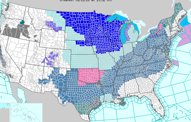
Does anyone remember seeing such a widespread map? TW
-
I'd say backside snow is exactly what we should expect to happen. TW
-
Maybe this has already been said, but just in case....... This starts in NC as an overrunning event that transitions to a miller B (most likely). In many overrunning events, precip arrives/breaks out a bit ahead of schedule. Don't be surprised to see the precip arrive Saturday morning vs. afternoon. I could surely see it come in 6-9 hours ahead of schedule. TW
-
What exactly does "Total Ice" mean on this map? TW
-
Check out this really cool site that shows rain, snow, sleet, and freezing rain all simultaneously. TW https://coolwx.com/cgi-bin/getptype.cgi?region=us&model=gfs&run=12&fhr=49&field=acctype
-
Can we al agree that an ice storm is caused by freezing rain and not sleet? The ice storm area will likely be far removed from the heavy snow line. TW
-
Most of that precip showing up as zr in NC will likely be sleet. Someone likely further south will surely have a BIG zr problem. TW
-
NVM, I got it. I typically don't dig that far into the models.
-
WXNEWTON, can you show a map? Thanks in advance. TW
-
Anyone else notice the lack of freezing rate being spit out by any of the models...... no CAD and not much low level cold air. TW
-
GFS is pretty close to where you'd want it at this point. TW
-
That 06z GFS was a real slop storm for the mountains. PLenty of qpf, but temps struggle to get down to or below freezing. Even after the storm, there's still no real intrusion of arctic air anywhere near the southeast. After the storm pass, we're right back to where we're at. As we all know, it is the GFS. TW
-
I haven't chimed in much at all this season. What has happened in the last week or so with a promising pattern disappearing has been all too common the last few years. Everyone gets worked up that it's coming as many of our "experts" are fully on board. The problem that I've seen is that these bullish forecasts for the holy grail pattern (or close to it) are based on 2/3/4 week ensembles and indexes that quite frankly are no better than a 10 day deterministic forecast. Throughout all of the excitement over the last couple of weeks, I just didn't see a whole lot there that looked promising. As in the past, I read what the "experts" were saying and remained optimistic. Here we sit on Jan 1 with the first 2 weeks pretty much shot. So, we'll likely have peak climo temp wise (Jan 15-30) still on the table for possibly having something good happen. After that, temps are headed north and it gets more difficult to have a classic winter pattern that would have snow on the ground for more than a day or two. It can certainly happen, but times like that are fewer and further between as time goes along. Happy New Year folks! TW
-
Massive arctic front moved through Greensboro Christmas eve during the day. Temps dropping into the single digits Christmas eve night. Greensboro had a high of 18 on Christmas day and a low of 1. Dec ended 6 below normal with a trace of snow, but ice on the 21st. TW
-
JB does have some good arguments though. TW
-
To me, it’s a trace of it falls. Saying it has to be white on the grass would be like saying you need at least something in the gauge for rain. I’ve just looked at a trace as almost nothing, but at least something fell. TW
-
6 weeks. Right through the heart of winter. Here it comes. On the other hand, we were cold last January, but had very little to show for it. TW
-
And the 18z GFS has a doozy leading up to Christmas for parts of NC. TW
-
Digital Snow/Ice Thread 2025-2026
tarheelwx replied to WinstonSalemArlington's topic in Southeastern States
That would be a good one. TW -
Listening to my weather radio this morning as I was getting ready for church, the forecast for the northern mountains was calling for wind chills this week of -120!!! It did this multiple times for the Tuesday-Thursday time frame. That’s a good one. TW
-
February 19-20 Major Winter Storm Threat
tarheelwx replied to NorthHillsWx's topic in Southeastern States
Light snizzle in Colfax. 28.2. 1" of fluff. TW -
February 19-20 Major Winter Storm Threat
tarheelwx replied to NorthHillsWx's topic in Southeastern States
That's what I was thinking. Not a whole lot to get excited about if you're more than 20-30 miles west of 95. TW -
February 19-20 Major Winter Storm Threat
tarheelwx replied to NorthHillsWx's topic in Southeastern States
It's all about the trend - 18z NAM increased total precip by 0.10" in GSO and Hickory and 0.20" in CLT. Hard to say about the 18z 3k NAM as it really didn't go out far enough @ 12z to compare. But through 54hrs on the 18z vs 60 hours on the 12z, they were very very similar. TW -
February 19-20 Major Winter Storm Threat
tarheelwx replied to NorthHillsWx's topic in Southeastern States
I'm thinking for the triad back to the mountains that for this to be good, it will be primarily a mid afternoon to Wednesday night storm. If it ends up wrapping up by 6pm like some models have shown, then I think totals will be on the lighter side. On the other hand, we have the 3km NAM and hopefully the HRRR was about to show something similar with precip expanding out west. TW


