RedSky
-
Posts
17,574 -
Joined
-
Last visited
Content Type
Profiles
Blogs
Forums
American Weather
Media Demo
Store
Gallery
Everything posted by RedSky
-
Experts have weighed in and say the correct permanent time change is to lose the hour of daylight So less afternoon daylight snow forever
-
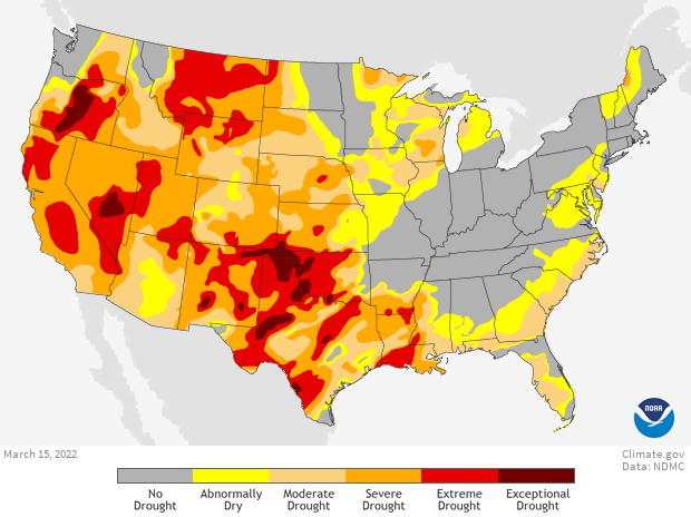
Had today penciled in as a rain out...oops drought taking care of that
-
GFS looks to have way way overestimated cold air the last 10 days of March, should have known it was the old bias. We still get a cold shot on the ECM but looks limited and late in the period.
-
Omg drought
-
Weather World has 20 of the next 28 days above normal and only one last cold shot late March.
-
North and south weather 2022 is hilarious * ECM very different drives the low into the lakes
-
Last 10 days of March look ugly The same damn pattern won't give it up guess April will get cold blasts too
-
Onion grass is everywhere
-
Not to be fooled by fake spring. Strong guidance indications of significant cold wave in the last five days of March. Possibly snow if a wave is timed right. Same pattern of more warmth than cold interspersed by a deep cold wave. The EKG pattern. In like a lamb out like a polar bear?
-
An extra hour for daytime snow forever woohoo!
-
No guidance has showers what is going on
-
A glorious 68F for the high
-
Blowing the doors off guidance it's 66F already
-
Rise of Mad Max, somewhere out there lord Humongous awaits
-
I celebrated without knowing it. Also gas prices are dropping, endangering family members prediction of $7 a gallon '
-

March 12, 2022 Snow Discussion and Obs: Winter's Last Appearance?
RedSky replied to Newman's topic in Philadelphia Region
5.5" total -
March 12, 2022 Snow Discussion and Obs: Winter's Last Appearance?
RedSky replied to Newman's topic in Philadelphia Region
The final squall line that arrived is better than the first one -
March 12, 2022 Snow Discussion and Obs: Winter's Last Appearance?
RedSky replied to Newman's topic in Philadelphia Region
On and off but mostly light snow with the squalls couple tenths maybe -
March 12, 2022 Snow Discussion and Obs: Winter's Last Appearance?
RedSky replied to Newman's topic in Philadelphia Region
Moderate snow blowing and drifting 24F -
March 12, 2022 Snow Discussion and Obs: Winter's Last Appearance?
RedSky replied to Newman's topic in Philadelphia Region
Never saw a radar popcorn presentation like this wow https://weather.cod.edu/satrad/nexrad/index.php?parms=PBZ-N0Q-1-24-100-usa-rad -
March 12, 2022 Snow Discussion and Obs: Winter's Last Appearance?
RedSky replied to Newman's topic in Philadelphia Region
Popcorn variety like a Regal theatre exploded -
March 12, 2022 Snow Discussion and Obs: Winter's Last Appearance?
RedSky replied to Newman's topic in Philadelphia Region
It has begun to snow again 26F -
March 12, 2022 Snow Discussion and Obs: Winter's Last Appearance?
RedSky replied to Newman's topic in Philadelphia Region
Sure it won't effect Bucks eh ^ ^^ -
March 12, 2022 Snow Discussion and Obs: Winter's Last Appearance?
RedSky replied to Newman's topic in Philadelphia Region
It's happening... (place Ron Paul gif here) https://weather.cod.edu/satrad/nexrad/index.php?parms=LWX-N0Q-1-24-100-usa-rad -
March 12, 2022 Snow Discussion and Obs: Winter's Last Appearance?
RedSky replied to Newman's topic in Philadelphia Region
NWS thinking 1-2" with the snow squall activity this afternoon interesting URGENT - WINTER WEATHER MESSAGE National Weather Service Mount Holly NJ 1248 PM EST Sat Mar 12 2022 NJZ001-007-PAZ060>062-101-103-105-130000- /O.CON.KPHI.WS.W.0005.000000T0000Z-220313T0000Z/ Sussex-Warren-Berks-Lehigh-Northampton-Western Chester- Western Montgomery-Upper Bucks- Including the cities of Newton, Washington, Reading, Allentown, Bethlehem, Easton, Honey Brook, Oxford, Collegeville, Pottstown, Chalfont, and Perkasie 1248 PM EST Sat Mar 12 2022 ...WINTER STORM WARNING REMAINS IN EFFECT UNTIL 7 PM EST THIS EVENING... * WHAT...Snow. Additional snow accumulations of 1 to 2 inches. Winds gusting as high as 50 mph. * WHERE...Portions of northern New Jersey and east central and southeast Pennsylvania. * WHEN...Until 7 PM EST this evening. * IMPACTS...Travel could be very difficult. Areas of blowing snow could significantly reduce visibility. Gusty winds could bring down tree branches. PRECAUTIONARY/PREPAREDNESS ACTIONS... If you must travel, keep an extra flashlight, food, and water in your vehicle in case of an emergency. The latest road conditions for the state you are calling from can be obtained by calling 5 1 1.