Hurricane Agnes
-
Posts
9,263 -
Joined
Content Type
Profiles
Blogs
Forums
American Weather
Media Demo
Store
Gallery
Everything posted by Hurricane Agnes
-
I was watching that. Always thought that was cool. Made it up to 65 today and the dp was still hanging in that mid-60s. Currently partly cloudy and 79 with dp 66. As a side note, I ran the 18Z GFS and it picked up what looks like another tropical cyclone in the GOM and aimed it at TX right at the end of the run! Sounds like it is getting warmed up for winter.
-
If you have any frontal passage corresponding with it as it approaches, the moisture could get entrained in that to produce an overrunning event, regardless of whether we get a direct remnant hit or not. This is what Ian did last year - Et voila! Between Sept. 30 - Oct. 5, I had 5.02" of rain from that! Similarly, Ida gave me 5.41" of rain the year before on Sept. 1 And in 2020, Isaias deposited 4.39" here on Aug. 4. And although the "S" word storm was the big one for people, Hurricane Issac gave us a little love in 2012 - I always keep an eye out for "I" storms around here (think "Irene", "Issac", "Irma" (got some splats), "Isais", "Ida", "Ian"). As an obs, I think I have finally bottomed out at 67 and it's currently a partly sunny 68 with a lower dp (finally) of 64.
-
Looks like our soon-to-be-a-(Philly Special)-"I" tropical cyclone is in the making (just became a TD). Had a low of 71 this morning and made it up to a humid 87 for a high. It's currently a partly sunny and still-humid 84, with dp 70.
-
What was probably more amazing was that D.C. didn't get their 1st August 90 until 8/12. I ended up get mostly fringed by the rain so far (although I'll take what I got which was more than nothing). Had 0.12" late last night and then another 0.19" on and off this morning for a 2-day total of 0.31". Had a low of 68 and it's currently mostly cloudy with breaks of sun, and a humid 83 (my high so far) with dp 74.
-
Hit 80 for a high yesterday after a low of 61 and decent dps for late August. Am hoping for some rain too and will see what happens with that big MCS sitting back over OH. Currently overcast and 68 with dp 62.
-
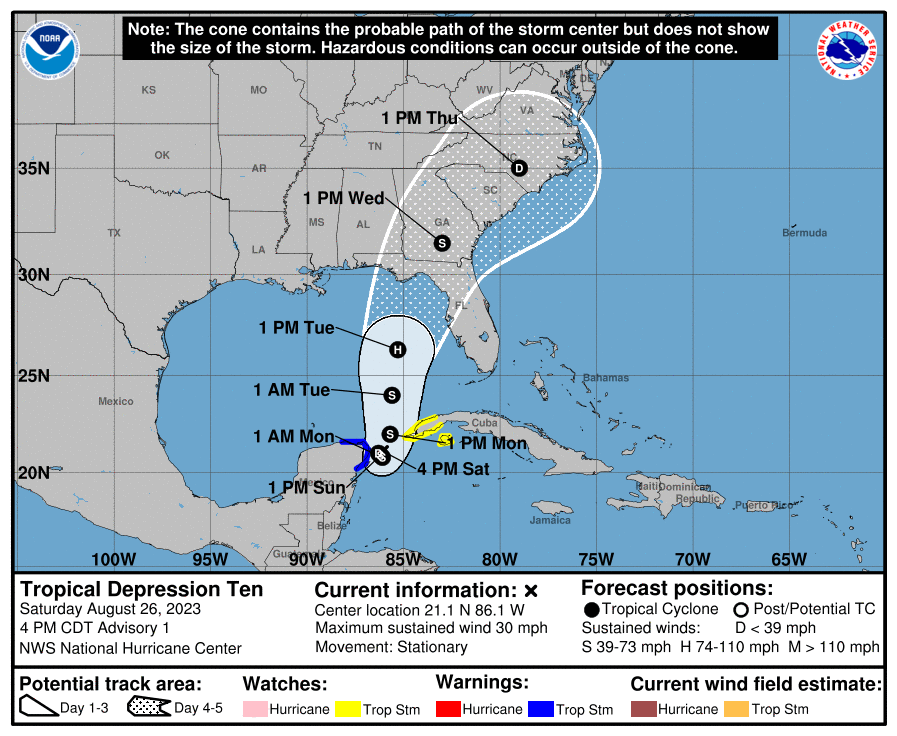
Of course not related but can you imagine how many are there who haven't had the experience of a TS (or remnants) and then have an earthquake accompany it?? Thing is, if there are road/surface cracks from that plus the rain, it's going to be a mess. WPC seemed to think there would still be hazards associated with it all the way through Wednesday (that latter timeframe further north). Am thinking that if there is still circulation going, it could pull moisture in bands off the ocean out of the NW as the storm pivots. And speaking of rain, what little I got the past week meant I had to pull out the hose today. I am watching the Atlantic that suddenly exploding into being with 2 tropical storms forming and a potential right in the bath water GOM that is about to pop off so will see what happens with at least that one (if it doesn't get sheared apart).
-
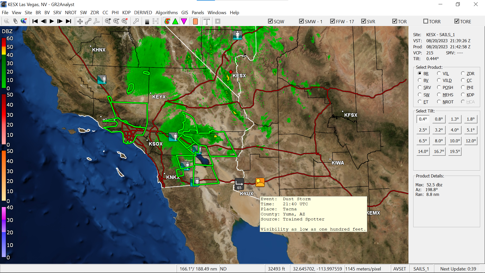
They had to top it off with a 5.1 earthquake as Hilary was lashing the area. There were even some dust storms popping up in AZ. I ended up with my coolest low for August so far - 59 - and made it up to 86 for a high. I think the high clouds and what was supposedly some wildfire smoke way up high, kept the temp down. The dp did creep back up into the mid-60s though. The circadas were going this morning though and I also saw a cicada killer ready to find one too. Currently partly sunny with some haze and 80, with dp 65.

-
Ended up with a high of 87 yesterday and a muggy low of 66 this morning, with 2 minuscule rounds of rain this morning, with 0.03" sometime between 2 - 3 am and another round of 0.07" after 6 am for a total of 0.10" for today (3.23" for August). There was a battle of the air masses this morning as the dps in the 70s fought back hard but were finally vanquished by mid-morning, dropping into the 60s. And now after hitting 82 as a high today, it's currently a partly sunny and breezy 75, with lots of cumulus, and a rare dp of 54.
-
Had a little line come through the city this morning and I managed to scrape 0.18" from it (total now 0.25" over 3 days and 3.13" for the month of August). Currently overcast and at my low (so far) of 72, with a steamy window morning thanks to the dp of 72.
-
Got another 0.02" for a total of 0.04 for the day (so far) and 0.07" over the past 2 days. Monthly total is 2.95" to date. Currently 76 with dp 75.
-
Finally got enough of a fringe to get another 0.01"! I'll take it I guess (as I watch the cell scoot round me to the south and then blow up again to my east).
-
I have been getting fringed by the dissolving cells. Right now I have a wet walk but no measurable. The high ended up being 89 and I'm currently mostly cloudy with a break of sun, and 81 with dp 76.
-
What looked promising last night when I went to bed, was a bust here. Ended up with 0.03" yesterday and 0.01" today (around 5 am-ish). Had a warm low of 75 this morning and have so far hit a high of 89 today. Currently mostly cloudy and 88 with dp 75.
-
And here we go -
-
Had been getting some drive-by sprinkles enough for 0.03". Currently mostly cloudy and 72 with dp 69.
-
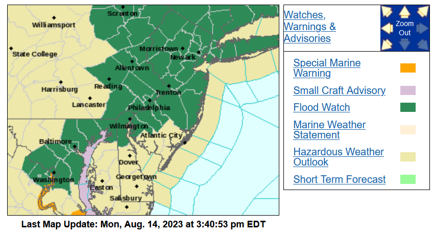
Flood Watch up for much of the CWA - Had a low of 66 this morning and surprisingly hit 90 just before 2:30 pm (had expected to hit that the previous week). That makes my first 90 of August and my 13th of the season. Currently 86 and mostly cloudy with dp69.
-
Power back at the original earlier estimate of 12:20 am. YAY! I did have my station console on a UPS. Currently 71 with dp 66.
-
PECO's map now has a 1:30 am est. restoration time and listed the cause as "down trees and limbs". LOL My electric is underground to the house but obviously that is meaningless if wires have to go above ground to poles eventually, in order to get to a substation. It would have been a good night for Perseids viewing with all the lights out around the area which I tried and got treated to a deck of cirrus. At least I did hear the katydids going, although not many crickets for some bizarre reason.
-
Well starting at 9:59 pm, my whole area here in Chestnut Hill along with much of Wyndmoor, had the power go out. There is clear weather. Power is still out.
-
Ugh. I know where my sister is in Wyndmoor, the last nasty storm, all the houses across the street from her were out. Her block had the electric poles and wires carefully placed decades ago when the houses were built, so they would be "hidden" among trees that were set along a strip of what was a township easement. Fast-forward like 60 years and it's literally been a nightmare storm after storm, with PECO sending Asplundh out to prune branches and whatnot. Most of the time it ended up being her side out because the poles were set along a creek and surrounded by trees. The 68 did end up being my low this morning and I made it up to 88 as a high. It's currently a breezy and mostly sunny 84 with dp 66.
-
Got warned overnight and apparently a lot sound and fury signifying nothing here, with no measurable rain. Most seemed to have gone north of me. Did try to peep out earlier this morning and there was cirrus with some breaks enough to see stars but not really as clear as hoped if wanting to catch any stray Perseid streaks that would be visible from the city. I did see a cool crescent moon rising though. Currently partly sunny and 68 (my low so far) with dp 67.
-
That southern blob looks like it's headed for the ballpark. I think the game starts at 6:05 so it might hit there before game time. RedSky might be getting fringed by the northern blob.
-
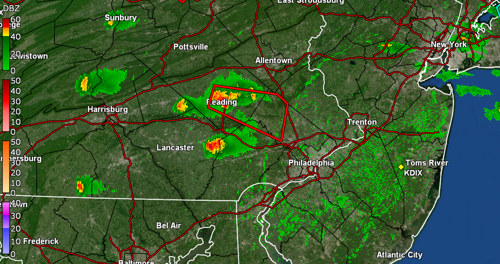
That is getting warned right now. Currently partly sunny and 84 with dp 74 IMBY.
-
Captured a recent frame that looked like it was trying to do something but it seems to have dissipated a bit.
-
You lucked out. Those storms generated an outflow boundary that came barreling over me from SE to NW but it didn't really drop my temps much. My temp is back up to what is currently my high of 85 with dp now 76.