Volcanic Winter
-
Posts
1,674 -
Joined
-
Last visited
Content Type
Profiles
Blogs
Forums
American Weather
Media Demo
Store
Gallery
Posts posted by Volcanic Winter
-
-
Nothing like starting your day with a lovely intraplate mag 4.8 quake. Shook Hillside pretty good!
Lots of ancient buried and inactive faults around the fall line from when we were stapled into Pangea. They can occasionally still groan and shift enough to produce quakes like this, though they aren’t super common. Pretty cool!
-
Dropped all the way to 21F early this AM.
-
On 3/20/2024 at 10:06 AM, Brian5671 said:
Embarrassing at this point...the twitter comments are hilarious....
“Ice age when?”
Reminds me - a couple years ago I stumbled across a climate change denial website, I think it was called ‘Electroverse.’ It was dedicated to talking about the impending ice age that’s happening any year now lol. Of course they were obsessed with the “Grand Solar Minima” that never materialized, and kept posting any cold temperature records from any specific town or village anywhere in the world on any given day. You know what they say, weather = climate right? Definitely.
Good stuff, still waiting on my Ice Age. We know that’s my preferred climate configuration, but unfortunately I think the past two years went in roughly the exact diametric opposite direction. Wondering if that site’s still truckin’, I’d imagine they dropped the solar stuff given how spicy the sun has been, and probably focused on Asia this winter. -
28 this morning, still only 33F at my house. Impressive given the rest of this month.
If tonight is clear and calm my house should go into the lower 20’s.
-
 1
1
-
-
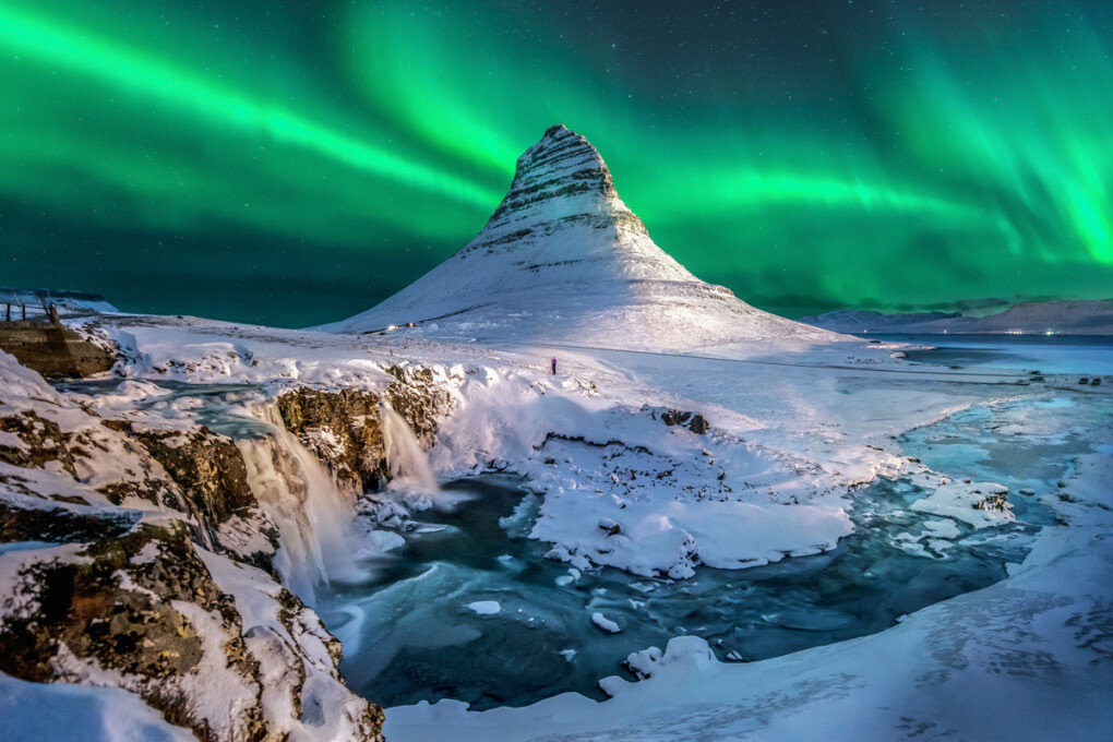
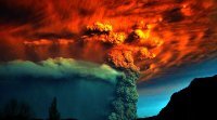
Iceland cracked open again for a continuation of the fissure eruption near Grindavik. Some spectacular images from this event.
An Icelandic volcanologist predicts that the activity will ultimately start to lessen by July, and at that point we may see the activation of another system or even see it switch back to Fagradalsfjall.
-
Add to that both Katla and Hekla are due for explosive eruptions any time now, and the monster Öræfajökull (Or-eye-fa-yo-koolt) showed activity / inflation beginning in the 2010’s (its last eruption was in the 1700’s and it theoretically could be nearing its next one).
Katla is a bit more concerning as it has surpassed its normal length of dormancy (Katla is typically very regular with its frequent large VEI4-5 eruptions), which could point to a larger VEI 5 event forthcoming. Hekla may also be nearing a larger event, though unlikely to be larger than Katla.
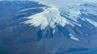
Öræfajökull is the explosive wildcard as this volcano at the southern axis of the Vatnajökull glacier is the largest explosive volcano in Iceland and contains the highest peak in the country on the rim of its glacier-capped massive caldera (Hvannadalshnúkur). It’s capable of anything from VEI 4 to 6 eruptions, and tends to only go large when it does erupt. That system waking up would be downright frightening. So much so, the volcano had a different name amongst the original Icelandic settlers prior to its borderline VEI 5-6 eruption in the 14th century, and after had its name changed to mean “wasteland.”
-
 1
1
-
-
14 hours ago, etudiant said:
Keflavik airport is at the end of the peninsula. If it gets isolated by these eruptions, it would be crippling for Iceland, tourism is a huge part of the economy.
Are there any contingency plans that have been prepared or are they confident that these eruptions will remain contained?
I mean, AFAIK they’re responsible for the first successful artificial structure based lava flow redirection in history. While the wall they built north of Grindavik was ultimately breached, it was moreso because a small fissure opened up inside of it which is something they’re not going to be able to control. Still what they did to divert the flow around town was mightily impressive considering the destructive force of lava. Those walls will not work in a faster, higher effusion rate eruption though as they’ll quickly be swamped.Ultimately I think they were piloting these diversion structures to help protect important assets going forward. A few of the Reykjanes systems are pretty violent and did very large hrauns (lava fields) in the Middle Ages. Eldey and other systems near Keflavik have had phreatomagmatic (explosive) components in the past, including tephra fall over the location of Keflavik today.
Going forward the risk is uncomfortably high, though unnervingly spread out over a long period going forward. The Reykjanes cycle in the Middle Ages was something like 300 years of on again off again activity throughout the various volcanoes on the peninsula, and evidence suggests a similar thing will start to (and already has) happen now.
Hengill is a monster and could present a problem for Þingvellir and the Golden Circle tourism hub east of the capital.
Unfortunately, despite incredible advances to predictive ability in the last few decades, this is still highly inexact and the protracted risk going forward to the capital region is substantial.
-
1
-
-
21 hours ago, snowman19 said:
Going to be a rough 9 months coming up for him I guess lol
Anyway, everyone enjoy your weekend, gonna be off the grid for a few days, wedding festivities the next 2 days, starting with the rehearsal dinner tonight….
Congratulations Snowman! Wishing you and your significant other the best.
-
1
-
-
Should be another imminent fissure eruption near Grindavik in Iceland. They can’t catch a break. This is going to keep happening for some time, as this form of volcanism brings repeated intrusions of magma that lead to repeat eruptions. And it’s not really ever going to be a type of eruption that Iceland can turn into a major tourism event like the gentle and predictable Fagradalsfjall eruptions the past few years.
And this is still all part of the opening salvo of the Reykjanes volcanoes waking up for a new cycle of eruptions. Systems all over the most populated peninsula in the country will continue to wake up and erupt over the next century or two.
Many of the towns on the Reykjanes including parts of modern Reykjavik are built on lava flows from the Middle Ages cycle of activity, so yeah going forward this is going to be quite a challenge for them.
-
2
-
-
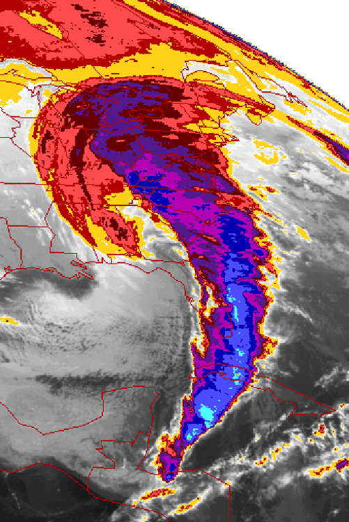
Absolutely crazy storm. The entirety of the comma extending down past the Yucatán is just awe inspiring. Absolute beast.
I mean just look at it:
-
2
-
1
-
-
8 hours ago, LibertyBell said:
Yes and the allergies aren't bad yet either!
I have allergic rhinitis and it’s one of the most unpleasant things I’ve ever experienced. Nasal passages swollen shut, feels like I’m breathing through cocktail straws. Thankfully Nasacort works very well for this. I actually have it all year round but of course it’s always worse in the spring.
-
1
-
-
The reality of the present situation is that those who still stand opposed and defiant to global warming will see their convictions tested by the sheer force of overwhelming reality. I suspect outright rejection will shift to the common “it’s just natural cycles, the earth’s always changing” fallacy that’s already increasing in prevalence as more people accept that the planet is warming.
The problem with the latter argument is that there’s a kernel of truth to it, but proponents typically lack the knowledge to properly contextualize natural climate change with what’s been observed in the past hundred years. So I suspect that form of denialism will be the toughest to overcome, but it’ll eventually happen. The problem is simply that it needs to happen now, it’s already too late in the sense that massive warming is already “locked in.”
I’ve never been an optimist about this, the reality for me has always been it’s going to get really bad before enough people globally are onboard that there’s any meaningful shift to carbon policy. Meaningful in the sense of substantive result.
Gonna be interesting, to say the least.
-
I’m not well versed in African climatology but this seems a little extreme to me for March:
https://watchers.news/2024/03/12/thousands-of-high-temperature-records-broken-across-africa/
-
1
-
-
2 hours ago, Will - Rutgers said:
gonna be begging for this weather in a few months
we are hitting an 80 dew this year in nj i feel the power
Dew not want.
-
2
-
-
2 hours ago, bluewave said:
That was the only winter that I experienced which could be compared to the little ice age before the global temperatures took off like a rocket after 1980. Walking to the school bus stop was quite an experience. It was the last time NYC had a top 10 coldest winter averaging in the 20s.
Yeah I can’t even imagine, that does appear to have been a close facsimile of a LIA winter. If a similar pattern regime were to happen today, how modified do you think the airmass would be? Would think it’d still be significantly colder than any recent winter just not to the level of 76-77.
I do think we’re more than due for a winter with a colder pattern locking into the east, but perhaps the Pac temp regimes are unsupportive of such a thing happening, and who knows when that will change.
I’’m at the bargaining stage. Just give me one extended, relative “cold” winter compared to this post 2016 hothouse phase and I’ll be satisfied.
-
Really fascinating paper on the winter of 76-77, the last time the Chesapeake froze. Has some maps from other cold 20th century winters. Good read:
http://nwafiles.nwas.org/digest/papers/1977/Vol02No4/1977v002no04-Wagner.pdf
-
37 minutes ago, forkyfork said:
these temps in march are unimaginable now
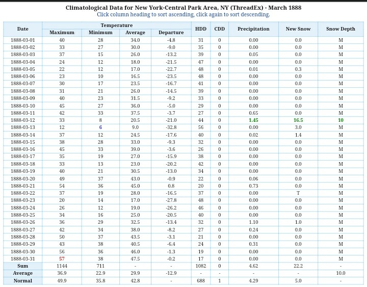
The minimums in particular are jarring. Even in the pines I haven’t been able to get below freezing since March 1st. March 8th I hit 33. Totally different regime in a totally different era, it’s just fascinating by comparison. 29 average for the month? That’s DFa climate criteria satisfied in March, lol.
I would kill for temperature data like this during the Little Ice Age, especially the peak and heavily volcanic perturbed years. Some of those winters had to be damn near polar by comparison to today, regardless of how much snow fell (I would assume significantly more by way of increased frequency of small to moderate snowfalls but that’s just a guess. Maybe it was cold and dry more regularly, mimicked on a smaller scale in the 70’s and 80’s).
-
That is absolutely remarkable, like the Pac let loose an enormous heat burst in 2016 that has persisted since. I guess the oceans taking up the majority of warming eventually have to release that latent heat, perhaps it doesn’t happen linearly.
-
15 minutes ago, Snowlover11 said:
fun drive into work, it’s already shitty out, you then have people cutting you off for no reason when they have three other lanes to drive in.

Wife just drove home from Metuchen in a deluge complete with typical NJ Parkway driver nonsense. She has bad eyesight and goes slow in the rain at night - in the right lane, always. People were still cutting her off and riding right up on her bumper.
C’mon guys you have like 7 other lanes to choose from.
-
1 hour ago, MJO812 said:
Same here in Dyker Heights
14 inches
Nice! You beat me dude, 11 on the season down here, very lucky to have had accumulating snow on a few different days. Feels like a victory for how intensely warm and overarchingly mild this winter was though. Very happy that first Jan storm did a number on the northern Metro and that last Feb event deathbanded CNJ. Made an otherwise poor winter tolerable for many I’m sure.
-
My wife and I are planning our Iceland trip next year, we’re going to go the day after Xmas through New Years. Celebrating 15 years together (crazy, we met very young for this day and age). Gonna plan out a few awesome winter hikes and really make the most of it, and being in Reykjavik around the holidays is magical.
If winter won’t come to you, go to winter. IB4 front loaded Niña Boxing Day redux hitting as our plane takes off from EWR

-
4
-
-
50 minutes ago, jm1220 said:
The place that’s really due is SE FL from PBI to Miami which hasn’t really been hit since 2005 by a major. Up here it seems like the tropical systems come in waves like 2011-12, and 1938-54. We probably are due for another storm like Bob that hit eastern LI and New England hard.
For sure, I was just thinking with respect to our region.
I follow hurricane season pretty closely since I was a kid, and I have now elderly parents living on a barrier island so my sister and I help keep them safe. They were tremendously lucky in Sandy though they weren’t able to go back to their home for months.
-
We’re probably “due” for some landfalling tropical systems up here. We’ve really only had Isaias (which I remember as pretty wild given what it was at the time) and the remnants of Ida which of course spawned the great NJ EF3 and associated outbreak, along with crazy flooding in the northern metro. Perhaps this year we see more east coast / northeast landfall risk?
Always thought it was pretty wild how we had Irene and Sandy back to back, the former a significant impact and the latter historic. Probably sooner or later we’ll see the next one. I do enjoy a good tropical system (hurricane parties are fun, we evacuate my parents out of Seaside and gather at my sister’s place inland). But I think the risks from a Cat 2 + are probably too great to really be exciting anymore, probably more when I was a kid. It’s been a while since we’ve had a stronger storm up here, you’d think it’s a matter of time with the warmer SST profiles in the Atlantic. Just need a relatively fast mover without too much prior surface churn.
Think my oldest tropical system memory was when I was a little kid at my parent’s place in Seaside while Bob scraped by the immediate coast. Pretty sure that’s the one I remember though ofc it wasn’t a big deal here.
-
38 minutes ago, MJO812 said:
LOL
I love snow but I also like cool and rainy days .
You do you man. I love the cool temps through March but could probably do without the rains that inevitably make my Parkway commute a disaster. Had a guy doing 45 in the left lane with their hazards on and people zooming around him at 80 - in downpour level rain. Brilliant! Oh and a few accidents of course, likely because of stuff like that.
I just want climo cool days without the endless deluge, more normal rainfall patterns don’t bother me though.
-
1
-

Extended summer stormlover74 future snow hole banter thread 23
in New York City Metro
Posted
That quake was in Virginia. We were much more proximal to this quake.
Ascertaining the exact epicenter, magnitude, and depth is somewhat inexact and gets refined when data is reviewed after the fact.