
Volcanic Winter
-
Posts
1,674 -
Joined
-
Last visited
Content Type
Profiles
Blogs
Forums
American Weather
Media Demo
Store
Gallery
Posts posted by Volcanic Winter
-
-
Congrats man! Amazing!
All the best
-
 1
1
-
-
A reminder that nothing we say impacts the weather, but I would always take a cool to cold March. The rest of the year is almost uncomfortably warm for me anyway and everyone will get their warm temperatures regardless.
It’s funny, I would never go to Florida on climate grounds alone. Much too hot and humid for me. I derive very little enjoyment from summers here, my body just doesn’t tolerate heat well and I don’t like hiking in the bright sun. Nothing beats cold weather outdoors time for me, Nov through March is usually when my wife and I do the most outdoors stuff though my wife enjoys warm weather more than I do
Again, I’m a very atypical person and I admit that. I’m one of those that would live and work in Antarctica had I the opportunity. We also do a lot of cold weather travel and are extremely well prepared for it, having the right gear for the cold makes a tremendous difference in comfort. But regardless I’m just very attuned to cold weather and it makes me feel alive in ways the heat makes me want to stay inside.
At some point if we don’t outright move we’re going to try and get a place in the NNE mountains to escape in the summers at least, then visit in winter. One day.
-
5
-
 2
2
-
-
We got our revenge. It finally came.
-
 1
1
-
-
I’m at about 44-45 (about an inch overnight, so call it 45) on the season.
I’m Toms River but at the Manchester border to the west, the east part by the river / Barnegat Bay may have different totals. This area can have fairly significant differences between Seaside , TR by the bay, and over to me.
Like for the storm I saw Manchester had 19 inches and TR reported 23, which I believe is measured in the eastern part. Predictably I about split the difference between them.
-
1
-
-
8 hours ago, MJO812 said:
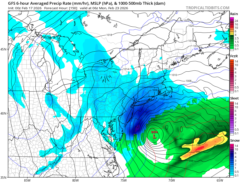
This was 0z gfs on Tuesday. Insane how it kept the same solution or tweaked it .
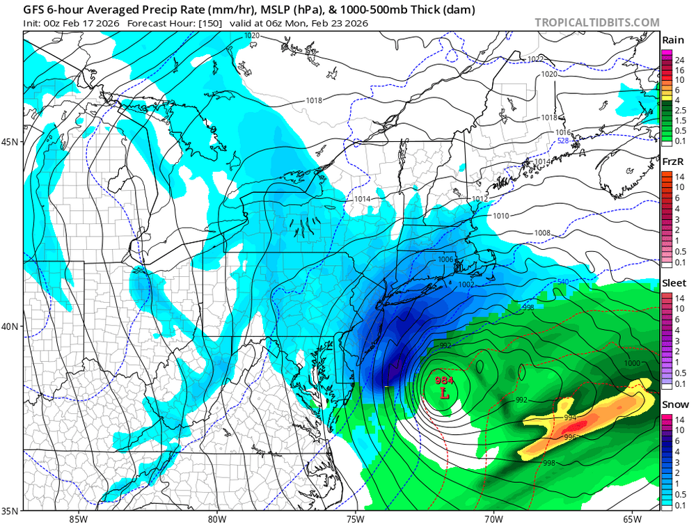
The GFS was lights out on this storm and it’s amazing to me. It was at best frustrating throughout the rest of winter but it saw this storm and never lost it, never compromised the outcome and just kept full steam ahead with NAM 2016 energy.
Taking this with the usual AI grain of salt but GPT-5 explained it that the Euro’s verification scores have the most to do with H5 synoptic performance and that sometimes the GFS is better able to resolve northeast coastal systems at lead.
Good but, it’s not like the GFS did great to my memory with the other systems this winter, it was all over the place IIRC.
Seems like it’s becoming more difficult to parse which model has the best read for any one event.
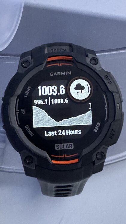
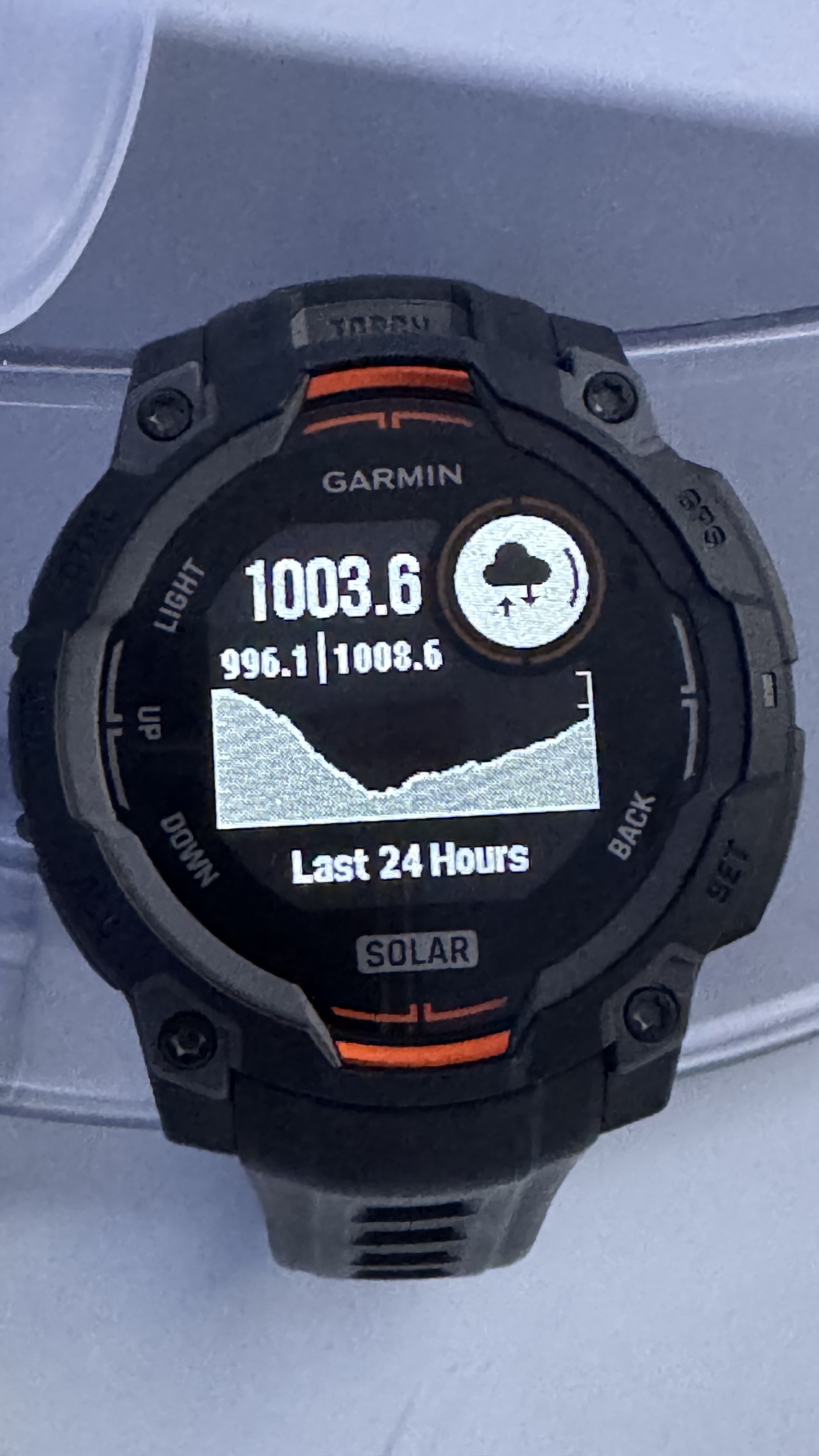
Edit: Here’s my Garmin Instinct 3 barometer log throughout the storm just for fun
-
1
-
-
44ish on the season. Definitely a classic KU with that “big dog” vibe throughout. 1/25 in my area was totally bonkers as a 10 inch event capped by major icing that persisted for weeks, my parents in Seaside had ice skating rink quality ice on the ground for 3ish weeks (had shoveled up the snow and the ice fell last, after we had to leave). Significant and long lived cold spells despite some mild periods and warmups.
Yep this is a good winter. TR had like 74 inches in 2009 but I wasn’t here then, but this is absolutely the best winter since the 2009-2015 block down here.
Kind of winter I’ve been sorely missing and we all needed to balance the scales a little.
-
1
-
-
1/25 was most comparable to what, 94? This is a classic KU HECS but 1/25 for some areas was mental also with 10+ inches and several inches of accumulated ice. I need to upload my video of ice picking away my parents house in Seaside for a week straight and the shards of ice I was ripping up off everything.
Not everywhere had that component the same way, different than just a sleet slush bomb. Then the temps…
-
-
-
-
We’re around 18 on the stake, but blowing snow complicates. It’s quite a bit. I’ll get out shortly and do a better assessment.
-
Was watching those yellow bands rotating into SNE last night and was happy for you guys, hope the storm finishes well for you all!
-

Already shoveled somewhere around 10-11 inches last night. We’re around 18-19 on the stake but lots of blown snow and slightly slant sticked from weight and wind.
-
1
-
-
30 minutes ago, nycsnow said:
So anyone taking a power nap or pulling all nighter?
I had to pull my elderly parents out of Seaside and they’re staying with me, keeping an eye on them and staying ahead of the shoveling - I’ll likely be up all night. Haven’t had much time to enjoy the storm or track / catch up here, but family first of course. Wife has been a tremendous help and a trooper because my parents are a lot a lot.
My sister lived in the area but moved to the southeast this past year on little notice, so I’ve been their primary caretaker since. Makes snow a bit less fun sadly, double house duty at a minimum.
-
5
-
-
People can have their opinions, we don’t need to attack them for not saying what we want them too. Frankly it’s what I dislike about some of the other boards here.
What is going to happen is irrelevant to what anyone on here says or thinks, so allow people the courtesy of their own take. I don’t know why that always ends up threatening to some - IE not hearing what you want to hear leads to mocking, which reads defensive.
-
4
-
 1
1
-
-
11 minutes ago, psv88 said:
I’ll report from Miami beach where wind chills are supposed to be in the 30s Monday night
Stay safe
-
1
-
-
Accuweather had me at 6-10 all day while also linking to the official 20-24 inch Blizzard warning.
Bit of a disparity.
-
2
-
-
5 minutes ago, nesussxwx1 said:
Toms River is consistently the bullseye on all models.
It’s okay guys, I’ll take this one for the team.
-
3
-
-
22 minutes ago, Santa Claus said:
accuweather minutecast lol
Sometimes it’s good to know what to expect in precisely 11 minutes.
-
Accuweather going super conservative still calling for 6-10 inches here with a blizzard warning underneath for 20-24. Wow, I’ve never seen a disparity like that and I’ve always considered Accuweather decent for snow - they must be very bearish.

I’m in Seaside at the moment with my parents but same in TR / Manchester, 6-10.
-
6 hours ago, Santa Claus said:
whichever way it goes this is an all-timer for the GFS, you’re going to hear “remember feb 2026?” at some point every winter the rest of your life
Didn’t the GFS hold onto the follow up storm after 1/25 a bit too long as well? It was the last to trend out to sea; that was definitely in my head all week. Expecting it to finally cave, and it didn’t. Crazy times.
-
Just now, JustinRP37 said:
Sigh, reading this tonight, and it is clear even many long-time posters are just making definitive statements that just were not true. Declaring any model victorious 3.5+ days out is just wild. The EURO is NOT infallible, just like the GFS. Models are human-made and thus not perfect. Weather models are literally attempting to predict the future. There are so many components that can cause so much to go wrong. Each model does have strengths and weaknesses. The GFS does tend to do well with northeastern storms. Sure, it isn’t perfect. We have had big letdowns even within a day. I’ll never forget years ago watching the rain/snow line heading further north than any model had it, and instead of over a foot of snow, we received a few inches. We should talk about patterns and systems and try not to let emotions cloud judgements. Just judging by the tenor of the threads lately, it seems many are ready for spring. But let’s see where things go. Plenty of solutions still on the table.
Totally fair, just for my thinking the parallels to the follow up storm a week after 1/25 are undeniable.
Of course hoping for a better outcome.
-
1
-
-
Not caught up in the thread but wow 18z Euro has a shift west + a healthier northwestern precip shield. I had just told my wife to write this thing off, not about to believe the GFS on an island again.
Positive development if this repeats next run. Euro has been locked in on nothing.
-
2
-
 1
1
-
-
Today was a pack destroyer down here, no doubt. Lucky that it was such a moisture-packed glacier, holding onto about 3-5 inches of actual pack. Piles still going strong, that’s gonna take a lot more to melt through. 9-10 days have been above freezing this month so far, just really excellent retention this year - the deep freeze damn near turned it all to stone.
Back down to 28f.
-
1
-


The Allsnow Blizzard of 2026
in New York City Metro
Posted
Absolutely incredible work, thank you for your efforts!
I still can’t believe this storm happened, it’s almost surreal. The uncertainty, the Euro pivoting towards the GFS, then knowing it’s coming and the buildup to it, ugh such a dopamine kick. The storm itself was incredible, marred only slightly for me by familial duty (had to take my elderly parents in, couldn’t fully enjoy the storm while it was occurring).
This was 1/29/22 better maximized and more NW. I do see similarities looking at this map, but this was the better storm for more of us.
Definitely a very memorable event, to say the least. I’m very happy SNE got crushed, the areas that really maximized were more than due, and that’s a hell of a debt repayment.
Spent a decent part of the last week in a dopamine crash since it ended.