

CT Valley Dryslot
-
Posts
317 -
Joined
-
Last visited
Content Type
Profiles
Blogs
Forums
American Weather
Media Demo
Store
Gallery
Posts posted by CT Valley Dryslot
-
-
Just now, dendrite said:
The only credit I remember the JMA ever getting was for Feb 06.
And Boxing Day, 2010.
-
Just now, dryslot said:
It also save you guys from locking the thread and starting over.
Some other forums would have locked it by now.
-
I feel bad for Kuchera and his last name being objectified.
-
1 minute ago, IowaStorm05 said:
My Dad lives in West Hartford and asked how much snow he should expect. I told him that nobody really knows at this point. That he could get 8 inches or get almost nothing at all. What I also told him is that I CAN say that it is very unlikely he will see anything like 15 or 20 inches as just about nothing is signaling any such thing, and to get a blockbuster there would require a f'cking miracle.
My father, no matter the storm, always says it's a bust.
He said Nemo was underwhelming.
-
 1
1
-
-
Honestly I think you're fine for warn snows along and east of 84.
Litchfield, Berkshire, Franklin, Hampshire and Hampden Counties are perhaps in jeopardy.
-
 1
1
-
-
Just now, weatherwiz said:
The freakouts are getting a bit ridiculous. This is still really 2.5+ days away. I know it seems plausible to want to see such strong agreement and consistency but the truth of the matter is we're still within the time frame where subtle differences are going to occur. Forgetting about these east vs. west swings, at the end of the day, we're not asking for significant changes here. For things to come together and be a very high-impact event for most...it's not like a ton has to happen for that to happen. There is a difference in needing drastic or substantial changes and very subtle.
A 40mi shift either direction can still happen and would have major implications for the whole board.
-
4 minutes ago, ineedsnow said:
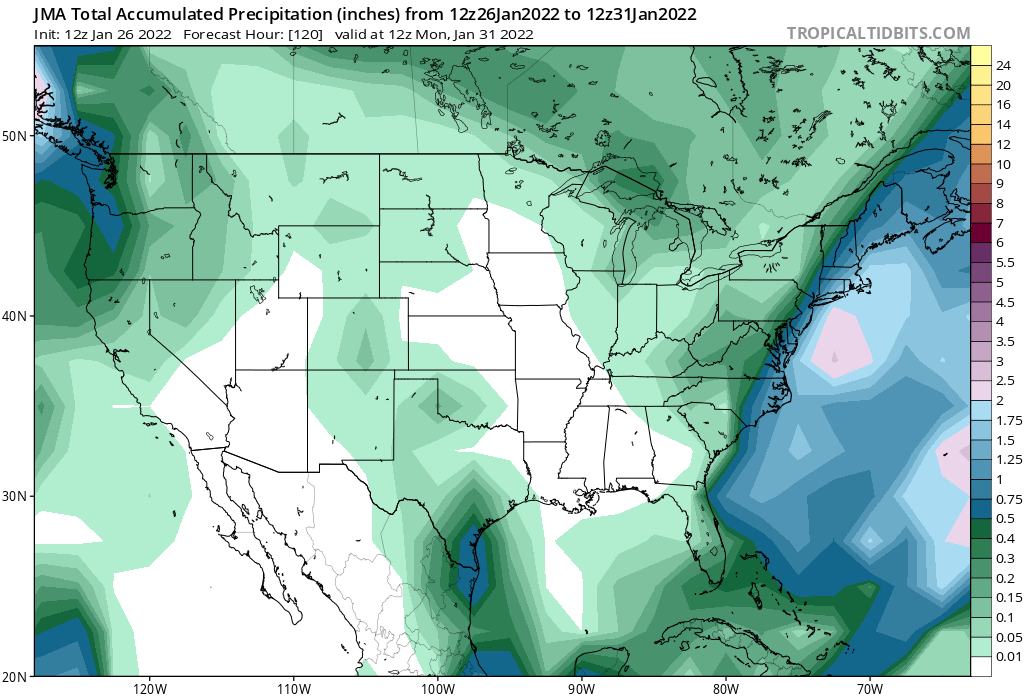
Euro vs everything else except maybe the JMA
JMA brought 1" of liquid to BDR. Would be a MECS/HECS.
-
 1
1
-
-
21 minutes ago, 78Blizzard said:
Time to retire the NAM.
The plan really is for NCEP to retire it and replace it with an FV3-based hi-res version of the GFS.
-
If Josh were admin he'd lock this thread.
-
1
-
 1
1
-
 3
3
-
-
1 minute ago, OceanStWx said:
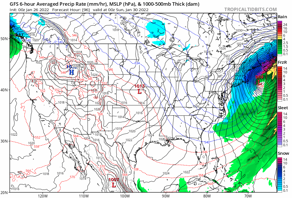
Good thing they are typically under-dispersive. Aside from the more hi-res stuff, all the models clearly ingested up on something today and moved as a result. Now recon starts tonight and satellite retrieval of the northern stream should be better by tomorrow, but if it's still meh at 12z I'm ready to just accept an advisory event to ruin a run at futility.
When they ingest satellite data, are they using more than just GOES-EAST and WEST?
-
3 minutes ago, Damage In Tolland said:
Huge bump NW 18z Reggie . Great trends this evening as the folks that called it over will start wondering why

Why tf are you using kuchera?
-
2
-
-
Just now, TauntonBlizzard2013 said:
I’m not sure I’d call a small improvement in the gefs that have looked atrocious for several runs a victory. I guess we are really stuffing that gunshot wound from 18z with as much quick clot gauze as possible
Unless of course all the NCEP models are wrong, which has happened before.
-
Does WPC still have a model diagnostic text discussion?
-
1 minute ago, mattm4242 said:
CBS and WCVB
I don't understand why they use such big snow maps.
Literally no one in CT receives WCVB or WBZ over the air.
-
Just now, Snowcrazed71 said:
This one's a goner guys. I don't want to say that because I really wanted this storm. I'm a full-out weather geek, weather weenie oh, whatever you want to call me I am. Even my spouse of my eight year old left how much I love the snow. But I'm giving up on this one. It's not coming back. I don't think anything's ever come back after where is gone to now.

-
2
-
-
-
Just now, EastonSN+ said:
More PV more problems
Careful not to add an "I" in between that.
-
-
Curious to see the 18z Euro.
18z CMC was slightly east.
-
-
8 minutes ago, snowgeek said:
A boat on the benchmark.
.I've been 75 miles off Chatham before in a fishing boat. It's amazing. With no land in sight the ocean swells look like hills and valleys.
-
1
-
-
9 minutes ago, 78Blizzard said:
Might be good to have some Crown handy if you're going to be on here tonight.
I have my Tito's available if need be.
-
Just now, JKEisMan said:
Did anyone post the srefs yet?
Man the modeling of this storm blows..
Dynamic synoptics will do that.
-
 1
1
-
-
It isn't closed off yet, so maybe it recurves slightly towards 70N?
-
1
-

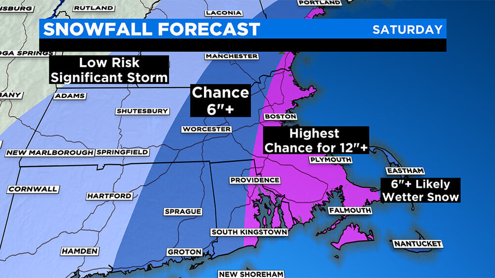
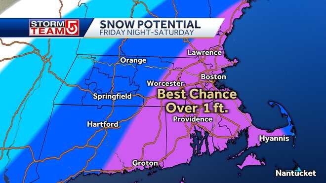
Powerful Multi-regional/ multi-faceted east coastal storm now above medium confidence: Jan 29 -30th, MA to NE, with snow and mix combining high wind, and tides. Unusual early confidence ...
in New England
Posted
Then you'll also be shocked to know the GFS has existed since 1980.