jwilson
-
Posts
1,290 -
Joined
-
Last visited
Content Type
Profiles
Blogs
Forums
American Weather
Media Demo
Store
Gallery
Everything posted by jwilson
-
Pittsburgh/Western PA WINTER ‘25/‘26
jwilson replied to Burghblizz's topic in Upstate New York/Pennsylvania
If you look at thermal profiles, you have the EURO/Canadian/NAM in one camp and the GFS in the other. The 6Z Euro was a slight step colder to a bunch of previous runs, as were the 12Z NAM and 12Z RGEM. Most of the models bring the 850s and surface temps above freezing up to Morgantown, while the GFS remains the most progressive with the transfer. Really, that transfer to the coastal low taking over as the primary is the key element regarding our thermal progression. If the primary low inland continues to dominate longer and maintains a northward push, that's how we get the warm tongue. The depth of the antecedent cold air should give us an advantage. The overall blocking is limited, though, which is why we're even talking about this. I guess you'd typically take a blend and cut the middle road, which should still keep PIT and most of the surrounding areas snow, but with the GFS kind of on an island, you'd take a bit less of it. I think Morgantown is a much trickier forecast. They could end up with 6" of pure snow and then a mix to rain. Either way, NWS will have to revise totals down for some of West Virginia, I think. GFS is the only model that keeps the state fully frozen. I don't think I'll be totally comfortable until we get most of the high-res models in range. It's a very delicate microclimate feature for our area. Those of you north of the city proper have nothing to worry about, though. The only other question is snowfall enhancement with the passing of the upper level trough after the main vort is through. Next weekend has potential, too, but it's a bridge too far right now. -
Pittsburgh/Western PA WINTER ‘25/‘26
jwilson replied to Burghblizz's topic in Upstate New York/Pennsylvania
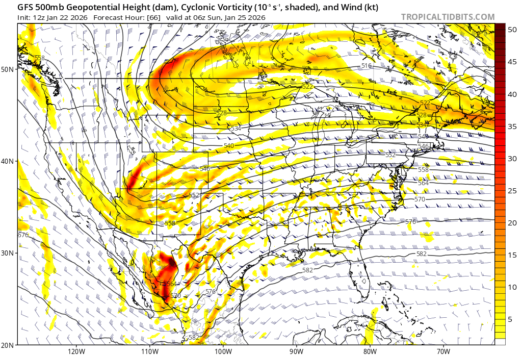
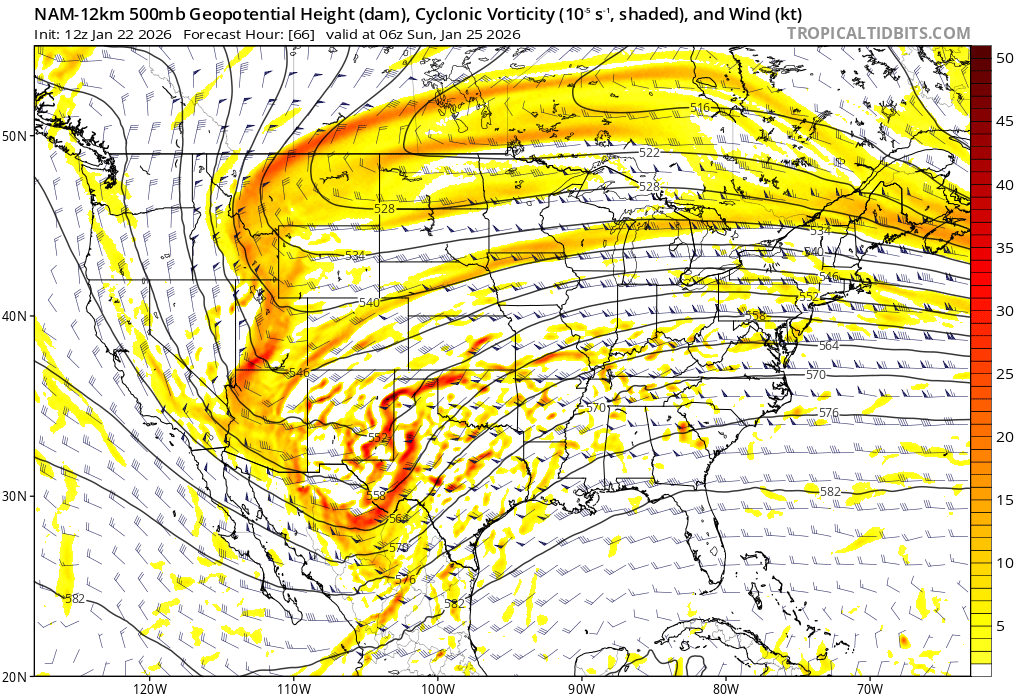
Sorry if I repeated you, I must have missed that comment somehow. 13 UTC NBM run did juice things up quite a bit. Mean is up to 12.5" now. Definitely a consistent trend the last couple days to keep increasing totals despite the one run from overnight (1 UTC) where things went back slightly. I'm kind of hoping that settles because eventually, as you see from some of the individual runs, we start inching into "mix" territory, and we know that warm tongue is often underestimated by the models. The chances of non-snow precip increased a lot (relative, 4% to 10%), as well. To see where things could go wrong, you might compare these two shots at 66 hours. Here we see the 12Z GFS with three distinct pieces of energy at 5H. Northern vort over Montana, secondary in Utah, and primary southern vort over Mexico. Hasn't quite phased yet. This is the 12Z NAM at the same time. We can see the distinct pieces of energy are interacting, instead. Southern energy is pulling north and west as a natural condition of the phase with the northern energies. We want the phase just not too early. The 12Z Euro hedges slightly in between these two, but as far as I can tell, neither the 700 nor 850 temps get above freezing as modeled there. Silver lining is the long-range NAM isn't all that good, but it is remains a possibility. Not quite in the "comfortable" range yet.

-
Pittsburgh/Western PA WINTER ‘25/‘26
jwilson replied to Burghblizz's topic in Upstate New York/Pennsylvania
The issue with Kuchera isn't necessarily the math but rather model output, so the maps themselves are often flawed. Ground truth is typically less, but that doesn't mean they are always wrong, of course. Snow calculation is complex, as is my explanation here (apologies). The actual equation for Kuchera is this: But nearly none of the output products in models take into account the other variables of snow growth. Lift, dendrite growth, and humidity, for example. Snowfall rates are never constant over X time. As a basic tenet, highest snowfall ratios (say 25:1) occur when most of the lift is situated at temps in the atmosphere between -12 and -18 Celcius. Otherwise known as the "snow production zone." There's a method (Cobb) that uses a layered approach to estimate snowfall ratios at a given time. It can be paired with Bufkit data to estimate total snowfall, because the Bufkit software has the highest vertical resolution to pair with soundings. Using this with the 6Z GFS run, for example, gives us 13.2" of snow on 1.04" of precip at AGC. Ratios vary from 5:1 up to 30:1 in hour snapshots. That's a higher-end result when compared with the averaged NBM data (0.79" precip average). Same method is 9.6" of snow on the 0Z GFS run. We can run this on the NAM, too, but it's not yet within range. My main point is that, looking at the 6Z Euro for instance, if people start expecting 17" they are quite likely to end up disappointed, so I had wanted to put out a general caveat emptor for those reading the maps that maybe aren't aware of the limitations. -
Pittsburgh/Western PA WINTER ‘25/‘26
jwilson replied to Burghblizz's topic in Upstate New York/Pennsylvania
NBM mean on today's 7 UTC run up to 11" even. Spread tightened a little more to 7" to 13" on average. 1 in 3 odds of >12" total. >8" up slightly to 68% chance. Most guidance held, so I guess we're waiting to see if a last minute de-amplification occurs. (As a side note, I see a lot of Kuchera maps, but just be careful about those as they tend to get overdone on totals.) -
Pittsburgh/Western PA WINTER ‘25/‘26
jwilson replied to Burghblizz's topic in Upstate New York/Pennsylvania
For what it's worth, 19 UTC NBM pretty much held serve from 13 UTC. Mean is 10.4", 73% chance of 6" or more, 63% chance of 8" or more, 36% chance of 12" or more. 4% chance of a historic level event (18"+). The spread has narrowed a bit, 6" to 13" (floor is up a couple inches). If the GFS leads us downward, that would be quite the bust considering all guidance right now, but I suppose it remains a possibility. Better plan for it. -
Pittsburgh/Western PA WINTER ‘25/‘26
jwilson replied to Burghblizz's topic in Upstate New York/Pennsylvania
Rare instance where the OP GFS will lead the ensembles, but the GFS has been all over the place so it's incredibly hard to trust no matter which way it goes. Frustrating model. -
Pittsburgh/Western PA WINTER ‘25/‘26
jwilson replied to Burghblizz's topic in Upstate New York/Pennsylvania
It would quite the coup if one guy went against every model, almost every other meteorologist in the East and got it right. If it's just an exaggeration, then okay, fair enough. I would guess over-amplification is more of a concern than suppression now, which Louis would seem to agree with, but we will know more tomorrow. Phased systems are always delicate, particularly when there is no block. -
Pittsburgh/Western PA WINTER ‘25/‘26
jwilson replied to Burghblizz's topic in Upstate New York/Pennsylvania
Perhaps I regret saying this, but I don't necessarily mind an overamped look with four days to go. A typical trend is to see these de-amplify as we get closer (say within 24-48 hours). The Canadian is especially guilty of overpowering primary low pressures. I'd give it another couple days before accepting that solution. It is running into a rather stout cold-air source. The NBM, meanwhile, continues to tick upwards on snowfall means. Last three runs have increased from 6.7" to 7.4" and then 10.2" on the 13 UTC run. Continues the trend from yesterday. Odds of more than 12" have gone up to 30%; 62% chance of 8" or more. That's increased from a mere 4% overnight for the former. If any de-amplification occurs, however, those odds will decrease. Mean spread is currently 4" to 13" plus maybe a little more on the backend. -
Pittsburgh/Western PA WINTER ‘25/‘26
jwilson replied to Burghblizz's topic in Upstate New York/Pennsylvania
I was reticent to share my thoughts on the upcoming system, because up until recently there had been a couple different "schools of thought," and even within those there are differential dynamics at play, like where the boundary sets, how cold is it, etc. It was also setting up outside of normal confidence windows (7-to-10 days). It all had to do with the ejection of the energy in the southwest. Some models would kick the energy out under the confluence and suppress it or shear it apart. Some models would hold and consolidate the energy to create something more akin to a SWFE (southwest flow event). We're seeing a lot more acceptance across multiple models now, however, so an event of some kind appears likely. I think the most relevant part to us is the level of phasing that occurs as that energy is stretched out from the southwestern CONUS. We see a relatively flat flow, overall, and the trough is never allowed to turn negative, which means we don't yet see a scenario where this turns and rides up the coast or is captured. The latter part is most relevant to the storm's overall potential and cap. Without a negatively-oriented trough, we aren't as likely to see "historic" numbers up along the Atlantic side. If you want an example of what I mean, look at the 06Z GFS at 300 hours (February 1st) and you'll see the type of negative turn coastal I describe. Simply described as "bombogenesis." We could still get a good haul from a long-duration overrunning event. That's what you're seeing in the southern US on the 06Z GFS, for example. Approaching two feet of snow in places like Chattanooga and Knoxville. Those numbers are unusual but not totally unprecedented. Chattanooga got 18" from the 1993 system, for example. Knoxville got 17.5" back in 1960. It is rare, to be sure, but it can happen, and the depth of the cold makes it a possibility. But the rarity should give you an indication of how likely model depictions are at this range. The biggest problem for us might be wave spacing combined with the confluence. You have a decent sized TPV lobe pushing down, but you also have another one or two discrete pieces of energy riding behind it. We're looking at a high of around 10 degrees on Saturday. That's colder than typically ideal when you're talking about big snows. There's also no real blocking in place. Some of the long-range looks appear to show a -NAO establishing itself. I think the main reason for this system, at all, is the sudden collapse of the AO (going deeply negative) and a transient PNA slide to neutral. If the MJO can continue propagating west, that might help keep our chances alive going forward. The AO is likely to rebound some but could stay well negative to displace the cold for us. As I'm typing this, we see how the 12Z GFS handles things quite different from 06Z. The 12Z keeps the energy separated and doesn't allow for any phasing to occur until the primary low is well out into the Atlantic. A lot of the energy from the 06Z that was stretched and created a SWFE was instead held back and closed off over Baja, Mexico on the 12Z. The 12Z Canadian is more like the 06Z GFS. The Canadian is a good middle ground, and while it is out of what we may consider an "ideal" position for us, ideal often means flirting with raindrops. Part of me thinks the even more interesting period to watch is after next weekend, but that much remains TBD. I'll probably dig into the maps a bit more later, hopefully after a few more model runs to see if any kind of consensus builds. There are a still a wide range of possibilities. -
Pittsburgh/Western PA WINTER ‘25/‘26
jwilson replied to Burghblizz's topic in Upstate New York/Pennsylvania
Pretty amazing run there from last night, but it's the GFS' unserious interpretation at 200+ hours. If you show that under 48 hours with support, I'll get interested. The long-term model depictions keep wanting to inflate the southern stream moisture involvement. Thus far through winter we haven't really seen that, so it's hard to trust. We'll have some rain transition to snow tonight with lingering bands, then another chance on Friday & Saturday for snow showers as an upper-level low passes overhead. -
Pittsburgh/Western PA WINTER ‘25/‘26
jwilson replied to Burghblizz's topic in Upstate New York/Pennsylvania
The potent combination of -AO/+PNA/-EPO is creating quite the cliff for cold air to jump off of and into the Eastern trough. Should have plenty of cold in the short-term (after tomorrow). Too much can wring out the moisture, of course, but the active northern stream Nina keeps energy moving. At minimum it offers mood flakes. -
I don't disagree, but at least publicly, realizing it's not necessarily honesty, players seem to like him. I don't think there's any way they can justify keeping him as OC. That bridge was burned this season. If he gets demoted back to passing game coordinator, it's a compromise. But the passing game has never been great during his tenure. That said, the offense was never built for prolific passing statistics, either, being run-first plus possession, so it's kind of a wash. Correlation vs. causation is hard to determine. Eagles definitely need to draft one, I agree. Calcaterra is a terrible blocker, so I don't love the idea of going into next season with him as #1, and I kind of don't like how the team keeps overusing him in running formations given how poorly he executes. For those reasons I'd prefer if the team moved on from him. If the coaches could use him more responsibly as a receiver, I wouldn't care. Dallas is also degrading as a blocker, so either way the Eagles need a true or more capable blocking TE.
-
Lurie is a measured guy. I think if they end up firing KP, it will take some time to do exit interviews and all that, including perhaps assessing player attitudes. It might also require assessing Sirianni, himself. I don't think he should or will be fired, but this might be another test of submission. There's also a chance KP sticks around to appease Sirianni but gets a demotion. I don't know if this is exactly the same situation as what happened to Doug. My instinct was that it feels the same, and if Sirianni is going to fall on the loyalty sword, the Eagles would can him, too, but maybe they won't be as hasty to relive that same scenario. There were lots of problems with player execution this year, and perhaps the front office thinks the regression from the offensive line was more problematic than the overall scheme. Maybe they think KP can improve with more guidance. I wouldn't necessarily agree with either of those opinions, but they do have more information about what goes on behind the scenes. Either way there will be changes of some kind. The offense is too expensive to be this bad. I know the lack of running Jalen is to help preserve his health, but I question whether trying to turn him into a pure pocket passer when the run game is flailing will work. However, given how deficient the passing scheme is, it's hard to tell what is more problematic. I'm kind of on the "trade Brown" train because I think he's a declining player moreso than any other reason, but his contract may force the Eagles to keep him around at least one more season. Maybe a new OC helps him, too. They don't yet have a receiver to replace him, either, and will possibly lose their best TE also without a ready replacement. Maybe Dallas signs another one-year deal. He probably wants more security, at this point.
-
Pittsburgh/Western PA WINTER ‘25/‘26
jwilson replied to Burghblizz's topic in Upstate New York/Pennsylvania
Difficult to buy into anything right now. Mid-range modeling has been suspect for a few months. Long-range is worth even less. I'm not too worried about individual threats until they close within three-to-five days. The best we might hope for is a return to the December clipper-heavy pattern. I think it is possible, if not probable, that the worst of our winter cold is over with, however. Height anomalies over Canada don't look quite as robustly cold as they were a month ago, and a massive building -EPO coupled with +PNA might reconfigure how cold air gets moved through the CONUS. A huge ridge out west precludes cold air from coming at us in a westerly fashion and retains a more northern component. The ridge does create opportunities for storms to ride down the spine and amplify south of us, but the speed of the northern stream combined with a lack of blocking really caps any potential. Even a big coastal would move in a hurry absent additional variables that aren't yet clear. The combination is a somewhat typical Nina atmosphere. Not to say the rest of winter will be warm, only that it is more moderate than what we dealt with previously with quite negative departures. A February warm-up is always a threat. If you do believe anything very long-range, the data itself doesn't yet support that outcome. Cold conditions may be bolstered if the MJO eventually traverses through Phase 7 as currently progged. -
Boxing Night Snow/Sleet/Ice Dec 26-27 Storm Thread/Obs.
jwilson replied to Mikeymac5306's topic in Philadelphia Region
NBM whisker is between almost 0" and 5" so there remains a wide spread of formulations across models. Clearly going to be a meso-defined event so we probably need to get a little closer to onset. 25% chance of 6" or more at KPHL. Not great odds but there's still a clear potential. 4" to 6" seems like a fairly aggressive early call, though, in my non-professional opinion. I'd like to hear an expert opinion on that given the spread. -
E PA/NJ/DE Winter 2025-26 Obs/Discussion
jwilson replied to LVblizzard's topic in Philadelphia Region
13 UTC NBM still favors odds of rain-to-snow 55:20 at maximum rain potentiality, but it closed the gap a decent amount from a peak of 66:4 at 7 UTC. In other words, there was a clear cold trend. It also now favors snow early on the day Friday, 34:28, as opposed to the 66:13 rain-favored odds from the run before. A mix is a good call right now unless the trend continues. -
E PA/NJ/DE Winter 2025-26 Obs/Discussion
jwilson replied to LVblizzard's topic in Philadelphia Region
Most typical arrangement of indices and ingredients for a major coastal are -NAO, -AO, +PNA, -EPO, and a 50/50 low that locks forward movement of the main cyclone. 50/50 is latitude and longitude. You want the +PNA because it orients the ridge axis out west that, in turn, creates ideal trough orientation downstream / in the eastern CONUS. Storms can ride the trough, gather strength, and come north. There's some more nuanced version of the variables that might be even better, that is, a pattern that's relaxing (like a -PNA going positive or a -NAO going positive) lending to higher correlation. -
Pittsburgh/Western PA WINTER ‘25/‘26
jwilson replied to Burghblizz's topic in Upstate New York/Pennsylvania
Long-term, the warmth has muted somewhat, but the pattern remains pretty hostile. Still seeing shots of cold with brief hints of 50s preceding them. More "seasonal" temps, overall. Seems the -PNA is locking in for the foreseeable. The other indices might head in the right direction, but until we fix the pacific side, the true snow events and sustained winter might be harder to find. For a muted Nina that seems about right. We don't want to see what the long-range EPS and GEPS show, however. Full latitude ridging and the cold air is scoured out of nearby Canada, but the long-range warm looks have been difficult to trust. Seems the models want to revert to a more typical Nina base state (of moderate variety or stronger). Maybe come January we can re-establish a more favorable pattern. -
Pittsburgh/Western PA WINTER ‘25/‘26
jwilson replied to Burghblizz's topic in Upstate New York/Pennsylvania
I saw an 8.8" measurement in NWS PIS (before lake effect), seemed kind of high to me. The wind and drifting made things difficult to measure. I had about 5" at midnight on Saturday based on some manner of averaging and trying to find a decent wind-protected spot. We probably got another 1.5" afterward. There were some decent rates, at times, but nothing like that 2020 event with 4"/hr. -
Pittsburgh/Western PA WINTER ‘25/‘26
jwilson replied to Burghblizz's topic in Upstate New York/Pennsylvania
I think the NWS tends to lean NBM - latest run has Morgantown with a 44% chance of 8" or more. 76% chance of 6" or more. Pretty decent odds. I'm sure the typical places with orographic lift will jackpot. AGC has a 46% chance of 6" or more for the same run. Almost a coin flip. Blend mean is 4.1" total but it seems to favor an amount between 4-7" for AGC. That's definitely bullish, as even the unreliable but typically juiced SREF mean is lower, but I'm not sure what ratio that plot measures. -
Pittsburgh/Western PA WINTER ‘25/‘26
jwilson replied to Burghblizz's topic in Upstate New York/Pennsylvania
Definitely going to come down to where the relatively narrow band of frontogenesis sets up. It's going to be cold-cold, so the ratios should be quite decent with any kind of moderate snow growth under convergence. It's only about two to three tenths of precip total for AGH. Have to make it count because it could be the last look at snow until towards New Year's or into 2026. Christmas Week is looking too warm. -
Pittsburgh/Western PA WINTER ‘25/‘26
jwilson replied to Burghblizz's topic in Upstate New York/Pennsylvania
Some flizzard yesterday, but now it's looking like the next discrete event is Saturday into Sunday. Evolution looks pretty similar to the one on the 2nd. Another quick hitting 2-4" event. Initially, it looks a little colder than the last system, so perhaps there's less concern for mixing in the southern areas. Fairly decent agreement amongst the major models for a synoptic event at this range, though. The smaller details will have to get worked out later. -
Pittsburgh/Western PA WINTER ‘25/‘26
jwilson replied to Burghblizz's topic in Upstate New York/Pennsylvania
I'll take the 4" and run on December 2nd. That's better than many of the recent Decembers put together. -
Pittsburgh/Western PA WINTER ‘25/‘26
jwilson replied to Burghblizz's topic in Upstate New York/Pennsylvania
Tomorrow looks like a classic southern slider with just enough northern stream interaction to get us 2-3" and keep the rain at bay, except for those in the southernmost counties, of course. The warm tongue is undefeated. Not likely to find any big events in this pattern, but the next couple weeks look okay for those old-timey Alberta Clippers. I'm sure we'll take any snow while we can get it. It should make things look festive around these parts until the (perhaps brief) Christmas warmup. -
Pittsburgh PA Fall 2025 Thread
jwilson replied to TheClimateChanger's topic in Upstate New York/Pennsylvania
With the first snow around - somewhere - I guess it ignites the mood. *Cue eggplant emoji* We do still have a few more weeks of meteorological fall. For now, it seems most, if not all, of the models want to build a -NAO block towards the end of the month. First step is seeing if that verifies. Next step would be determining if it's relevant this early in the year and how long it could last.