
.png.077deb4d0b08726b9bd916fd6b3e3ccb.png)
Weather Mike
-
Posts
151 -
Joined
-
Last visited
Content Type
Profiles
Blogs
Forums
American Weather
Media Demo
Store
Gallery
Posts posted by Weather Mike
-
-
2 minutes ago, StantonParkHoya said:
Ensembles, not operationals
you are correct
thanks
-
 1
1
-
-
3 minutes ago, bdgwx said:
A blend of the 12Z cycle GFS, ECMWF, and UKMET ensembles are showing a landfall south of Tallahasse, FL between hour 120 and 144. It looks like this is a tick west of the 2pm EDT NHC official track.

not sure how that can be that west when Euro and UKMET are east and the GFS shifted east just now towards Tally so not sure I am buying too much into that based on the 12Z Euro and UKMET
-
51 minutes ago, Hotair said:
Crap! Euro really wants to end Tampa’s streak of cane free seasons.
my South Tampa home will be under water if Ian does anything remotely like this model insists on.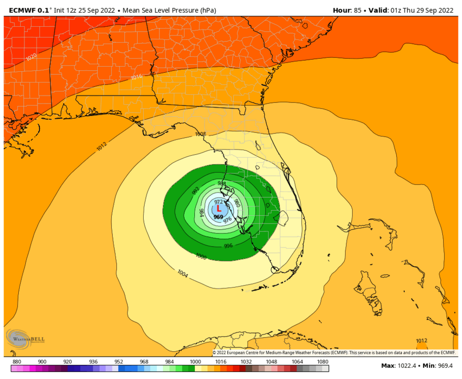
Yea my home in Sunset Park will have fish swimming down the street
-
56 minutes ago, MANDA said:
Not wavering at all. Be wary on intensity though. Intensity still holy grail of hurricane forecasting. Conditions on that track would be favorable for something stronger. Not saying EURO is wrong but there is upside potential on a track coming in around or south of Tampa.
Fact that EURO is not wavering for several runs now has to lead to higher confidence for landfall west coast of FL vs. Panhandle.
Intensity is bigger question in my mind on a track like EURO is showing.
12Z JMA looks very similar to 12Z Euro
-
10 minutes ago, AChilders said:
Euro not wavering any

Euro has been consistent over past several runs. Not taking the bait to go west like the GFS
-
4 minutes ago, nrgjeff said:
Clearwater and St. Pete at least looks in the right side passing, if not worse. @Dbullsfan22 I'm already looking for non-met friends down there; otherwise, the Board normally does not do that type of forecast.
Jim Cantore in Clearwater today and never a good sign to see Jim in your neighborhood
-
 1
1
-
 1
1
-
-
12 minutes ago, MANDA said:
Was anticipating a much more organized looking system this morning. Surprised by lack of organized convection. First visible pictures of the day does show well established outflow in all but western sector. Shear is light and water is warm. Just need to get the LLC more vertically stacked with mid levels and then things should start to quickly improve. Should happen by evening but yesterday I thought that process would be completed by this morning so we'll see. Still interesting questions on landfall (GFS/EURO) and intensity at landfall. Some rapid model weakening going on late in the forecast period. Interesting overall situation to watch unfold. Landfall on the FL west coast would of course be the worst case in terms of intensity at landfall, especially if it landfalls from about Tampa southward. Panhandle to Big Bend likely weaker landfall solutions come into play. No real cut answers this morning. Still leaning 50-100 miles either side of Tampa for a landfall. Interesting to watch it unfold.
Euro, ICON and UKMET has been steadfast against the GFS and all the others that head it up the panhandle. Will be interesting to see what unfolds.
-
7 minutes ago, StantonParkHoya said:
notable that only one GEFS member goes south of Tampa with a very large contingent into AL or even LA/MS
Curious if most of the models that take it into the panhandle are basing the low further south? Or maybe there is more to it then that ?
I don’t want it in Tampa trust me but I’m not closing the door on the possibility these models swing the other way over the next day or two to correct themselves once a low has been established and that trough has been better sampled. -
15 minutes ago, Hotair said:
Recon is finding lows at both 13N and 14.5N. Convection is north of that. At some point in the next 24 hours one of those should dominate. If the southern one wins out then we are looking at potentially a weaker storm on a more westerly track into the Golf. If the more northern low wins it means the storm can get more robust and have an easterly bend bringing it well into the Florida west coast.
these two scenarios kind of reflect the GFS vs Euro solutions playing out
Hopefully tomorrow we can finally establish a low and the models and come to a better agreement. I am sure like you said they are handling the lows differently and possibly the interaction with that trough.
-
 1
1
-
-
2 minutes ago, Prospero said:
Well, I am ready to feel like a ping pong ball for the next few days. The GFS is better than what the NHC says.

For the sake of you and I I just hope it does not turn out to be a landfall between the GFS and Euro run as we will not be in a good position with some bad storm surge.
-
1
-
-
4 minutes ago, StantonParkHoya said:
If by just west, you mean 150 miles west. It’s noticeably west of 12z.
yes its more west then 12z. I was not making a refence as it was just off the coast. But more so its position being west of Tampa.
Looks like a Tallahassee special
-
2 minutes ago, CamSE-Wx said:
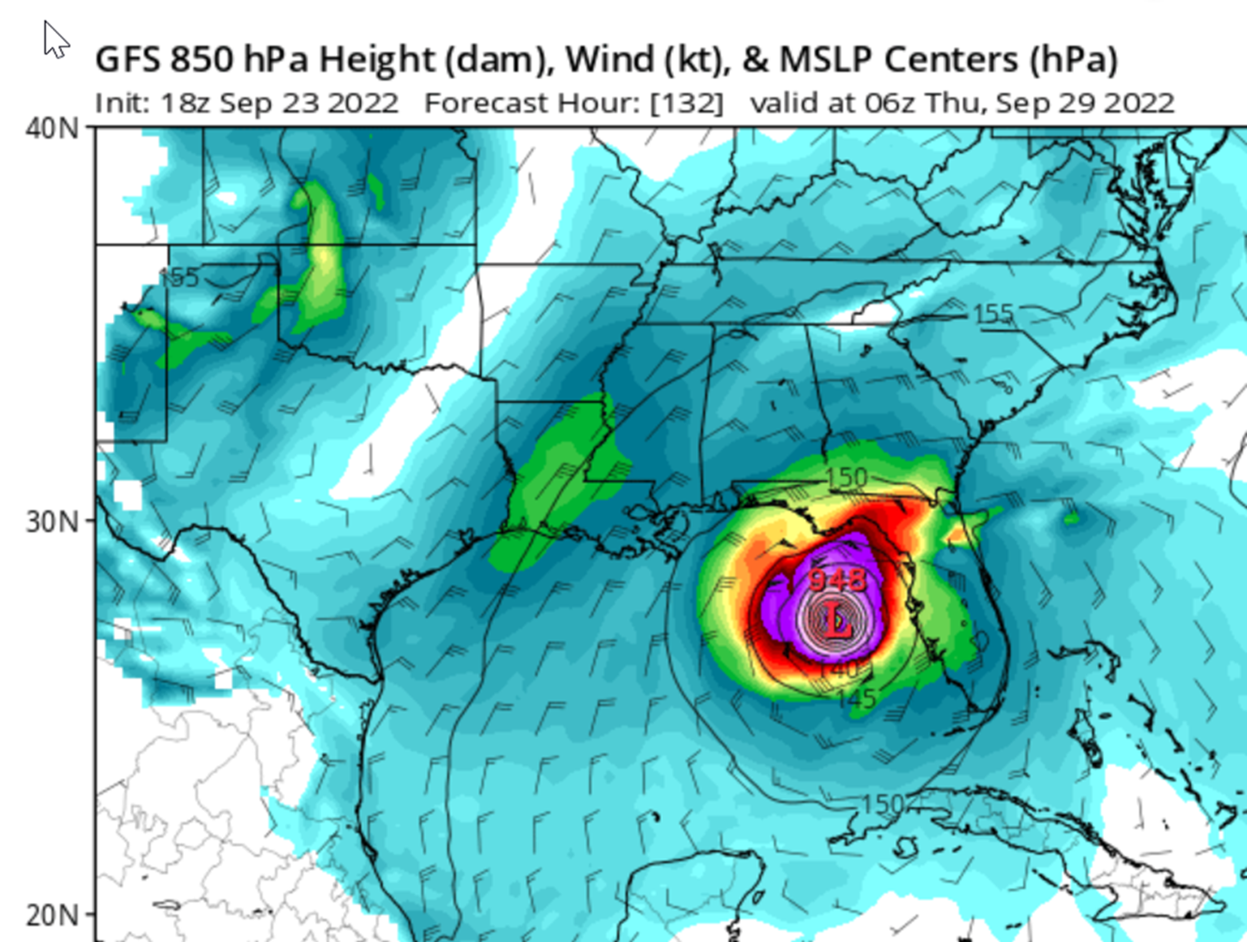
18z GFS coming in stronger and southwest through 114. Down to 932 from from 953 on the 12z
starting to weaken slightly as it heads due north just west of Tampa
-
36 minutes ago, Prospero said:
In the Tampa Bay area, we have become a little too casual. But when you spend time and money to batten down the hatches over and over every year to be spared totally by yet another scary storm and still have some more work to do to unbatten everything after it passes, we get careless. And that is after having to put out a lot of money for repairs and cleanup after a storm does come too close feeling grateful we did whatever we did to batten down the hatches. Maybe 5 years is the threshold where we get lazy.
If NHC is even as good as 2021 I am concerned a little.
What caused Charlie to change paths and head in earlier ? Is the environment around for a similar possibility with this TD as it head up the west coast of FL as a Hurricane ?
-
1
-
-
20 minutes ago, WinterWolf said:
Everything is in play at this juncture…lots of moving parts that aren’t being sampled correctly yet.
Like to see those extra weather balloons looking at those upper level winds regarding that trough
-
1
-
-
1 minute ago, GaWx said:
12Z UKMET a big shift back to the SW vs the 0Z run with it nearly stalling at the 85W longitude 200 miles west of Naples:
TROPICAL DEPRESSION 09L ANALYSED POSITION : 14.4N 69.4W
ATCF IDENTIFIER : AL092022
LEAD CENTRAL MAXIMUM WIND
VERIFYING TIME TIME POSITION PRESSURE (MB) SPEED (KNOTS)
-------------- ---- -------- ------------- -------------
1200UTC 23.09.2022 0 14.4N 69.4W 1009 24
0000UTC 24.09.2022 12 15.1N 71.6W 1008 26
1200UTC 24.09.2022 24 15.0N 74.1W 1007 29
0000UTC 25.09.2022 36 15.0N 76.2W 1005 28
1200UTC 25.09.2022 48 15.8N 78.5W 1004 31
0000UTC 26.09.2022 60 17.3N 80.4W 1002 33
1200UTC 26.09.2022 72 19.1N 82.1W 1000 34
0000UTC 27.09.2022 84 21.2N 82.8W 998 40
1200UTC 27.09.2022 96 23.4N 84.1W 997 38
0000UTC 28.09.2022 108 24.5N 85.0W 995 42
1200UTC 28.09.2022 120 25.2N 85.1W 996 44
0000UTC 29.09.2022 132 25.9N 84.9W 996 48
1200UTC 29.09.2022 144 26.1N 84.8W 996 50I assume the UKMET and GFS are representing different interactions with the trough vs the Euro and ICON for example ?
-
41 minutes ago, jrips27 said:
NHC now explicitly forecasting a major at landfall
Thats a lot of surge coming into Fort Myers and Port Charlotte.
-
30 minutes ago, cptcatz said:
06z GFS with worst case scenario for Tampa. Good thing that won't happen since based on what I read here Tampa can't get hit?
Yes that's terrible for Tampa.
Tampa to Naples is my landing zone probability. Hoping for a change because that 06z GFS is terrible for me and others around the greater tampa bay area.
-
10 minutes ago, MJO812 said:
Big shift east with the gefs

Change from yesterday as now most major models are targeting Florida from the big bend to the Keys. See if this continues tomorrow and beyond.
-
1
-
-
16 minutes ago, Eskimo Joe said:
FYI, NHC mentioned last night that recon data on 98L is getting ingested into NWP now.
12Z CMC and ICON look very similar
-
16 minutes ago, GaWx said:
Here's how I see it. Late Sept climo does not favor the good number of EPS members going NE across the S half of FL. That's more like mid Oct and later climo. But there's an Octoberlike upper trough coming into the E US days 4-6 before lifting out. Notice that the faster EPS members are mainly the ones that turn NE across S FL. So, it appears that a big key will be speed of 98L. If it goes faster, it will have a better chance to get caught by the upper trough and move NE over the S half of FL. But, if not fast enough, it very likely won't and would instead likely hit the N Gulf coast anywhere from the FL Big Bend westward to LA and probably at a slower speed.
great point !
-
1
-
-
49 minutes ago, Intensewind002 said:
Hurricane Lili might be a decent analog for this storm

Possible but Euro still says no I am coming on shore just north of Tampa.
Will have to see what unfolds
-
1
-
-
3 minutes ago, SnowenOutThere said:
CMC with a New Orleans impact

So far looking like New Orleans far west to as far east and south as Port Charlotte area. Still long way away. Will it miss that trough or not ?
-
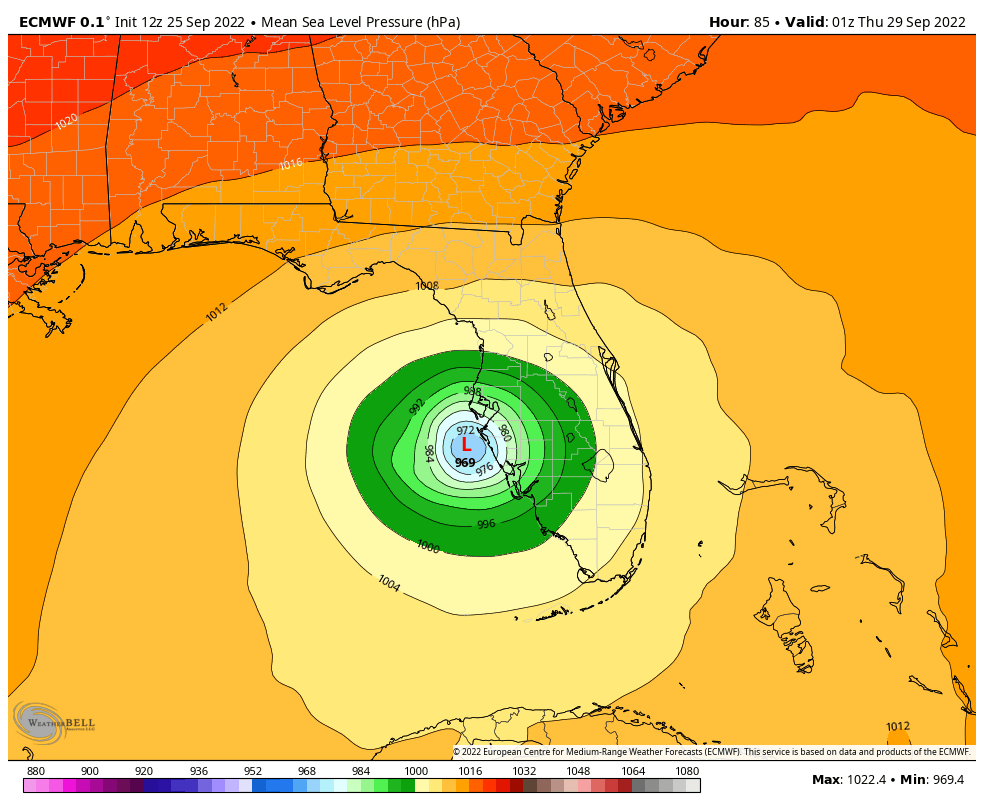
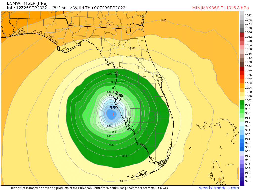
4 hours ago, Normandy said:
The Euro shows the potential for an S FL / East Coast Strike. The bend north after the recurve is a bit unsettling....
any model pics of that ?
-
14 minutes ago, Normandy said:
With the size of the system that is the worst case scenario for Tampa. The eyewall would be just offshore, but the surge would still pound the bay. Also these recurving systems tend to slide east (at least from what ive seen tracking the last 20 years).
Yea I dont like that run. Too close for comfort.

Hurricane Ian
in Tropical Headquarters
Posted
Euro had it strengthening later vs GFS