
.png.077deb4d0b08726b9bd916fd6b3e3ccb.png)
Weather Mike
-
Posts
151 -
Joined
-
Last visited
Content Type
Profiles
Blogs
Forums
American Weather
Media Demo
Store
Gallery
Posts posted by Weather Mike
-
-
1 minute ago, sbnwx85 said:
Lots of moisture out there already.

GOM is open for business
-
 1
1
-
-
2 minutes ago, SchaumburgStormer said:
HRRR is banging the north drum hard.

love that. Bang that north drum
-
7 minutes ago, mimillman said:
Spread on plumes at ORD is pretty solid 10-15”
Wonderful to see that. On the plane now heading to Chicago. Those other members waiting to buy their tickets to come up north to get on this action, lets go. I feel better today for Chicago then I did yesterday.
-
4 minutes ago, Owensnow said:
God I hope the RAP is on to something. Everything else is SE now
GEM also appeared to stay inline with the RAP
-
5 minutes ago, Owensnow said:
yuck

not good for chicago so we must throw that run out
-
1
-
-
Just now, Baum said:
eh the model burnout is real. It'll be nice just to nowcast soon.
agree. one goes a tick north and another a tick south etc. We are talking about small changes now. The main track is set. But its those norther fringe people that are most concerned with those small changes
-
1
-
-
7 minutes ago, mimillman said:
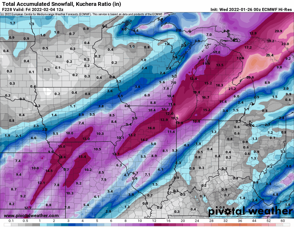
12.5” SREF mean for ORD. 8-12” cluster and a 15-17” cluster. Has that 8-12” look
thats great for Chicago metro. 6z HRRR was a great run as was the GEM. Nice also getting more love from the Euro this AM. Flying in today so looking forward to some great weather to enjoy while on business there. Will have to stroll lakeshore drive to take it all in. Still nervous as that northern fringe is close to I-88 region. Need that to hold back.
-
1
-
-
1 minute ago, ILSNOW said:
the way this is going the wednesday forecast for Chicago will Partly sunny, with a high near 30.
Well yesterday was more north trend and today is more south so we still have tomorrow for it to come back north so we don’t have to enjoy partly cloudy conditions in Chicago on Wednesday. However not looking good at the moment.
-
1
-
-
1 minute ago, Powerball said:
Now watch the EURO come in super amped.

Agree GFS making some slight corrections south. Euro coming slightly north. ICON south. RGEM and NAM coming north.
What a battle. Some changes of 30-50 miles makes a difference.
-
1
-
-
14 minutes ago, ILSNOW said:
yep the folks in Central IL are due and as currently modeled they get buried into Northern IN.

Gary to Chicago is only 30 miles. Enough room at this time to bump north for larger totals in Chicago if the NAM were to verify.
-
2 minutes ago, Powerball said:
Still, it is unfortunate that we got several runs (that seemed to be consistent at first) with those insane amounts setting up further NW.
Now some people will be disappointed over getting what will still be a big snwostorm (just not epic/historic).
Still too early in my opinion to say someone right outside maybe 100 miles cant cash in. GFS was terrible for that Boston blizzard 2 days before so this can still jog north or south some based on more sampling etc so these later runs and into Wed AM will be interesting. Plus for Chi metro lake enhancement will also be an unknown variable.
-
2
-
-
2 minutes ago, Chicago Storm said:
18z GFS is coming north with everything... Overrunning event and the main storm system.
Here she comes ! The north trend is continuing
-
2 minutes ago, Baum said:
for Northeast IL folks. All caveats aside that it's NAM 84 out, and I'm a novice when it comes to model interpretation but liked the look of it as it seemed to bring the overunning back north into a good part of the metro as opposed to 12Z which kept it all south. Also, looked like 2nd wave was poised to do some damage as well.
I see that also.
I fly into Chicago tuesday night for business so would love to catch a good snowstorm while I’m there.
-
1
-
-
Euro has appeared to blink at least based on that 12z
Looks similar to 12Z NAM
-
Ensemble mean from euro. Much different from op. Something dont seem right.
Hard to not lean towards the Ensembles as they have been steadfast vs op runs for some of these model runs such as this recent Euro
-
Just now, Sciascia said:
As location continues to wobble, these models just continue showing monster totals run after run. That’s the best sign of anything.
Agree as others have said we should all be thrilled with the large numbers in precip as that seems for sure now it’s just a matter of where this ends up after all the wobbling.
-
3 minutes ago, KokomoWX said:
The Euro has trended nicely for IMBY.
I like Chi metro position as others have mentioned. Plus this will wobble back north and south some so let’s see where this eventually ends up.
-
2 hours ago, Baum said:
on the back burner it appears until The Great Chicago Lake Effect Event 2022 clears out.
agree this thread will become more active after that lake event and hopefully we can continue to see those numbers the GFS had yesterady.
-
55 minutes ago, RCNYILWX said:
With a super busy shift at LOT today dealing with LES threat, tried to do most I could to add some general details in extended. Asked neighboring offices if they'd consider tossing in some sleet and freezing rain chances and they opted against it, so I blanketed CWA with sleet/freezing rain chance late Tuesday night through Wednesday night.
In reality obviously not the whole area would be in threat zone for icing on top of sig snow threat, but the surface and lower level pattern strongly supportive of a zone of sleet and freezing rain with cold drain from 1045 mb high to north. Hopefully most of the CWA ends up mostly snow and we get a big event (or an appetizer round) followed by the main course.
Sent from my SM-G998U using Tapatalk
Thanks for the insight. I will be flying into Chicago Wed afternoon so will be watching this system and Mets like you closely.
-
1
-
-
ICON has loved Chi town over and over these past couple of runs
-
2
-
-
Just now, Powerball said:
It's going to be a New Years to remember if the 12z GEM is right.
Severe weather outbreak in MO/OK and Blizzard in MN/WI.
Love it. Lets keep this trend going
-
1
-
-
7 hours ago, WI_SNOWSTORM said:
lol

that would be epic.
I am heading to the Green Bay game on the 2nd so please yes let that verify
-
 2
2
-
-
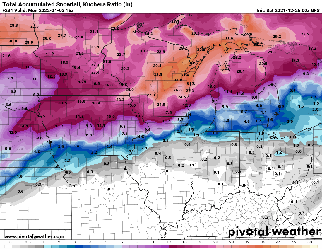
1 hour ago, DaveNay said:
I'd say that has about the same odds as Nagy keeping his job.
Any maps or ideas on the system that appears on the GFS and Euro around Jan 1-2nd? Looks good on some runs not all. Something to watch at least.
-
5 minutes ago, rochesterdave said:
Let the crazy commence

Love it for my Lake Placid region. GFS appears to also be in agreement. Seems like the track is pretty much set plus or minus some wiggle room N or S. This should have already been sampled by now.
-
4
-


Feb 1-3rd GHD III Part 3
in Lakes/Ohio Valley
Posted
snowing a lot in chi metro now