donyewest
-
Posts
137 -
Joined
-
Last visited
Content Type
Profiles
Blogs
Forums
American Weather
Media Demo
Store
Gallery
Everything posted by donyewest
-
Western PA/Pittsburgh Fall Weather Discussion
donyewest replied to Ahoff's topic in Upstate New York/Pennsylvania
Tornado warning was just to my south, right on the polygon, finally got emergency weather alerts on my phone at least. -
Western PA/Pittsburgh Fall Weather Discussion
donyewest replied to Ahoff's topic in Upstate New York/Pennsylvania
This atmosphere is primed for some severe weather. The wind would definitely up the tornado chances. Already secured loose stuff outside. Butler is in the bullseye for 3hr calibrated severe thunderstorm guidance for the SPC. -
@WxUSAF Don't worry but work quickly: I got water, 0.25~0.50", across half my finished basement last week from a thunderstorm dumping 2.5-3" in ~2hrs via a basement window well. I freaked out and worked through the night to get the water up, started a dehumidifier, and then grabbed 2 smaller ones on sale. Been running them all and RH is 35%; the water didn't even reach the drywall, it was absorbed by the 2x4 frames. As long as it isn't reoccurring or consistently moist down there then you should be fine (3x coats of moisture barrier on the walls here in soggy wstrn PA). Also bought an automatic pump from Harbor Freight should anything close to that try to happen again.
-
Western PA/Pittsburgh Summer Discussion 2021
donyewest replied to Ahoff's topic in Upstate New York/Pennsylvania
Keep this stuff south, please. Butler has seen enough rain, the patio has been wet for a week now. -
Western PA/Pittsburgh Summer Discussion 2021
donyewest replied to Ahoff's topic in Upstate New York/Pennsylvania
Yep, I was in one of the areas that received 2.5-3" of rain. Torrent of water shot straight from the wooded area above on a direct path to my basement window well, didn't realize until it was already full of water, got about 0.5" across half the basement floor through the window. Redirected the water up on the slope and bucketed out the window well as if I were on a sinking ship. Nothing really damaged as I was able to vacuum the water up and got dehumidifiers, fans down to the basement super quick. The creek further down the slope swelled to a size that one of the elderly neighbors said, "I've lived here my whole life and only saw this happen 2 or 3 times." He said the last time it happened was when there were two hurricanes that came through back-to-back. Road was closed where the swollen creek passed under it and a few miles down from there are, well *were*, train tracks now washed out. -
Western PA/Pittsburgh Summer Discussion 2021
donyewest replied to Ahoff's topic in Upstate New York/Pennsylvania
85F with 79F dew point at Butler FW7554 = 98F heat index, yuck. All the house windows are fogged over. -
Western PA/Pittsburgh Summer Discussion 2021
donyewest replied to Ahoff's topic in Upstate New York/Pennsylvania
And lots of ground moisture for the sun to crank up the dew point too if it so much as even peaks around a cloud. Totally awesome weather to work in while I clear a huge oak that fell in the backyard starting tonight, unfortunately. -
Western PA/Pittsburgh Summer Discussion 2021
donyewest replied to Ahoff's topic in Upstate New York/Pennsylvania
Higher lows likely because of the increased moisture means air temp can only go as low as the dew point. Higher dew points mean we can't cool our bodies very well which is a real burden for those without AC/cooling to bear The NW is getting the heat because the high pressure is north of them, they are in quadrants 3/4 if you bisected the high, and the clockwise flow means adiabatic heating as the pressure pushes and compresses the sinking air coming from higher elevations, heating it in the process. The Bermuda high and SE ridge clockwise flow put us in quadrant II, sometimes I, so our air is mostly humid heat that pools against the slopes of the Appalachian ridges. If there were a high pressure north of us in Canada, we might be in a position to see some high temps. -
Western PA/Pittsburgh Summer Discussion 2021
donyewest replied to Ahoff's topic in Upstate New York/Pennsylvania
Did some lawn stuff and put grass seed down early this morning hoping for a good rain up here little north of Butler and the driveway barely ended up wet. Everything went north and south of us. -
Western PA/Pittsburgh Spring Discussion 2021
donyewest replied to Ahoff's topic in Upstate New York/Pennsylvania
CPC has us in slight hazard for excessive heat next week, KPIT NWS discussion mentioning lots of heat and humidity coming our way too. NWS Blend of Models has trended up for Sunday 18z temps on nearly every run since Mon 12z: 82F to 86F. -
Western PA/Pittsburgh Spring Discussion 2021
donyewest replied to Ahoff's topic in Upstate New York/Pennsylvania
I hope! Bet we pull the regular hot and humid all day, frontal passage as the sun sets, little widespread rain relief, temps/dew points go down slowly. The ol' okie-doke. -
Western PA/Pittsburgh Spring Discussion 2021
donyewest replied to Ahoff's topic in Upstate New York/Pennsylvania
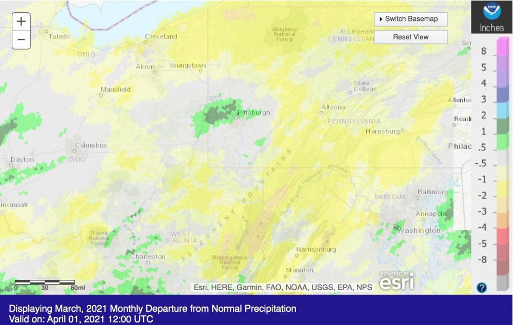
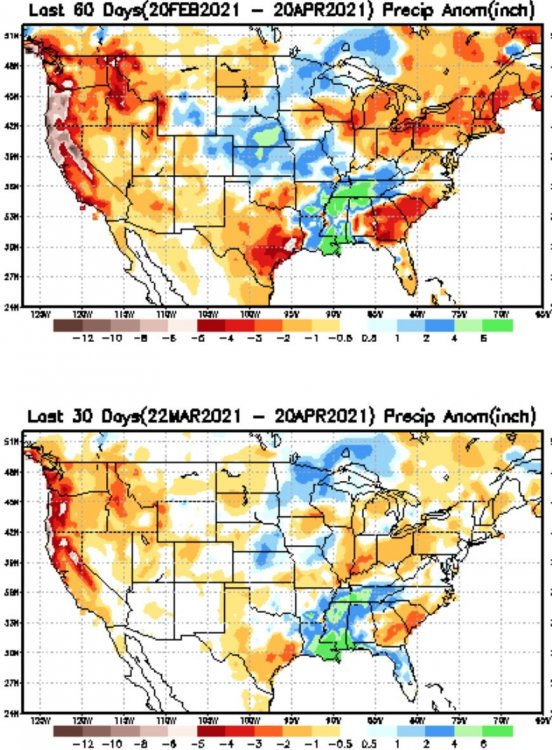
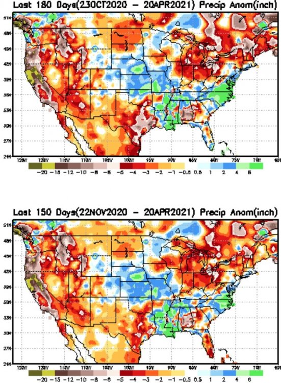
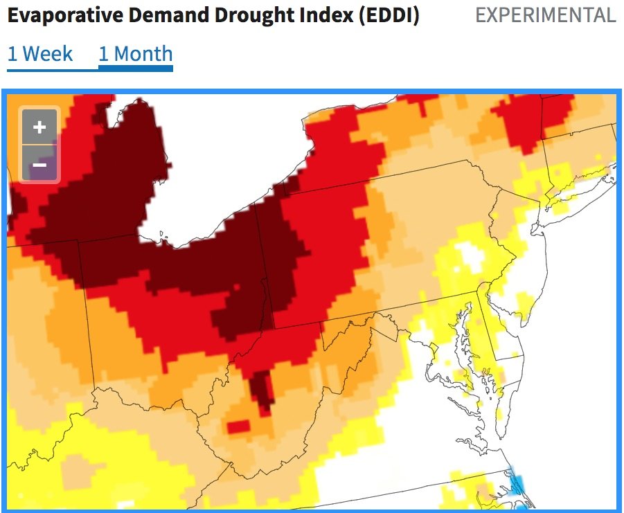
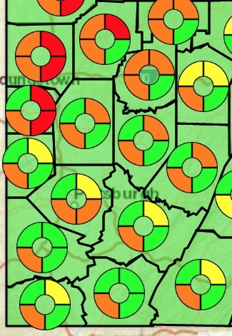
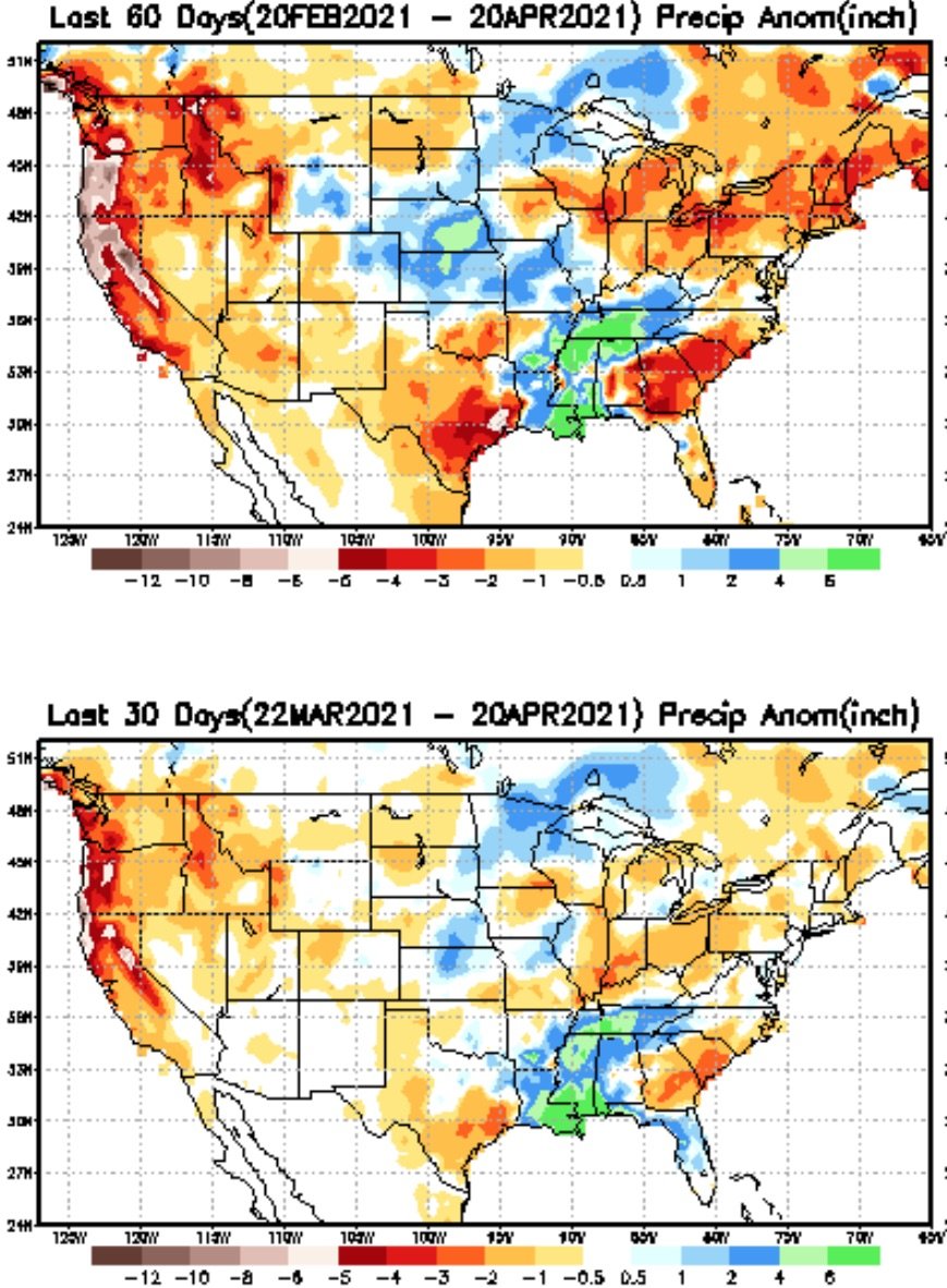
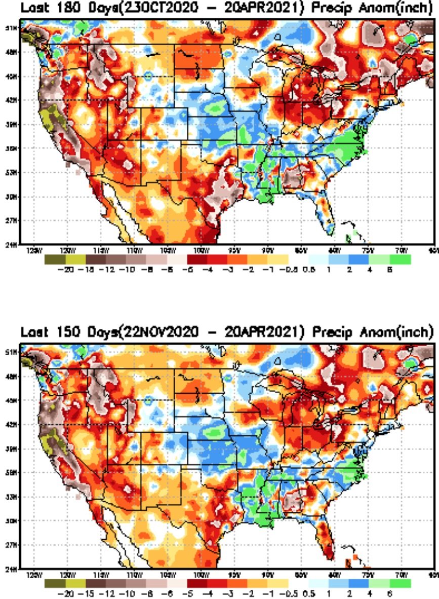
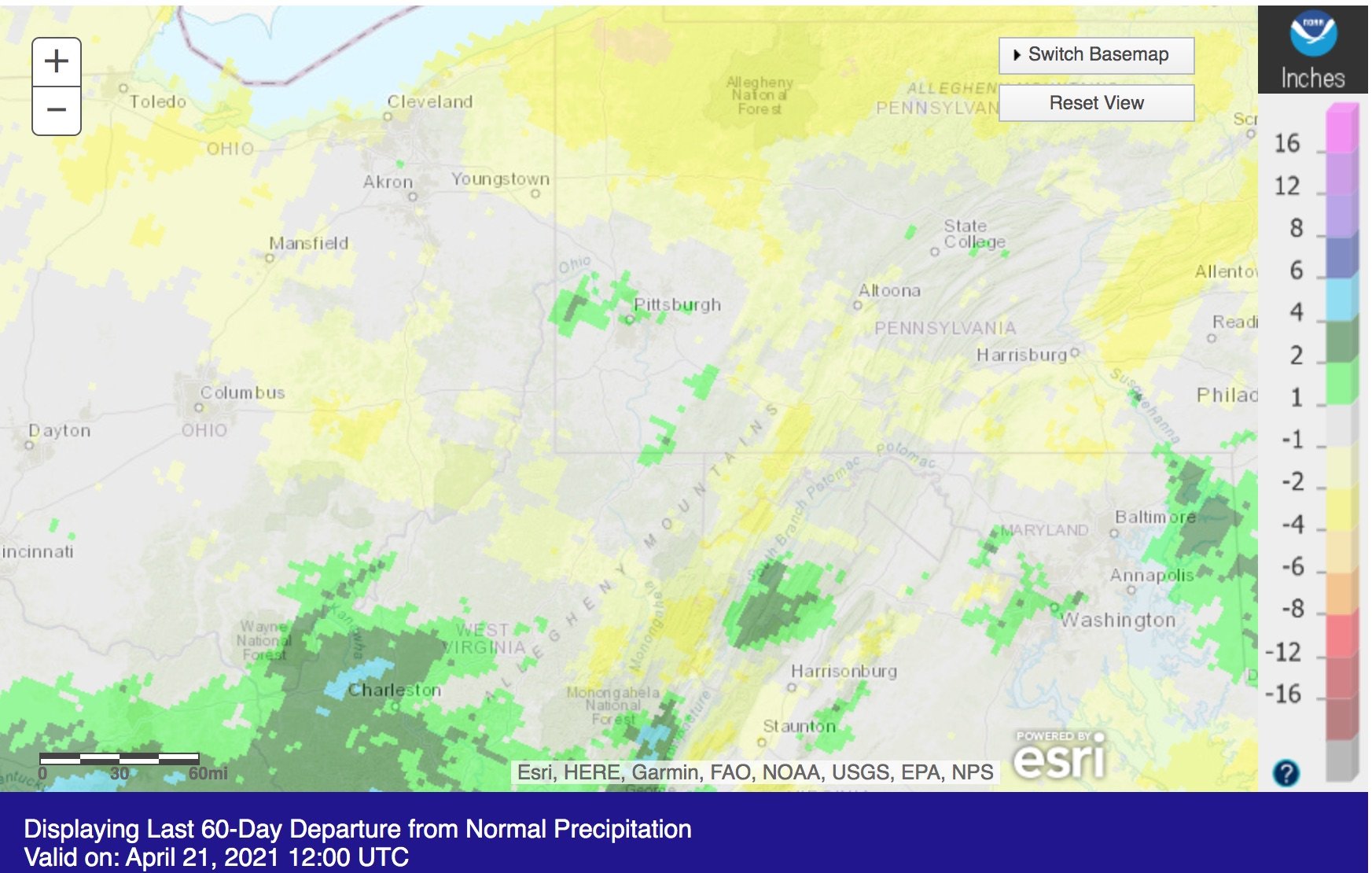
Hi All, lurked for a while, moderately recent transplant to the area from ATL after a ~2yr stint in Minnesota (was not prepared for -20F and lower temps, ha!) but I'll take cold over heat and humidity any day. I have an eng research bkgnd, love modeling&sim, meteorology, and the details. High pressure is my personal nemesis because I much prefer progressive patterns over stagnation, especially in the summer (heat, humidity). What made me join though is this: I find the local news, even our fcst office, always painting a sunnier picture (pun intended) than what's there: >20F over climatological norms during winter does not constitute a "nice day" nor does the lack of rain thus far this spring. We need some moisture that isn't in the form of snow melt because that's basically runoff, which is why there is a fire season in the spring. But the recent sunny days and above average temps with low humidity, beautiful as they may be, have really done a number on our soil moisture. The PA DEP USGS has drought indicators already going off and we're not even at the drier part of summer yet. Granted, a few strong rainy fronts would go a long way here, but with the ENSO setup and teleconnections, we aren't trending in the better direction.