donyewest
-
Posts
137 -
Joined
-
Last visited
Content Type
Profiles
Blogs
Forums
American Weather
Media Demo
Store
Gallery
Everything posted by donyewest
-
Pittsburgh/Western PA Spring 2023 Discussion
donyewest replied to Ahoff's topic in Upstate New York/Pennsylvania
We are going to get so much rain this weekend. Yuck. -
Gotta love it! I was out there in shorts walking the dog. Wish we had this all winter.
-
I agree with you and see your point. I was trying to illustrate that the "heatwave season" is, overall, growing in length while the cold season is losing ground at the same time. There's only 365 days in a year and the northern hemisphere has a longer summer than winter (darn our wobble) so that doesn't leave much give...summer is spreading it's legs.
-
Also saw this analysis showing that the "heat wave season" has increased in Pittsburgh by 40-60 days during period from 1961 through 2021:
-
I saw this analysis back in October:
-
I think that's the more likely scenario. I usually find a national discussion on SPC or WPC then hardly see any mention of it locally.
-
I really think that KPIT Met office and national WPC/SPC teams underestimate severe/extreme storm weather here. Aug 2021 there wasn't a mention of heavy rainfall risks but it managed to flash flood up here, most rain my neighbors had seen since Ivan. Oct 2021 they all worried about severe weather in Ohio that would die down before it got here and we wound up with tornados from here down to the WV border. The hail storms that hit last summer up in Mercer/Lawrence counties were surprise storms. I think that in the past, the Pittsburgh region did not have severe weather, but I think that has changed and they are constantly surprised. People are still surprised when they hear that Dixie Alley is a thing because people only think of the great plains when they hear tornado alley.
-
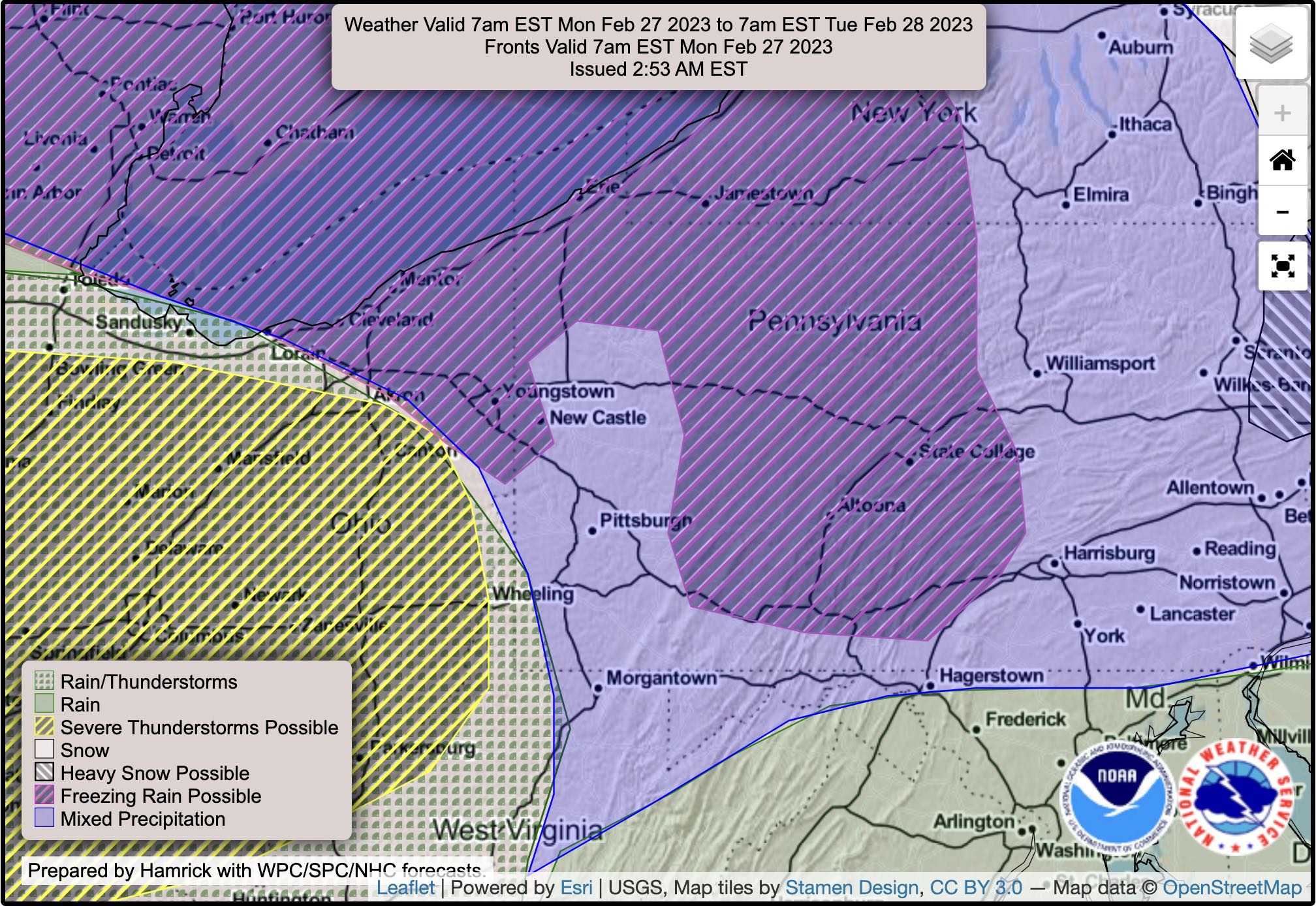
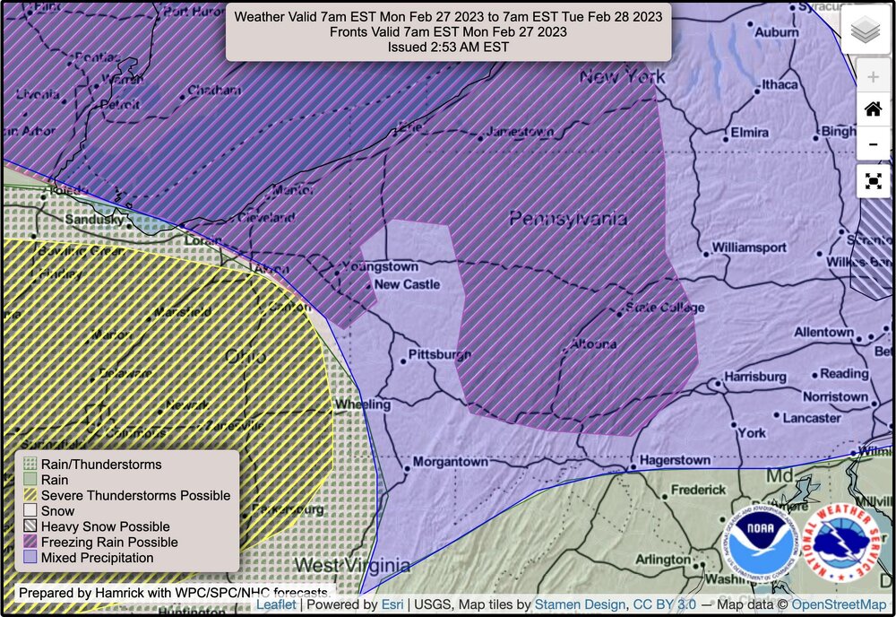
Had to laugh at the WPC national map, never saw one deliberately cut out such a small, well-defined area.
-
Dev team must have gone wild this winter on the GFS because the EPS (totally worth the membership cost after Pivotal Weather integrated it) shows us in the 50s on March 5 and 6 with a total snowfall of maaaaybe 2" from now through 00z March 07. ...2" of QPF same time frame I saw this interesting Tweet about the NCAR models showing that the response to the present (ongoing or done?) SSW may be very atypical: Cold goes where it's been cold and warm stays where it's been warm. I haven't had a chance to dig into it much but sounds like the NCAR model response was so atypical that it caught attention from several researchers I follow. Wouldn't surprise me in the least if this winter keeps it different but it would absolutely surprise me if we don't get the common cool Spring that typically happens after late SSWs/vortex reversal. Final cold air breakup not making it here would make this a warm Spring, fo sho.
-
Oh, I absolutely agree but I kinda wish the MET offices would move to superior techniques like curve fitting, change over time, differential calculus. Two simplistic "extreme" examples: 1. Person A, born and died at an average age all while living at sea level in Florida, but climbed Mt. Everest twice in their life for funsies. Person B, born and died at an average age all while living in our region ~1000ft above sea level, never left home. Who spent more of their life at a higher altitude? 2. Person X can swim half the length of an average sized pool at its maximum depth of 6ft. Person Y can only hold their breath long enough to swim straight down and touch the bottom of a 12ft pool then swim right back up. Who spent more time at the deeper depth? Official MET observations are taken at hourly intervals yet they figure average temperature from only the max and min. That's like saying we would have had a great winter if we catch up with all of our snow in March even if it melts in two days time. Extremes are important, outliers are necessary data points, but they can strongly skew averages. It took 4 days of -14F or more max/min departures in December to make that month come out to only -0.7F below average.
-
Averages are so mundane. I'd take a week of climatological norms with a day or two slightly above and below over 2-3 days of above average followed by 36hrs of far below average then 2-3 days of right back above average. That's winter weather versus a strong fall or spring cold front taking place in the middle of winter.
-
I know some of ya said a March storm would make up for no winter but I disagree. I can't be pacified with a late season snow storm with a March sun angle because then it is just work to shovel - it won't stick around at any depth worth having, it'll just become brown, mud snow.
-
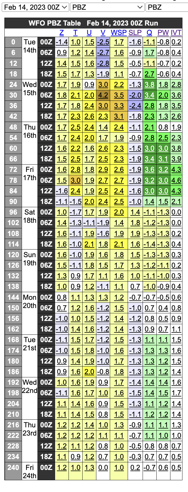
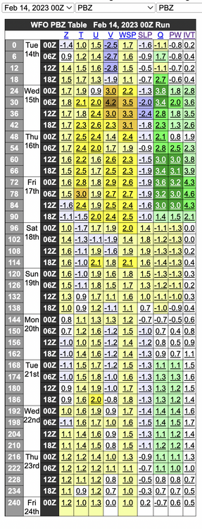
Every yellow->red tint is above average in standard deviations. Column "T" is temperature, "PW" is precipitable water, "Q" is humidity.
-
For real, on that topic, I'm 30mi away ENE "as the crow flies" and am on a well. I've had an undersink RO system where installing it has been on my todo list for ~5mo (busy, busy) but the charlie foxtrot of a response has forced my hand. I'm taking time off work to modify our cabinets to install it now. I know the water table here is highly unlikely to be affected but if the response there is any measurement to how ecological disaster responses are in the area then it is concerning. I have a Purple Air and PM2.5 did increase (because of the soot from the burn) but VOCs, which Vinyl Chloride is, were luckily within normal readings.
-
This is a good comparison. I honestly don't understand why we trust the precision or accuracy of measurements before 1940~1950. Instrumentation was rudimentary and nowhere near up to the specs or requirements we have for present-day. Official temperature readings are to be 2m off the ground, out of the sunlight, away from obstructions, and more. Downtown Pittsburgh was already sweltering because of industry during the early records, bias is everywhere, pointing at pre-1950 data is disingenuous at best.
-
It's 8:35pm in early February and the temperature is 62F.
-
Didn't mention it to my wife or anyone so as to not jinx all of us but I heard birds singing during that far above average run at the end of January. Early in the day too. I said to myself that it sounded like Spring and it was then that I knew our winter was in its last gasps.
-
I made that mistake last year right as the snow was melting and then we got two weeks of below 50F weather. I can't tell how people are supposed to seed their lawns here. Does everyone just buy sod? LOL
-
I went to bed after measuring ~1.25" last night from some of these streamer bands, very dry snow, likely that we topped out around ~1.5" by this AM.
-
Should have clarified I meant in more of a rhetorical, "larger picture" sense.
-
Honestly, the real surprise is that Lake Erie (and even Michigan) aren't frozen over enough at this point. Lake effect usually shuts off through winter because Erie gets too cold to produce lake effect snow bands.
-
Pittsburgh/Western PA Spring 2023 Discussion
donyewest replied to Ahoff's topic in Upstate New York/Pennsylvania
~40F with just enough pre-dawn snow to pi*s ya off and will be gone by 10AM from now until early May, lock it in. Get out your old sheets to cover those early plants from repeated, poorly advertised frosts. Excited for the abrupt changeover to 89F with 70%+ RH. -
Time to make a Spring thread lol (60/40 kidding/serious)
-
Still made it above average temps today.
-
Ha, they reduced snow totals for the backside of this storm significantly. It had read 1-3" tonight with >1" over the next few days. Now it's less than half an inch tonight and less than an inch tomorrow.