

George001
-
Posts
5,050 -
Joined
-
Last visited
Content Type
Profiles
Blogs
Forums
American Weather
Media Demo
Store
Gallery
Posts posted by George001
-
-
8 minutes ago, 40/70 Benchmark said:
Exactly.
Only one of those seasons had a major east coast event, which was the Jan 2000 mid atlantic system, which we apparently can't count since Georogie's hood smoked cirrus.
1955-1956 may have had one...decent season, and even 1975-1976 was respectable, but super el nino is more prone to big east coast storms.
28 minutes ago, 40/70 Benchmark said:Firstly, SW NE did get a good deal of snow from that Jan 2016 event, and the Dec 1997 was very prolific north of Boston, regardless of what took place in your back yard. Additionally, those three la nina events were barely over the strong threshold. Secondly, you can't count one season three times. 2/3 of those la nina seasons featured no major SNE events...all three of those super el nino seasons did.
Sorry, but you're wrong. The prominent STJ in stronger el nino seasons, while not ideal for this region, is better for the prospects of major winter storm than a strong la nina regime. Additionally, el nino is more highly correlated with neg NAO, than la nina, which is another reason why it is more beneficial.2010-2011 is the strong Nina on record going by MEI, so I would count it as a super Nina. Your other points are valid though, I focus too much on my backyard rather than the actual pattern in place when drawing my conclusions which is flawed logic. I’ll concede I was wrong about super ninas favoring more huge events than strong ninos, however I still would rather have a strong Nina. I would rather have a bunch of 6-12 type storms with cold nearby than have a super mild and snowless winter with one 2 footer that melts in 2 days.
-
2 hours ago, 40/70 Benchmark said:
Sure, maybe its easier to nickel and dime your way to a couple of forgettable extra inches in strong la nina, but odds of a big one are nearly nil in a very strong la nina.
Last three super el nino seasons:
1982-1983: Megalopolis blizzard.
1997-1998: Dec 23 bomb that dropped an 8"-spot on Ayer in an hour.
2015-2016- Top 3 mid atl blizzard.
I rest my case-
1997-1998 and 2015-2016 were garbage here with no big ones (18+) in New England (2016 missed to the south as is typical with strong ninos) only 1982-1983 had a massive blizzard in New England.
Last 3 super Nina seasons
2010-2011 3 massive blizzards bringing 18+ inches to areas of the region with several smaller events on top of that
2007-2008 no bigger storms, a bunch of 6-12 type storms.
1999-2000- garbage.
Conclusion: last 3 big ninas, 3 big ones. Last 3 big ninos, one big one. Big ninas are more favorable for big ones in New England than big ninos. In the Mid Atlantic, big ninos are much more favorable for big ones.
-
 2
2
-
-
Another reason why big ninos suck is not only do they screw us that year, but for the next several years until we cool off the ocean. Not saying it’s the Nina that does this, as that idea I had has been refuted, but maybe the atmosphere drivers that allow a big Nina to form cools off the ocean as well. Regardless, if we want pac help in the following years it would make sense to root for a big Nina. For example look at the big nino in 2009-2010. After that winter, we didn’t get a really favorable pac until 2013 (even the epic winter of 2010-2011 was mostly Atlantic driven). After the big Nina in 2010-2011, we had one garbage pac winter follow, then 3 consecutive great pac winters until the super nino in 2016. I strongly believe that the super nino of 2016 screwed us in the following winters as well and is why we haven’t had any pacific help since the epic 2014-2015 winter. If we had a big nina earlier like the year right after I don’t think we would have been stuck in pac hell for 5 straight years, but it would have been more like 2-3 years. Since we didn’t get any help to cool off the ocean there isn’t anything to stop the flow from getting flatter and mild air from flooding the country.
-
This is a quote taken from the mid Atlantic board. It seems to indicate that my previous idea of the pacific being on fire destroying our winter in the east has some merit. It also gives merit to my idea of strong ninas being necessary to cool off the ocean, otherwise the jet energy coming off from the pacific will intensify so much that it will overwhelm the pattern. It would both flood the country with warmth and flatten the flow. The strong nino in 2016 screwed us not only that winter but for the next several years as well, with there being only a few good periods (during ninas) in a period of warmth.
“Solar has been way, way off. That last cycle was weak(as predicted due to the sun going so quiet around 2010 I think). That definitely coincides with a lack of moderate/strong La Ninas. I always think moderate to strong La Ninas reset the temp gradient in the equatorial Pacific. For those of you who don't know what I am speaking of(I know Tellico does), we are used to weak El Ninos being great winter weather signals. However, for the El Nino to be a strong winter wx signal in the East, the Sea Surface Temps(SSTs) need to be colder in the places which are not part of the El Nino. The stronger that tempdifferential(the gradient) between the Nino and the rest of thePacific, the more likely the El Nino behaves as normal. With SSTs above normal in much of the Pac for the past 4-5 years, the Nino climatology was been washed out. I am hoping that this La Nina will allow the next Nino to have a stronger gradient and behave more as a Nino would. As Tellico notes, all of this is likely tied together. And again, the AMO cycle is only about 2/3 of the way through - maybe it will end early? I do hold out hope that this year's unexpected -NAO cycle this winter might well be a harbinger of better winters to come.”
-
2 hours ago, 40/70 Benchmark said:
That chart doesn't tell the whole story, either....the structure is very important. I will take a modoki el nino regardless of strength over any la nina.
I would take a -5 degree Celsius Nina over a moderate or stronger nino regardless of structure. 2009-2010 was supposedly modoki and that didn’t stop it from giving DC blizzard after blizzard while we got screwed. I can’t think of a single strong nino that produced an epic winter here, modoki or not. That said, I looked at another chart and it says that weak nino is the best for us out of all Enso states like you said. For my winter forecast, if I see a mod or strong nino I’m not forecasting more than 35-40 inches in Boston and that’s if every other factor is favorable. Only weak nino is good otherwise it’s congrats DC, Richmond, Baltimore, ect.
-
 1
1
-
-
11 minutes ago, weathafella said:
What is the average Boston snow for strong Nina vs strong nino?
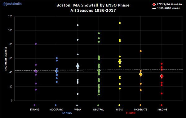 according to this chart, Boston averages around 40 in strong ninas and low 30s in Strong ninos. Weak ninos are actually really good here, but moderate and strong ninos suck here. That’s why it’s weird to me to see the strong Nina=ratter idea being thrown around on a New England forum, our chances in a strong Nina are around the same as our chances during an enso neutral winter. The only enso states that signal below-well below average are mod-strong ninos.
-
1 hour ago, 40/70 Benchmark said:
Big Ninas are generally hostile, anyway....that is an indisputable fact.
Least favorable ENSO state.
In DC I agree, but in southern New England ninas are generally better. I would rather have a record strong Nina than another strong nino, those always seem to screw us.
http://www.solarstorms.org/Boston.html
data shows that Boston averages more snow in ninas than ninos overall.
-
1 hour ago, CoastalWx said:
Yeah this year we had some bad luck too. Seemed like confluence was just enough to shear out systems coming from the Plains and southern US. The true arctic cold was really only the last two weeks and driven through the west and plains. But you can look at it alternatively. The confluence also helped reduce the cutter potential. There’s a good chance that without the confluence, storms would have been a lot milder for New England.
I agree, this winter left some on the table considering the pattern. A great example of bad luck is 2/1, I got about 8 inches but just a 30 min drive to the NW and there’s 18 inches of snow. My area wasn’t even the area to get screwed over the most, Boston got like 2 inches and just 10 miles to the NW had nearly 2 feet, thats about as sharp a gradient you can get. That’s just plain bad luck, in my opinion 9/10 winters with similar atmospheric drivers to this one would have SNE getting hammered with 70+ inches of snow (except maybe the cape, r/s lines are extremely hard to avoid there). The polar vortex was just a bit too far west, but it was close. It’s not like the last 2 years where it was sitting over the North Pole.
-
9 minutes ago, weathafella said:
No George you miss my point. 2nd year big ninas are most often terrible winters here.
Yeah I misunderstood your point, I thought you were saying Strong ninas in general are bad. I haven’t dug up the data yet on 2nd year mod-strong ninas yet but just off the top of my head we have 2011-2012, 2017-2018, and I believe there was one in the late 90s that sucked as well. If 2011-2012 is an analog that’s a very bad sign. I would have thought with 2 ninas in a row the Nina pattern would be more “set in” the second year so it would give us better chances and better winter patterns. It seems like the data is indicating the opposite, so how I thought it works is incorrect. Maybe it’s more like Rays load blown south west idea in that a miller a bombing out really far south isn’t necessarily good for us compared to a Miller B that bombs out over Nantucket. For the La Niña maybe the Nina “blows it’s load” and gives a more Nina pattern the first year but by the time the second year comes around the Nina, while still in place, isn’t really driving the pattern anymore. Another tricky aspect of forecasting is climate change, as certain atmospheric drivers that did one thing in the past may not do the same now with the warmer temps. For example a pattern with a bunch of marginal wet snow storms 50 years ago might just give us rain now.
-
32 minutes ago, weathafella said:
If we get a record strong nina next year after this years robust nina it typically means major major dead ratter next winter.
I disagree, the dead ratter Enso state in New England is a strong El Niño, that’s the enso state we avg the least amount of snow in. I’ll take a record strong Nina over a record strong El Niño any day. In fact the strongest La Niña on record, 2010-2011, was an epic winter NYC north. This winter ended up as an avg-above avg winter here, but was very close to being more. From what I read over at the pattern drivers thread the nina pattern didn’t really take over until Feb, which is when we got our snowiest month. I don’t really understand the anti Nina sentiment here, our area does fairly well in ninas, it’s the mid Atlantic that gets screwed by them. Ninos tend to screw us and be congrats DC when moderate or strong (we can do well in weak ninos though).
-
Just now, Hoth said:
How many yards for mby?
Right now I’m leaning big NYC north, because I believe there will be a record strong La Niña next year that will overwhelm and dominate the pattern (strength exceeding -2 degrees Celsius on both the ONI and MEI chart). I posted my reasoning behind why I believe we are going to have a record strong La Niña next winter, however it is WAY too early and if my idea about the enso state is wrong then I am going to have to adjust my preliminary thoughts. This is why I’m not planning on writing up my forecast until November.
-
 1
1
-
-
1 hour ago, CoastalWx said:
 Lots of money involved and more often than not, you go AN you’ll win. Short term aspects are harder to predict but DJF again will average AN. Snowfall and things like AO and NAO are harder to predict, but there are regimes that favor the positive and negative versions of those. I do agree the long term forecasts for snow were certainly much lower than reality.
Strongly agree that long range forecasts should hedge AN until proven otherwise. The world is a lot warmer than it used to be. Next year is going to be my first official winter forecast, I have already shifted my focus from this winter to next winters atmospheric drivers. My official winter forecast will be released in November 2021.
-
I just looked at the long range data and the La Niña has strengthened yet again, especially in the central and western pacific, with 1.2 degrees Celsius below normal in regions 3.4 and 4. This La Niña was approaching high end weak/low end moderate levels as in mid Jan but the La Niña is now back to solidly moderate strength La Niña, this isn’t quite the borderline strong Nina it was during late fall/early winter, but this restrengthening could possibly be the start of a second La Niña in the spring and summer. From what I know about la ninas is they typically peak in late fall or early winter, so a restrengthening in the spring is quite unusual, with the only years I can find doing this being 1975 and 1955, which isn’t enough of a sample size to draw any conclusions. Also both these were weak events at the time (this La Niña is moderate and peaked borderline strong) and the climate is much different (warmer) than it was then, so the only conclusion I can draw from this is that what is happening right now is very unusual. I’m not sure what is going on, but my hypothesis is that this restrengthening is the start of what will be a double peak La Niña event, with the first peak being late fall/early winter, and the second and much stronger peak being next fall, potentially rivaling the strength of the record breaking 2010-2011 La Niña (I know it is considered just a regular strong Nina going by ONI, but this La Niña was extremely west based so ONI undersells the true strength of this La Niña. According to the Multivariate Enso Index, which captures all regions of the pacific, this was the strongest Nina on record).
-
2
-
1
-
-
2 hours ago, CPcantmeasuresnow said:
And you shall remain George001 and not King George as some were ready to coronate you if you were right. Alas I was one of them, hoping you would wear the royal robes tonight.
There’s always next year, way too early to make a forecast but the long range models are hinting at the possibility of another La Niña, possibly even rivaling the strength of the 2010-2011 La Niña. if that verifies I’ll have lots of chances to become crowned King George.
-
20 minutes ago, HoarfrostHubb said:
No Georgie tonight? Or James?
I decided yesterday that I’m going to be checking out of this winter as long range guidance indicates the polar vortex is headed to the North Pole, and as long as that’s there I don’t expect another inch of snow this winter. I have been following this storm though and will report that I am at 4 inches or so, with what looks to be another inch or two as the final band of snow moves out, so it looks like I will end up at about 5-6 inches.
-
1
-
-
welp, I busted. My forecast was awful, there were a couple of red flags, such as the Euro and Navy being too far south with the low. I was banking on ratios to save us, while that idea of us getting good ratios was right (many areas received 20:1 ratios), there wasn’t enough QPF to get us anywhere near a foot. I’m probably going to end up around 5-6 inches when all is said and done. It was foolish of me to ignore the navy and euro, and to only side with the guidance that gave my area the most snow. Out west especially some areas got around 1/4 of what I forecast.
unfortunately, the polar vortex looks like it’s headed to the North Pole on the models so it looks like winter is coming to an end. Can’t complain though, this winter was great compared to the last 2 winters, which were as terrible as my forecasts.
-
1
-
-
It appears that the models have the polar vortex going over the North Pole in early March. I’m not optimistic at all anymore for March, in my opinion this is going to be the last storm we see this winter. It looks like my area is going to end up with 50 inches or so (10 more, from this storm+everything rest of feb into March) The pattern left a bit on the table but a 50 inch snow year is nothing to complain about in interior southeast mass, that’s a decent winter and way better than I thought with how things looked in November. My March forecast is gonna bust bad, I didn’t think the polar vortex would go to the North Pole but it looks like it will now. Oh well, at least the warmer weather will make for nice spring skiing as we head into mid March. It has been fun tracking but I’m gonna dip until next winter, and will definitely be taking advantage of what appears to be an early fishing season coming. Im going to use the site that was reccomended to me to do some reading over the summer, hopefully that will help me develop a better understanding that is reflected in the improved quality of my posts next winter. I will always be a weenie like Anthony and James are, but I would like to be a more knowledgeable weenie. One thing I will say, NNE posters like Dendy and Phineas will likely be very happy with the upcoming pattern, as it appears that there will be several rainstorms right over my house as we enter March. That’s usually good for you guys up there in terms of snow.
-
it seems like the shredder caps the ceiling, but doesn’t stop us from getting frequent 4-8/6-12 type events. It’s extremely problematic if you want a 2ft+ blizzard though. Fortunately it looks like it isn’t going to last for the rest of winter according to the long range data, so we should have our chances at least in the early part of March before we warm up.
edit- nevermind, while pattern is more amplified on the european guidance the polar vortex is over the North Pole so it torches us. We need changes to that, otherwise winter is over.
-
12 minutes ago, Go Kart Mozart said:
How much for tomorrow....a foot plus?
I have no idea at this point, I learned today that my beliefs in how the atmosphere works was WRONG. The se ridge+polar vortex in Maine actually does the opposite of what I thought, it does not create a boundary for cyclogenesis, but it shreds storms. Also we are in a fast flow pattern which makes bombogenesis more difficult to occur. La Niña also apparently doesn’t cool off the oceans like I thought, meteorology is complicated and not intuitive at all. My forecast could still be right, but if it is it will be because of the wrong reasons. I have a confession to make, I don’t really know anything whatsoever about meteorology, but I am trying to learn by making forecasts and when they bust doing a post Mortem to figure out where I went wrong. Regardless it was fun to track this storm and the post mortem analysis will be interesting.
One things that gives me hope though is often the bands push farther west than expected, which may help my forecast not turn into a total bust.
-
2 minutes ago, Kitzbuhel Craver said:
Lol, that radar looks pretty putrid...
Agree, hopefully it fills back in a bit so we can squeeze out an inch or two before the bigger storm tomorrow. Looked good this morning but it got SQUASHED.
-
Just now, 40/70 Benchmark said:
Very little ensemble support.
Yep ensembles want to squash the storm because they believe the flow will be fast. Operational runs have a more amplified system.
-
3 minutes ago, SJonesWX said:
don't forget:
1-3 in CNE/NNE
George of the jungle just pitched a tent
Dendy would love this. Feet of snow for him with rain over my noggin.
-
My forecast busted. This fast flow is a pain in the ass, hopefully it goes away in March.
-
17 minutes ago, Typhoon Tip said:
That's a repeating mantra I'm reading on this forum and it's not right really ... The system bombing does nothing up stream/ after the fact.
The "slowing" of the flow begins with whole scale meridian curvature - western ridging over N/America. That storm can bomb it's way across the N/Atlantic it has nothing to do with what is orchestrating from the lower OV-MA NE regions after the fact.
Im not sure I understand completely what you are saying, so correct me if I’m wrong. What I got out of this was my idea that we need a storm bombing out in the Atlantic to fix the flat flow problem isn’t correct, and it is the pacific side that is the problem here. From what I am seeing on the pacific side we have 2 competing factors, there is a strong La Niña in place to help cool off the oceans, which has allowed arctic air masses to enter the country and come south without much modification via pacific air. However right now the polar vortex is too far west, the energy rotating around the polar vortex is crashing into the west coast, not allowing western ridging over North America to develop. To fix this flat flow problem that is leading to shredding of storms we need the polar vortex to be farther east. I thought things were fine at least in New England unless the polar vortex was over the North Pole, but it appears that if we want something huge we need the polar vortex to be in central or eastern Canada. I’m not going to give up just yet though, I have been reading that there might be 1 more disruption to knock the polar vortex away from Alaska, and the key will be where does it get displaced to? If it’s over the North Pole we are getting an early spring, but if we can get it over central or eastern Canada we could get an epic March.
March 2021 Weather Discussion
in New England
Posted
I don’t buy the upcoming storm being wintry at all. The polar vortex is over the North Pole which won’t allow cold air to come in and give us a huge blizzard. That storm on the european guidance looks like its rain even into the mountains in VT/NH/ME. A polar vortex over the North Pole is the type of atmospheric driver that dominates the pattern, and as long as it’s there it’s nearly impossible to get a winter storm in the east.