

George001
-
Posts
6,339 -
Joined
-
Last visited
Content Type
Profiles
Blogs
Forums
American Weather
Media Demo
Store
Gallery
Posts posted by George001
-
-
3 minutes ago, 78Blizzard said:
The UK looks nice for the NYC and CT area, but probably a rainstorm for BOS south.
The low is a bit se of Nantucket that would be snow all the way to the cape with the airmass in place imo.
-
1 minute ago, RUNNAWAYICEBERG said:
It’s not the particular solution per say nor is it just one run. The trend has been nw for practically every model past several cycles. More corrections coming of course but don’t toss an inland runner idea at d5, that’s all. I’d probably toss bermuda lows though ha.
Theres so much cold air in place and a massive high to the north, not buying that it just moves outta there like that. GFS sucks, I’m all in with the NAVY.
-
 3
3
-
-
6 minutes ago, SouthCoastMA said:
ask yourself, if it showed a blizzard..would you be saying this.
Yes I would, I never use the GFS. Euro Canadian and Navy are the 3 models I look at mid range. Now my concern is the Euro and Canadian are inland, but the ensembles are farther SE while the navy has a blizzard. There is a lot of cold air in place so as long as the low doesn’t go west of us we should be fine.
-
5
-
-
Good thing it’s the GFS showing it, the GFS is horrible.
-
 2
2
-
2
-
-
Lol the low is going into Ontario. Maybe we can get it to trend so far west that it gets forced under by the trailing wave and turns into a Miller B instead on the Euro and Canadian guidance?
-
 1
1
-
-
10 minutes ago, Hoth said:
The NAVGEM is in your big three?
Yes I’m a big fan of the navy. Euro, Canadian, Navy are my favorite long range models. I wish the Navy had ensembles like the Euro and Canadian though.
-
1 minute ago, ORH_wxman said:
I don't mind a hugger...just don't track it over my fanny....even an LI to Cape track would be an awful lot of snow before any taint.
Wouldn’t that track snow everywhere NW of the low like Jan 2011 due to the airmass in place combined with how strong and wrapped up the storm is?
-
1
-
-
I’m on board. The big 3 is on board for a major storm. Canadian and European guidance is a bit inland and turns us to rain, and the Navy has a monster blizzard even on the cape. A blend of the guidance would be a track over the outer canal or so, which would be great for anyone NW of the low.
-
 2
2
-
-
HOLY SHIT LOOK AT THE NAVY! MONSTER BLIZZARD!!!!
-
1
-
2
-
 1
1
-
3
-
-
1 minute ago, NorEastermass128 said:
I share Ray’s dislike for the Miller A. I don’t do well in 90 percent of those. Granted, my location is especially hostile. Move just inland to say Woburn or west, you’ll still be able to get a sizeable event. Weenie me if you’d like. More often than not, a Miller A equals little snow here.
Yeah I’m rooting for this to morph into a Miller B. I hate Miller As
-
1
-
-
How much wiggle room is there with this one in terms of rain snow lines? I see that the Canadian is also inland so that can’t really be discounted. I know a track over NYC would rain here but if it were to say track over the canal would that be a snowy solution, or would the rain snow line go well inland of where the low is?
-
15 minutes ago, MJO812 said:
Not with the amount of cold air
I agree, there is a lot of cold air in place and also we have North Atlantic blocking for this storm. That will help prevent the low from running inland, I’m more worried about missing to the south.
-
3 minutes ago, 40/70 Benchmark said:
Monday is Miller A, too....
I thought some of the models had that as a Miller B? I hope we trend back to that I hate Miller As, I’m not interested in DC stealing all our snow. We need the evolution of the storm to change again…
-
5 minutes ago, 40/70 Benchmark said:
I do not trust Miller As for the life of me...they are to me what Miller B is to Baltimore, 9/10 times they will find a way to pork me to varying degrees. The only pure miller A off the top of my head that did not was the Megalopolis blizzard of Feb 1983....I actually got some cf naked twister in that one. The most prevalent issue with them is LBSW, but they are also more likely to take less than ideal tracks due to the longer distance traveled. Unreal how we haven't been able to buy a classic Miller B in 1.5 la nina seasons now. Save for maybe 2/1/21?
I’m with you on that, give me a Miller B over Miller A any day, that’s why I’m rooting for the Monday nor’easter over the Friday one.
-
This pattern seems to be wild, not the type of pattern where models will lock onto a big storm a week out and then hold it. In my opinion a big storm is going to pop up out of nowhere sometimes over the next few days on the models. It looks like the massive ocean low that at the moment looks like it’s going to miss to the south is buckling the flow. It looks like there is a strong piece of northern stream energy diving down behind the near miss ocean low on the Canadian, and it appears to be going out to sea harmlessly. On this run it does, but energy coming in behind it is just a few hours too late to phase in and hook that low back in, slamming eastern areas. The low gets all the way down to 975 mb even with a late phase, imagine how strong the low would be with a phase just a few hours earlier!
-
1
-
-
1 minute ago, Damage In Tolland said:
All signals I’ve seen have been pointing to a very early and warm spring start in Morch. Likely late Feb it ends
The La Niña is east based, that is usually good for Feb and March. I don’t think this winter is going anywhere, there’s still 2 and a half months left of winter.
-
1
-
-
2 minutes ago, weathafella said:
I would love winter to end mid to late February. Go south to thaw out snd prime for dews.
Considering that this winter got off to a slow start that would suck. I’m rooting for winter until late March
-
4 minutes ago, ORH_wxman said:
Yes. Still showing the -PNA returning for first week of February
Yuck I hope that’s wrong
-
1
-
-
Just now, SouthCoastMA said:
For the Euro, I only toggled between 12z today and 12z yesterday at 72 hours. It looked better, but then develops way off shore towards Bermuda. Needs some serious correction in the next 24 hours
That’s good for Sunday/Monday’s threat
-
1
-
-
7 minutes ago, 40/70 Benchmark said:
Relative to the pattern this season, EVERYONE in SNE has been porked....that is just fact. Sure, maybe the cosmic dildo that violated some is more jagged than that which entered others.
Yeah this winter got off to a slow start. The massive trough out west in December ruined what looked like a good pattern, but that looks to be changing soon.
-
I think we’re gonna get one of the 2 Friday or Sunday. Then there will be even more threats after that, this pattern is really good.
-
The Canadian has a Miller B on Sunday, I still think that’s the bigger threat but I’m starting to be more optimistic about the Friday one as well. The Navy is pretty far NW with that one, and that is a huge red flag because the Navy is known for having a SE bias. Id like to see the Euro and Canadian get on board for that as well before I go all in, but it’s worth keeping an eye on.
-
2
-
-
The euro op run was too far south, but it had a big storm which is nice to see this far out, the details can be worked out later. The ensembles improved and look better for our area, the mean at 180 hours is around 4 inches. Considering it has the Thursday storm whiff, that’s all next weekend. A mean of 4 inches that far out for 1 storm is huge. There are a decent amount of close misses on the indies, but several with massive blizzards.
-
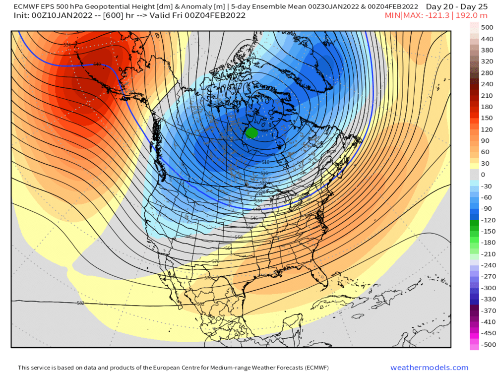
an interesting thing I noticed was the catalyst for this upcoming pattern appears to be a really good pacific and occasional blocking but nothing crazy. The NAO may actually average slightly positive for the month, unlike say a 2009-2010 pattern. With how good the pacific looks to be I’m thinking this could actually be good, in that it prevents suppression, leading to a pattern that is better for us than the mid Atlantic like 2014-2015.
-
1
-
Monitoring a potential important TV to East Coastal storm: Jan 17
in New England
Posted
Didn’t see the precip maps but if it goes from NYC to right over eastern mass that’s a step in the right direction. Still would be rain for my area, but even like 20 miles NW of my area would probably stay snow the whole storm and get a blizzard, rather than being confined to far inland. So far mixed signals, Canadian trended in the wrong direction Euro in the right direction. Models are still struggling with the pattern, hopefully the low doesn’t go inland at all.