

George001
-
Posts
6,318 -
Joined
-
Last visited
Content Type
Profiles
Blogs
Forums
American Weather
Media Demo
Store
Gallery
Posts posted by George001
-
-
Euro whiffs for the Friday storm but it looks like it’s trying for a Miller B with the next shortwave at hour 144.
-
2 hours ago, LVwxHistorian said:
Wow what's the hostility for?! I'm just trying to engender a spirited debate, there's no need for personal attacks, obviously none of you were debaters in high school! And I haven't called anyone a name.
I've already explained why I posted this: to understand why someone would make such a confident forecast with such a powerful storm so close, since I plan to be in that position one day.
Gosh, what sensitive weenies you all are!!
PS If you got a problem, report my posts -- I did yours!
I get it, sometimes forecasts even ones made by experienced meteorologists bust. Most forecasts had my area getting 3-6/4-8, and my area ended up with a foot. I used to think like you, it seems so easy, meteorologists get paid a lot of money just to be wrong. However, if you look into why and how they end up being wrong, all it takes is one little thing here, there ect and boom the low is 25 miles farther west than expected and the forecast ends up busting. That is within the range of error for model guidance even just a couple days out, and being only that little off in the track of the low is pretty good for 2 days out, but that’s just how the weather works, even 10 miles could be the difference between a few inches and a foot of snow. Im not a met and tried forecasting a few times for fun, and I was way way off. Making forecasts is extremely difficult with almost no room for error, so busts are going to happen. It’s like hitting in baseball, even the best hitters in the league fail 7/10 times! Criticizing meteorologists for busting often and saying they suck, anyone can do it ect is like criticizing the best hitters in the MLB for making an out over half the time. If you do that, you are drastically underestimating how difficult their professions are.
-
 2
2
-
-
What’s interesting is the extended range is trending better as well despite the strong polar vortex. The CFS has shifted from a blowtorch Feb to showing avg temps. There is also some ridging poking into Alaska which hopefully would counteract the limited North Atlantic blocking. We had blocking the entire December and nothing to show for it due to one of the worst pacific patterns on record. There was a massive trough out west.
-
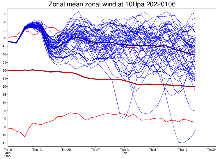 The polar vortex is extremely strong and is expected to deepen again, yet the pattern looks great on the models. Looking at this I would think 2011-2012, but that clearly isn’t the case. What’s going on here? I read that although the polar vortex is strong, it isn’t super consolidated, had a minor disruption already, and is expected to have another mid month. Or is it more that the pattern is being driven by other factors like the pacific and MJO? Maybe instead of an extended duration episode of North Atlantic blocking we score via a great pacific and overall positive NAO, but transient periods of blocking?
-
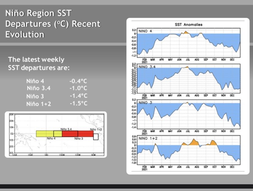
There has been an increase in strength with the La Niña over the past month, enough to be considered a moderate La Niña at -1.0 Celsius on the ONI trimonthly scale.
https://origin.cpc.ncep.noaa.gov/products/analysis_monitoring/ensostuff/ONI_v5.php
-
18 minutes ago, MJO812 said:
I'm already calling out of work for the Blizzard
*blizzards
-
1
-
 4
4
-
-
35 minutes ago, Sey-Mour Snow said:
Do yourselves a favor and check out Euro Control run today, 3 monster blizzards, day 8, day 11, day 14.. One for everyone, some get all 3..
If there is any pattern to deliver multiple blizzards to the area, it’s this one.
-
1 minute ago, 40/70 Benchmark said:
You making A snowmap, or wait til tonight?
Need to see more support from the big 3 (European, Canadian, Navy). The Navy isn’t in range yet, I could extrapolate it though. Canadian I’d like to see jump on board.
-
1
-
-
The european guidance had a 985 mb low offshore at 216 hours out. Miller B?
-
It’s not on the OP runs yet but the European and Canadian ensembles show what looks like a Miller B around the 16th. The upcoming pattern is looking great, but I’m rooting for Miller Bs instead of Miller As. Miller As can be nice, but it seems like most of our big storms (12+) are Miller Bs.
-
Ended up with 13-14 inches here, double what was forecasted last night.
-
On 12/2/2021 at 10:58 AM, George001 said:
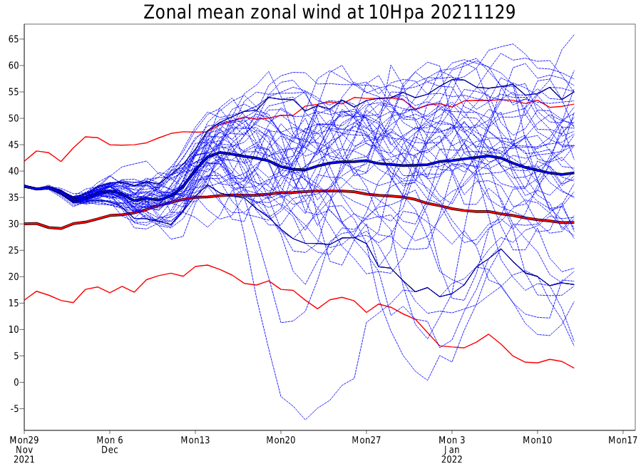
My winter forecast is going to BUST! I know I was calling for a big winter and pattern flip, but the recent guidance has changed with a polar vortex that is expected to deepen and remain stronger than average into mid Jan. The long range outlook for winter looks like shit right now, I hate to be an alarmist but I dont see how we are going to get North Atlantic blocking with a polar vortex this deep. Looking at the European guidance, the polar vortex isn’t consolidated over Eastern Canada, it’s over the North Pole. I’m very disappointed with the lack of North Atlantic blocking on the models, and honestly I’m really pissed off. I have been looking forward to a severe 2+ feet Boston blizzard this winter, I thought we would have 2 or 3 of em but now it’s looking like we won’t even get 1, last time my area had a severe 2 foot blizzard was March of 2018.
This is a fail, should have stuck to my guns.
-
8 minutes ago, wxsniss said:
Per Box twitter:
As of 1 PM, here are how our climate sites stand in terms of snowfall from the season's first major winter storm:
#Boston - 11.2 inches
#Worcester - 6.2 inches
#Providence - 5.9 inches
#Hartford - 5.4 inchesSnowiest January since 2018, and the great pattern is just getting started based on the long range guidance. This is why its good to let the winter develop and give it a chance before writing it off. When I made that panic room threat things looked bad, but I jumped the gun there.
-
1
-
-
1 minute ago, eduggs said:
None of the reporting stations in CT or EMA have recorded big liquid equivalent numbers. Maybe they underreport, I don't know. But at least in the NYC area, spotter reports and NWS measurements are showing 15:1 to 20:1 ratios.
Yeah I saw a report in Norwood (in the mega band) and 20:1 ratios with over a foot of snow was reported there. I’m not entirely sure how accurate it is, but I did see several reports saying ratios in that 20:1 range.
-
23 minutes ago, Tatamy said:
Looks like your forecast from several days ago panned out for those areas situated where the band set up. Nice work!
Thanks, It sure did! I’ve had a lot of busts (like last Monday) so its nice to be right about one.
-
8 minutes ago, STILL N OF PIKE said:
What a great snow storm for S CT to NE CT to NW RI to BOS S burbs. That band was magic
Solid storm in Bedford Mass - was def not staying in Nashua for this one
George - Geezus Christ .. good work
someone slap me
Looks like snow ratios were big in this storm, the QPF total was what the higher end of what guidance had (like eduggs said above) but the ratios were like 20:1 instead of 10:1, so those 10:1 snow maps ended up being an epic fail.
-
I don’t know if it means anything now, but the La Niña trending towards being more and more east based could be really good for later in the winter. The pattern looks to be really good for the rest of Jan on the long range models, could the East based nature of the Nina help us in Feb and March?
-
I’m eyeballing 12-13 inches, what a storm!
-
1
-
-
The latest hrrr has about 4-6 more inches of 10:1 ratio snow in eastern mass (in the heavy bands there are reports of 20:1+ ratios) it started running this hour, so that’s on top of what has already fallen. The funny thing is, the QPF output is actually HIGHER now than it was for the entire storm on some of the weaker runs last night.
-
Just now, ineedsnow said:
great now every call will be feet for all
 congrats man
Thanks lol I’m already at around 10 inches and it’s still puking snow. What a storm!
-
2
-
-
My forecast might have been too conservative for once
-
6 minutes ago, WinterWolf said:
Said he wasn’t feeling too good, so went back to bed. He worried himself to a case of the flu.
He gonna wake up a very happy weenie like I did.
-
I’m eyeballing 6-7 inches…. holy shit
-
2
-
-
The latest hrrr has .6-.7 more QPF for eastern mass, that’s on top of the snow that has already fallen. Ratios have reportedly been as high as 15:1 or 20:1, so extrapolating that for my area we would have 9-14 more inches on top of the 4 or so inches we already had (last I checked). That would result in a 13-18 inch storm total if correct.
January 2022 Obs/Disco
in New England
Posted
I’m higher on the Sunday/Monday one because it’s a Miller B and the Thursday/Friday one is a Miller A that originates 100 miles se of the Carolina coast. It could hook back in and whack us, but based on how the pattern looks on the guidance I think it’s going to slip south. The Sunday/Monday one on the other hand….