

Mount Joy Snowman
-
Posts
4,984 -
Joined
-
Last visited
Content Type
Profiles
Blogs
Forums
American Weather
Media Demo
Store
Gallery
Everything posted by Mount Joy Snowman
-

Central PA Summer 2026 Discussion/Obs Thread
Mount Joy Snowman replied to Voyager's topic in Upstate New York/Pennsylvania
Low of only 73 to go along with .01” of rain. -
Central PA Summer 2026 Discussion/Obs Thread
Mount Joy Snowman replied to Voyager's topic in Upstate New York/Pennsylvania
Just got dumped on for 30 seconds haha this is amazing. Didnt put a dent in the fire duh. -
Central PA Summer 2026 Discussion/Obs Thread
Mount Joy Snowman replied to Voyager's topic in Upstate New York/Pennsylvania
A rouge shower just rolled thru. Who knew!? -
Central PA Summer 2026 Discussion/Obs Thread
Mount Joy Snowman replied to Voyager's topic in Upstate New York/Pennsylvania
You know it! -
Central PA Summer 2026 Discussion/Obs Thread
Mount Joy Snowman replied to Voyager's topic in Upstate New York/Pennsylvania
I built a camp fire tonight like an idiot. But also, it’s always a good night for a fire. -
Central PA Summer 2026 Discussion/Obs Thread
Mount Joy Snowman replied to Voyager's topic in Upstate New York/Pennsylvania
Low of 65. Just did some yard work and it’s hot out there already. Might hit the river. -
Central PA Summer 2026 Discussion/Obs Thread
Mount Joy Snowman replied to Voyager's topic in Upstate New York/Pennsylvania
Low of 66. Happy Friday. -
Central PA Summer 2026 Discussion/Obs Thread
Mount Joy Snowman replied to Voyager's topic in Upstate New York/Pennsylvania
Low of 65. -
Central PA Summer 2026 Discussion/Obs Thread
Mount Joy Snowman replied to Voyager's topic in Upstate New York/Pennsylvania
Sorry a bit late on this, but crystal ball says July will end with a mean temp of 78.0 -- tied with 1993 for 25th place all-time. Book it. Pretty remarkable considering where we were sitting after the first five days of the month. -
Central PA Summer 2026 Discussion/Obs Thread
Mount Joy Snowman replied to Voyager's topic in Upstate New York/Pennsylvania
Low of 66 with .3” of rain. A few beautiful days ahead. -
Central PA Summer 2026 Discussion/Obs Thread
Mount Joy Snowman replied to Voyager's topic in Upstate New York/Pennsylvania
Had to haha. We waited as long as we could but had to leave or would have missed the train. We were soaked from the knees down. Saw a couple people without umbrellas that looked like Swamp Thing. It was one heck of a storm but much less exciting down here at home. -
Central PA Summer 2026 Discussion/Obs Thread
Mount Joy Snowman replied to Voyager's topic in Upstate New York/Pennsylvania
Just had maybe my most insane walk ever through harrisburg, absolute deluge with constant lightning. Had a strike hit right near us as we entered the train station that scared the pants off everyone. Fun. -
Central PA Summer 2026 Discussion/Obs Thread
Mount Joy Snowman replied to Voyager's topic in Upstate New York/Pennsylvania
Low of 70 with .01” of rain. -
Central PA Summer 2026 Discussion/Obs Thread
Mount Joy Snowman replied to Voyager's topic in Upstate New York/Pennsylvania
Low of 64. Hopefully some beneficial storms in our future. -
Central PA Summer 2026 Discussion/Obs Thread
Mount Joy Snowman replied to Voyager's topic in Upstate New York/Pennsylvania
Low of 62. Boat day. -
Central PA Summer 2026 Discussion/Obs Thread
Mount Joy Snowman replied to Voyager's topic in Upstate New York/Pennsylvania
Low of 61. @Blizzard of 93 I’ll do the calculation Monday morning, have a busy weekend. Enjoy it y’all! -
Central PA Summer 2026 Discussion/Obs Thread
Mount Joy Snowman replied to Voyager's topic in Upstate New York/Pennsylvania
Nope, beautiful day. I think it was just his time ha. Yeah I have a neighbor who is a tree guy and his crew is here right now taking care of it, glad it's nice conditions for them. -
Central PA Summer 2026 Discussion/Obs Thread
Mount Joy Snowman replied to Voyager's topic in Upstate New York/Pennsylvania
For @Yardstickgozinya or any other tree dudes who want to chime in. Pic of the uprooted base.....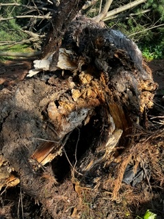
-
Central PA Summer 2026 Discussion/Obs Thread
Mount Joy Snowman replied to Voyager's topic in Upstate New York/Pennsylvania
It was a white pine. I’m not entirely sure but the root ball does appear to have some rot and be a bit bundled. Maybe I’ll take a picture of the exposed root ball later and post it here and you can give me your thoughts. We do have a couple more of these pines but not quite as large or leaning. -
Central PA Summer 2026 Discussion/Obs Thread
Mount Joy Snowman replied to Voyager's topic in Upstate New York/Pennsylvania
Low of 54. Perfect days. Happy Friday. -
Central PA Summer 2026 Discussion/Obs Thread
Mount Joy Snowman replied to Voyager's topic in Upstate New York/Pennsylvania
Yeah it seems there was some internal rot but showed no exterior signs. Always looked very healthy and put off lots of new growth. I will say it was a leaner. From the moment we moved into this house I knew it could eventually go, despite its massive size and healthy appearance. The lean was in a direction away from the house so we never worried about it too much and luckily it played out that way. -
Central PA Summer 2026 Discussion/Obs Thread
Mount Joy Snowman replied to Voyager's topic in Upstate New York/Pennsylvania
Low of 55. Beautiful days. Had our largest tree, a two and a half foot diameter pine, fall out of the blue yesterday. Luckily it didn’t take out anything structural but it fell into some other trees and my neighbor’s yard, so quite the mess to deal with over here. -
Central PA Summer 2026 Discussion/Obs Thread
Mount Joy Snowman replied to Voyager's topic in Upstate New York/Pennsylvania
Low of 69 with a paltry .01” of rain. Just too much cloud debris around yesterday to ever really get things going. Good news is the upcoming stretch of weather is about as good as it gets for late July. Enjoy. -
Central PA Summer 2026 Discussion/Obs Thread
Mount Joy Snowman replied to Voyager's topic in Upstate New York/Pennsylvania
A complete dud down this way with respect to any type of meaningful rain or severe. -
Central PA Summer 2026 Discussion/Obs Thread
Mount Joy Snowman replied to Voyager's topic in Upstate New York/Pennsylvania
I hear ya, hoping for the same. Latest HRRR loves that 4-6pm timeframe for a juicy line to come through. I got .19" over the weekend but have 5.8" for the month.


