TimB
-
Posts
17,230 -
Joined
Content Type
Profiles
Blogs
Forums
American Weather
Media Demo
Store
Gallery
Everything posted by TimB
-
Do you think that woman with the fat husband that you took a picture of mowing her lawn heard you?
-

Pittsburgh/Western PA WINTER ‘25/‘26
TimB replied to Burghblizz's topic in Upstate New York/Pennsylvania
Yes. P-types all over the place but the GFS has improved a bit from the true cutter look it had been depicting. -
Pittsburgh/Western PA WINTER ‘25/‘26
TimB replied to Burghblizz's topic in Upstate New York/Pennsylvania
Looks like it’s missing the NWS office by what, a mile? -
Pittsburgh/Western PA WINTER ‘25/‘26
TimB replied to Burghblizz's topic in Upstate New York/Pennsylvania
Man, I can hear the line blowing in. This is awesome. -
Pittsburgh/Western PA WINTER ‘25/‘26
TimB replied to Burghblizz's topic in Upstate New York/Pennsylvania
-
Pittsburgh/Western PA WINTER ‘25/‘26
TimB replied to Burghblizz's topic in Upstate New York/Pennsylvania
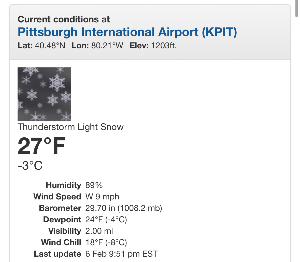
Hourly obs at KPIT reported thunder. -
Pittsburgh/Western PA WINTER ‘25/‘26
TimB replied to Burghblizz's topic in Upstate New York/Pennsylvania
You must be right under that western cell, which looks like the best part of the line. -
Pittsburgh/Western PA WINTER ‘25/‘26
TimB replied to Burghblizz's topic in Upstate New York/Pennsylvania
That’s corroborated by the ASOS.
-
Pittsburgh/Western PA WINTER ‘25/‘26
TimB replied to Burghblizz's topic in Upstate New York/Pennsylvania
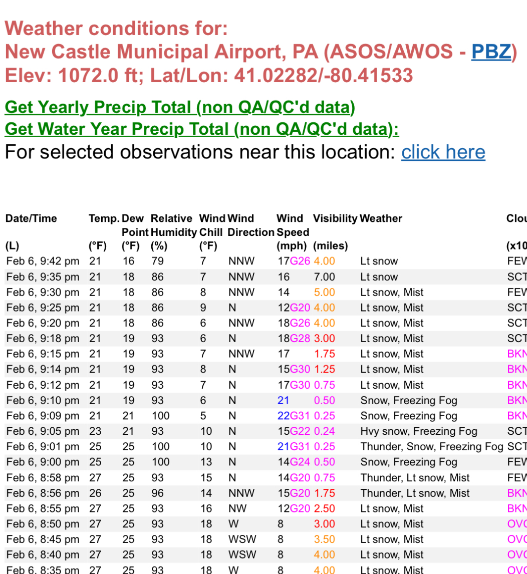
I guess KUCP (New Castle) had a thundersnow obs at 9:01. -
Pittsburgh/Western PA WINTER ‘25/‘26
TimB replied to Burghblizz's topic in Upstate New York/Pennsylvania
Any more other than those couple strikes near Youngstown? -
Pittsburgh/Western PA WINTER ‘25/‘26
TimB replied to Burghblizz's topic in Upstate New York/Pennsylvania
Yikes, did we even get half an inch? -
Pittsburgh/Western PA WINTER ‘25/‘26
TimB replied to Burghblizz's topic in Upstate New York/Pennsylvania
Dry slotted to hell. Wonder if we even get an inch. -
Pittsburgh/Western PA WINTER ‘25/‘26
TimB replied to Burghblizz's topic in Upstate New York/Pennsylvania
This clipper is starting to look like a dud. Radar looks pretty sparse so far. Hope I’m wrong. -
Pittsburgh/Western PA WINTER ‘25/‘26
TimB replied to Burghblizz's topic in Upstate New York/Pennsylvania
Just feels like there’s still a very real path to snatch defeat from the jaws of victory and somehow fall short of normal annual snowfall despite already being at 36” for the season as of 1/25. -
Pittsburgh/Western PA WINTER ‘25/‘26
TimB replied to Burghblizz's topic in Upstate New York/Pennsylvania
Is it just me or is tomorrow’s clipper looking a bit more meh as it approaches? Like closer to 1” rather than 2 or 3 if we’re lucky? -
Central PA Banter (Banter Less?) Thread
TimB replied to Itstrainingtime's topic in Upstate New York/Pennsylvania
You’ve been talking about divorcing your wife for years now. Just do it already. -
Pittsburgh/Western PA WINTER ‘25/‘26
TimB replied to Burghblizz's topic in Upstate New York/Pennsylvania
NWS seems pretty confident in the clipper on Friday. 80% chance of snow. About the highest I’ve seen for day 7. -
Pittsburgh/Western PA WINTER ‘25/‘26
TimB replied to Burghblizz's topic in Upstate New York/Pennsylvania
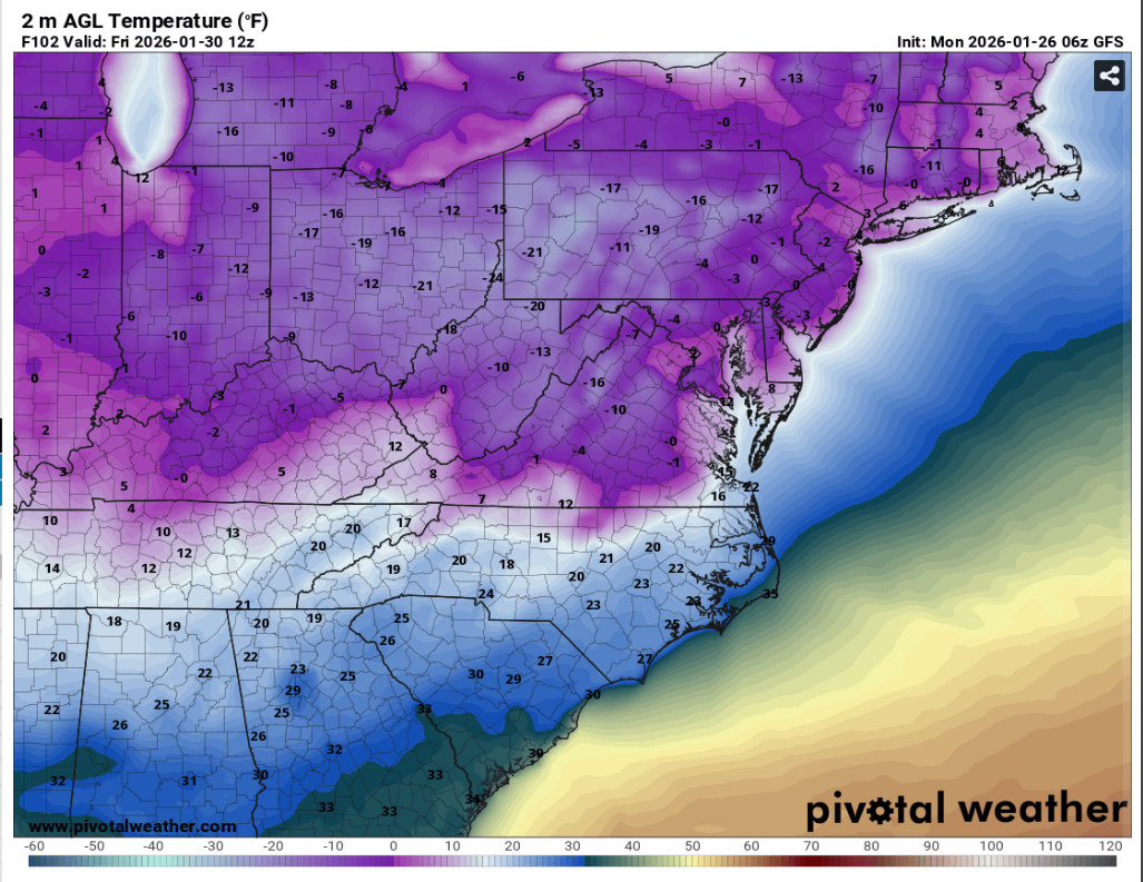
It’s now made it to -11 there for the first time since 1994. -
Pittsburgh/Western PA WINTER ‘25/‘26
TimB replied to Burghblizz's topic in Upstate New York/Pennsylvania
There were weather stations in northern Butler County in the -25 to -30 range this morning. Of course, we didn’t radiate nearly that well down here. -
Pittsburgh/Western PA WINTER ‘25/‘26
TimB replied to Burghblizz's topic in Upstate New York/Pennsylvania
Interested to see if we get better radiational cooling conditions tonight and/or tomorrow night and see how cold we can go, or if it’ll just be kinda meh like the last few nights. -
Pittsburgh/Western PA WINTER ‘25/‘26
TimB replied to Burghblizz's topic in Upstate New York/Pennsylvania
Yeah the other day I was out for a walk with the dog and it was snowing and there was barely a cloud in the sky. -
Pittsburgh/Western PA WINTER ‘25/‘26
TimB replied to Burghblizz's topic in Upstate New York/Pennsylvania
I’d question whether we “officially” get below zero any mornings other than Friday and Saturday, which look like slam dunks, but even those don’t look like spectacular radiational cooling nights. We just don’t do radiational cooling well in this region in general due to cloud cover, but the airport does it especially poorly. -
Pittsburgh/Western PA WINTER ‘25/‘26
TimB replied to Burghblizz's topic in Upstate New York/Pennsylvania
Record is 7 in Feb 1899. We had 6 in Jan 1936 and a bunch of years with 4 (most recently the 1994 one that includes our all timer of -22). -
Pittsburgh/Western PA WINTER ‘25/‘26
TimB replied to Burghblizz's topic in Upstate New York/Pennsylvania
The problem is, with the liquid equivalent and snow accumulation being observed at different sites, we don’t really have an apples to apples comparison. @TheClimateChanger does the NWS office have some sort of ASOS/AWOS or just snow obs and that’s it? -
Pittsburgh/Western PA WINTER ‘25/‘26
TimB replied to Burghblizz's topic in Upstate New York/Pennsylvania
This would be brutal.