

TimB
-
Posts
17,213 -
Joined
Content Type
Profiles
Blogs
Forums
American Weather
Media Demo
Store
Gallery
Everything posted by TimB
-
Fair enough. Merry Christmas, enjoy the (still somewhat rare) treat of getting to wear shorts on Christmas!
-
If you’re looking for warning signs, the 500 maps on the GEFS do have an awful lot of red floating around. It’s not as bad as the Canadian ensemble where you can already see the end of the pattern by the end of the run, but things decisively moved a bad direction overnight on several models.
-
The thing I noticed on the 6z GFS is it suddenly has this idea that it’s going to take much longer for “cold enough” weather to arrive. The positive height anomalies remain entrenched, and what once looked like a seasonable weekend with highs in the 30s and lows comfortably below freezing now looks like a warm-ish weekend with highs in the 40s and lows not hitting the freezing mark. In fact, the first freezing temp on the entire run occurs around hour 240, in the wee hours of Jan 3. So instead of 4 or 5 days until it feels like winter again, the GFS thinks it’ll be 10. That’s a huge change if it’s onto something.
-
Quiet in here. I assume the day 14 storm was gone on the 18z?
-
Nah. He’s so close to getting it, even if “in our current warm cycle” has no place on a science-based forum.
-

Pittsburgh, Pa Winter 2023-24 Thread.
TimB replied to meatwad's topic in Upstate New York/Pennsylvania
Hard to tell, honestly. You know what I think of the old records but it’s the only records we have so what can you do? -
Probably more legitimate than splicing PWS data into existing threaded records from other observing sites but beggars can’t be choosers.
-
Pittsburgh, Pa Winter 2023-24 Thread.
TimB replied to meatwad's topic in Upstate New York/Pennsylvania
With our next shot at getting below freezing not until Friday, we’ve likely clinched a spot in the top 10 fewest December days that have reached the freezing mark, as the best we can do is 13 days if Friday, Saturday and Sunday all get below freezing. Note that only one of the years with 14 or fewer days getting below freezing was observed at KPIT, and it was 2015 which is the standard bearer for awful Decembers.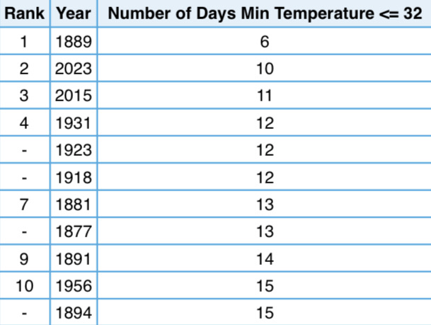
-
Can’t win, I made a comment that was a statement of fact from a model run and not even negative from a standpoint of people who want snow.
-
Helps that modeled temps are sitting in the lower 20s at the height of that thing.
-
Not sure where all the anger in this thread is coming from, is it that we’re headed towards another Christmas with highs in the 50s and not even a hint of snow or is it something else?
-
As always, I hope you’re right and the CPC is wrong. I’m not ready to throw in the towel yet, but it’s been a pretty demoralizing run for a winter and a half.
-
It’s a PSU thing. Years of being the cupcake opponent on Michigan and OSU’s schedule have given him a complex.
-
Oof. Looks like it coincides with a bone dry period.
-
The seasonable period looks dry as hell. It’s going to take tremendous luck to see any meaningful snowfall before at least mid-January, and that’s 4 weeks away.
-
Uh oh
-
Oh and also the signal for negative height anomalies in the longer term is much more muted in the long range GEPS and EPS. The GEFS is the only one keeping the faith that it’s more than a few days of kinda cold.
-
This is absolutely what @Bubbler86does as well. He’ll tell you so himself.
-
Pittsburgh, Pa Winter 2023-24 Thread.
TimB replied to meatwad's topic in Upstate New York/Pennsylvania
Yes. NWS went all snow with their forecast, but then there was a lot of mixing early on and his backyard allegedly fell short of warning criteria. -
Pittsburgh, Pa Winter 2023-24 Thread.
TimB replied to meatwad's topic in Upstate New York/Pennsylvania
We fell short of those totals (right @KPITSnow), but I’d imagine PBZ’s whole area aside from maybe the far western Ohio counties were under a warning. -
Pittsburgh, Pa Winter 2023-24 Thread.
TimB replied to meatwad's topic in Upstate New York/Pennsylvania
I feel like that may have been one where they just rolled with an advisory and it overperformed. Am I wrong? Edit: It looks like we had a watch that was later downgraded to an advisory, which they kept through the duration of the event. So we had a watch then, but the last time Allegheny county was pink was in January 2022. -
Pittsburgh, Pa Winter 2023-24 Thread.
TimB replied to meatwad's topic in Upstate New York/Pennsylvania
From last night’s forecast discussion: You’d think the NWS would learn that every time they do this, their forecast busts. Forecast low at PIT was 23, actual low was 30. -
Pittsburgh, Pa Winter 2023-24 Thread.
TimB replied to meatwad's topic in Upstate New York/Pennsylvania
I wasn’t impressed with how fleeting the cold was on the GEFS either. -
xmACIS doesn’t give you that option when doing 5 year periods, but 1/1 to 12/31 is sufficient when measuring the “least snowy 5 year periods.” It’s a little less useful when doing 1 year increments.
-
Pittsburgh, Pa Winter 2023-24 Thread.
TimB replied to meatwad's topic in Upstate New York/Pennsylvania
With that said, the 18z had signs of promise for a second but was then an absolute nightmare.

