TimB
-
Posts
17,206 -
Joined
Content Type
Profiles
Blogs
Forums
American Weather
Media Demo
Store
Gallery
Everything posted by TimB
-

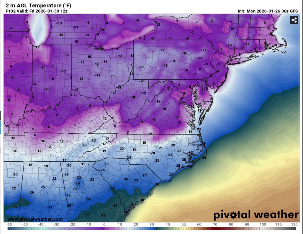
Pittsburgh/Western PA WINTER ‘25/‘26
TimB replied to Burghblizz's topic in Upstate New York/Pennsylvania
This would be brutal.
-
Pittsburgh/Western PA WINTER ‘25/‘26
TimB replied to Burghblizz's topic in Upstate New York/Pennsylvania
For those hours when the NWS was adding .4” to the total, the airport ASOS station was recording .08” liquid equivalent. Did our ratios drop as low as 5:1? -
Pittsburgh/Western PA WINTER ‘25/‘26
TimB replied to Burghblizz's topic in Upstate New York/Pennsylvania
At the end of the day I’d take another 2016 over something like 1/19/19. It could be a whole lot worse than getting a high end advisory snowfall. -
Pittsburgh/Western PA WINTER ‘25/‘26
TimB replied to Burghblizz's topic in Upstate New York/Pennsylvania
First off, this was a deeply satisfying storm and I got just a hair over a foot imby, and it sounds like many of us did. It seems the official obs is consistent with a lot of the other obs in the western part of the county, so I don’t think I have an issue with the measurement itself. I’ll agree that the calendar day thing is a bit silly, so let’s go by individual storms instead. Pittsburgh has had 27 two-day official storm totals of 12”+, most recently, of course, in 2010. The 16 years (and now still counting) that have passed since our last one is still the longest drought by that metric. With that being said, it’s only January 25 and we’re only about 8” away from getting our first above normal snow season since 2021-22, and that one was only because we lucked into above normal with some late season stuff. We’ve had two winter months with below normal temperatures and above normal snowfall. Winter has finally wintered again, and it’s been fantastic so far. Let’s bring the rest of this one home! -
Pittsburgh/Western PA WINTER ‘25/‘26
TimB replied to Burghblizz's topic in Upstate New York/Pennsylvania
Forecast discussion says the NWS obs at 7pm was 10.7”. We tried. -
Pittsburgh/Western PA WINTER ‘25/‘26
TimB replied to Burghblizz's topic in Upstate New York/Pennsylvania
Is this actual heavy snow coming or sleet mixed in? -
Pittsburgh/Western PA WINTER ‘25/‘26
TimB replied to Burghblizz's topic in Upstate New York/Pennsylvania
I mean, is there even one person in this sub who thinks New Englanders are good people who deserve two epically good things on the same day? -
Pittsburgh/Western PA WINTER ‘25/‘26
TimB replied to Burghblizz's topic in Upstate New York/Pennsylvania
Just remember, Boston is jackpotting on this storm and the Patriots are about to punch their ticket to the Super Bowl. -
Pittsburgh/Western PA WINTER ‘25/‘26
TimB replied to Burghblizz's topic in Upstate New York/Pennsylvania
NWS obs is up to 10.2” as of 5pm. -
Pittsburgh/Western PA WINTER ‘25/‘26
TimB replied to Burghblizz's topic in Upstate New York/Pennsylvania
Daily climo report as of 4pm: Still need 2.2… SNOWFALL (IN) TODAY 9.8 R -
Pittsburgh/Western PA WINTER ‘25/‘26
TimB replied to Burghblizz's topic in Upstate New York/Pennsylvania
At the end of the day, this event is likely going to make it into the Hall of Really Good in our local area but not the Hall of Fame. And that’s fine. It’s been awhile since we’ve even had something like this. Snowmageddon II will have to wait. -
Pittsburgh/Western PA WINTER ‘25/‘26
TimB replied to Burghblizz's topic in Upstate New York/Pennsylvania
A large amount of our region will, but I’m beginning to question whether or not our 30+ year streak without 12” in a single day at the official observation site might actually somehow continue. -
Pittsburgh/Western PA WINTER ‘25/‘26
TimB replied to Burghblizz's topic in Upstate New York/Pennsylvania
About to get into some lighter snow? -
Pittsburgh/Western PA WINTER ‘25/‘26
TimB replied to Burghblizz's topic in Upstate New York/Pennsylvania
You could make a case for 2016 but that wasn’t region wide, only the southern parts got there. -
Pittsburgh/Western PA WINTER ‘25/‘26
TimB replied to Burghblizz's topic in Upstate New York/Pennsylvania
When was our last big January snow? 1996? Has it been that long? -
Pittsburgh/Western PA WINTER ‘25/‘26
TimB replied to Burghblizz's topic in Upstate New York/Pennsylvania
Yeah it filled back in. Decent radar returns as the precip gets closer to the radar. -
Pittsburgh/Western PA WINTER ‘25/‘26
TimB replied to Burghblizz's topic in Upstate New York/Pennsylvania
By the time it gets here (if it does at all), we could have a ton of snow on the ground. I wouldn’t fret. -
Pittsburgh/Western PA WINTER ‘25/‘26
TimB replied to Burghblizz's topic in Upstate New York/Pennsylvania
Now whether that mixing makes it another 50 miles NE with that batch is hopefully a different story. -
Pittsburgh/Western PA WINTER ‘25/‘26
TimB replied to Burghblizz's topic in Upstate New York/Pennsylvania
Mixing. Correlation coefficient tells all.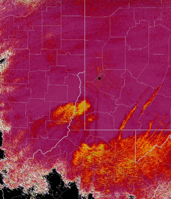
-
Pittsburgh/Western PA WINTER ‘25/‘26
TimB replied to Burghblizz's topic in Upstate New York/Pennsylvania
Sadly, shows some mix. -
Pittsburgh/Western PA WINTER ‘25/‘26
TimB replied to Burghblizz's topic in Upstate New York/Pennsylvania
Good lord, 50-55 dbz returns in that Wheeling batch? Oh how I hope that’s all snow. -
Pittsburgh/Western PA WINTER ‘25/‘26
TimB replied to Burghblizz's topic in Upstate New York/Pennsylvania
Lots of yellows on the radar upstream… -
Pittsburgh/Western PA WINTER ‘25/‘26
TimB replied to Burghblizz's topic in Upstate New York/Pennsylvania
...DAILY SNOWFALL RECORD SET AT PITTSBURGH... 5.3 INCHES OF SNOW HAS FALLEN AT PITTSBURGH AS OF 9:25 AM TODAY. THIS IS THE MOST SNOW RECORDED ON JANUARY 25TH. THE PREVIOUS RECORD WAS 5.2 INCHES SET IN 2014. AN UPDATED REPORT WILL BE SENT LATER TODAY AS SNOW CONTINUES TO FALL. -
Pittsburgh/Western PA WINTER ‘25/‘26
TimB replied to Burghblizz's topic in Upstate New York/Pennsylvania
Should we be worried about that relative min on the radar near Wheeling? -
Pittsburgh/Western PA WINTER ‘25/‘26
TimB replied to Burghblizz's topic in Upstate New York/Pennsylvania
First heavy snow obs at PIT airport at 8:14.