.jpg.949052775cf13715749e9bd3740a4bd3.jpg)
Bigbald
-
Posts
174 -
Joined
-
Last visited
Content Type
Profiles
Blogs
Forums
American Weather
Media Demo
Store
Gallery
Posts posted by Bigbald
-
-
1 hour ago, John1122 said:
I put very very little stock in it, but the JMA has the LP over Panama or Tallahassee area and 850s well south of the forum area.
It will be interesting if models trend back to the low placement along the gulf with a more classical Miller A look. Time flies following model runs, I cant even remember the snow amounts that were projected with more that look a mere 36 hours ago?
-
 1
1
-
-
I've never felt less enthused about a 8-12 inch snow map for IMBY than I do right now.

-
1
-
-
Seems like GFS has projected overamped storms alot this year. Could something like the 12z CMC be the middle of the road solution? I really like the Canadian under 150 hrs and once it seems to lock into the solution it seems to do quite well.
-
1
-
-
14 minutes ago, Carvers Gap said:
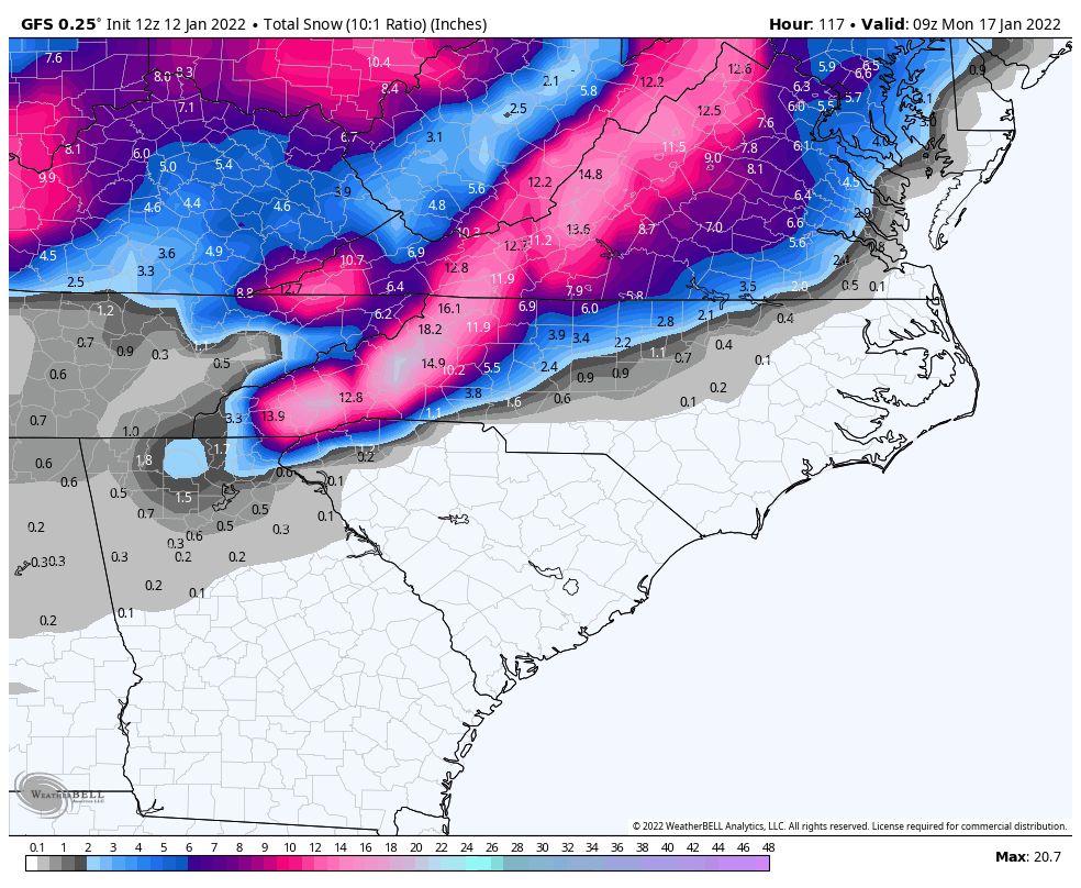
The snow map for the 12z GFS run is going be pretty stout.
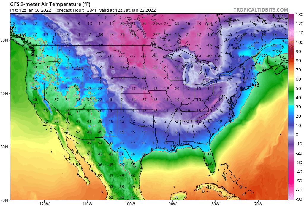
That has got to be my favorite all time fantasy op run. Even at 384 hr there is a nice artic intrusion fixing to bomb down out of the Dakota's.
-
5
-
-
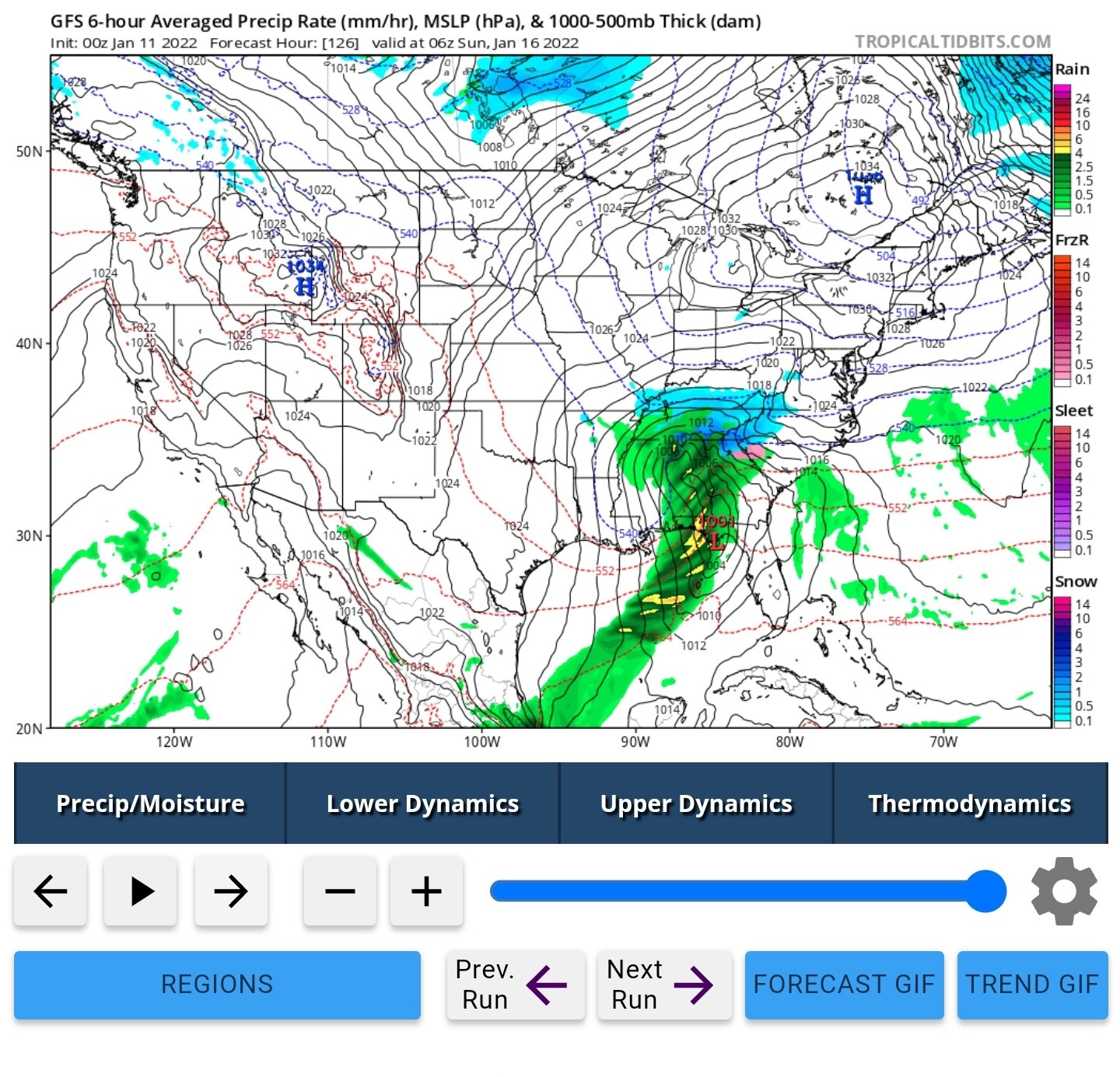
Not that it matters, there are a billion threats and billion changes to come, but in the long term 12z gfs there is the world's greatest clipper dropping down at 300 hrs with solid precip falling into 7-15 degree air for a few days.
-
3
-
-
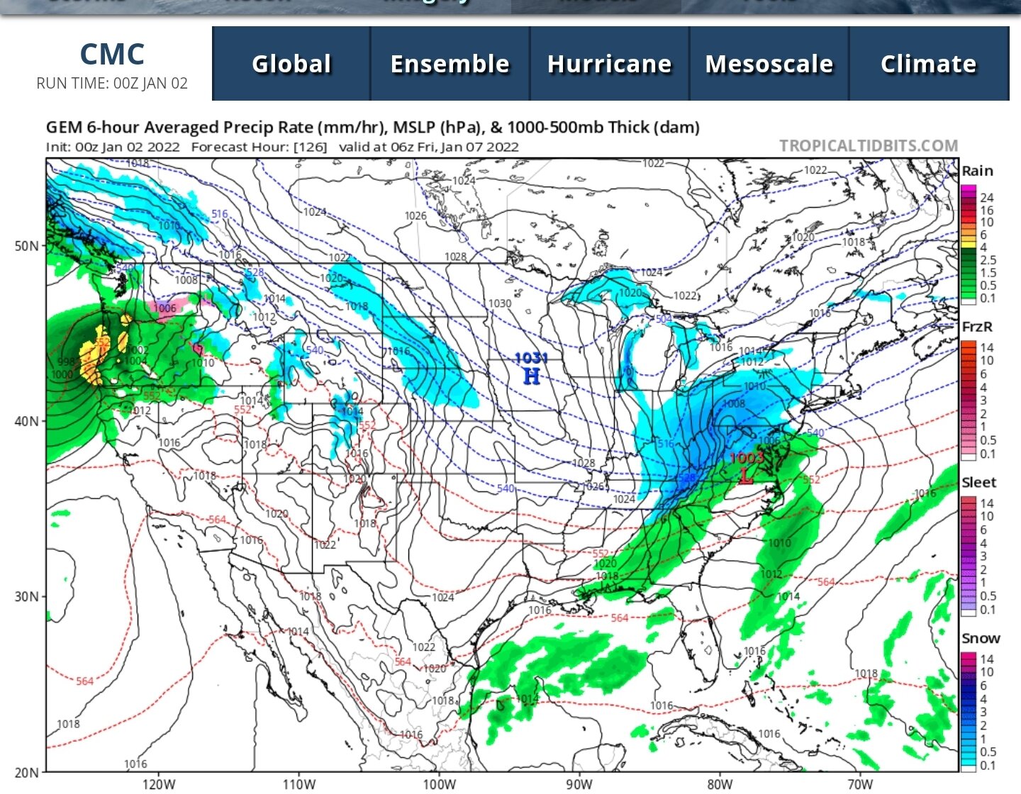
Nearly a perfect track for east Tennessee on 12z CMC, wish it turn a little sharper west at hour 126 but that's nit picking.
-
1
-
-
31 minutes ago, Carvers Gap said:
We need this to really dig or this is going to easily be a Carolina special. I remember some storms like this back in either the late 90s or early 2000s where the snow line stopped right at the top of the Apps. I had to go to Carvers Gap to see snow!!! LOL.
My post really adds nothing of substance here but whenever I see Carolina getting crushed I always feel fring-y at TRI. It's happened alot over my lifetime, enough so that I will have a bad knee jerk reaction when I see the bright colors over NC lol.
-
2
-
-
-
Brick is on pace to be the next Bob Chill, beloved man of the forum.
-
12z cmc and gfs really locked on to the next 6-7 days, remarkable jump.
-
3
-
-
27 minutes ago, NorthArlington101 said:
my biggest failure as a snow lover is that I cant ski. I just have zero body control -- literally can't figure out how to lean from one side to another to turn and I've got duck feet so the pizza/french fry thing fails.
Was just discussing this with a beginner friend, the pizza aint supposed to save you down steep terrain. I made the biggest jump in sking when I learned to move horizontal down steep stuff, side by side through pressure, which is ultimately the only braking that really saves you if that's your big fear (was my hurdle). Alot follows from that.
-
And for east tn/swva we've lost the mid to late week clipper action on the 12z suites of the CMC and GFS.
-
 2
2
-
-
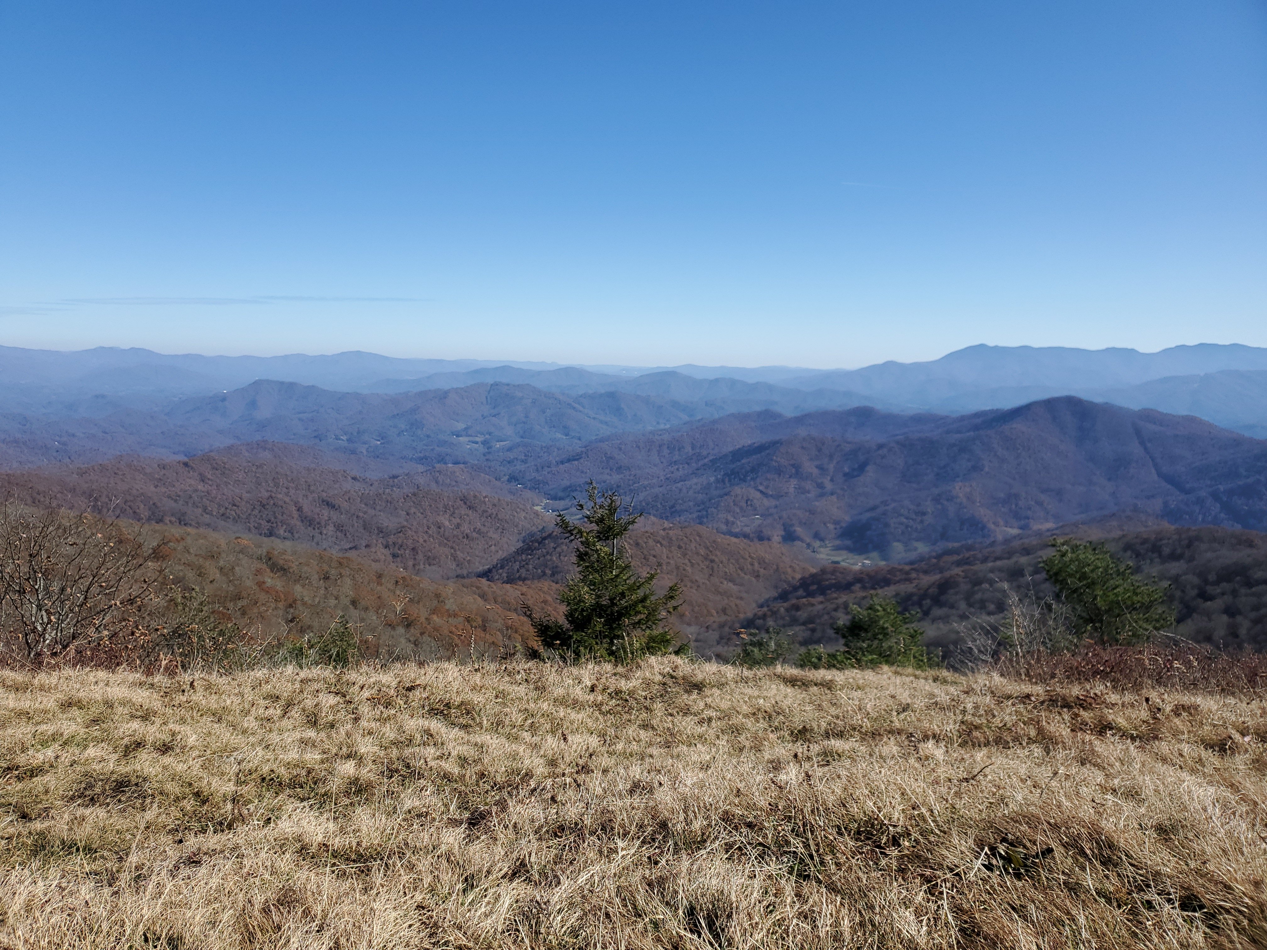
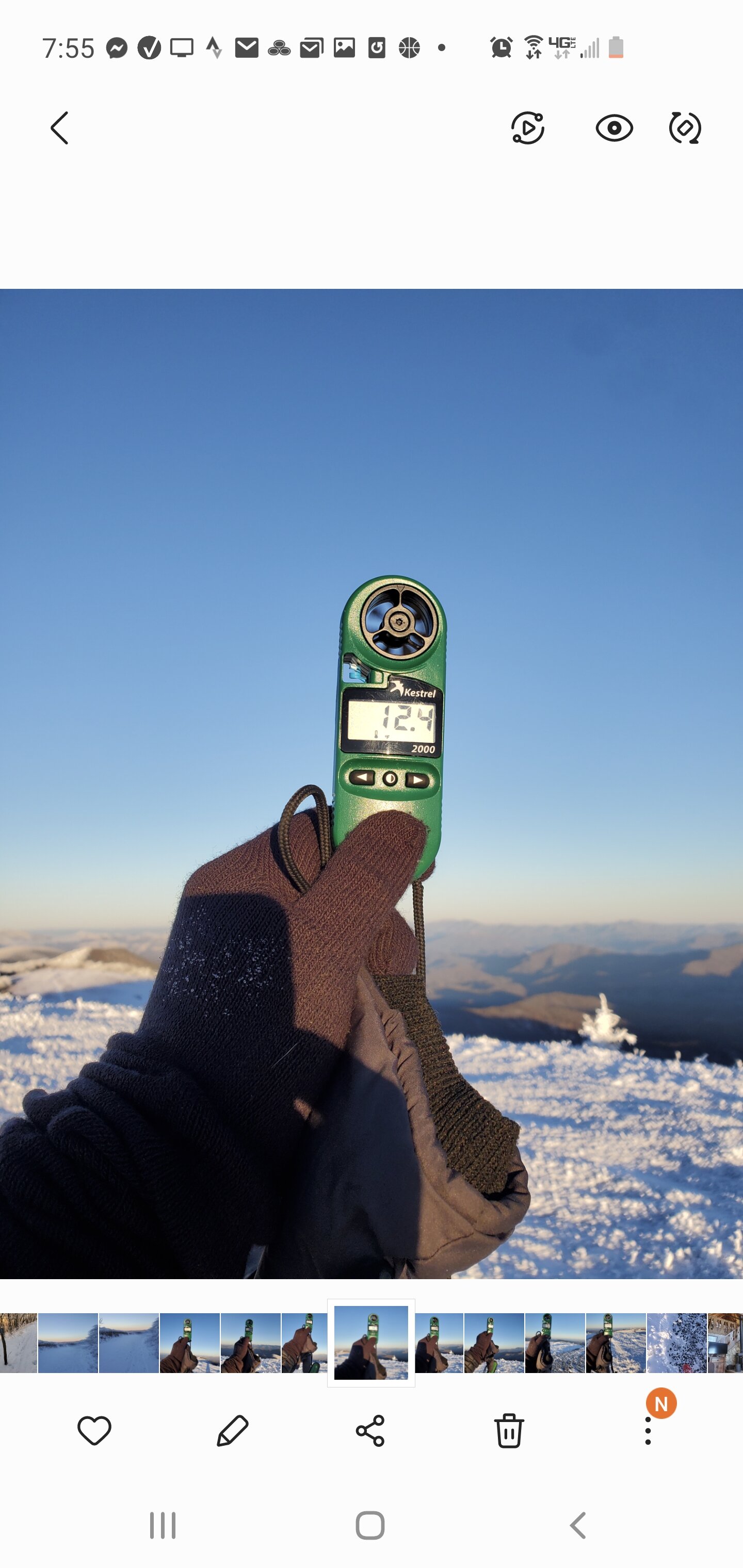
Tried to get a time lapse of the sunset atop Big Bald today and I couldn't take the cold long enough to do it. Basically, sweating while running up to the top got me, was 3.7 up 3.7 down. My kessler pocket temp reader said it was between 9-13 degrees, with winds steady at 5-10 gusting into the 20 mph range. I would think subzero is possible later.

-
3
-
-
41 minutes ago, Holston_River_Rambler said:
That's ideal.

Hard to beat a good cold snow/high ratio, definitely at the top of the pantheon here. A big bucket lister is to get to enjoy a 2-3 day northwest flow event somewhere in a cabin in the high mountains.
-
3
-
 1
1
-
-
9 minutes ago, Daniel Boone said:
I've always said that 100. I recall back in the '90's Dierks on WCYB saying their avg seasonal snowfall was over 100 inches.
Really, it would also fill the void between Western NC to Snowshoe, WV. Add to that, super easy access off the highway there. Would of been interesting seeing a high fleutan Norton!
-
1
-
-
Just now, Carvers Gap said:
Yeah, they are money up there. If we had to name a snow capital for the forum area, it would be in my top two. Sits at 2,400' and has a latitude advantage and gets lake effect snow to some extent on northwest flow. The snow totals they have for storms rivals some cities out West.
I wish they had built a ski resort near the top of the knob in the 1940s, how different would Norton look like if so! Max elevation at the top is...what? 4200' ? Ski down into the bottom with well over 1000 vertical drop (beech and sugar only drop 7-900 ft) would of been an epic setup. Norton looks great in snow
-
1
-
 1
1
-
-
15 minutes ago, 1234snow said:
Just to show the microclimates. 41 when I left Kingsport on the south side of Bays Mountain down to 32 when I got to the state line in Virginia. Snowing pretty solidly here in Weber City with the ground white.
I just came from wise, they were getting hammered up there. I am guessing they go 6 plus easy
-
2
-
-
Beautiful snow in wise county VA. I ll be leaving here on what is surely a depressing drive to kingsport.
-
1
-
-
Posterity sake for Carvers 384 dreamland:
Over the last week GFS has been hinting off and on with some major artic intrusions, at times its been really fun to watch.

-
2
-
-
3 minutes ago, Carvers Gap said:
I like that timeframe from the 15th onward(not that the one right now isn't producing). But watching the 12z GFS roll, there is room there for an Arctic outbreak.
Hey Carver, I was looking at the awesome 12 or 18z gfs from yesterday which had some frigid air intruding and staying around around the Jan 15th onward time-frame. Later runs, I think 0z, had shunted the cold in Canada toward the far eastern areas and eventually away. Was that eastern shunting the result of a lack of blocking in the Atlantic verse what is depicted on this run (the cold centered over middle canada)?
-
How cold is the 18z gfs long range? I am not sure ktri gets above freezing from 300 out to 384, and prolly beyond that if it went.
-
1
-
-
18z gfs mirror the rather meteoric run of the 12z. We can all dream!
-
1
-
-
What has been rock solid is Roan Mtn down the Smokies. I know they will always do better but it's been modeled solid there for a long time now.
-
Jan 7-9 period still looks good for a light event although the 0z gfs is less enthusiastic than the prior 18z run, but 0z CMC has a nice event unfolding similiar to the 18z gfs. I think Kentucky is the main winner on that run.

-
1
-

Jan 16-17th Boom or Bust
in Tennessee Valley
Posted
Normally that's a beautiful track for east Tennessee, low just south of mobile, alabama. I wish it would meander over to Appalachacola before turning north but it seems to work for I 40 north.