.jpg.949052775cf13715749e9bd3740a4bd3.jpg)
Bigbald
-
Posts
174 -
Joined
-
Last visited
Content Type
Profiles
Blogs
Forums
American Weather
Media Demo
Store
Gallery
Posts posted by Bigbald
-
-
Alot more easterly out to sea on the gfs. I thought we had settled that!

-
7 minutes ago, Hurricaneguy said:
I'm in Greeneville. I do not like seeing the cutoff right on our county. When it's been nearly two years since a decent snow that drives you crazy lol
Not sure I'd sweat it too hard. Rgem loses the flow for like a 6 hr panel at hour 67. It looks like an error to me since prior runs don't disconnect like that and it picks right back up at like hour 72ish. Would be a good hit for JC
-
 1
1
-
-
Toots Weather Forum was a good one for east TN snow homerism. Toot could hug a snowy model till the end. Toot was apparently a little abrasive in various weather communities and died tragically young.
-
3
-
-
I always enjoyed probability and statistics in college, even though I was horrible with numbers. If they think there is a 40% chance of 3 or more inches, would they also accept a 5000$ bet to pay out equivalent odds that it does snow over 3 inches?

-
4
-
-
12z was Johns "snap to" suite for the first wave. For east TN, we watch the second development to know if we go from very good to epic.
-
1
-
-
Fair to say the 12z suite RGEM, Canadian, GFS, Nam are in lockstep with orientation and axis of the first wave (?).

-
2
-
-
27 minutes ago, John1122 said:
That is the best run for a snow lover in Knoxville Tennessee, that I've ever seen on any model. Two events and 23 inch lollipops showing up in Knoxville over the 8 day or so period.
I cant think of a greater setup for a 10 day stretch of winter in my lifetime if this were to verify, when you factor the snow AND cold. All that snow would stay put for a long time. Lucky its a dry snow.
-
5
-
-
Oh my lawd, Canadian would be multiple 15 plus inches for east TN once adjusted for snow ratio
-
1
-
-
I'll count the CMC a win merely bc it's not OTS. Maybe we can end up splitting the difference, get that low back on the coast and moving northwest.
-
1
-
-
Wow, that GFS run might be the coldest 8-10 day stretch of weather I can remember seeing modeled for SWVA. We don't break freezing from Jan 13ish to beyond Jan 22ish
-
1 minute ago, John1122 said:
That was a big change by the GFS, going from a true Miller A to a frontal passage with a wave. Curious to see if the ensembles also abandon the miller A.
Wasn't it showing a stalled out front with waves riding 3-4 days ago, is this a return?
-
20 minutes ago, Carvers Gap said:
Sure. But...I would recommend staying out of the MA forum - LOL. Some of those cats(during the middle of snowstorm) start looking for the back edge of the snow. Some are great posters. The important thing to know is that there are good and bad Nino winters....the 90s have many of the Nino duds. As recent as 09-10 and 14-15, we have had decent ones. Will this be a 90s winter or a mid 2010s winter? We won't know until the end of February. There were many during the mid/late 90s who questioned whether winter would return.
MBY yard does better during either a weak La Nina or weak El Nino w/ a negative QBO. I take either state, but they have to be weak. If moderate or strong, then it doesn't tend to work.
Is this a strong El Nino? I haven't looked. If it is strong, that is a major East Coast warm signal. I thought it was moderate to weak. Seems like it is a crashing signal right now.
Really, we have seen two of the last three winters produce incredible winters for the western 2/3 of the forum areas. Two of those storms were active GOM storm tracks pushing into cold which seeped slowly from the eastern Plains. We saw Mammoth(not our forum area) get near record snows last winter as well as many places in the West. I still have bushes in my yard which are struggling from last December's cold shot.
It has been a while since we have had a snowless winter at TRI, but snowless winters are not without precedent(and they generally come in bunches). Those are the worst. I lived through multiple, snowless winters during the 90s. I think at one point, I hadn't seen measurable snow in like two or three years 96-97 to 98-99 were bad....way worse than anything of this past winter.
The record for this winter hasn't been completely written yet. If I hadn't seen a wx model, I would say it is about on track for a normal snow winter. There has been snow in the Smokies, and light snow in the northern valleys. Warm start -> flips around mid-winter...that is the climatology even if it is a good winter..
For now I like this timeline:
December 31-Jan10 - window for snow
Jan 15-25 - hostile to snow
Jan 28-Feb28 - good window for snow
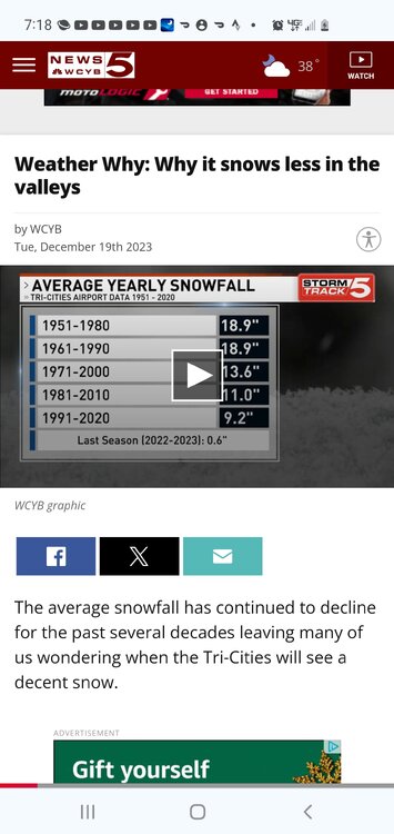
Carver, I am sure you have seen this graphic, wonder what the projection for 2001-2030 are at for ktri. 7 inches? We getting halved from 9.2?
-
1
-
-
Ski resorts, particularly Snowshoe, have one of the best looking early January forecasts I can remember.
-
4
-
-
49 minutes ago, Carvers Gap said:
I will say this, the system this weekend will help with drought conditions over E TN. The slp slows down and almost stalls.
My god what a storm track for east Tennessee on 18z. 4 days of solid snow, this easily could of been one for ages.
-
6
-
-
15 minutes ago, BornAgain13 said:
Well you know the GFS and Euro will not be in agreement... the last storm the Euro was showing snow here and the gfs was showing the storm further west with rain here. Guess what? Gfs scored the coup. Will see what happens with this one
Sent from my SM-N981U using Tapatalk
You would have to be a mad man to bet against a cutter this year
-
1
-
 2
2
-
-
19 minutes ago, Daniel Boone said:
Yeah, it's just ridiculous. Parts of the area may not reach Atlanta Climo. I'm still in hopes enough comes together end month first March to save it from being least snowy on record here.
In the broader context of warming temperatures I hope this isn't a foreshadowing of what typical winters will begin to look like. We aren't even close to an event here in northeast TN, and we really haven't had anything to track all winter. I can recall alot of crappy winters having a lot of trackable events that didn't pan out for one of the billion variables, but we still had things to follow.
-
4
-
-
2 hours ago, BlunderStorm said:

Russell county VA about 40 mins up route 19 from Abingdon or an hour NW of Gate City. Just up the Clinch.

A sign of the times when 1 inch slush/melt snow here in Wise ellicits all kinds of phone calls this morning. Pretty bleak compared to what we used to routinely get up here.
-
2
-
 1
1
-
-
When do we get to trend from a moderate snow depiction to greater and greater amounts? Why must it always be the opposite.
-
1
-
-
I was afraid the Cutter parade might return from last night's 0z gfs run.
-
2
-
-
Should of been more honking for this event given how cold conditions are.
-
4
-
-
1 hour ago, Carvers Gap said:
The global ensembles overnight are singing the same song....The Hudson Bay block sags a bit too far south to help at all. At 0z and 6z, I don't see any remarkable cool downs. Again, normal temps will get it done, and it may be a struggle to get those. All of that said, we are ten days from January....LONG way to go.
Carver, what time intervals are "normal" temps generated from? What is the start date for historical data?
If one moves that arbitrary start date to the year 2000, what is our normal temp at ktri? If you have a source I'll go to it and find the info myself. Thanks
-
1
-
-
Will be some nail biting for Michigan, Indiana. But they are in play for a whopper of a storm.
-
2
-
-
7 minutes ago, Vol4Life said:
Not seeing the western jog. Looks East to me
Sorry had the 18z in toggle. It is east of 18z.
-
2
-
-
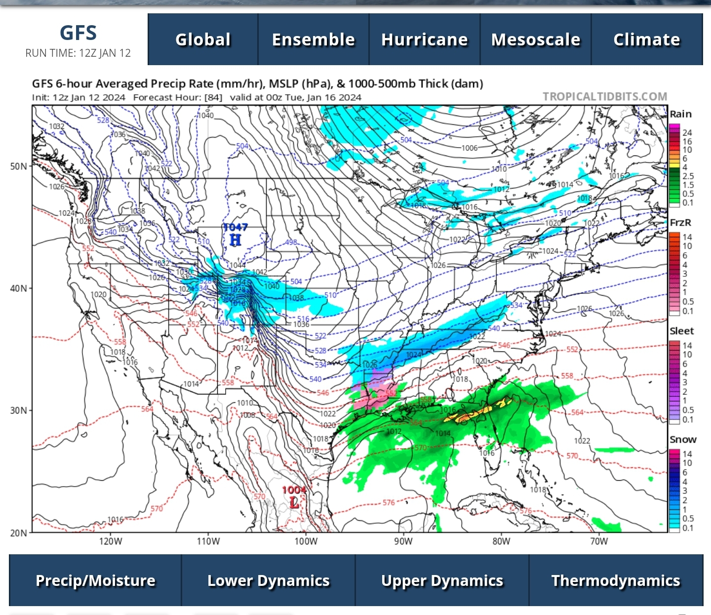
GfS is a western jog as expected. Given the fact we have 5 days left about the only place I'd be feeling good about is western Illinois/mizzou.
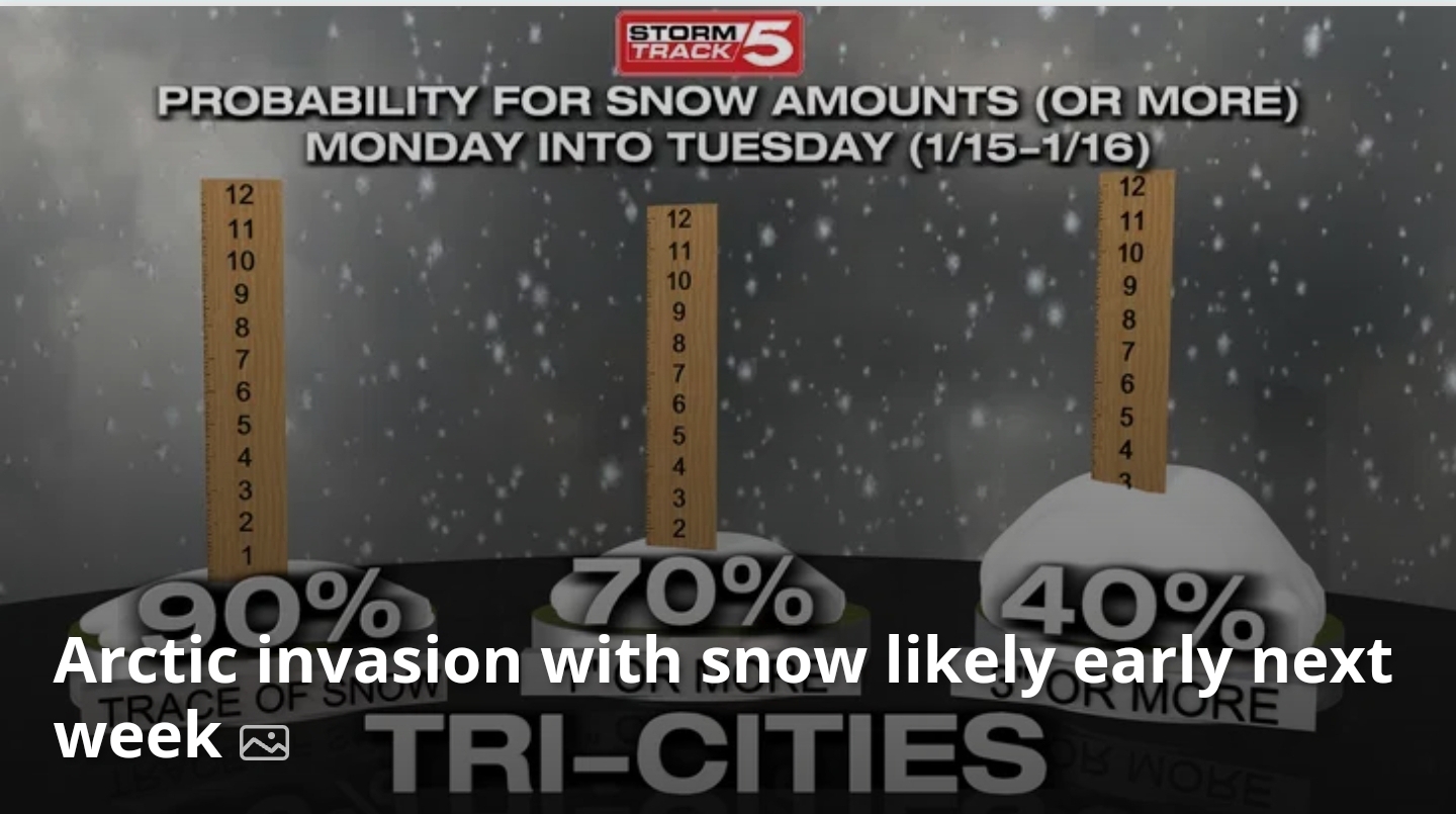
January 15th-17th 2024 Arctic Blast/Snow Event
in Tennessee Valley
Posted
Alot less qpf over a greater area and a southern sag, and a much less northwest trajectory. Really kind of dramatic between 0z and 12z considering the small amount of time.