.jpg.949052775cf13715749e9bd3740a4bd3.jpg)
Bigbald
-
Posts
174 -
Joined
-
Last visited
Content Type
Profiles
Blogs
Forums
American Weather
Media Demo
Store
Gallery
Posts posted by Bigbald
-
-
Should be some high ratio northwest flow at the very end for northeast tn/sw va.
-
 8
8
-
-
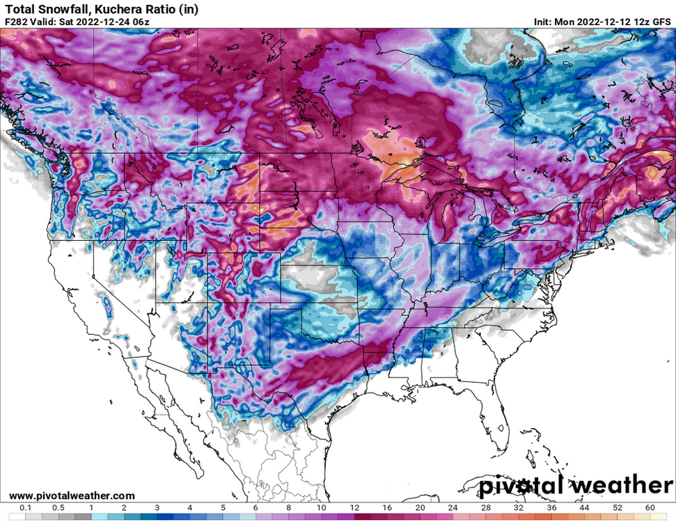
Man that Canadian run

-
5
-
-
Where oh where have we seen this axis before??? Seems like the last 2 years have had this kind of banking axis against the Apps. In lala land so its probably moot but I was just struck by the familiarity.
-
7
-
-
13 minutes ago, Silas Lang said:
NAM seems to be showing less precip and looking weaker.
2-3 inches over 8 hours is not enough to lay down and overcome ground temps with low rates for ktri. I would love to make a trip to gatlinburg however
-
Going to be tough looking at brown ground at ktri (once again) but probably a fitting end to a bad winter imby.
-
CMC 0/12z looks really consistent with a storm that doesn't materialize until basically out to sea, gfs 12z looks similiar. This has been a familiar pattern for what seems like the last 30 days, progressive flow easterly development.
-
2
-
 1
1
-
-
4 minutes ago, Holston_River_Rambler said:
12z GFS almost went BOOM with our Valentine's day chance:
We might set a record for how times we can whiff easterly this year.
-
3
-
-
One definitely can't call the 12z runs boring, alot of activity even if we aren't showing up as perfect hits on every storm.
-
1
-
-
It seems like in the last 3 weeks models have shown alot of perfect inland tracks for for the Tennessee Valley in the 7-10 day range only to have the system development much later and further east in the 4-7 day range. What are the players on the field that suggest we've bucked that trend?
-
12z gfs is a cutter parade until hr 320, ya know, the sweet spot of all modeling, which blanks west tn but hammers the east. Of course this will be gone by 18z.
-
1
-
-
9 minutes ago, Silas Lang said:
Annddd the 0z GFS takes a step back from the 18z.
Not a great run for anyone except far Northern New england.
-
4 minutes ago, Silas Lang said:
Does anyone think a NW trend becoming any more likely at this point? Or is the energy still highly volatile? Feels like it has been hard to get a real trend run to run so I am still leaning on the latter at this point.
The track looked pretty similiar to me aside from the fact it gets more amped earlier, the ramifications which seems to expand the precip shield and change the track more inland for the folks in the middle Atlantic. I can't get myself excited here but I'll watch it all the way like everyone else.
-
2
-
-
6 minutes ago, Carvers Gap said:
Here is what is odd...If this was a rogue run, that is now three rogue runs out of the last nine. Seems like an off-run would not be repeated without some support at some level. It is worth noting as well that this type of solution isn’t just showing up on the GFS. We are seeing this setup across modeling along with hit or miss big runs. I tend to think models might be honing-in on a big storm. The 12z Euro had a nice storm right after the one the GFS has had. The ingredients are there for a big storm. Whether it happens, no idea. Obviously, nothing is a certainty at this range.
That, and the fact that all 3 models jumped on that one 12z run from friday. I kind of wondered if models were latching on to the big dog that sometimes happens far out.
-
1
-
-
10 minutes ago, nrgjeff said:
Auburn got it done on CBS! Did they get in? Camping out for basketball takes me back to college, and some cold days in Lawrence, Kansas.
And since UT Chatt didn't cover the spread, I'll double down on Kansas. Not necessarily responsible gaming, but it seems like the thing to do, ha.
LSU at Tennessee should be another barn burner. Great to see all this excellent basketball across the SEC!
Two thing I say to myself every saturday:
1) how is will wade still coaching after the fbi tapes?
2) how is Bruce Pearl still coaching aftrr the Chuck Persons scandal?
-
1
-
-
Yeah this 12z gfs run is going to be a beaut and front loaded (under 250 hrs).
-
What an awful 12z suite for friday/Saturday ha. At least we were never really in the game to be too invested in this system. Some of the model runs showing the precipitation shield blossoming west always looked funny to me anyways. Will still watch but I guess we are in punt territory.
-
50 minutes ago, Carvers Gap said:
That almost looks like the same run with the exception of the 12z from yesterday having thermal issues which it shouldn't. Just have to think this jogs west during the next few days of modeling. Interestingly, the UK wasn't completely wrong with the last system, but it did miss the middle TN snows.
Jeff's post above is interesting. Both model biases in play....GFS with a progressive nature for SLPs which take the low road, and the Euro which could be missing finer details.
Will just watch trends during the next couple of days. It would seem unlikely that modeling would hold that position for the next five days as the last three storms(even they system Holston shows with his trend gif) have trended well northwest during the final 5-6 days of modeling. It seems like the NW trend halted overnight. It is highly likely that the system rides the front which comes through TR night. I would suspect that front doesn't press as far as originally modeled. Again, something that has occurred for 2-3 seasons in a row. But who knows....interesting look and certainly one to keep an eye on during the next couple of days.
Do we need that front to either move through quicker, or hang up more? I noticed in some of model runs from the last 4-5 days ago that when the front was originally pushing through it allowed a better track. Further watching would show it sometimes getting "entangled" with the frontal passage but well to our SE and getting pulled that direction?
-
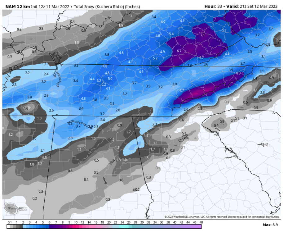
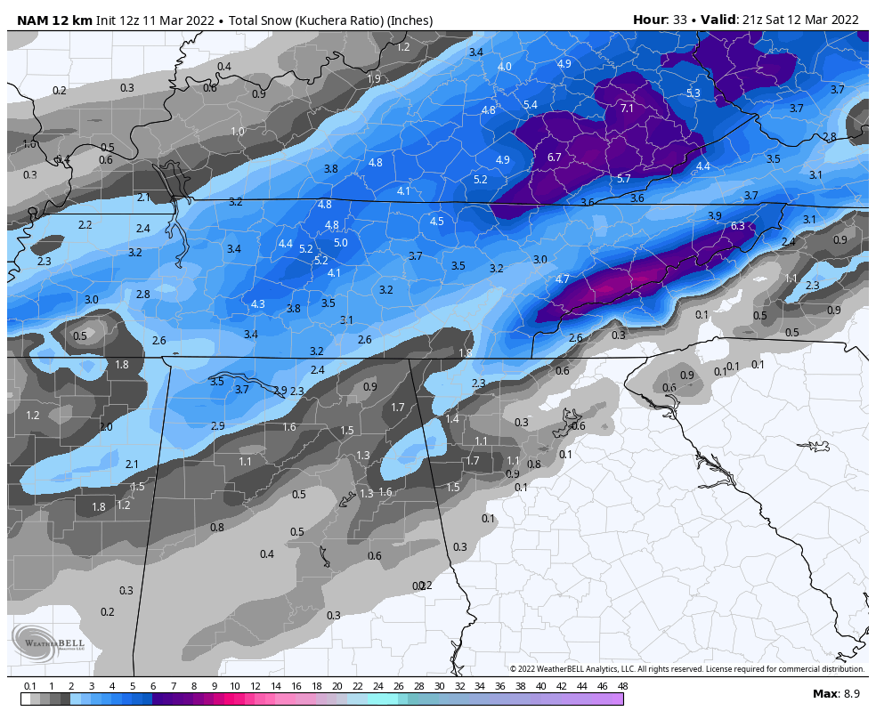
Nam 12k and 3k try and keep the NW flow stuff around for upper East tn/swva until Tuesday at 2ish. Roan mtn must be a total mess!
-
3
-
-
9 minutes ago, Holston_River_Rambler said:
6z Euro had the wave "riding the front" snow over SE KY and SW VA that I think we've seen on most of the recent model runs, but it also tried to build another wave back over MS toward the end:
I don't know what I think about this weekend system. Do y'all think this is a typical situation where we can expect a NW trend? If that's the case I like where we are at this range.
Bob Chill had a good synopsis in the MA forum as to why they could fail in a seemingly perfect pattern because of how progressive the flow is. I believe it could apply to us as well or anyone a little further inland.
-
2
-
-
9 minutes ago, Potvinsux said:
At least 5-6". Heaviest it's been all day.
Is that Alleghany Springs?
-
Starting to get run to run consistency with the cold that follows, boy it turns cold and stays cold again on the CMC and GFS.
-
2
-
-
14 minutes ago, Matthew70 said:
I hope it’s not cold & dry for middle TN but it sure looks that way. Par for course unfortunately.
Per what model run? What deterministic measure are you using?
-
6z gfs suppresses most the storm action but my god it's cold. Ktri basically stays below freezing from around hr 110 till near the 384 hr mark.
-
11 minutes ago, Brick Tamland said:
So the Euro, GFS, and CMC all had the storm for the same time and similar totals, and now they have it to the south. Seen this before and in the past it ended up trending NW.
0z CMC well northwest of 12z
-
 2
2
-

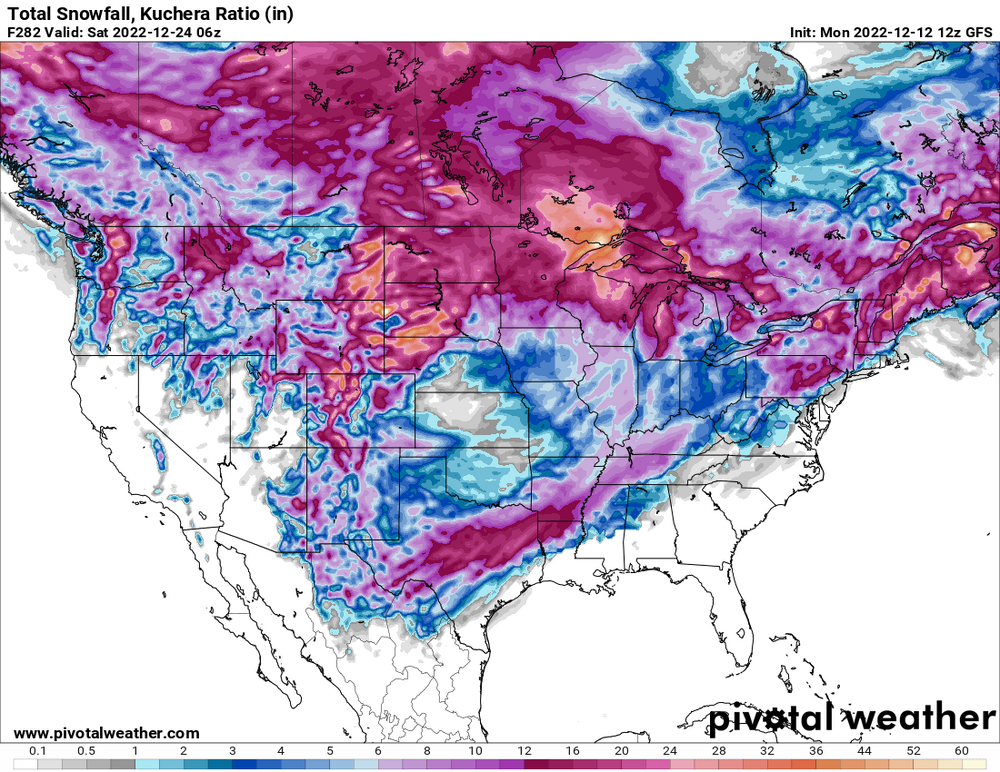
Historic Christmas Cold & maybe snow?! Dec 23rd-30th
in Tennessee Valley
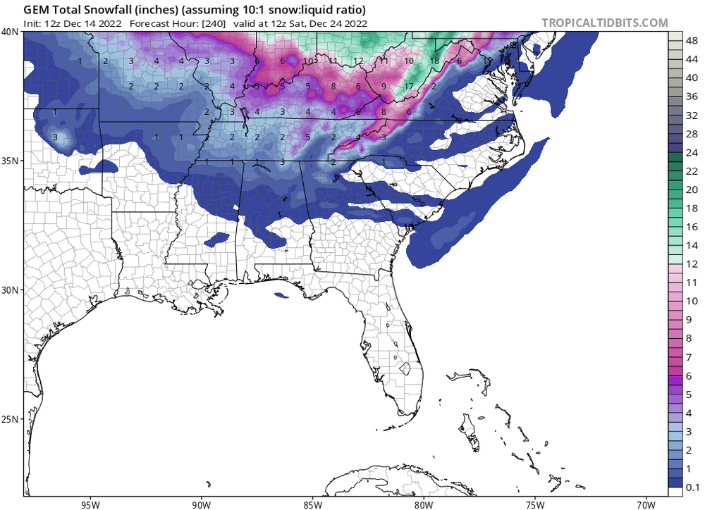
Posted
12z Euro: this is the way to kickoff the winter tracking season with sheer disapointment, eases the sting and sets (resets) a low expectation for all of the 2023 season...merry festivus everyone