.jpg.949052775cf13715749e9bd3740a4bd3.jpg)
Bigbald
-
Posts
174 -
Joined
-
Last visited
Content Type
Profiles
Blogs
Forums
American Weather
Media Demo
Store
Gallery
Posts posted by Bigbald
-
-
5 minutes ago, ShawnEastTN said:
0z NAM non kuchera:

Sent from my SM-G965U using Tapatalk
And that's with the quad state ripper:
-
 1
1
-
-
3 hours ago, Bigbald said:
I feel like there is some support for it, 12z Euro has the storm, I think the last few icon runs has as well, most modeling has shown it off and on the last 3-4 days. I think Candadian jumped on it first. Let's see if it moves toward run to run consistency but I like it.
18z GFS picks up storm, similiar positioning as others, brings in the bitter cold after it but not as deep as CMC. Great agreement amongst the models sans the finer details.
-
5
-
-
3 minutes ago, TellicoWx said:
Under normal circumstances, yeah most of the time. But this is the most unusual storm I've followed in a long time.
At this point it's kinda like "what could it hurt!?" Ha
-
1
-
-
1 minute ago, TellicoWx said:
18z HRRR @33

Damn, I am excited for you guys in eastern middle TN. Wow
-
2
-
 1
1
-
-
42 minutes ago, Icy Hot said:
But it's the CMC...
I feel like there is some support for it, 12z Euro has the storm, I think the last few icon runs has as well, most modeling has shown it off and on the last 3-4 days. I think Candadian jumped on it first. Let's see if it moves toward run to run consistency but I like it.
-
1
-
-
The period of next weekend continues to look intriguing. 12z CMC drops a 1050 high out of Montana and suppresses a storm just to our south, although Chattanooga would get scraped. Prior 12z cmc run had this compromise I think, although the storm was more modest.
After that it's pipe bursting cold. Suppose the high is a little weaker and the cold front a little slower it would be a great setup for alot of us, from my novice eyes (paging Carver).
Edit to add: could Miami really get that cold?

-
2
-
-
0zGfs track looks just like WPC forecast. We may have removed one hiccup from the equation if this is a new shift
-
Rgem gonna save us all.
40 hr wintry event lol. Let's hope it's consistency is telling.
-
2
-
-
-
11 minutes ago, Carvers Gap said:
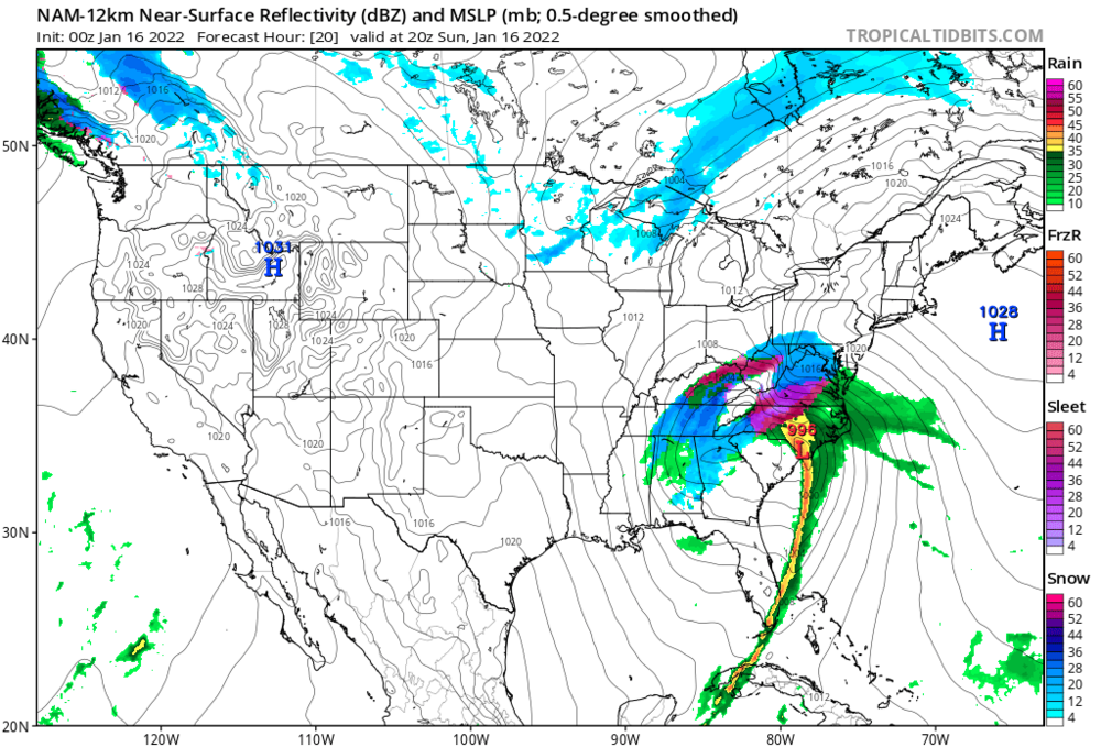
Right now, if the 0z NAM is correct, I am not even sure I get very much precip of any kind. Been this way all summer and fall and early winter. There are places in TRI where they get nothing more than a passing shower with this system. La Nina is just dry here for many systems. Doubt that verifies, but who knows! LOL. The downslope issue looks way overdone to me. Wonder if there is a feedback error there. We will certainly deal with it, but not sure I have ever seen a storm look like the NAM and HRRR have it. Very similar to last winter where the cold/snow stayed west of the Plateau. That said, I think that changes after the 20th.
That damn rip that starts in the great valley is like a tear in the time-space continuum. I don't even think Snowshoe would see precip, it's almost like an eyewall in a hurricane. What will keep me watching till the bitter end is my disbelief that the storm track is right up the Apps.
-
3
-
-
18z Rgem looked good again. It's holding consistent.
-
1
-
-
5 hours ago, TellicoWx said:
That is what is messing up the 850..needs more separation or the valley is left on the outside looking in
How does the RGEM resolve this issue?
-
6 hours ago, Carvers Gap said:
So, what we rally want to see in the eastern valley is a suppressed storm track, but just faint enough that the track still lifts the system northward. Looks to me like Jan20-30th is the best shot(maybe the last shot?) this winter for the eastern valley. February is not set in stone at this point by any means. However, in terms of having deep cold available, this is likely the last time frame where we can tap winter time cold. Could the track be too suppressed? Sure. But the track has never really been so suppressed this year to the point systems have skirted completely below us in the east. Systems have trended back northwest all winter. So, that window looks good. Plenty of energy. I suspect, as the 6z GFS depicts, that the timeframe will be active and cold. After that a period of moderation or pattern change. Looks like another great winter or folks in the middle and western parts of the forum area. They were well past due for a good stretch. Very traditional storm track for La Ninas, and a good reminder that warm Decembers don't always equate to the rest of winter being warm.
There is so much going on in that jan 20-28 range that it is hard to keep up. This has been an awesome 12z suite.
-
5
-
-
Dang that's a pretty looking run for western NC mountains.
To rehash 12z, it's basically a UKIE, CMC, RGEM battle against euro, gfs, nam ? Would this be roughly correct?
-
2
-
-
1 minute ago, VOLtage said:
Latest GFS and NAM both show a hole in the snow that pretty much blanks Blount county.
We can't even pin down the exact track of the storm so I wouldn't be too crushed about snow holes just yet
-
5
-
-
That was a very sexy 12z Canadian run out through 240 with some major cold coming at the end. Just a super active pattern with multiple threats and cold.
-
6
-
-
9 minutes ago, Matthew70 said:
At this rate the euro is last remaining hope. Which lately it’s not been so king. Sunny & cool weekend I can handle.
Is it really though? CMC was a good hit and track for east tn, and so was its short range model. Still plenty of time for this to trend good.
-
Alot of the runs 48 hr ago had a nice clean miller A look for at least a few suites. Hopefully we are returning to this look (?)
-
1
-
-
What is pulling the low up and almost straight vertical due north from lower exteeme southeast alabama? If we could get rid of that wiggle most of us in East tn would be in great shape.
-
1
-
-
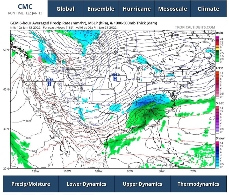
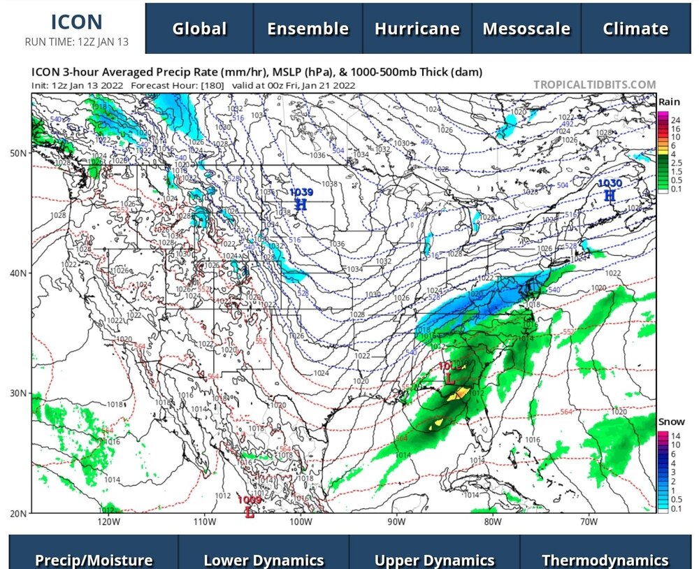
Late next week looks interesting. 12Z ICON and 12 CMC (see images below) both have a solid setup, 12z gfs is there but less robust.
-
1
-
-
I feel like this is groundhog day for how many ways we can attempt to eff the great Valley? Wow I would I've guessed we were golden with that low placement off Franklin County, Florida.
-
1
-
-
This is normally a great look for Tennessee snow.

-
8
-
-
13 minutes ago, Daniel Boone said:
Yeah, if it doesn't trend away from that it sure is not looking good for the great Valley. Need that shift back south and east.
At ktri I havent been able to get myself too high for this for all the freaking reasons you mention, man we are really up against the big 3 here (dry slot, downslope, warm nose), anyone of which could wreck us.
-
1
-
-
Debating on chasing this one to Boone, NC. Alot of hand ringing about the prospect of seeing a 24 plus inch snow, which is probably a once in a decade type snow, but also about the prospect of being able to drive back to K-TRI for work next Tuesday or so. Dilema!
-
1
-


.jpeg.2feabfcf47ae2a8965e230fdb6e448df.jpeg)


Winter 2021/2022 January Thread
in Tennessee Valley
Posted
Nice little NW jog, hopefully not too many more of these.