

BxSnowWx37
-
Posts
229 -
Joined
-
Last visited
Content Type
Profiles
Blogs
Forums
American Weather
Media Demo
Store
Gallery
Everything posted by BxSnowWx37
-
I dont think models are handling the power from the cold coming itself,if the low is maturing riding up to the bm then it's gonna snow hard in nyc. Let's not forget the extreme precip rates with colliding airmasses, it might be a case of western areas getting their 6+..coastal areas catching up and passing their totals due to the enhanced precip shield. Things to look for folks..
-
Every classroom needs a class clown,snowman is him.
-
Looks gd. I'd take 4 to 6 in this setup..
-
Snowman never roots for snow when even his name sez it!!..the ultimate oxymoron!!
-
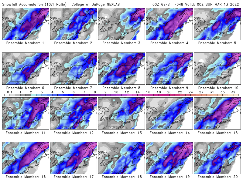
I'd say..the ensembles look juicy surprisingly for nyc. And that's more then 50% of them..
-
It's gonna snow to the coastal plain,just how much falls is the??
-
Interesting times ahead. I've been on the side of heavy rain to heavy snow for 3 days now. It's gd to see it keep inching closer to that snowy solution..
-
Everything is a white paste coat up here..still all snow. We def got more then a inch here even with the melting and compaction..
-
And here comes the heavy snow once again..these bands are really gonna whip nyc and l.i for a while. The best lift is prob right over us rn as the upper level low to our west approaches and jumps to the coast.
-
The upper level low is transferring to the coast,we are gonna get rocked if that band doesn't move much while it interacts with the new low off the coast.
-
We should be getting some gd returns popping back up around here. The upper low is transferring to the coast and all the echos building to our south and west are coming this way and filling in..
-
No kidding everything is pretty white here too. And coming down hard..its almost noon and it's quite a event if you can see heavy snow in daytime and it sticks.
-
Literally this might be the hardest snowfall all of winter. You can see the accumulation in real time literally by checking every 5 mins,that's how hard it's snowing here.
-
One thing is for certain that northerly wind is driving the cold down. We couldn't get a mangled flake with a se wind earlier.
-
It's snowing hard rn,flakes look like mini snowballs falling. Starting to stick to colder surfaces as well.
-
Interesting to see the sky turn darker,it was a rain sky earlier and much brighter..now its def now a snow sky and a much darker grey. 34f with snow now falling here in the northern bx..
-
Winds are changing direction so the easterly component is now northerly. Trying to bring in some cooler air which is prob why it's now snowing in parts of the city.
-
Snowing in the bronx rn..nice fluffy wet flakes. The eadar shows rain but its def snowing pretty gd up here now..also some heavier stuff is incoming.
-
Yeah most models have us from mod to heavy rain to mod to heavy snow for a while. Depends on how fast the cold can rush in behind. We need the low to keep creeping east,which is seems to be doing.
-
While we await a couple of inches snow with this one,the next storm creeps east every run. Nyc might see heavy rain to heavy snow for a period with the way things are looking. Still some time to keep adjusting east.
-
I mentioned how the cold wasn't going anywhere yesterday. The whole event for me was under 32f. Everything is still iced up..tonight is gonna be an adventure when it really freezes up with blk ice.
-
Thos is prob why our winds are NOT off ocean anymore. A new low has popped up south of all guidance. Originally it was supposed to be just south of l.i as the transfer occurs.
-
It's now sleet/zr and mangled flakes now falling here. The upper levels are trying to cool off a bit it seems esp with the heavy stuff coming in.
-
It's a pingerfest rn ..and it's cold..heavy precip is also incoming in to nyc.
-
Tbh it's prob gonna trend a bit cooler. Even for nyc,it looks more then a inch of snow esp if it's moving fast. Also on almost every model 950's temps never go above freezing,esp for westchester county and the bronx,Northern Manhattan.


