.jpg.7212c88cd7a6ee918250d4a9d2a8d183.jpg)

Chicago916
-
Posts
176 -
Joined
-
Last visited
Content Type
Profiles
Blogs
Forums
American Weather
Media Demo
Store
Gallery
Posts posted by Chicago916
-
-
At hour 54 on the GFS it looks like it's now seeing some stronger energy in NM that looked to be on the GEM and Euro all along.
-
Not sure if they do them since the pandemic, but with the holiday travel next week, would the NOAA try to add extra aircraft sampling for this storm?
-
Insane pressure drop on that run. Sheesh. No matter where this thing goes, going to see some dangerous wind-chills on the backside.
-
The NAM is gonna break this site once in range
-
 2
2
-
 5
5
-
-
Just now, Chicago Storm said:
they have always been pretty bad.
When they were riding the GFS the past few days despite 0 continuity was comical too
-
Might be the wrong place for this banter, but lmao at BAM weather so deadset on an easterly track of the storm. I guess we'll know soon enough, just find it funny.
-
Just now, A-L-E-K said:
Good runs
No rain GIFs after seeing a couple GEFS members showing rain?
-
Looks like the past consecutive 5 GFS op runs have slowly shifted west towards the Euro...
-
 1
1
-
-
GEFS showing quite a few cutters that would make everyone happy. Why even pay attention to the OP runs at this range?
-
1
-
-
If it's any consolation if the Christmas week storm ends up on the east coast, could see a decent lake effect chance on the Chicago side of the lake?
-
2 hours ago, A-L-E-K said:
time 2 ride
I'll take the 15Z Rap and the Kool-aid it's sipping. Nevertheless, looking more likely that it'll at least thump for a little bit.
-
1
-
-
Tons of small hail in Avondale with strong winds
-
Went from nada to heavy pixie dust near the Metro just now.
-
Just now, Chicago Storm said:
bump. the time has come.Great time to begin haha
-
Purely anecdotal too (didn't look into the moving parts), I don't think the Ukie ever really showed an amped solution with GHDIII ever, so nice to see at least a run with that solution during the 0z run.
-
Those radar returns entering Cook and Dupage look juicy
-
1 minute ago, homedis said:
I’m kinda on the border of Logan Square/Bucktown/Wicker Park (I just say Wicker Park because its the most identifiable). Near Armitage and Milwaukee. Hbu?I'm near ya too! I'm in Avondale myself.
-
1
-
-
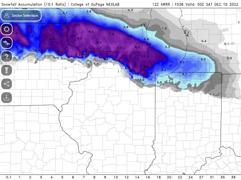
Someone show the maximum snowfall amount at the end of the HRRR for everyone
-
51 minutes ago, Hoosier said:
Do you have any thoughts on the lake enhancement potential in the area? I don't want to say the parameters are God awful the whole time, but... lol
Inversion height get pretty shallow at times, like 4k feet with considerable drying just above. Sufficient delta T up to that level though. Seems like the most aggressive guidance may be overdone. Thoughts?
late run 18z HRRR joins the rest of the models in this big time
-
How's the HRW FV3 model been? I'm assuming not good with winter events? The weenie in me is binning it with other higher resolution models that are shifting North.
-
I could so envision a scenario where Cook gets to 10" plus by getting lucky with the frotogenetic band and then additional lake effect/enhancement while the main storm passes Southeast.
-
Just now, Chicago Storm said:
There's one member with 33" at ORD still. So bad.
I saw that haha. I'd love to see that individual member
-
Just now, Thundersnow12 said:
HRRR is NW with first round through 30hrs
And SREF is also still NW. Grasping at straws lol
-
1
-
1
-
-
Just now, Hoosier said:
Could be anecdotal/bias but I feel like these tend to drift north more than south at the last minute.
I keep remembering this winter one of these forecast originally in NIL and it ended up in southern WI. Not 100% but pretty sure it happened.
Pre-Christmas (Dec 21-23rd) Winter Storm
in Lakes/Ohio Valley
Posted
Everytime I see the GFS or other models backing the low west over Lake Michigan it reminds me of mesolows, except we might be dealing with a sub 980 mb low. Oof.