.jpg.7212c88cd7a6ee918250d4a9d2a8d183.jpg)

Chicago916
-
Posts
176 -
Joined
-
Last visited
Content Type
Profiles
Blogs
Forums
American Weather
Media Demo
Store
Gallery
Posts posted by Chicago916
-
-
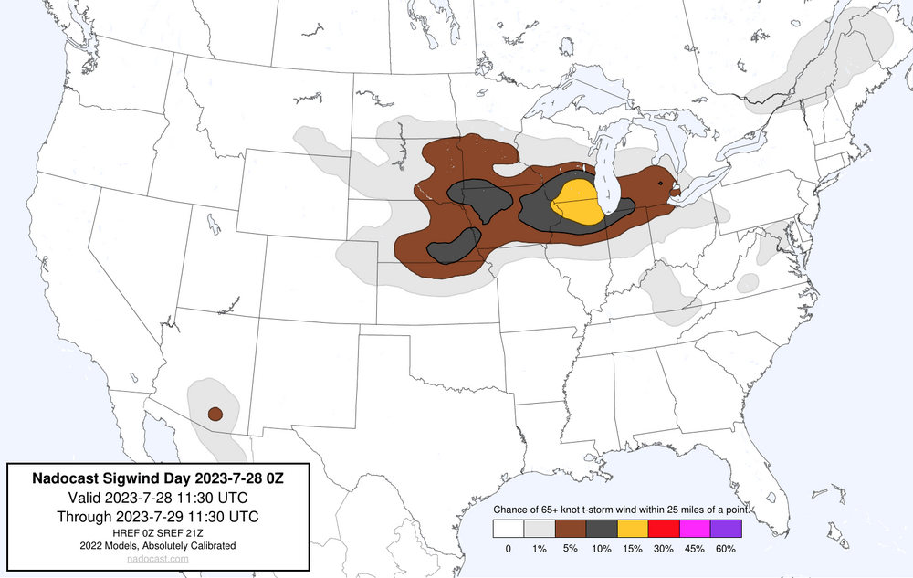
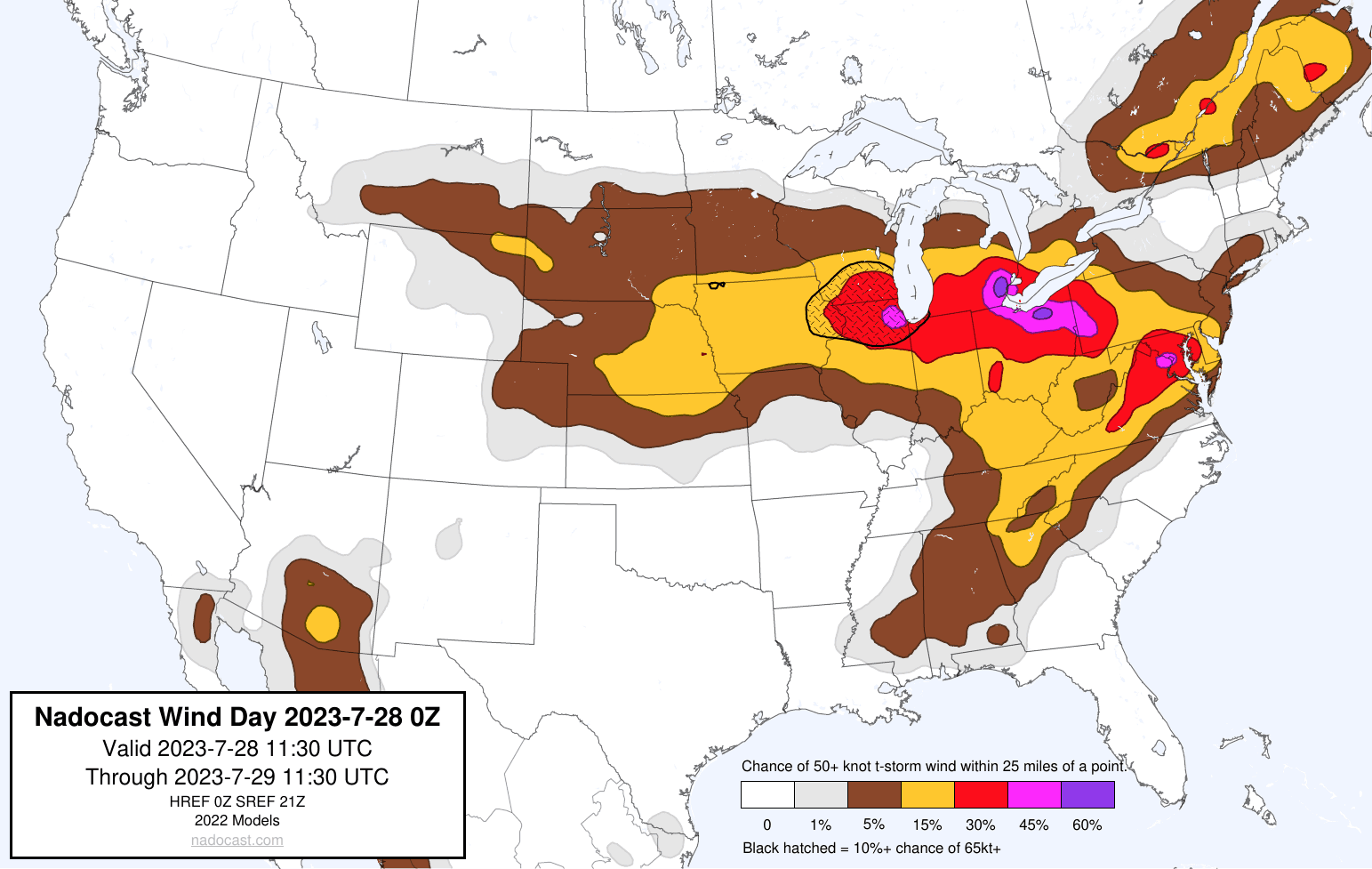
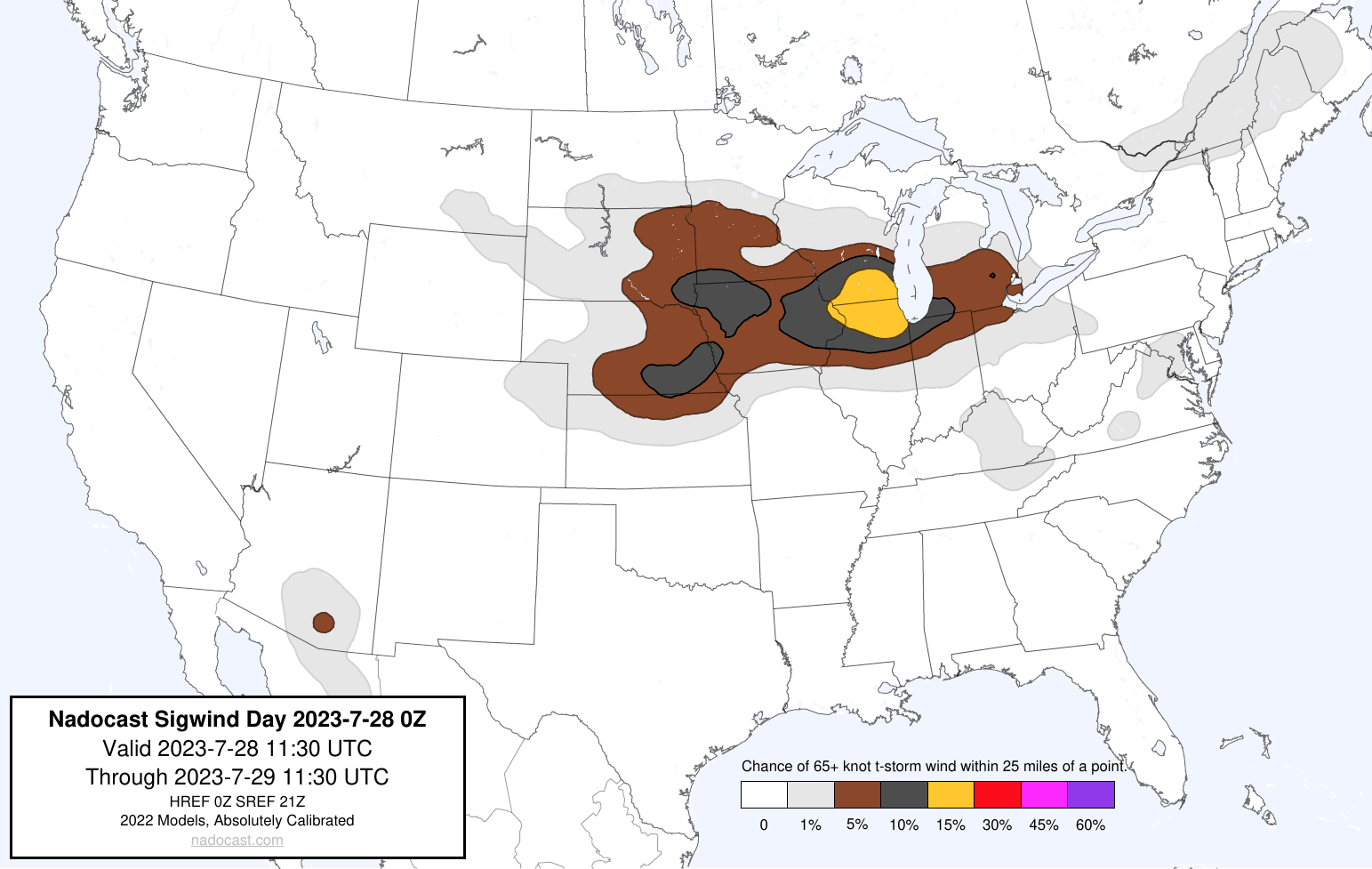
Not sure how well Nadocast does for wind, but definitely has that Derecho look for tomorrow.

-
Inb4 Northern Illinois supercells this afternoon.
-
 4
4
-
-
And round 2 to follow still in Southeast Minnesota?
-
Latest 12z HRDPS showing a look similar to the Chicago double Derecho on June 30, 2014 except further east
https://www.spc.noaa.gov/exper/archive/event.php?date=20140630
-
Repeat of today this Friday? Looks interesting at least
-
1
-
 1
1
-
-
Sirens just started in the city
-
Well a lot happened since my post this morning. Sheesh. Finally seeing filtered sunshine downtown Chicago.
-
If the MCS dies quicker, still decent potential for severe in NIL, but looks very conditional. 12Z HRRR for example. Will need to watch incoming CAMs to see if they follow, and observations.
-
KORD office was riding the HRDPS and it looks like it performed very well with this
-
Looks like the European model was upgraded, including adding a lot of extended ensemble runs. Will be interesting to see how it performs!
-
4 minutes ago, hawkeye_wx said:
This guy's daily briefings on YouTube are great. He goes into detail about the drought and why it continues to be so difficult to get rain in our region.
He was a fantastic UIUC atmospheric sciences professor!
-
Tons of hail in Buffalo Grove right now. Ground is fully covered.
-
3
-
-
Long range 03z Rap popping some PDS Tor soundings in Chicago Wednesday morning. Something to monitor
-
Very late day 2 convective outlook.
-
Would be great if the RRFS comes back online soon in time for the upcoming severe event. Seems to be offline still since Friday
-
1
-
-
10 minutes ago, Natester said:
If I remember correctly it has happened back in May 2003. May 4, May 8 and May 10, 2003 all had high risks in the same latitude, albeit slightly south.
GFS trending in the direction to add to those
-
Has back to back high risks occured at this latitude within 5 days of one another before?
-
Just now, Malacka11 said:
I've been entertaining the idea of just heading farther SW so that I can ride those storms back or bailing head west to catch the second wave
With how fast these storms are, that's a good idea.
-
1
-
-
7 minutes ago, Malacka11 said:
About to hit the road in Naperville. Late to the game. Somebody who knows what they're doing, tell me where to go.
Latest NWS Chicago update says you might be able to even sit tight in Naperville now that round 1 is more likely to be surface based FYI
-
1
-
-
Funny that a large blob of clouds is over the northern High Risk zone. That isn't going to affect the instability there?
-
Incoming High Risk for Western Illinois. Wow
-
1
-
-
Spotty sun poking through in the Chicago area now too.
-
1
-
-
I know weather models were discussed a couple weeks back. Looks like the RRFS model has been added to Pivotal Weather, so should be interesting to see how well it does with the next couple of severe weather events. And just checked out it's 0z run, this won't be useful at all haha
-
 1
1
-
-
Sneaky 2nd low pressure system the following Monday now or a mirage?
-
1
-
July 28th Severe Weather
in Lakes/Ohio Valley
Posted
North moving boundary extremely evident on satellite