.jpg.7212c88cd7a6ee918250d4a9d2a8d183.jpg)

Chicago916
-
Posts
176 -
Joined
-
Last visited
Content Type
Profiles
Blogs
Forums
American Weather
Media Demo
Store
Gallery
Posts posted by Chicago916
-
-
I feel like whoever sits under the 2nd band developing to the south of the first will be the big winner.
-
 1
1
-
-
Steady snow here with dendrites growing larger since 10 minutes ago. Coated sidewalks instantly. Looks like this first band will continue drifting North so hoping the radar fills in more southwest of here.
-
Whiteout conditions briefly by me in Avondale. Was there a snow squall warning?
-
For the crazy SREF watchers, going to get a LOL worthy run at 21z. Going to be interesting if by some miracle the American models end up being correct about a stronger more NW storm.
-
3 minutes ago, Hoosier said:
If I were LOT, I don't know if I'd even bother issuing an advisory in most of the cwa. Total amounts may make it into advisory criteria in some areas, but magnitude of road impacts are questionable overall. And for Chicago metro, precip onset doesn't look to be until around the start of rush hour Wednesday morning, so not like there will be ample opportunity for conditions to go to shit prior to the commute.
The best argument for an advisory may be the ridiculous lack of snow so far this winter, lol
Unless the NAM keeps trending north and is correct and the Metro gets 6+ inches of lake enhanced snow that sticks due to higher rates (if only)
-
3 minutes ago, Chicago WX said:
0z EPS still has some left leaners (deeper solutions) at 90 hours.
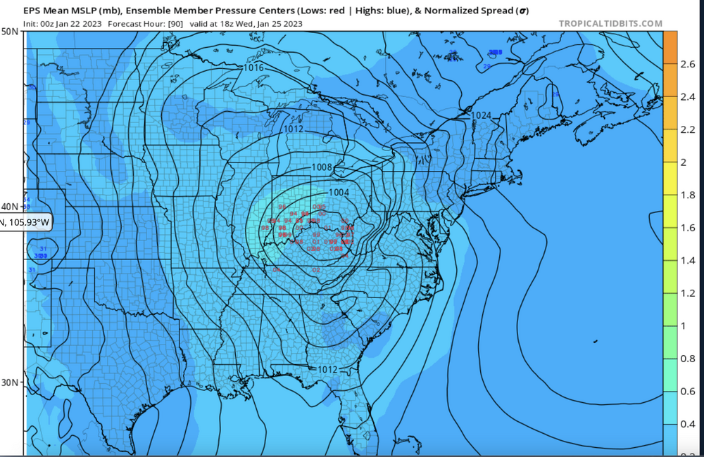
Given it looks like 6z improved, and the left leaning members are deeper and likely fling more precip into the "cold" sector, I'm liking these trends.
-
Anyone have 06z EURO? On tropical tidbits it looks 2mB stronger at 72 hrs and more north again.
-
I'm sure some of you have seen, but great thread on forecasting.
I've seen several great threads by the Lincoln,IL Twitter account this week so props to them!
-
1
-
-
Looks like the orientation of the trailing energy that comes onshore will make or break the storm. Looks like that won't make it to the NW until 24-36 hours from now.
-
Long range NAM gonna NAM? Or some good trending for once?
-
Looks like the energy for this storm didn't quite make it to land prior to 12z runs but might just in time for 18z if that changes anything.
-
GFS and EURO trend of digging deeper in the SW and more positive tilt as it ejects is no bueno for a more north path.
-
1
-
-
Despite the unfavorable GFS OP, the GFS ensemble members look fairly similar at least for now
-
2
-
 1
1
-
-
This storm is doomed. Sunday will outperform this one.
-
Maybe if we don't create a thread for the potential storm next week it'll trend positively
-
2
-
-
Given the overall above average temperatures and above freezing temperatures, I'm curious how the Great Lakes ice cover compares to other years.
-
Another foot with next week's storm in MSP and this is accomplished fairly quickly.
-
Who's first objectives upon posting in a weather forum are to first praise the GFS and deny climate change.... Amazing.
-
 8
8
-
-
We're definitely going to get a perfect low track next week for a snowstorm without any cold air (for Chicago)
-
Who's now excited to track this Arctic clipper on Christmas that will somehow end up missing the region all together or trend downwards into flurries!?
-
Have a feeling we're about to get "that" NAM run for Chicago. Based on the SREF.
-
Weenies should take a peak at the latest 15Z SREF for hope. Lots of sub 980 members while in Northern Indiana still lol
-
I'm not a MET but I have to think the GFS is undoing the precipitation to the west of a rapidly strengthening low?
-
 1
1
-
-
As expected, GEFS and GFS suck and the latest GEFS (mean snowfall) has brought a decent snow back to Illinois. Some duds in the mix as well as crazy totals.
Jan 28-29th Baroclinic Rider
in Lakes/Ohio Valley
Posted
Based on the trajectory of the south band so far, looks like "northern" cook and points west are in the jackpot zone?