.jpg.7212c88cd7a6ee918250d4a9d2a8d183.jpg)

Chicago916
-
Posts
175 -
Joined
-
Last visited
Content Type
Profiles
Blogs
Forums
American Weather
Media Demo
Store
Gallery
Posts posted by Chicago916
-
-
Tis the season of Spring where warm fronts seemingly get stuck pushing north of the south tip of Lake Michigan.
-
Peeps in Southern WI going to enjoy the last bout of snow for the season on Friday? Glad that it'll pass North of here at least...
-
 1
1
-
-
Hints on some of the CAMS of the lake effect band shifting west for a little bit towards Cook.
-
 1
1
-
-
Benefits of an Arctic air mass being it won't take much QPF to result in accumulating snows, and the lake will now be beneficial vs. detrimental to those lakeside.
-
1
-
-
32 minutes ago, Stebo said:
It's not alone either. Tomorrow night could be a surprise.
And now models trying to show lake effect action afterwards
-
Thursday and Friday look interesting for some snow? Lake enhancement/effect possible? Higher ratio snow without mixing issues.
-
Possible WAA snow set-up in the region Thursday? I feel like years ago we had a couple of those with big over performers in the local area?
-
2
-
-
Also only an in or so in Avondale. Not very accurate map. On second look this is showing accumulation and not current snow depth, so it might be correct given all the melting and compaction.
-
Notwithstanding needing the precipitation to switchover to snow in Chicago, the radar trends look pretty good despite the pessimism?
-
2
-
-
Might be grasping at straws, but some good trends for the eastern sub if this continues. Could also just end up as a nor'easter and stop trending west.

.thumb.gif.a83f8edb763ce809f05aece95cba8f33.gif)
-
2
-
 1
1
-
-
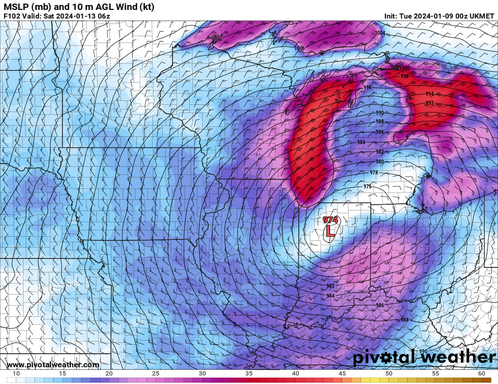
End of the 03z HRRR is wild. Transfer of energy from one sub-980 Low to another. Like a nor'easter in the Midwest. Secondary Low causes temperatures to crash.

-
3
-
-
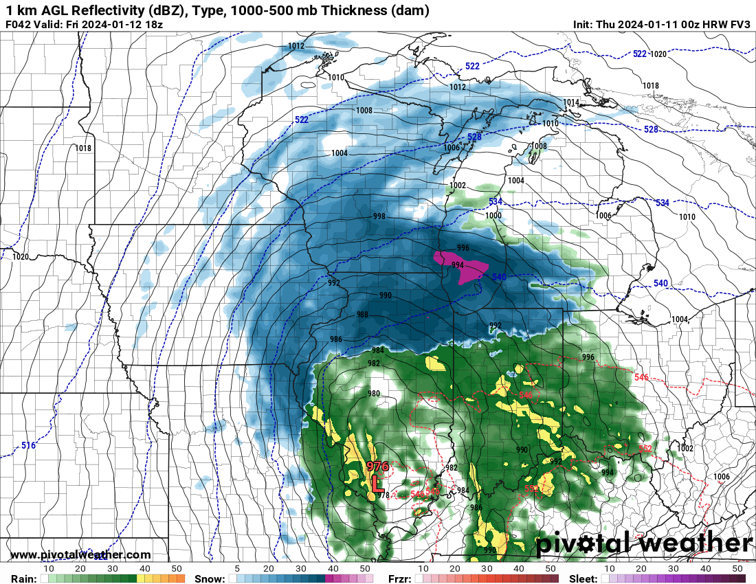
If the NAM and long range HRRR and RAP are the only models not showing high totals then that's a good thing. Looks like globals and even HRDPS and FV3 really hammering most of NIL with heavy snow.
-
Screw the NAM when we have the FV3. This is more like it lol is it showing dynamic cooling as the low deepens or what?

-
1
-
-
Going to be a fun time for anyone commuting from the burbs back to the city for the evening rush. Glad I'm not one of them.
-
Just puking snow by me right now.
-
1
-
-
If anyone wants a laugh, check the early SREF spread in snow totals ... 1in to 20in and still snowing possibly.
-
0 snow here in Avondale and caught a maintenance guy at my place salting anyways
-
Anyone catch Tom Skilling mention this yet? One of my favorite memories was him discussing the GHD blizzard as soon as the EURO starting showing it a long ways out.
-
16 minutes ago, Chicago Storm said:
For those keeping score locally... The 0z Euro also shifted SE, and keeps most of the metro all snow.
Bet we now see a shared EURO snow map with 30+ inches total post weekend storm now. 30 and some lmao
-
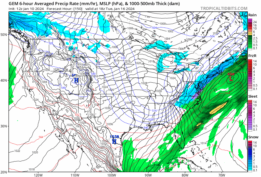
Not to take away from the possible snow, but the cold forecast after this storm looks really impressive. GFS shows below 0 wind chills from 1-13-24 through the end its run...
-
2 minutes ago, metallica470 said:
Looks like it's picking up the lake enhancement?
Looks like a full fetch along the lake towards NE Illinois. Not gonna bother looking into thermals at this range tho.
-
2
-
-
Ukie said hold my beer
-
1
-
-
17 minutes ago, Thundersnow12 said:
Borchardt coming into work tonight for LOT and just straight up disagreeing with previous shifts snowfall forecast. Loser
Was gonna comment how confused I was reading that. Seems like things trended wetter and maybe snowier across much of the area. I thought 6:1 ratios were expected all along.
-
With SREF shifting more south I bet the 0z NAM comes up huge for NIL and SE Wisconsin
-
1
-
.gif.1ba2564468d080f4b6e2c3e2487134f0.gif)
Spring/Summer '24 Banter and Complaint Thread
in Lakes/Ohio Valley
Posted
Possible low topped supers Tuesday could be fun. Knowing IL is the new tornado capital wouldn't be shocked to see a couple