
PantherJustin
-
Posts
738 -
Joined
-
Last visited
Content Type
Profiles
Blogs
Forums
American Weather
Media Demo
Store
Gallery
Posts posted by PantherJustin
-
-
Does anyone know anything About Harrisonburg VA? I’m possibly moving there or Cumberland MD by end of Summer. Ik it won’t be as difficult to see snow there but Scientifically like here We need so much to have an actual snow event. It’s gotta be as simple as hey it’s Cold.... here comes QPF oh hell welp congrats snow! In that area I’d imagine. Anyway didn’t know if anyone had and scientific support to it
-
HRRR wanting to put another .1-.2 on Border Counties and Up into VA.... seems a bit excessive
-
6 minutes ago, CentralNC said:
Yes but don't put MAJOR in the title!
“Our last Bust of the year 2021” Thread
-
1 hour ago, WinstonSalemArlington said:
Lawd
Should we from now on instead of cutting totals in half cut them down to 15% of what’s shown? Just to save ourselves the heartbreak

-
 1
1
-
-
1 hour ago, magpiemaniac said:
Friday, February 26 looks incredible on the 12z GFS.
And it pisses me off to no end that it really won’t happen.

If it’s still there Feb 26th can we start a Thread? Lol
-
2 hours ago, Wow said:
The ice, as expected, was a bust.
I shouldve known when I didn’t see you posting ..... not to get excited from now on if I don’t see you or Grit get excited I’m out lol
-
Maybe this is too far to laugh at these guys up north but come on man.... Idk if it’s worth all that? You stayed in bed all day bc of Model Trends ? Dude you should discover Women, or Alcohol, or Like Anything else in life
-
5 minutes ago, WinstonSalemArlington said:
DC outrage as snows fails to show again!
https://twitter.com/MatthewCappucci/status/1362408652943032325?s=20
Good
 didn’t they just get like 1’ last month? Those guys cry more than anyone on our board
-
Saw Matt East Tweeted Salisbury is at 1/4” any Salisbury posters here?
-
51 minutes ago, wncsnow said:
The models are a complete joke. They have been so wrong here this winter you may as well look at a wooly worm to predict the weather.
Exactly, I honestly wasn’t “Whining” lmao but yea I agree let’s just go back to using a Wind needle and Compass or hang a flag on top of our house and Get Telegrams from DC every 24hrs
-
1/10” here in Mooresville but I think that’s about gonna be it....JOKE
-
I like Brad and IK he’s just trying to “Calm the Nerves” of Meck Ppl but this is false. Everywhere around him is 30/31 in Iredell/Rowan/Parts of Lincoln/N Meck
-
1
-
-
2 minutes ago, kvegas-wx said:
Almost looks like the triad and most of central NC is getting dryslotted! Ugh!! These models are so bad right now.
Absolutely horrible. It’s insane how they can be so far off .... we may as well just go back to checking barometric pressure and guessing off a telegram sent from DC
-
2
-
-
2 minutes ago, AirNelson39 said:
Nothing like heavy rain and 32.4 degrees. What a joke.

Yikes.... guess that band warmed you?
-
14 hours ago, PantherJustin said:
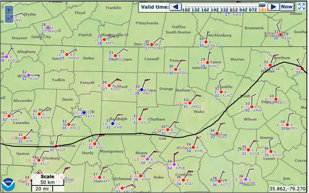
44/25 in Mooresville not sure what I was Shown on NAM currently. I still stick with my idea the Ice line will halt on HWY73 up to HWY152 somewhere in there South of there I doubt goes below 32/33 at all N of there 31/32 Includes Huntersville- Concord/Kannapolis up To China Grove - Mooresville ..... Point blank you all know your area and how it performs in CAD , If you normally hold longer you will tonight as well if not you won’t. Climo and history will repeat itself more times than not. Someone tell me if I’m wrong on that though
“HWY73 Cutoff”
-
31.6/31 here In Mooresville light Rain boy this thing looks awfully wimpy on Radar.... Light Glaze on Cars/Deck To have looked so bad the other day certainly looks soft today

-
04z HRRR Initialized the LP about Pensacola it’s still about 50 Miles Due South of NOLA so that’s a good 100 -150 Miles too Far NE not sure if that means anything downstream or not
-
Certainly looks Colder than the one he posted a couple hours ago. From 3-11A Counties N of Meck 30-32 .... Freezing line down on NC/SC border
-
1
-
-
1 minute ago, WXNewton said:
00z GFS says hold my beer and throws down some big ZR totals! Probably doesn't matter at this point what it shows.
Yea I saw that lmao
-
HRRR initialized Pretty much on the money this time.
-
7 minutes ago, griteater said:
It's all part of forecasting. Not just interpreting the models, but trying to predict ahead of time where they will end up at go time. Not easy
True, I guess as someone who’s still rather new.... What happens to cause the NW Shift back majority of the time?
-
6 minutes ago, eyewall said:
I said earlier we saw this more than once this winter where the models get aggressive as we close in on an event only to pull back at the last second. It got RAH a couple of times. I wonder if we are seeing it again now.
I understand, but what causes the 24hr swings? I mean should we just take the most southerly trend and push it back 50 miles even before guidance does? Basically I’m trying to understand what happened since 11 last night to cause it ..... is it as simple as Climo?
-
3 minutes ago, WXNewton said:
There are several stations in N.Catawba already reading 31.2-31.8. Clouds are starting to roll in so I expect that to jump up some in the next hour. 5-7 mph stiff NNE wind.
I’ve been stuck at 35/36 clouds here now .... It’s right there though Troutman 33
-
6 hours ago, wncsnow said:
Looking more like a northern piedmont special. Winston to Burlington north to the state line
Isn’t everything that same exact area? Lol
Winter 2020-2021 whining thread
in Southeastern States
Posted
Thanks, that part would be cool but it looks like a sleepy place. I’ve grown up in CLT metro basically my entire life (Concord / Speedway area) now LKN. I’m a city guy lol I moved to Mt Ulla/Salisbury area after my first marriage in 13’ until 18’ I hated it , so rural nothing around. Idk I’m sure it will be a life adjustment if it happens