HornetsHomer91
-
Posts
751 -
Joined
-
Last visited
Content Type
Profiles
Blogs
Forums
American Weather
Media Demo
Store
Gallery
Posts posted by HornetsHomer91
-
-
7 minutes ago, WinstonSalemArlington said:
29/20 Here in Mooresville and Cloudy. Would be nice to see DP dip some more
-
29/20 here and Cloudy (Southern Iredell) saw some ppl posting about DP. High is supposedly 47 today if it stays cloudy idk if we get there
-
20 minutes ago, WinstonSalemArlington said:
Is Eric Thomas still at WBTV? How are things at WSOC?
Yea. But he’s the Brad P of WBTV. He’s been there my Entire life so he’s Eve/Night guy. Like Udelson I believe at WSOC. Both have been there pretty much my entire life
-
 2
2
-
-
Did anyone else see on 3K NAM the 1035HP sitting PA/NY border then at HR21 then By HR24 it’s Bullied all the way NW of Niagra Falls? Doesn’t that seem a bit excessive? Or am I just missing something.
-
11 minutes ago, wxduncan said:
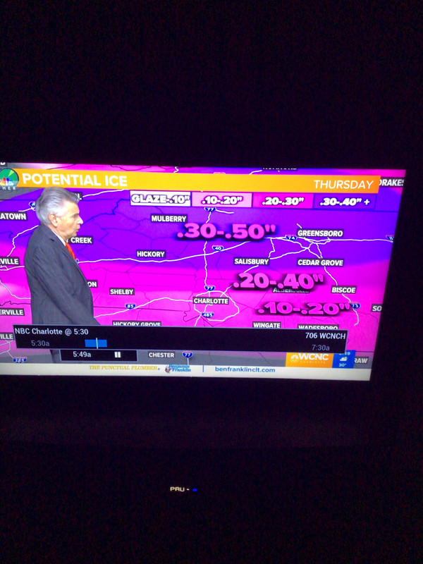
Well I would go with WCNC at least there forecast is going with what GSP is saying and the latest guidance. Also that map there showing is there in house model not actual forecast map like WCNC.
Nah ik. But that’s all I could find for other channels. I wasn’t trying to bash ect. Al is actually pretty cool
-
10 minutes ago, wxduncan said:
Meanwhile over off Morehead and Freedom Drive at the other Charlotte station ....

-
 2
2
-
-
14 minutes ago, wxduncan said:
Go look at the one they just put out it’s way up and will likely go higher.
Still looks a bit soft. But I guess no need to predict An apocalypse just yet as we still have 18hrs to flip flop. (Maybe they’re expecting a correction back NW trend wise slightly) I don’t see any reason ALL areas Along/ NW of I-85 even in Meck/Cabarrus shouldn’t be 1/4” +. Honestly I’d just put a blanket 1/4 -1/2” Swath over the entire Forecast area in NC (Minus Monroe) no need for specific amounts
-
3 hours ago, Blue_Ridge_Escarpment said:
GSP back at the wheel this morning...
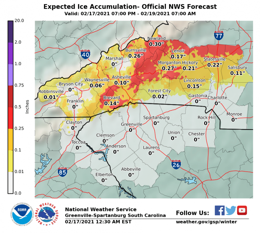
I live in Iredell but this still looks awfully Conservative compared to even Brad P and anything else I’ve seen. If I’m missing something someone tell me.... but How do they Have Charlotte/Concord at Nothing Zero absolutely nothing? While Others have that area 1/10-1/4” , That doesn’t make sense
-
4 minutes ago, HKY_WX said:
RDPS is trending the best ZR accrual towards the Triangle as the trends south continue. Looks like more sleet for the VA border counties if this is to be believed. I'll post a map tomorrow for those interested. (I usually only post maps for significant/major systems) fyi.

I don’t wanna be that guy.....but the trajectory of that heaviest axis is starting to look awfully similar
-
26 minutes ago, wncsnow said:
Some of the short range suite NAM ice totals
.thumb.png.e3c9b305306c343d723995a757366e22.png)
.thumb.png.714cd6695c34185aca60904b1f68a0f7.png)
.thumb.png.9121c1b9018f11746548343e2ff3e776.png)
Brad P is actually sounding pretty Concerned..... used to I’d disregard, but he’s become insanely Conservative over last 5yrs or so, so if he’s starting to sound worried I’d start preparing. He said in his latest Video that Its concerning More Cold Air is starting To leak over the mountains than expected tonight
-
 1
1
-
-
12 minutes ago, Buddy1987 said:
One thing I really love to see, unlike other storms where we’ve been completely borderline going into, is temp has dropped to 27 and dew is down to 16 here. Great indicator for the upcoming system.
33/22 here Mooresville
-
1 minute ago, wncsnow said:
.thumb.png.6b9d439378c290ae1f34bca8c96dd613.png)
Goodness even the 3K Puts 3/4+ on Iredell/Rowan/Catawba Counties
-
1
-
-
25 minutes ago, Blue_Ridge_Escarpment said:
No shortage of precip on the HRRR
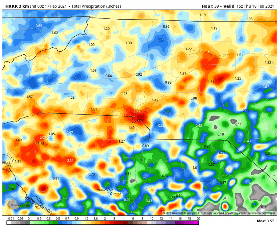
Woof better hope that’s Sleet or this thing is gonna blow 2002 out of the water in CLT Metro
-
Widespread 1/2-3/4” amounts verbatim N of Meck County
-
HR33 1034 HP over N PA/SW NY Border LP over New Orleans
-
NAM out to 27hr 1032HP over Erie PA SN/Mix over NLA/Mississippi/Arkansas
-
2 minutes ago, WSNC said:
Not sure about other areas, but the HRRR has been pretty good in my area for ptype this year.
Same, HRRR nailed the event 2 weeks ago so time will tell
-
4 minutes ago, wncsnow said:
For what it's worth the HRRR is heavy sleet for many
.thumb.png.42520aee7f0817d67994af188007a694.png)
As Hickory said earlier it makes more sense with The LP Track
-
7 minutes ago, olafminesaw said:
FRAM isn't a model, it's an algorithm that calculated true accrual of ice. It tends to be much more conservative than just straight accumulation maps.This is why it's concerning, because it will account for the portion of the rain that's just runoff.
Ahhh dear lord Thats rough then
-
Just now, WXNewton said:
I think this might be the in house model that Brad P. uses.
I’ve wondered I’ve never seen the FRAM model
-
EURO Running, Out to 24 1033HP over SE Ohio by Hr 36 on Hi-Res EURO HP shoots from SE Ohio- NE NY ....seems a bit odd
-
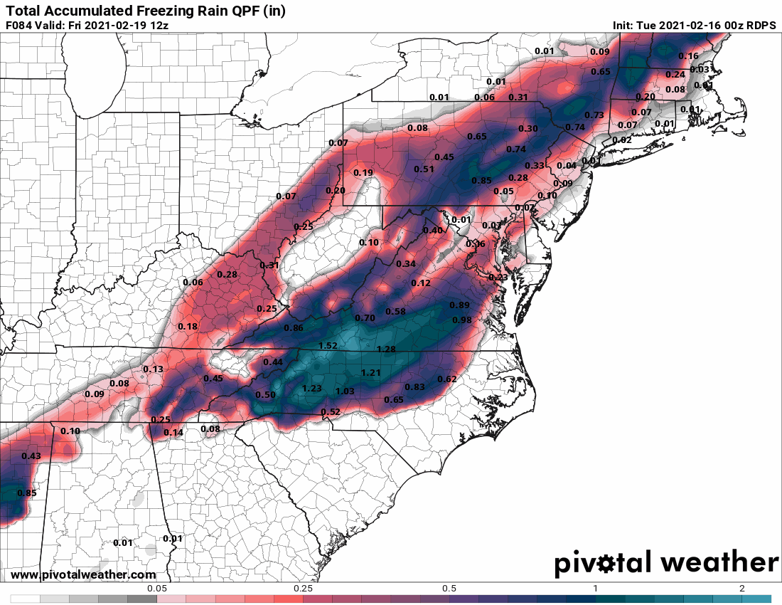
RDPS put 1-1.5” FRZN in a Box Roughly Iredell-Wake and up to VA .... My goodness
-
Not that anyone Cares about RAP.... but at 21hrs (end of its Range) it does have the HP on IL/KY/IN (Evansville IN) border where GFS has it way over Columbus-Canton OH. That’s 300-350 Miles Further SW you’d have to think that may make a difference in a scenario like that down the line
-
5 minutes ago, magpiemaniac said:
Looking at your house on the latest model run map and saying this isn’t going to be a serious event does everyone else a disservice. This thread covers a lot of territory. Some will get a cold rain. Others could be without power for two or three days. We have people reading this thread who don’t post, but would like get a sense of what might be coming.
Exactly. And the NAM may look warmer but it’s definitely not, if anything it brought heavier amounts further SE in CLT area. ANYONE along and NW of 85 Or a Line From Shelby-Concord-Lexington-NW Wake County Should prepare for an ice storm and Be pleasantly surprised if you end up not needed the extra supplies


.png.25b58cdd72874924f517843629fa120c.png)
.png.5d5b338ed5838ebb41d0984d90e71b26.png)
.png.ef6925459056f1ad0e5ad9f9454cd2fc.png)
.png.695036d0f9bff5afb756dde9e9074a08.png)

.png.e68ece453a9f082746b23d91b9424211.png)
February 18-19 MAJOR Ice Storm Threat
in Southeastern States
Posted
The NAM unless I’m looking at it wrong (Pivotal Map) doesn’t even barely have Precip into Foothills even at 6Z Tomm.... could be a reason it seems warmer Jmo I think earlier onset the Colder obviously Edit: As Well as the HP is 75-100 miles Further NW than 6Z run