HornetsHomer91
-
Posts
751 -
Joined
-
Last visited
Content Type
Profiles
Blogs
Forums
American Weather
Media Demo
Store
Gallery
Posts posted by HornetsHomer91
-
-
2 minutes ago, kvegas-wx said:
Almost looks like the triad and most of central NC is getting dryslotted! Ugh!! These models are so bad right now.
Absolutely horrible. It’s insane how they can be so far off .... we may as well just go back to checking barometric pressure and guessing off a telegram sent from DC
-
 2
2
-
-
2 minutes ago, AirNelson39 said:
Nothing like heavy rain and 32.4 degrees. What a joke.

Yikes.... guess that band warmed you?
-
14 hours ago, PantherJustin said:
44/25 in Mooresville not sure what I was Shown on NAM currently. I still stick with my idea the Ice line will halt on HWY73 up to HWY152 somewhere in there South of there I doubt goes below 32/33 at all N of there 31/32 Includes Huntersville- Concord/Kannapolis up To China Grove - Mooresville ..... Point blank you all know your area and how it performs in CAD , If you normally hold longer you will tonight as well if not you won’t. Climo and history will repeat itself more times than not. Someone tell me if I’m wrong on that though
“HWY73 Cutoff”
-
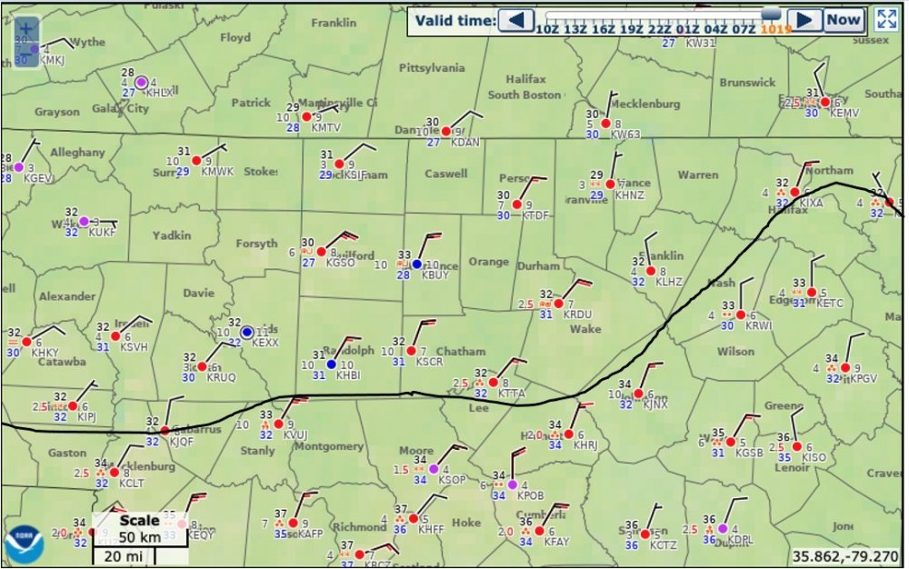
31.6/31 here In Mooresville light Rain boy this thing looks awfully wimpy on Radar.... Light Glaze on Cars/Deck To have looked so bad the other day certainly looks soft today

-
04z HRRR Initialized the LP about Pensacola it’s still about 50 Miles Due South of NOLA so that’s a good 100 -150 Miles too Far NE not sure if that means anything downstream or not
-
Certainly looks Colder than the one he posted a couple hours ago. From 3-11A Counties N of Meck 30-32 .... Freezing line down on NC/SC border
-
1
-
-
1 minute ago, WXNewton said:
00z GFS says hold my beer and throws down some big ZR totals! Probably doesn't matter at this point what it shows.
Yea I saw that lmao
-
HRRR initialized Pretty much on the money this time.
-
7 minutes ago, griteater said:
It's all part of forecasting. Not just interpreting the models, but trying to predict ahead of time where they will end up at go time. Not easy
True, I guess as someone who’s still rather new.... What happens to cause the NW Shift back majority of the time?
-
6 minutes ago, eyewall said:
I said earlier we saw this more than once this winter where the models get aggressive as we close in on an event only to pull back at the last second. It got RAH a couple of times. I wonder if we are seeing it again now.
I understand, but what causes the 24hr swings? I mean should we just take the most southerly trend and push it back 50 miles even before guidance does? Basically I’m trying to understand what happened since 11 last night to cause it ..... is it as simple as Climo?
-
3 minutes ago, WXNewton said:
There are several stations in N.Catawba already reading 31.2-31.8. Clouds are starting to roll in so I expect that to jump up some in the next hour. 5-7 mph stiff NNE wind.
I’ve been stuck at 35/36 clouds here now .... It’s right there though Troutman 33
-
6 hours ago, wncsnow said:
Looking more like a northern piedmont special. Winston to Burlington north to the state line
Isn’t everything that same exact area? Lol
-
4 minutes ago, Grayman said:
I’m smell bust.
Isn’t everything on this forum a bust?
-
1
-
-
6 minutes ago, WXNewton said:
What to? So funny, was talking about the models running too warm today and now said the trend was to warm us up more. LOL!!
He basically said this warm nose is gonna be so strong it warms most to 33 but looking at the “Futurecast” it still had Iredell/Rowan/Catawba at 30-32 for a good chunk so I almost think he’s more so talking about CLT immediate
-
1
-
-
2 minutes ago, wncsnow said:
32.0/25.5
You made it!!
 So Much for that EURO Run lmao
-
 1
1
-
-
36/27 Here in Mooresville Clear Skies still. I think we’re gonna make it to 30
-
1 minute ago, NorthHillsWx said:
While an interesting note, the air this system will be working with here has absolutely no connection to the cold air that settled west of the apps. I’d be looking north of here for temp/dew point trends vs model outputs in terms of verification of our winter event
Gotcha thanks!
-
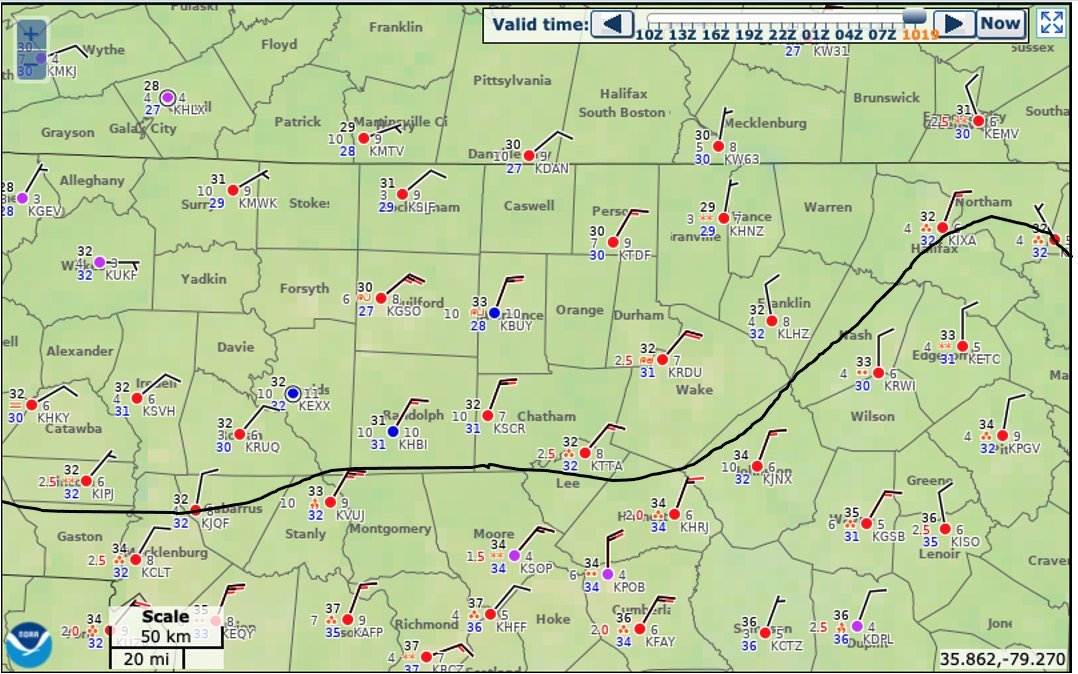
Seeing Reports of 32 and and IP/FRZN (I doubt it’s Sleet) about 5 miles SE of Lafayette LA that’s DEEP South. 32 And FRZN Abbeyville LA Directly On Gulf Coast. My point is let’s start checking 18Z suite to see who had <32 that far south..... Basically I-10 Corridor
-
I love how Literally just about every Met I’ve seen someone post on here has Iredell/Catawba/Rowan area anything from All Rain/ Glaze - .1 / .1- .25/ GSP .3-.5 I mean hey.... one of them has to be right I guess

-
44/25 in Mooresville not sure what I was Shown on NAM currently. I still stick with my idea the Ice line will halt on HWY73 up to HWY152 somewhere in there South of there I doubt goes below 32/33 at all N of there 31/32 Includes Huntersville- Concord/Kannapolis up To China Grove - Mooresville ..... Point blank you all know your area and how it performs in CAD , If you normally hold longer you will tonight as well if not you won’t. Climo and history will repeat itself more times than not. Someone tell me if I’m wrong on that though
-
Everyone relax
-
1 minute ago, NorthHillsWx said:
Some people never learn
This isn’t FT Worth or Slidell LA we gotta tread a fine line or it’s no fun come on

-
2
-
-
9 minutes ago, WeatherWeenie87 said:
Feel sorry for the NWS folks. I have a feeling this might be a NC/VA border Ice Storm. HRRR, NAM, and Euro have verified warmer than forecast. If this would have happened 10 to 20 years ago, this would have been almost all snow. This is why analogs are useless now.
Almost all of NC is above freezing wet bulb temperatures now.
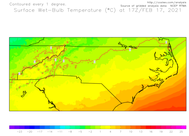
No way..... CAD is normally Better than Modeled. I would Think Anyone North of HWY73/152 will be just fine as far as Cold those areas always stay Colder longer.
-
2 minutes ago, BullCityWx said:
Brad Panovich said he is very concerned that the modelling is underestimating the depth of cold air.
Not that it matters .... but I’m still at 35/22 Forecast high was 45-47 ... idk
February 18-19 MAJOR Ice Storm Threat
in Southeastern States
Posted
I like Brad and IK he’s just trying to “Calm the Nerves” of Meck Ppl but this is false. Everywhere around him is 30/31 in Iredell/Rowan/Parts of Lincoln/N Meck