
PantherJustin
-
Posts
738 -
Joined
-
Last visited
Content Type
Profiles
Blogs
Forums
American Weather
Media Demo
Store
Gallery
Posts posted by PantherJustin
-
-
2 minutes ago, NorthHillsWx said:
Well, this escalated quickly
Happy for you guys … but selfishly wishing for about 50-75 miles More

-
 3
3
-
-
2 minutes ago, Beach Snow said:
From DT on twitter. As much as i don’t like him he has a point. Wonder if this will cause implications for the Friday event?
If it comes in weaker won’t that not suppress it and squash it as much? Ala NW Trends
-
3 minutes ago, Sandstorm94 said:
It was, compare below:


Sent from my SM-S115DL using Tapatalk
Much better…. It’s trying …. Haven’t had a chance to look at Vort maps but it’s a step for sure
-
2
-
-
18 minutes ago, nwohweather said:
Hot take
While I appreciate sarcasm as much as the next guy ….. I could careless if you or anyone else gets 6 feet or 6 flakes doesn’t make a bit of difference to me. I was trying to lighten the mood in here but I see some ppl don’t have that personality trait to acknowledge humor
-
3
-
 3
3
-
-
1 minute ago, CaryWx said:
Please tell me you're being a bit acetous here
No….
-
25 minutes ago, burgertime said:
March 2009 comes to mind for me. ULL was all over the place and then at the last second folks along I-85 cashed in.
I remember that Burger…. Was a Sr in HS at NW Cabarrus in Concord…. It poured rain all day that Sunday …. Then woke up the next AM and had 5/6” lol
-
11 minutes ago, PackGrad05 said:
WRAL first call map has wake county 3-5 inches. Mike maze said he may shift it southeast a little after looking at new data.
Everyone in Raleigh needs to chill…. These models are way off. We all know by Tomm night it will be right back how it was…. It will change 9x more every run of (model suites) it wouldn’t surprise me if all of them lose it then start creeping back by 06z runs Tomm …. This happens every storm we have a day of crap runs then it ends up just fine or some result not even shown like last weeks HRR …. Stop trusting Computers they have ZERO clue …. Ppl need to go back to looking at Fronts ect on paper and stop trusting computers
-
5
-
 1
1
-
-
22 minutes ago, Brick Tamland said:
From a huge storm on the global models to nothing here in less than 12 hours and only 48 hours out. Going to be hard to trust the models at all outside 24 hours after this one. This is a Falcons against the Pats in the Super Bowl level of collapse.
Brick I love your enthusiasm bro but come on stop posting this man lol
-
8
-
-
27 minutes ago, PackGrad05 said:
Who is DT and where is his page?
A “Moms Basement Met” He’s basically a 2yr old with computer access
-
4
-
5
-
-
2 minutes ago, ILMRoss said:
All the established mets have probably been bit by the NW trend so many times that they're pricing that into all forecasts going forward. They're betting that later guidance will wind-shield wiper back to more qpf-rich solutions, which is reasonable. How about let's get the 3km NAM past 00z Saturday before we really start cliff diving.
And The model GOAT …. HRRR …. It was on an island of its own when Burrel started pumping it last Sat eve And it scored may as well give it a shot in our what have you done lately era
-
1
-
-
10 minutes ago, NorthHillsWx said:
Almost identical to Canadian
Then that means EURO will follow…. It normally follows UK or used to
-
Just now, 85snowline said:
Here in the Robinson HS area in Concord. WBTV very conservative with just 1-3" for the 77 corridor. Where are you seeing 4.5" for your area??
He was talking about last week I thought
-
3
-
-
6 minutes ago, tarheelwx said:
I'm thinking most of us know how to read the models decently and the trend is quite apparent. Unless the Euro comes in and shows something unexpected, the overall tone related to the upcoming storm will change with the afternoon packages. I hope I'm wrong and we get a Jan 25 2000 redux.
By the way Justin, how much snow/sleet did you guys get there at the lake?
TW
4.5” IMBY
-
1
-
-
3 minutes ago, BornAgain13 said:
I believe it's more so of the trend towards less and less precip...
Then why isnt anyone who’s actually a met and not just a moms basement met budging ? Lol
-
4
-
2
-
-
Does anyone else find it humorous…. Ppl that actually know what they’re doing still saying 1-4” all the way back to 321 area…. And 4-6” in Raleigh even after these runs yet this entire forum is in panic mode? I think this is a case of knowing too much for our own good…. Stop taking these computers as gospel positive or negative for your back yard….
-
9
-
-
Guess maybe that small Interaction made a slight difference…. No disrespect I didn’t see a NW trend though
-
2
-
-
To my untrained Eye GFS on the Vort maps tried to sync up a bit but just never happens…. I’m still learning though so idk
-
1
-
-
I should’ve known when I didn’t see @Wow in here since a few days ago it wasn’t gonna happen
 Dude literally lives in same city as me I don’t need to read anything but his comments lol
-
6 minutes ago, wncsnow said:
I'm glad Ward feels that way because the models are trending towards nothing west of 77 and little west of 95.
True… we’re about at that under 8 min media timeout in College basketball…. If we’re gonna make a run it better come soon, not over but we’re running out of time lol
-
1
-
-
2 minutes ago, AirNelson39 said:
Glad the NAM is showing everyone not to put an ounce of trust into at 84 lol. Stick a fork in this one for anyone in western half of the state. Congrats down East! You guys have proven the 4+ day euro is on crack and the 84 hour NAM is on meth.
Lol yea…. I’m about out myself to use sports analysis like we were yesterday this is like in basketball when you’re down 15 and you keep cutting it to 5-7 then they go on a run and jump back out to 15 at some point you just run out of time. You’re never really out but not really in either
-
1
-
-
13 minutes ago, senc30 said:
I know everyone is excited about the snow but being here in Jacksonville, I am extremely concerned about a catastrophic ice event. Am I over thinking this or am I right to be worried?
Nah…. Maybe 1/4” - 1/3” but Models always over do ice
-
9 minutes ago, eyewall said:
I'll take that call any day of the week LOL. Anyway he is definitely a bit more west with higher totals than I would have thought but not impossible.
I can only speak for myself but I believe he’s using a bit of experience with these systems…. How they act Or “Overachieve” in overrunning ect. I didn’t even realize he’d been in CLT on WBTV as long as anyone I guess bc he’s in the morning I never noticed but he’s also been there since I was a kid like BP,Crum,East,EricT(Retired).
-
2
-
-
Al Conklin out Of CLT for those interested also shows Raleigh
-
2
-
 1
1
-
-
@Amos83 I grew up over By Afton but now that I got remarried I moved from Mt Ulla to Mooresville I’m up in Coddle Creek area off HWY3/Rocky River in Iredell

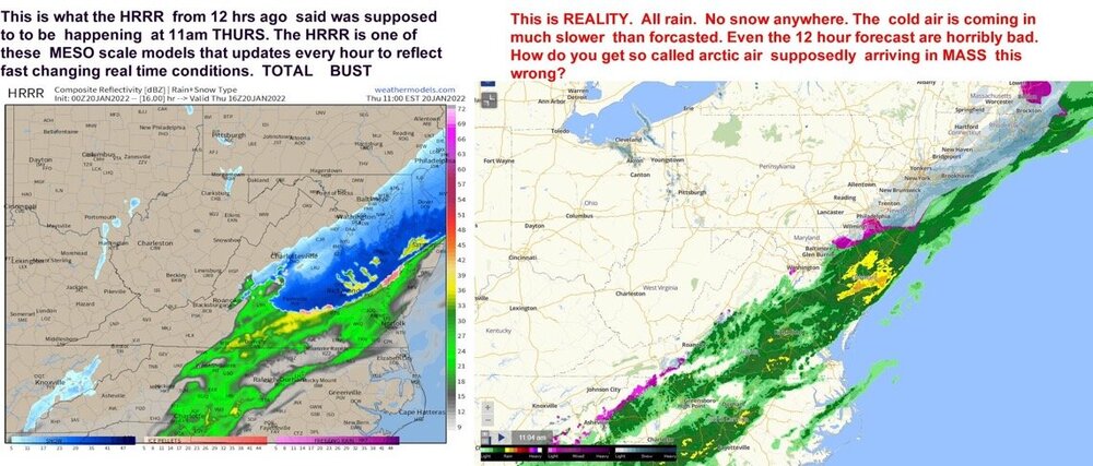
NW Trend For the Win! (1/21-1/22 2022 storm) Obs Thread
in Southeastern States
Posted
39 and miserably wet here in Mooresville/LKN