StormfanaticInd
-
Posts
2,065 -
Joined
-
Last visited
Content Type
Profiles
Blogs
Forums
American Weather
Media Demo
Store
Gallery
Everything posted by StormfanaticInd
-
156 deaths in Ohio
-
Cases in the midwest will probably oscillate but overall trend higher throughout the winter
-
Weather is definitely playing a factor
-
-
Winter 2020-21 Medium/Long Range Discussion
StormfanaticInd replied to Hoosier's topic in Lakes/Ohio Valley
If storm comes together right somebody is going to get slammed -
Winter 2020-21 Medium/Long Range Discussion
StormfanaticInd replied to Hoosier's topic in Lakes/Ohio Valley
Its perfect -
Yep. Probably around December 10
-
"Based on what we’ve seen over the last eight months of state-reported COVID-19 data, we think two big, potentially misleading things are about to happen to the testing, case, and death numbers that allow us to track the pandemic in the United States. First, by Thanksgiving Day and perhaps as early as Wednesday, all three metrics will flatten out or drop, probably for several days. This decrease will make it look like things are getting better at the national level. Then, in the week following the holiday, our test, case, and death numbers will spike, which will look like a confirmation that Thanksgiving is causing outbreaks to worsen. But neither of these expected movements in the data will necessarily mean anything about the state of the pandemic itself. Holidays, like weekends, cause testing and reporting to go down and then, a few days later, to "catch up." So the data we see early next week will reflect not only actual increases in cases, test, and deaths, but also the potentially very large backlog from the holiday. "
-
88,080 hospitalizations today. A new record for the 15th day in a row. We will probably reach 100k by Sunday or Monday. Texas is a recorded for any state
-
2020 Short/Medium Range Severe Thread
StormfanaticInd replied to Hoosier's topic in Lakes/Ohio Valley
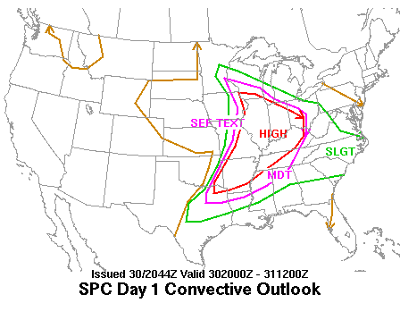
Day 2 Convective Outlook NWS Storm Prediction Center Norman OK 1054 AM CST Tue Nov 24 2020 Valid 251200Z - 261200Z ...THERE IS A MARGINAL RISK OF SEVERE THUNDERSTORMS ACROSS PORTIONS OF THE LOWER AND MIDDLE MS...LOWER OH AND TN VALLEYS... ...SUMMARY... Isolated strong to severe thunderstorms may occur Wednesday across parts of the lower/mid Mississippi Valley into the Ohio/Tennessee Valleys and Southeast. Locally damaging winds should be the main threat, although a tornado or two also appears possible. ...Synopsis... A mid/upper level shortwave trough centered over the Ozark Plateau early Wednesday will lift northeast across the Midwest to the upper OH Valley/central Appalachians by 12z Thursday. Surface low pressure will move in tandem with the upper trough from MO toward the lower Great Lakes while a trailing cold front pushes eastward across the mid/lower MS valley and the lower OH/TN Valley. Ahead of the front, southerly low level flow will continue to transport Gulf moisture northward, with 60s F dewpoints reaching as far north a TN potentially. Surface dewpoints in the 50s will be more common farther north across the Ohio Valley vicinity. Surface heating will be limited by cloudiness and showers ahead of the front, but cooling aloft is expected to result in modest midlevel lapse rates. Furthermore, strong shear profiles are forecast as winds veer with height and 40-60 kt 850-700 mb southwesterly flow overspreads much of the southern/central U.S. This should support at least isolated strong-to-severe thunderstorms capable of strong/locally damaging wind gusts across the lower/mid MS Valley to the OH/TN Valley. ...Lower/Mid MS Valley to the OH/TN Valley Vicinity... Higher-quality low level moisture will be confined to the lower MS Valley into MS/AL on Wednesday. While stronger heating will be limited by cloudiness and showers ahead of the cold front, modest midlevel lapse rates atop rich boundary layer moisture should result in at least weak surface-based instability (typically 750 J/kg or less). Strong shear will reside over the region to aid in organized convection. Deep layer flow will mainly be parallel to the front, favoring line segments, but a couple of semi-discrete cells also are possible. Strong forcing closer to the trough/surface low will be shifting away from the region through the day, but the front and weak buoyancy will be sufficient for strong-to-severe convection into parts of MS/AL and middle TN through early evening. Storm mode and quickly strengthening flow with height will mainly favor damaging wind potential. However, where backed low level flow is present, low level SRH will be enhanced and a tornado or two cannot be entirely ruled out. Farther north, instability will be even weaker given overall poorer-quality boundary layer moisture and a cooler environment. However, steeper midlevel lapse rates with colder air aloft should result in weak elevated instability. Stronger forcing and favorable shear profiles may compensate somewhat for meager instability, and at least a narrow line of near-surface-based convection closer to the surface low and cold front is expected during the afternoon/evening across parts of the lower OH Valley. Strong low level wind field associated with low/midlevel jet streak will favor bowing segments capable of isolated strong/damaging gusts. ..Leitman.. 11/24/2020 -
-
Also 2050 deaths so far.
-
Texas with over 18k so far today on worldometers! Thats unthinkable
-
Winter 2020-21 Medium/Long Range Discussion
StormfanaticInd replied to Hoosier's topic in Lakes/Ohio Valley
-
1900 at 515pm
-
-
Winter 2020-21 Medium/Long Range Discussion
StormfanaticInd replied to Hoosier's topic in Lakes/Ohio Valley
And there is another storm right behind it on that run! -
Winter 2020-21 Medium/Long Range Discussion
StormfanaticInd replied to Hoosier's topic in Lakes/Ohio Valley
The storm just sits there. Wow -
Today is looking like another bad day. We could easily see 2k+ deaths today
-
Winter 2020-21 Medium/Long Range Discussion
StormfanaticInd replied to Hoosier's topic in Lakes/Ohio Valley
The pattern after looks interesting too. Looks like el nino. -
Winter 2020-21 Medium/Long Range Discussion
StormfanaticInd replied to Hoosier's topic in Lakes/Ohio Valley
I want to see another set of runs first. Lol -
DAMN!!!
-
Yesterday's numbers have been revised up by almost 7k


