vortex95
-
Posts
1,488 -
Joined
Content Type
Profiles
Blogs
Forums
American Weather
Media Demo
Store
Gallery
Everything posted by vortex95
-
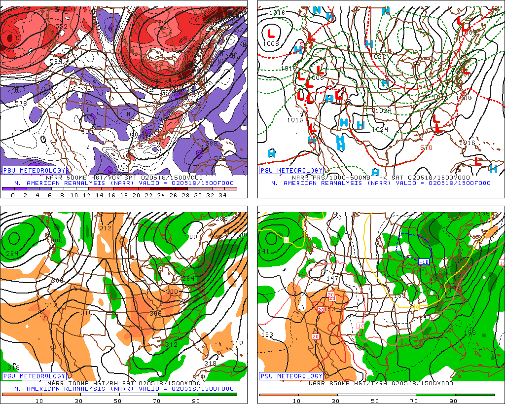
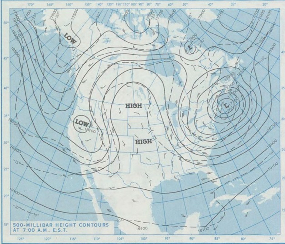
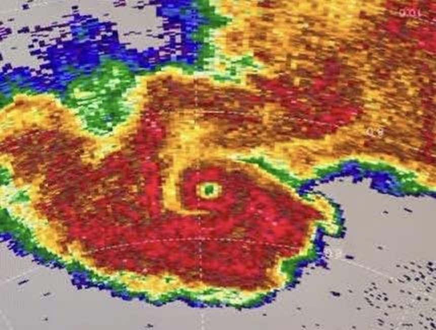
Also, you don't need a honkin' cut-off at 500 to do it in May, at least not directly over New England, nor do you need a strong sfc low. May 18, 2002. This produced what is perhaps the latest accumulating snowfall in ern MA on record. I had .2" in Woburn and this was during the day. You know how hard it is do that this late w/ that sun angle (it still is "felt" though a dense OVC). Also, note it was generally above 540 thk where it snowed. 540 usually does not work so well this late in the season. ALB had 2.2" and max amount was 8" at Prattsvile NY. Weenie snowfall report from this day on this group? I'd like to see them. Omega block once again, but its horizontal axis was not as far S as 1967 and 1977. Of note, 4 days before, CAR had 2.7" for its latest measurable snow on record.
-
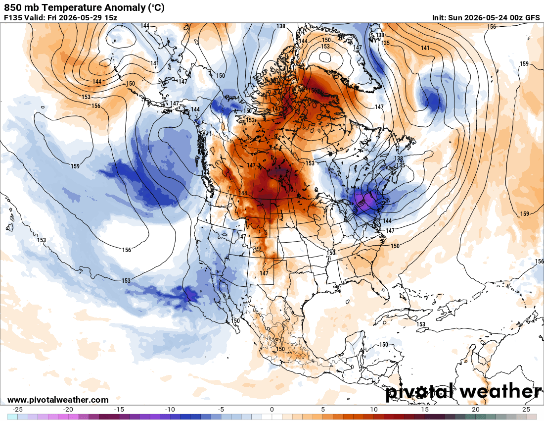
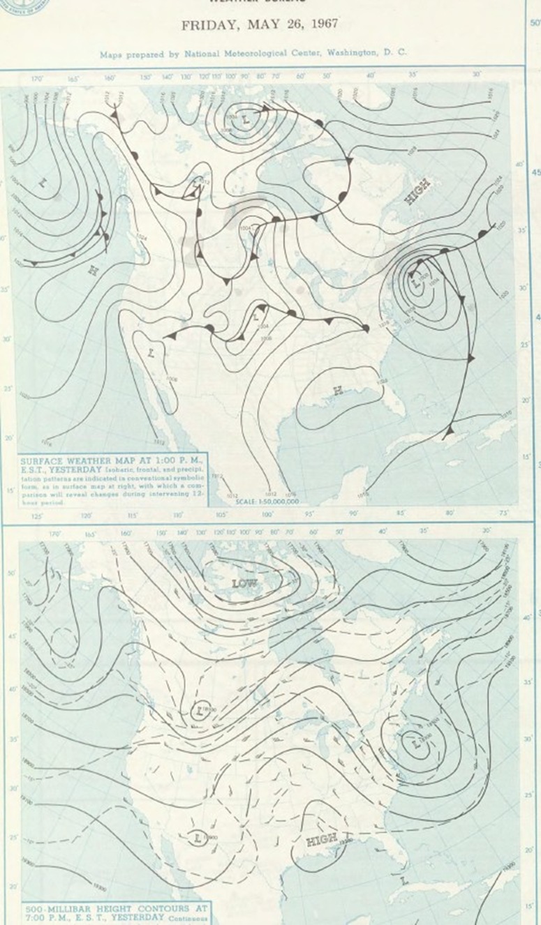
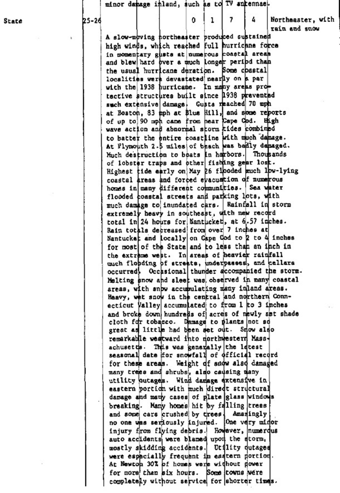
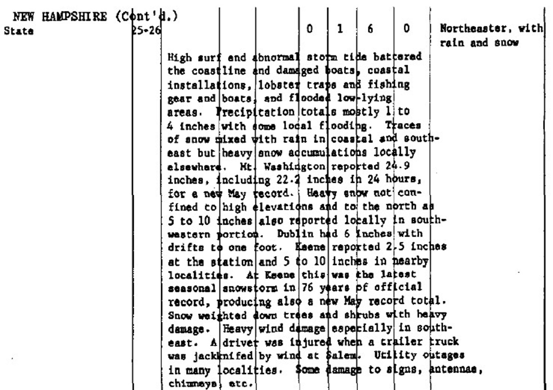
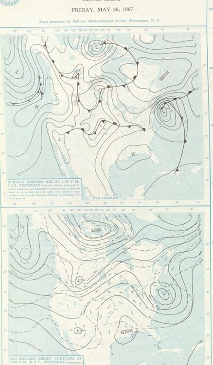
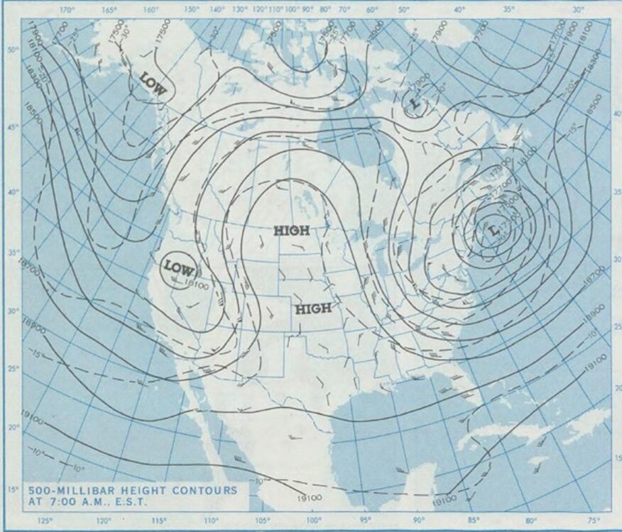
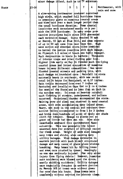
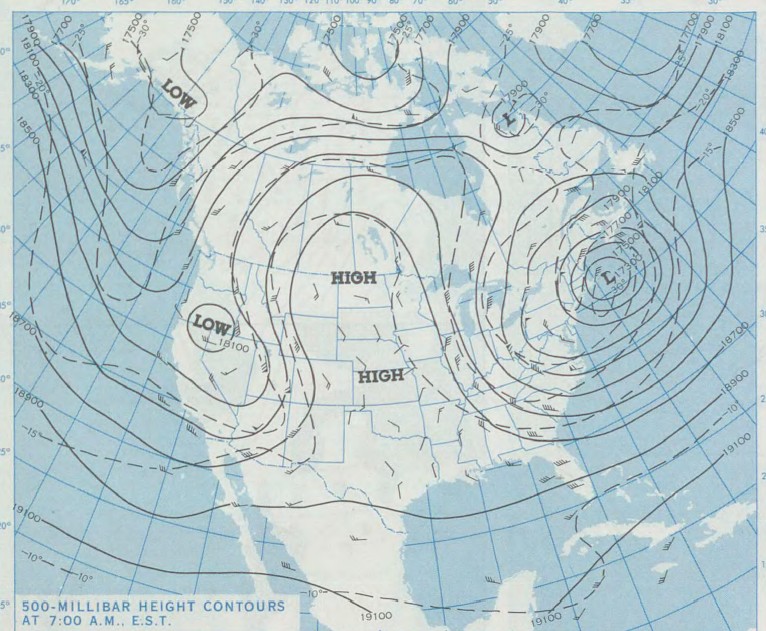
Given the amp'ed pattern and omega block, why not? As I noted earlier, "this is how do you it" this time of year. Look at May 9-10, 1977. Omega block just the same. And it does not have to be as amp'ed to do it either. Enter May 25-26, 1967. Same pattern, yet not as weenie Xtreme. MA/NH summaries for the storm attached. If this occurred today? CoastalWx would give new meaning to his line "VIOLENTLY BEAUTIFUL!"


-
In other newZZZZZZZZ that Wxwiz will be . So far this May, only 26 tornadoes have been confirmed, and w/ the pitiful pattern for the next week, not that many more should occur. The record for the least amount of tornadoes in May in the U.S. since 1985 is 121 set in 2012. So it appears we will break this record by far! Here are the records for each month. Sure, one can pick any year for a start time, but I chose 1985 since second half of the 80s had a significant spike down for total tornadoes, not unlike 2012-2016, so I am trying to include up/down cycles long-term w/o compromising total count caveats. * Lowest U.S. tornado counts by month (since 1985): January 1986/2003 0 July 2012 37 February 2010 1 August 2014 33 March 2015 11 September 2009 8 April 1987 20 October 1987 1 May 2012 121 November 2009 3 June 1988 63 December 2003 1 So where is this good news in the MSM? This is a significant record. But doesn't fit the "end of days" wx/climate narrative. They are focused on speculation/conjecture instead of *facts*, like this: https://www.ktvq.com/news/montana-ag-network/massive-northeast-montana-dust-storm-raises-fears-of-another-dust-bowl-era What I find interesting is 7 months had their least on record 2009-15. And this occurred w/ tornado detection/documentation being much better than decades prior. So again, good news for society as a whole, but ignored.
-
Yes, but we do need the rain, and many in NYC-SDF-OKC-HOU-MSY-JAX outlined zone are get it good, and will continue.
-
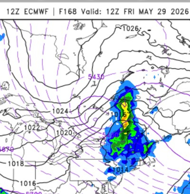
Accumulating snow in June outside of MWN or AOA 5000 ft is very rare in New England. Look at the 168 hr 12z ECMWF. Nice cold cut-off at 500 dropping SSE. That how you do it this late. The most Xtreme 500 case was May 9-10, 1977. You could track the upper low from northern Hudson's Bay all the way to S of LI, where it became a massive 5 contour 500 cut off (going by every 6 dm). Of course, it would take an truly extraordinary set up for Scott to see flakes in June here! The June 6, 1816 S+ in NNE had the benefit of the volcanic cooling combined w/ a strong sun Maunder minimum.

-
24 F at SLK. FYIIIIIIIIIIIIIIIIIIIIIIIIIIII....
-
Scott would disagree...
-
Oh I have stories! Scott's lame excuse is, "most posts are in the sports zone section!"
-
-
It was right along the warm/coastal front. Brunswick (KNHZ at the time) showed the sfc winds veer quickly and temps rose in the low 40s, after being in the upper 20s w/ several hours of S-. Very cold aloft and ocean temps still a bit mild in Nov, so there you go!
-
Scott likes "S Coast specials" esp. the AM one on Aug 4, 2015 in RI!

-
Yes, Rochester/Dover to Hampton do quite well. I have a couple of pix from the May 21, 2006 tornado (not mine) that show it very well. I'll post them once I get home tomorrow morning. Hampton Beach is the site of a significant tornado in 1898! NH JUL 4, 1898 1530 3k 120inj 100y 1.0m F1 ROCKINGHAM - Tracked southeast across Hampton Beach. Three fatalities by falling timbers at a skating rink where over 100 people had taken shelter from the thunderstorm. 20 cottages were destroyed. CoastalWx benefits from enhanced tstm activity in Weymouth, but for a different reason. The convergence of the S and E coast sea breezes gives him a bump. You can actually see a weak local total lightning bulls-eye from climo over his area!
-
Wxwiz should make a New England version! https://atlas.niu.edu/alerts/
-
I will say this event was rather impressive given the slightly anticyclonic flow aloft. Usually w/ such hot temps and that kind of flow aloft, it remains capped. One thing though the cell coverage did to rage into a SQLN at first. Cells were small clusters but intense.
-
I may have mentioned this before, but there is something physical about the NH seacoast that make tstms better or intensify here. Today was no exception, and two waves back-to-back! Isles of Shoals gusted to 63 mph. I realized this anecdotally as a kid being at Hampton Beach on vacation each summer, but that can have bias b/c everything is larger than life when you are kid, and any beach view is going to look more impressive overall for storms. Once the SPC hourly mesoanalysis product came out, I started to watch closely. What seems to be a factor is that there is at times locally higher 0-1 or 3 km shear/helicity on or just off the NH coast. Despite the cool ocean temps, a sea breeze here appears to result in intensification of storms in the area. Not necessarily svr, but a line of showers suddenly becomes active w/ CGs and weak mesos form, as one example. I've seen too many times for it to be just coincidence. What may be happening is this - first, once you get to the MA/NH border, any marine stabilization from S of SW winds coming S of LI basically becomes a non-factor. Second, and most importantly, the low-level winds over Cape Ann are briefly lessened, then pick up again once over the ocean, only to slow again once reaching the ME coast. So this sets up locally better low-level shear/helicity profile for cells to feed off of. For years, I have informally called it "The Hampton Effect." One of most outstanding example was on May 21, 2006. A nasty bowing squall line was ripping across central/southern New England. Once the northern part of the line got E of ASH, it gusted out enough that the leading edge cells weakened considerably, so there was nothing but RW-/RW and a bit of thunder. Once that outflow got to I-95, an isolated supercell developed very quickly and produced tornado at Hampton Falls. Lasted only about 30 sec, but it was clearly visible as a stout narrow column. See story here: https://www.timesargus.com/news/weather-service-confirms-tornado-hit-coastal-n-h/article_ed848d36-9e43-5117-aae8-97098039f6ab.html A waterspout also occurred not far offshore from Rye Beach. When I saw this and the radar loop, I said, "you've GOT to be kidding me, since when in New England does a tornadic supercell form on a edge of a gust from from a decaying squall line?!" And SSTs on the NH coast are still pretty cold in mid-May, yet that did not impede things at all. I think the only other time I was flabbergasted like this was the two mini-supercell tornadoes occurred in the Brunswick ME area on Thanksgiving in 2005. This was after a couple of inches of snow has just fallen here in the previous several hours!
-
Latest NAM/GFS MOS shows 87-88. So where do you think the NBM is getting 95 from? 2m temps? But I checked the HRRR/NAM/GFS/ECMWF, those do not show any higher than 89-90.
-
Noted GFSX MOS did not have BOS any higher than 66 Thu-Mon. Scott looking forward to SCT FROST in SNE Fri AM?
-
PT time in central NE on Sunday. https://www.facebook.com/share/v/1B8qsia4xS/ https://x.com/wxsarahk/status/2056137683366265143
-
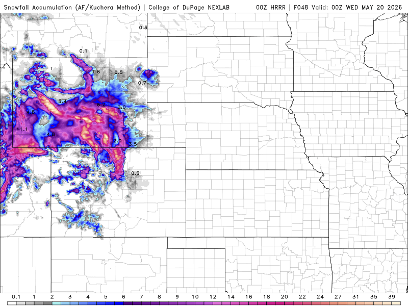
We are so into the svr wx/warm season, it is easy to overlook winter-type events this time of year! Anyone happen to look at what will happen in the Central Rockies in the next 2 days? Going by the HRRR Kuchera it shows up to 51" in the Wind River Range in WY, 35" in the mountains NW of DEN, and 37" in the Uinta Mountains in UT. The RRFS shows similar totals. Looking at temps fcst for elevations 10,000 ft and above and 700 temps (10s and 20s F) and total QPF, these amounts do not seem unreasonable. Even Denver proper may get 1". Road trip for Scott? LOL! This is the second significant snowstorm this month for the Central Rockies, and while not a drought buster, it certainly will help. And this shows that you can't write off a winter as to snow records in this area until May is done. This is in spite of the record hot wx in March, which I think MSM just thought "that's it for snow - it can't possibly happen any more this season b/c of that record hot wx!" This goes back to what the MSM as to what they consider the snow season w/ an obvious bias to what happens on the East Coast. And in a larger climatic sense, what matters in the end is what happens for the entire season, year, or decades for rain/snow, not short period individual events within these. I realize that the Rockies snowpack this past winter remains record low stats, but for total snowfall and precip, it is, or will be, no longer in record low territory for many locations. This will be ignored by the mainstream. They only care about what happens in the here and now, taking a snapshot of record low snow earlier in Feb, and running w/ that, providing no context, perspective, or follow-up.
-
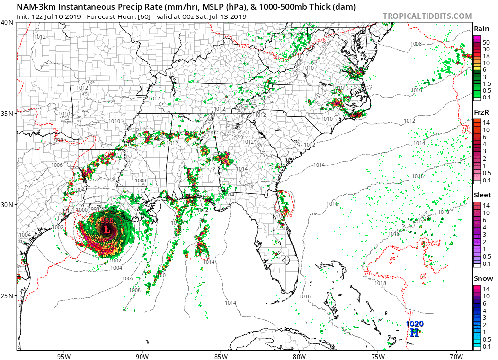
On the topic of the NAM going away and all the "consternation," remember what it can do w/ TCs. Look at this from Barry in 2019 (attached). 866 mb? Yeah, right. And you'd get hype-masters out there posting such as if it could happen! Barry ended up a min hurricane, but even that was really pushing it! Saw this... NAM 3km no longer turns off latent heat fluxes when RH approaches 100% at the lowest model level (as of 2017?). Despite the decrease in thermodynamic disequilibrium that happens in near-sfc air mass approaching saturation, hurricane-like conditions coupled with the model sfc parametrizations still force an unrealistic amount of evaporation into the boundary layer (you can guess what that does for TCs in the model . . .) . Capping those fluxes would be an artificial way to stymie extreme TC intensification rates, but it'd keep the model closer to reality. I believe they removed the global capping to improve forecasts of west coast marine fog, they weren't concerned with TC forecasts. So you can't have it all ways when it comes to mesoscale models/CAMs. There are aspects of the RRFS that performs better than previous models, and some that do not. Par for the course these days b/c it is not a linear challenge (more exponential) as you get more resolute and directly simulate atmospheric processes instead emulation/parameterization. And for the two big snowstorms this past winter, RRFS was not out to lunch. It did well and shows some mesoscale features in one of the storms that verified that no other model had. Shouldn't that be enough for ACATT?

-
-
Thanks for quantifying it w/ hard stats. I had never looked them up. So clearly the driest period in the last 60 years in the NEUS?
-
Yes, the last real multi-year drought in New England was in the 1960s, and yet the media has turned the word "drought" into a fear-mongering term, acting like its very existence is somehow atypical. Every time we get into a extended period (up to 6 months) dry here, it always seems to correct itself after this time. But that's not good for the fear-mongers, they just invented "weather whiplash" to still be negative/gloom and doom. What, do they expect gentle April showers all the time and no drought conditions ever?
-
How about "hot?" Somehow temps in the low 80s now have become "hot" on local TV forecasts. It all falls in pushing the "hot" narrative overall. 85-90 or upper 80s historically has been hot for New England in forecasts.
-
Given the sfc low tracked/developed right over SNE, are you surprised? Scott needs to look up his 700 low track rule for dry slots!