vortex95
-
Posts
1,488 -
Joined
Content Type
Profiles
Blogs
Forums
American Weather
Media Demo
Store
Gallery
Everything posted by vortex95
-
Any accumulation?
-
This guy is a super hype-master. Goes off the deep end w/ "heat dome" all the time. Every ridge of high pressure is a heat dome even if there are no sig warm anomalies present. Can't find big heat in North America? He goes to Europe w/ hot wx/heat dome hype, as if it having hot wx and anomalies somewhere on the globe at any given time is unusual?
-
https://dd.meteo.gc.ca/doc/genots/2026/05/25/NOCN03_CWAO_251940___18749 NEW VERSION OF THE GLOBAL DETERMINISTIC PREDICTION SYSTEM (GDPS) OF THE METEOROLOGICAL SERVICE OF CANADA (MSC) ON TUESDAY, MAY 26, 2026, STARTING WITH THE 12 UTC RUN, THE CANADIAN METEOROLOGICAL CENTRE'S GLOBAL DETERMINISTIC PREDICTION SYSTEM (GDPS) WILL BE UPDATED TO VERSION 10.0.0, SPECTRALLY NUDGED BY THE GEML (GLOBAL ENVIRONMENTAL EMULATOR) ARTIFICIAL INTELLIGENCE-BASED MODEL. SOME OF THE KEY ENHANCEMENTS TO THE GDPS IN VERSION 10.0.0 ARE: - SIGNIFICANT IMPROVEMENT IN FORECAST ACCURACY OF GDPS 10.0.0 COMPARED TO THE OPERATIONAL GDPS 9.1.0 - IMPROVEMENTS ACHIEVED THROUGH LARGE-SCALE SPECTRAL NUDGING TOWARD AI-BASED GEML FORECASTS - ROBUST AND STATISTICALLY SIGNIFICANT GAINS IN THE FREE ATMOSPHERE, PARTICULARLY IN THE MID- AND UPPER TROPOSPHERE - SIGNIFICANT GAINS BETWEEN DAYS 3 AND 10: MORE MODEST IMPROVEMENTS DURING THE FIRST 2-3 FORECAST - IMPROVED PREDICTED TROPICAL CYCLONE TRACKS FOR DETAILED INFORMATION ON THE INNOVATIONS AND PERFORMANCE THAT ARE ACHIEVED THROUGH THIS IMPLEMENTATION, PLEASE CONSULT THE SECTION ENTITLED: DATA AND PRODUCTS OF THE GLOBAL DETERMINISTIC PREDICTION SYSTEM, WITHIN THE MSC OPEN DATA PAGE AT THE FOLLOWING LINK (IN LOWER CASE): HTTPS://ECCC-MSC.GITHUB.IO/OPEN-DATA/MSC-DATA/NWP_GDPS/ README_GDPS_EN/ PLEASE ADDRESS ANY QUESTIONS CONCERNING THIS IMPLEMENTATION TO (IN LOWER CASE): F.PRODUCTION-INFO.F(AT)EC.GC.CA SIEWE ADM-MSC / SMA-SMC OTTAWA
-
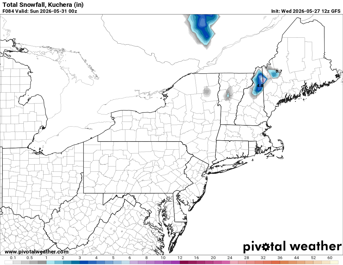
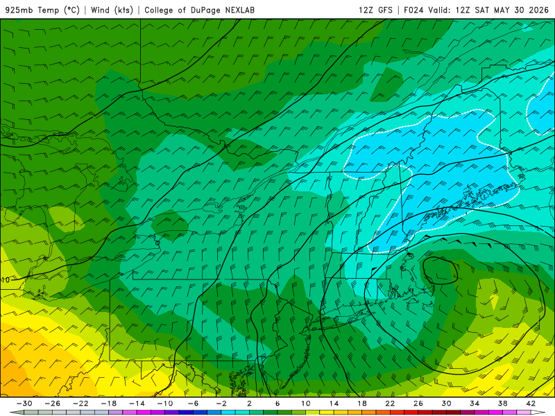
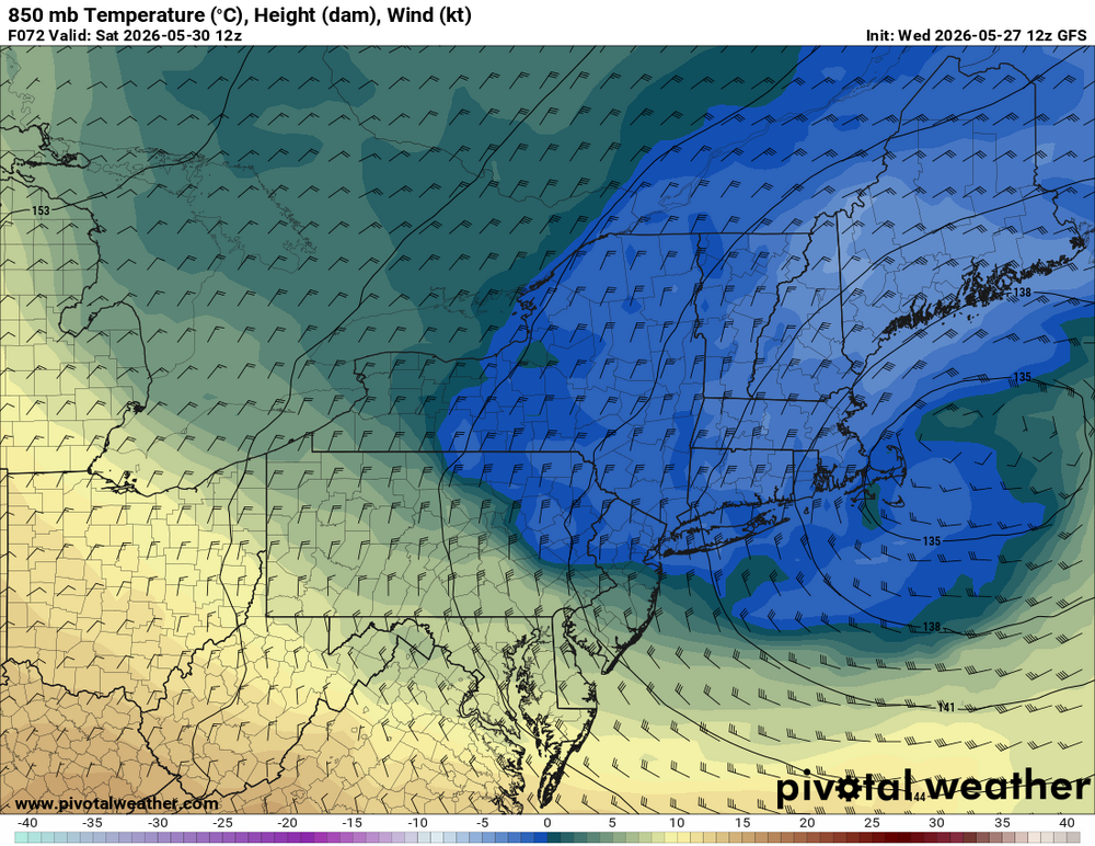
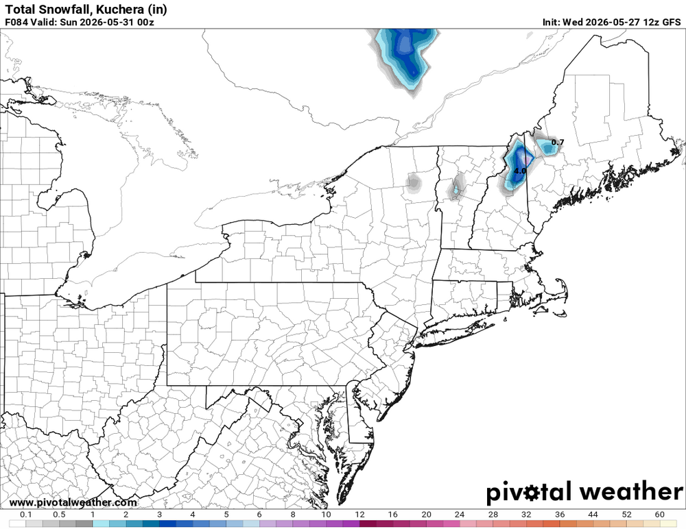
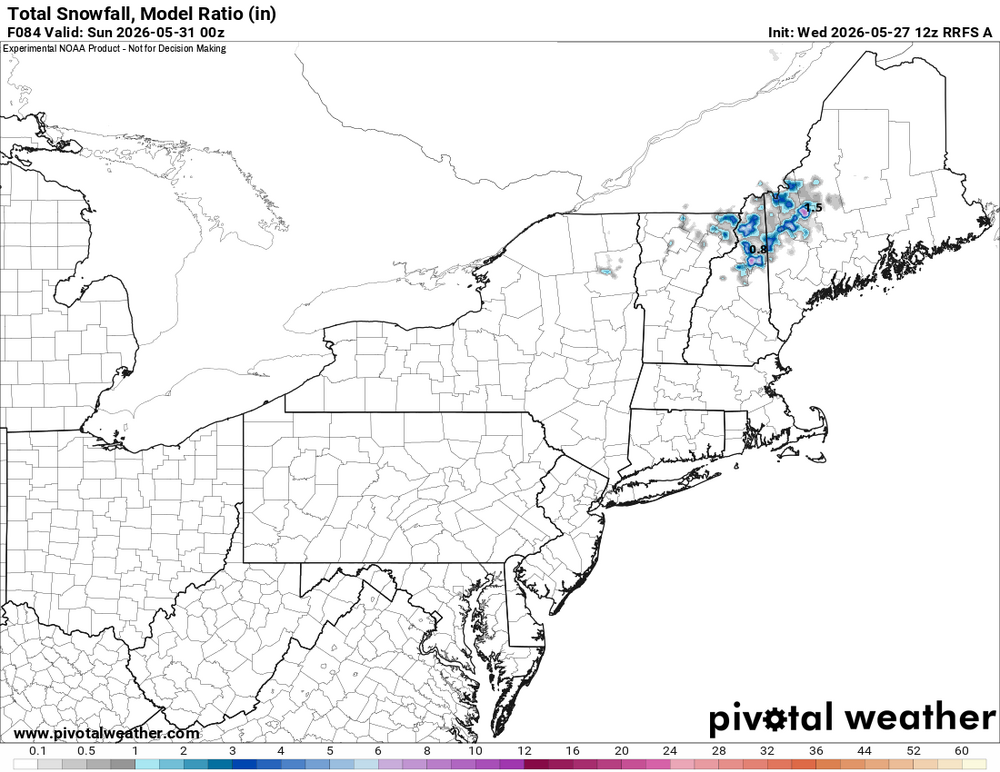
Good! They can get a better snowfall measurement! Maybe snow will not be so wet here. Those are cold temps. Well, GFS now has 850 temps as low as -5 C across NNE so there you go! W/ such cold temps at 6000 ft, you have to think that down to 2000 ft in NNE could do very well w/ super wet glop.
-
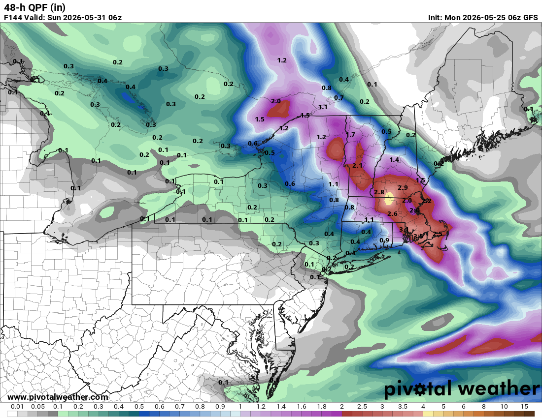
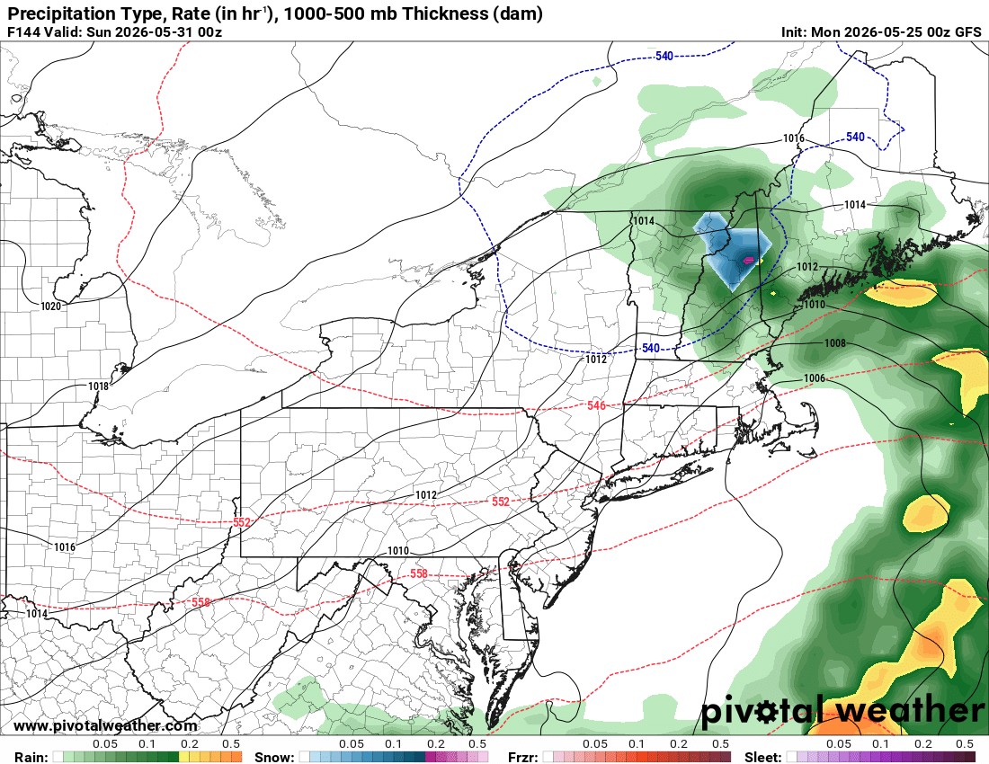
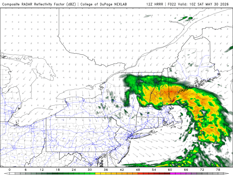
Also posted on the thread just made for this upcoming storm. Interesting what the 12z HRRR shows. It has a very high QPF max of 5.77" over SW ME. Other models do not show this, but sfc low is a tight SUCKA and I wonder about mesoscale factors. SPC has general tstms outlooked and convection stirs things up better aloft. This results in stronger downdrafts to mix down the cold air aloft better. 850 and 925 mb temps are cold enough by 12z in this area and that kind of pcpn intensity? The ante is very high here! Can you imagine on the coast w/ super paste and G50kt? I'd love to be at Hampton Beach Sat AM! The reason the HRRR shows this big pcpn max in SW ME is b/c the area is at the pivot point of the N side of the comma head, so they cash in w/ a heavy pcpn area nearly stationary in a relative sense. Such a scenario is not unreasonable and the global models would not pick up on something like this. So we may have two pcpn maxes, one over the White Mtns and another coastal ME/NH. Look at the HRRR sim radar late this eve/very early Sat over NH/VT, TRW+ FQT LTGICCG surprise before the S+??? This is about as good as it gets for the uncertainty factor for big S+ and "PHUN 'N GAMES!" Scott should be impressed! Could be a truly exceptional event. Big snowfall like this so late (higher and lower elevations)? You have to go back to the 19th century (1816 and 1842 in June) for anything later. MWN had 24.9" in the May 25-26, 1967 event and they could exceed that for the May single storm record.


-
Interesting what the 12z HRRR shows. It has a very high QPF max of 5.77" over SW ME. Other models do not show this, but sfc low is a tight SUCKA and I wonder about mesoscale factors. SPC has general tstms outlooked and convection stirs things up better aloft. This results in stronger downdrafts to mix down the cold air aloft better. 850 and 925 mb temps are cold enough by 12z in this area and that kind of pcpn intensity? The ante is very high here! Can you imagine on the coast w/ super paste and G50kt? I'd love to be at Hampton Beach Sat AM! The reason the HRRR shows this big pcpn max in SW ME is b/c the area is at the pivot point of the N side of the comma head, so they cash in w/ a heavy pcpn area nearly stationary in a relative sense. Such a scenario is not unreasonable and the global models would not pick up on something like this. So we may have two pcpn maxes, one over the White Mtns and another coastal ME/NH. Look at the HRRR sim radar late this eve/very early Sat over NH/VT, TRW+ FQT LTGICCG surprise before the S+??? This is about as good as it gets for the uncertainty factor for big S+ and "PHUN 'N GAMES!" Scott should be impressed! Could be a truly exceptional event. Big snowfall like this so late (higher and lower elevations)? You have to go back to the 19th century (1816 and 1842 in June) for anything later. MWN had 24.9" in the May 25-26, 1967 event and they could exceed that for the May single storm record.


-
Shouldn't we have a separate thread for this upcoming storm now? It certainly warrants one IMHO! Give the super snow weenies on this board, I expect at least one to travel to the mountains of ME/NH just to experience a truly rare event. We need in situ snowfall obs as well!
-
PT time??? LOL. I recall how into you got w/ the Gulf Coast S+ last year. You said something like, "this is some SERIOUS SH**!!!""
-
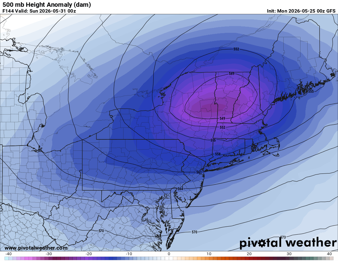
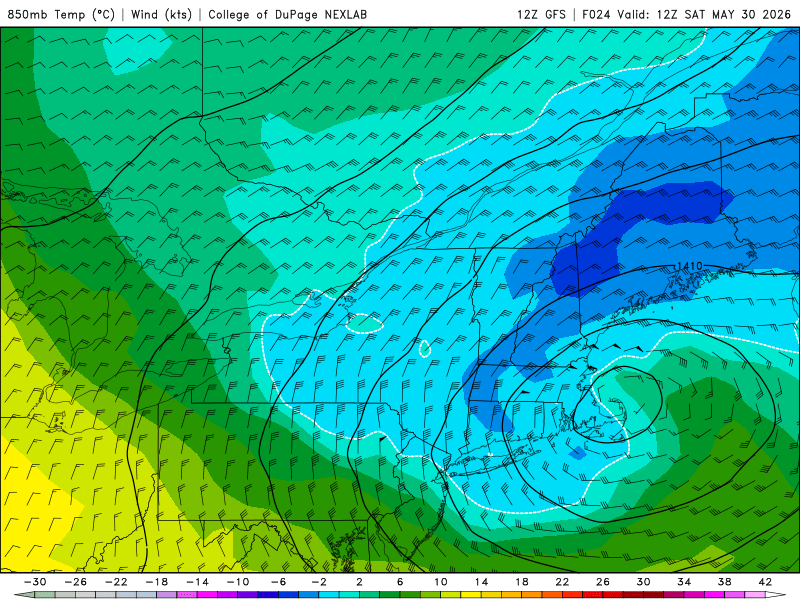
One thing that seems apparent as we get closer to the Fri-Sat event. Models are ever so slightly trending colder and deeper w/ the sfc low. We now have 1000-500 thk bottoming out very close to 534 NH/VT/MA and -1 C at 925 extended over parts of MA/CT/RI around 12z Sat on the GFS. And now the 18z GFS and ECMWF suggest slight accumulation in n-ctnrl MA. Of course precip intensity is an issue in SNE, but maybe not for far NE MA (18z ECMWF). Sfc low now peaks at intensity 999 mb just E of BOS and as noted, significant winds ME coast to Cape Cod. G50 kt psbl according to the HRRR. Sustained 40 kt fcst just offshore from PWM. I would not be surprised if there are isolated embedded tstms. Also, model ptype does not show this, but what about IP? Such cold 925 temps, a mix w/ IP into SNE is certainly psbl. So something to be reckoned w/ and the "surprise" factor is quite high in this case (i.e. snowfall in areas that do not expect it). No, Scott, it won't be a Dec 9, 2005 "wild turkey surprise!" LOL. 00z HRRR showing max of 27" at MWN. Why not? They had 24.9" in the May 25-26, 1967 event. QPF supports it. EDIT: Just saw the NAM. It may not be so far out-to-lunch here, maybe right for the wrong reason, but as I said above the "surprise" factor here is very high IMHO given the borderline temps and strong dynamics.
-
Sometimes it does not truly break into a solid summer pattern until July 4th! But you seem surprised what is going on now. It happens....
-
We do need the rain. Need to shut up local media acting like the drought is end of days.

-
Prattsville NY 8" for the highest for May 18, 2002.
-
The 18z GFS is the ultimate wheel of misfortune. The entire week into next weekend is ruined for Scott! Well, at least his lawn will be happy. And we do need the rain. Drought bust-A!!??
-
BAF also 84, so CEF seems suspect.
-
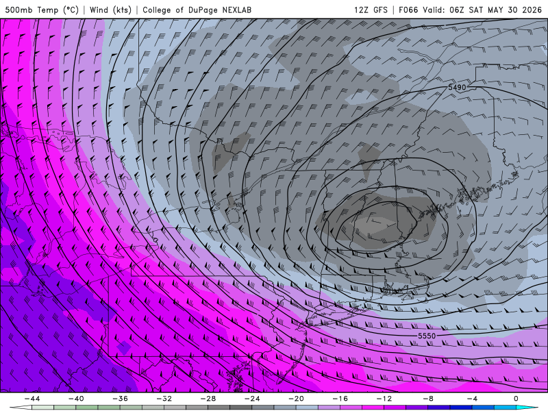
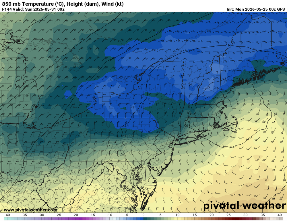
I am surprised there is not more talk about the weekend event. You know how rare these kind of events are in May? And as I said, omega blocks are how you do it this time of year. People like CoastalWx seem to fail to appreciate atypical/rare wx events since it ruins great outdoor weather or the like! In other words, as one example, "if it's not the cold season, I don't want snow!" Or more precisely, "if it's not IMBY, I don't care!" LOL. Grousing all the time seems to be SOP. GFS and RRFS explicitly show accums in nrn NH/NW 4-8" at the higher elevations. Look at the 850 temps valid 12z Sat. That's *cold* and colder than previous runs (as low as -4 C). The 500 low passes directly over the area for max dynamic cooling. Not something to just ignore. Also, and this is huge this time of year, the heaviest precip occurs during the overnight late Fri-early Sat. Every degree counts this time of year for snow. We are talking about say a 0.5 F deg difference in avg temp of the lowest 2000 ft here could mean just a mix of rain/snow or heavy snow w/ rapid accumulation. So being at night given the strong sun angle this time of year (a factor even when thick clouds are present) matters a lot. And given how borderline the temps are, this often results in a very fickle precip type situation. When the precip gets heavier, it goes to all snow, and it lightens up, and goes back to rain. It will be something that needs to be watched very closely in real-time. The "surprise" factor is high here. And you don't need an event like May 9-10, 1977 for the fun 'n games. Look at May 18, 2002. Omega block was much farther N and the 500 cut off center was no where near NEUS. We are also talking later than any other snow event here in the last 60 years, later than 1967, 1977, and 2002.
-
Scott likes the June Nor'easter the GFS has early next week! Wheel of MISFORTUNE at 500 mb!
-
But your lawn you value so much will like it!
-
Misleading. Measurable rain overall entire weekend says nothing about the sensible wx overall. Case in point, if Wxwiz got honkin' tstms every weekend in the summer amidst HHH conditions? Heck, even CoastalWx would welcome that! And Logan is just one point. They act like when it rains it is synoptic coverage by default!
-
It's going to be that type of event where we may not know until it actually happens, if it does. The fact that the GFS/ECMWF/GDPS/UKMET has shifted the heaviest QPF into NNE, that makes it more likely. Look at the cold 850 temps NW of the 850 low. It's never going to look like a lock, even close to it, for snowfall this time of year. Fun 'n games watching noodles and cats paws on the car windshield. Scott may just travel to NNE for one last look at winter 25-26! LOL. The 00z ECMWF for after the weekend event? Omega "Supreme" does not want to go away. Not 1, not 2, but 3 more cold 500 lows NEUS! And another weekend potential ruined June 6-8 w/ back-to-back coastals.
-
KNFJ - Milton/Choctaw NOLF FL KNGW - Corpus Christi/Cabaniss NOLF FL KNMT - Tilden/McMullen Target Site TX
-
It will be worth it for the sneaky S+ risk! Noted the 06z GFS has a max of 4.55" rainfall right over FIT. Seems a lot for such a low track. Where is all the moisture coming from, esp. since there is not much of a sfc low initially? GFS not so OTL it seems b/c the 00z ECMWF has a max of 2.81" in the same exact spot. That kind of pcpn intensity and a cold 850? Things that make you go hmmmm....

-
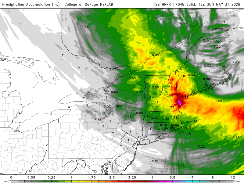
00z GFS significantly stronger and tucked back farther W w/ the closed 500 low for May 30. It shows 4-8" parts of nrn NH. What stands out is that the 00z GFS/ICON and the earlier UKMET show substantial QPF, 2-3" in some areas. This is absolutely key for the Scott S+ this time of year (intensity). I like that the GFS is showing more sfc low development just S of the region for more ageostrophic flow.


-
Look like a strong El Nino pattern we'd see in winter, except it's still not El Nino yet!
-
"You heard it here first!"
-
Like how bad it got in the summer of 2016? An extreme drought area showed up in MA! OMG, the world ended! The Quabbin is 84% capacity now. It got as low as 79% in Dec 2016. Clickbait post.